
| Station's 12-24 Hr. Forecast: Increasing clouds with little temperature change. |
|
Last Day of Significant Rainfall with Total:
21 Jul 2026 (0.03 in) 17-Jun-2017 9:35 AM Station Status Update for June 17th, 2017 --- Anemometer Failure! Sometime overnight, the Anemometer's Cup Assembly detached from the body of the gauge and fell to the ground, rendering the device inoperable. We still have wind direction data via the vane but obviously no longer any wind speed data. The top of the existing mast is unreachable through conventional means, so the only viable solution will be to erect a secondary mast on the roof of the house adjacent to the ISS Mast and then fit our new back up Anemometer to the top of the new mast. Unfortunately, do to very limited resources, we have no ETA on when a secondary mast can be obtained and eventually installed. As a result, D2149 will be unable to report wind speed data to our own site or any of our partner weather sites until further notice. Wind Data Feeds to CWOP have been suspended, but sites such as Weather Underground do not allow for selective data transmission. Those sites will continue to show a wind speed of 0 MPH at all times until such time as the replacement wind gauge can be installed. We apologize for any inconvenience this may cause our visitors. End of Station Status Update 12-May-2016 1:07 PM Station Maintenance Heated Rain Bucket removed from ISS and replaced with standard non-heated version. [end of update] 02-Mar-2016 2:20 PM Station Back Online with new 6163 ISS Installed The swap and installation of the new ISS has been completed. All systems check out perfectly. Just in time for some long awaited storm action! [end of update] 02-Mar-2016 12:03 PM ISS Upgrade Installation Later Today The station will be offline for about an hour later today while we install our brand new upgraded VP2 - 6163 Integrated Sensor Suite (ISS). Because we don't have an exact time on when the new unit will be delivered, we are just going to advise everyone who monitors our station on the various internet based weather sites to expect some downtime between 1:00 p.m. and 6:00 p.m. today. We don't expect the swap to take more than an hour, including time to allow the new sensors to "Settle In" and stabilize with the location prior to bringing them and the rest of the station hardware back online. We will post a followup message later today after the installation has been successfully completed. [end of update] 21-Feb-2016 11:32 AM Major Issues Developed During Routine Maintenance of Station's ISS During the routine replacement of our FARS fan and overnight battery backup the TEMP/HUMIDITY Sensor and main sensor motherboard was accidentally shorted out by canned air frost and severely damaged during this cleaning. The electrical damage was severe and was deemed unrepairable. As a result, we were unable to restore normal service as planned yesterday and instead were forced to bring out our original VP2 ISS from storage, test its various sensors and repair the primary issue that originally prompted its replacement back in 2012. This unit (6152) is nearly identical to our current system with the exception of a Daytime Only FARS fan system vs the 24 hour FARS running on our 6163. Early yesterday evening as the backup ISS was being installed, the RJ11 cable that connects our Wind Sensor (Anemometer) to the main sensor circuit board was damaged forcing an additional delay until this morning where the damaged cable was repaired, the system tested for a third time and finally brought online just before 11:00 a.m. today. Basically... everything that could go wrong with yesterday's maintenance procedure did go wrong! If it were not for our original, eight year old VP2 ISS still being available and its own issues repairable, we would still be down today as we await the arrival of a brand new replacement VP2 Plus 6163 which we ordered today and hope to have installed by the end of this week. Accuracy Note: We are noticing a few degrees of over reporting of Temperature by the backup ISS at this time. Since the device was quickly installed and was not allowed to "settle" before brining the system online, this few degrees above normal might correct itself over the next 24-36 hours. If not, then our temperature reports can be considered slightly above actual until the new 6163 replacement hardware arrives and replaces the backup ISS. We will update the Journal once the new 6163 has been installed, tested and brought online towards the end of this week. More than likely Thursday or Friday evening. [end of maintenance update] 20-Feb-2016 11:21 AM Station Temporarily Offline for FARS System replacement * Saturday, 02/20/16 Please see previous Journal entry for more details. 19-Feb-2016 2:12 PM Scheduled Station Downtime for FARS System replacement * Saturday, 02/20/16 The station will be taken offline on Saturday afternoon February 20th, for replacement of a failing FARS fan and FARS battery backup. The replacement should take 1 - 2 hours to complete and requires the station's ISS (Weather Sensor Array) to be powered down and removed from the mast. D2149 will not be able to report or record weather data during this downtime, so weather data occurring during this maintenance procedure will be lost and will not be included in the station's historical data logs. Users will be able to identify this maintenance procedure by a lack of weather data updates to all online reporting sites that D2149 normally reports weather data to every 2 minutes or less. Notably our own website and Weather Underground. We are currently planning to take the station offline between 11:00 a.m. and 12:00 p.m. tomorrow. We expect all systems to be back online and fully functional no later than 3:00 p.m. Saturday afternoon. A follow-up announcement will be posted here when the fan and fan battery replacement have been completed and all performance tests on the new components have been completed successfully. [end of maintenance update announcement] 25-Apr-2015 9:27 AM OVER ONE INCH of RAIN from SURPRISE STORM SYSTEM! We are pleased to report that the station just tipped us over to 1 inch of rain recorded in the last 5 hours with 1.11". Once the precipitation started just after 3 a.m. this morning it has not stopped since! However, the last of the rain band is just now passing over us, so unless we get some thunder storm activity later today, this might be it for the day. Here are the latest precipitation stats from the station: Storm Totals Since 04/23: 1.51" For the month: 2.16" For the season: 15.37" (About 25% of normal) Since January 1st: 5.43" (About 20% of normal) [end of update] 05-Apr-2015 12:22 PM Station Maintenance Update Heated Rain Bucket Re-Installed - CR-123 ISS Battery Replaced In light of the forecasted low snow levels on Tuesday from a late season storm, we decided to reinstall the heated rain bucket on the ISS sensor array just in case we actually get snow here at 3590 feet.. We also replaced the CR-123 Lithium backup power battery which supplies power to the ISS sensor array at night. The existing battery was still returning good voltage, but it has been in operation for nearly two years, so it makes sense to replace it just to be on the safe side. A well used CR-123 battery like the one we just replaced can fail suddenly without warning and we definitely do not want that happening in the middle of a snow storm. Transmitter battery tests on the new battery were all normal with a steady output voltage of 4.523 volts. Right where it should be! Now we just need some rain/snow to make all this worth the trouble! [end of maintenance update] 03-Apr-2015 8:27 PM UNSETTLED WEATHER RETURNS BEGINNING SUNDAY! 50% Chance of Rain on Sunday * 70% Chance of Rain/Snow on TUESDAY APRIL 7th! We know you are rubbing your eyes right now trying to make sure that you read that headline right! We did the same thing when we first got the inside scoop from the guys down at Hanford, but as the model runs stand tonight, things are looking better and better as we move closer to the predicted events. But as with all the forecasts during the worst drought in California history, there is always the chance that everything can go south at the last minute and leave us literally high and dry! HIGH as in above normal temps, and DRY as in, well... NO RAIN! We will be posting additional updates over the weekend and into early next week when the second and more potent of these two low pressure systems makes landfall. [end of update] 27-Mar-2015 5:15 PM New Record High Temperature for March Set Today! The station recorded the hottest daytime temperature for the month of March we have ever seen with a 80.3 degrees F. In addition to a high temperature more typical of early June, the station also recorded one of the lowest relative humidity percentages we have seen for this time of year of 24% RH. The new record high for the month surpassed the previous 78.7 F set back in March of 2013. A typical monthly high temperature for Bass Lake at the end of March is 71 degrees Fahrenheit with relative humidity lows in the 50-60% range. This of course does not bode well for the wildfire risk/danger heading into what is likely to be the hottest and driest summer Bass Lake has ever seen. The current fire danger is at the top of the "VERY HIGH" range and will likely move into the "EXTREME DANGER" within the next 24-48 hours. Extreme Danger is the highest level of wildfire danger/risk there is, and as recently as 2009 through 2011 we did not even approach that level of fire risk until the end of August, and then only for a few days at a time if we reached that level of risk at all. In fact, during a normal year, the fire season wouldn't even begin until the middle of May! For the last three years in a row, the fire season has continued through the entire calendar year due to weather conditions like we are seeing today. [end of update] 25-Mar-2015 1:21 PM Maintenance Update: Rain Bucket Heater Removed 4 weeks early! For the first time in the station's six year history, we have replaced the heated rain bucket with the standard non-heated bucket before the second week of April! Long range forecasts indicate virtually zero chance of any snow events for the remainder of the season. Due to the horrendous drought conditions plaguing the Southern Sierra resulting in a complete lack of snow, we only activated the heated bucket ONE TIME this entire wet season. Down from an average of 10 activations per season of years past. A pretty depressing fact indeed. [end of maintenance update] 06-Feb-2015 12:09 PM FINALLY! Some Long Awaited RAIN arrives for February! The latest NWS forecast for Bass Lake is looking VERY promising today! Its been ages since we have seen 100% rain chances in our forecast, leave alone for multiple days in a row! The precipitation forecast is still suggesting some truly impressive rainfall totals for us! While this wouldn't make up for the terrible January we just endured, this will at least put us on track for a possibly normal February. Provided of course that these systems are not the only two we are going to see this month. We will update the journal with some storm totals over the following 36-48 hours. [end of update] 13-Dec-2014 8:04 AM Rainfall Totals as of 12/13/14 Storm Total: 2.49" Yesterday: 2.44" Today: 0.05" For the month: 4.40" For the Season: 7.98" For the year: 22.69" For Last Year: 10.91" For Typical Year: 56.97" (2010 Shown) [end of update] 05-Dec-2014 5:13 PM More Rain On the Way! then... Even More Rain! Believe it or not, we have yet another storm system heading our way with light to moderate precipitation expected through tonight and into the early morning hours Saturday. For those who are going to be out and about on this Friday night, you can expect the rain to start falling in our area anytime after about 8PM. Shower activity is expected to be light to moderate in strength, but there is still the possibility of isolated thunder storms capable of producing heavy rain, so be advised of this possibility if you are traveling on our local roads after dark. This system moves out by Saturday night, but as we mentioned in the headline, a larger more impressive storm system is currently forecast to arrive over our area on Thursday of next week and is expected to bring us several days of wet weather. Unfortunately, all of the storms seen so far have originated in the mid latitudes of the Pacific Ocean and as a result, they are not bringing with them the cold air required for lower snow levels. So while the rain is great news, we are still waiting for the winter pattern change which will start bringing the cold storms down from the Gulf of Alaska and points north. Until then, we are not going to see any significant change to our Sierra Snow Pack below 8000 feet. In fact, there isn't a snow pack below 8000 feet so far. This is something we hope changes soon since a healthy Sierra snow pack at all the traditional elevations is crucial if we ever hope to break this drought that has plagued us for going on three years now! We will close this update with a reminder that you can always track this and future storms from your own computer by visiting and bookmarking our popular "Wide Angle Precipitation Map" who's link is available from the gray nave bar of our home page "during" rain events. Latest NWS Forecast Discussion: Area forecast discussion National Weather Service San Joaquin Valley - Hanford California 348 PM PST Friday Dec 5 2014 Synopsis... another weak system will bring some light showers into the area mainly north of Kern County tonight. Dry conditions are expected by Saturday night with nighttime and morning valley fog as high pressure briefly returns. Another weak system is expected to skirt across the northern portion of the state on Monday...with light rain possible north of Fresno County. Discussion... it has been a relatively mild day across central California today under cloudy skies ahead of the next approaching weak frontal system. Radar shows associated showers impacting coastal areas to our west. High resolution models forecast these scattered showers to push east through our area this evening lingering into early Saturday morning...though the best precipitation stays to our north with the main energy. Valley quantitative precipitation forecast ranges from around 1/10 of an inch north to just a hundredth or so toward Kern County. Higher elevation amounts similarly taper from around a quarter inch near Yosemite to nothing in Kern County. Brief shortwave ridging behind the system yields dry and continued mild conditions Saturday and Sunday. Another weak ripple tracks by to the north by Monday...bringing just a slight chance for precipitation north of Fresno County. Otherwise...dry and mild continues into midweek. A more significant system...remnants of a super typhoon...is prognosticated to slam into the West Coast by Thursday. Models of course have differences in timing and strength of this system...but ensembles suggest there is a good chance that our area will be affected with rain and mountain snow as well as typical gusty winds over mountain ridges and through and below passes. This will be a somewhat warm storm with relatively high snow levels. As the event approaches we will be able to refine timing and amounts. ================== [end of update] 25-Nov-2014 8:04 PM Promise of our FIRST REAL Winter Storm Sunday! Models are starting to come into agreement about the potential for a significant winter storm to arrive over the area beginning late Saturday night and lasting through Monday. Rainfall amounts could total over 3 inches or more by the end of the event. We will update the journal with more details as we get closer to the event. Enjoy your holiday! [end of update] 13-Nov-2014 7:31 AM Some Welcome Rainfall for Bass Lake Today! A weak and fast moving cold front is passing through the area this morning. Radar indicates scattered showers moving in from the coast. While the bulk of the event has already past, we are watching a rather large cell of precipitation just now moving past the coastal range and headed for our location. Upslope activity has been good so far, so we anticipate some additional upslope generated precipitation through the remainder of the day. So far our storm total stands at 0.18" under moderate rainfall at the time of this report. [end of update] 11-Nov-2014 11:44 AM FARS Fan Replaced - Station Back in Service! Turns out there was a fault in the multi-pin connector where the fan plugs into the circuit board. The problem is repairable, but we decided to replace the circulation fan from our backup parts stock. The new fan is working perfectly and hopefully, we will get the usual 2-3 years out of this one! The station was down for 1 hour 17 minutes. [end of maintenance update] 11-Nov-2014 10:25 AM Station Down for Maintenance We are replacing the FARS fan and will have the station down for about 2 hours or less. We will update the journal after the process has been completed and the station is put back into service. [end of maintenance update] 09-Nov-2014 5:23 PM Station Maintenance Announcement We will be taking the station offline for a few hours on Tuesday 11/11/14 in order to replace the failing FARS air circulation fan on the outdoor sensor array. What is a FARS system? - "The following is a short primer on the technology for the hardware geeks in the audience." FARS is an acronym for Fan Aspirated Radiation Shield. It basically circulates fresh air through our sensor array 24 hours a day to provide the most accurate temp and humidity readings as possible. Without such a system, heat from the sun can overheat the interior of the sensor bay and result in the over reporting of temperature and to a lesser degree, humidity and dewpoint. This is especially true during the hot summer months. The primary reason many backyard weather stations are so inaccurate compared to professional systems is due in large part to the absence of such a component. The reason you don't see too many private stations running with a FARS is that a quality system like ours is expensive and can add several hundred dollars to the total cost of a system. But... Fans are fans! And unfortunately, they don't last forever... If you are keeping score, this will be our FIFTH fan replacement since the station went live way back in January of 2009. Because this fan runs 24/7 using a combination of solar power during the day and NiCad battery power at night, and is subjected to the extreme temperature and humidity swings of our mountain location, the bearings in the circulation fan eventually wear out and the fan stops spinning in low power situations. [At night and on cloudy days when the fan is being powered by the batteries and not the solar panel] Because the sun angle and length of daylight are so much lower this time of year, a fan nearing its end of service is more likely to give up the ghost between late October and early December. As a rule, we need to replace the circulation fan every 12-18 months, but for some reason, this particular unit only lasted 11 months, which is unfortunate considering the amount of hassle involved in replacing it! :o( The ISS sensor array needs to be removed from the mast and disassembled in order to remove the broken fan and install a new one. The whole process takes upwards of two hours, so the station will be taken offline completely while we perform the replacement. We are not sure exactly what time on Tuesday we will be taking the station offline, but it will be obvious to anyone checking our weather data when it is. We will update this journal just before the station is shut down, and again after the maintenance procedure has been completed and the station is returned to service. [end of maintenance announcement] 03-Nov-2014, 12:00 FINAL STORM TOTAL AND EXTENDED FORECAST Friday 10/31/14: 0.66" Saturday 11/01/14: 0.88" Final Storm Total: 1.54" Total for Season (Since July 1st): 2.34" Annual Total Since 01/01/14: 17.24" Annual Total for 2013: 10.91" Current forecast models are indicating that we are in for another long wait before another storm arrives into Central California. High pressure is building into the area yet again and will block the otherwise active storm track, pushing it well north of our area for the next 7-10 days at least. Temperatures will also be pushed 8-10 degrees above normal for this time of year by mid-week. While we are still in an extreme drought condition, you can see by comparing the 2013 annual precipitation total to our current 2014 total, that we have already exceeded the entire annual precipitation total for 2013 with two months left to go. One tidbit of positive news amidst an otherwise gloomy current outlook, and a reminder of just how dry 2013 actually was. Extended forecast through the middle of November looks bleak in terms of precipitation. It is looking very likely that we will experience yet another warm and dry winter through the 2014/2015 wet season. If we see any changes to the current dry and warm conditions, we will update this page at that time. [end of update] 28-Oct-2014, 12:00 Heated Rain Bucket Installation Heated rain bucket was installed ahead of the first winter storm of the season. In retrospect, it could have been postponed indefinitely due to the lack of snow during the event, followed by an extended period of warm and dry weather. Related to persistent high pressure ridge blocking winter storm track. In depressing repeat of the last two dry winters. [end of update] 30-Sep-2014 12:41 PM Weekend Storm Activity Recap Here are some rainfall stats for you as of 09/29/14 Storm total: 0.67" For the month: 0.78" Total for Season: 0.80" The system that moved through on Sunday brought us the Lion's share of the above totals with 0.60" from Sunday alone. While not a huge amount in normal years, the storm total is impressive considering we had only a 20% chance of light showers in the actual forecast! A warming trend will now commence with temps once again rising up to and then as much as 10 degrees above seasonal norms by the weekend. Currently we see no additional storm systems out through the 10 day forecast, although this time of year the forecasts can turn on a dime. We will update the journal again if current trends change. [end of update] 28-Sep-2014 3:24 AM We're Back from Summer Break! - First Winter-like Storm of the Season for the Southern Sierra! We're back from our annual summer break with a brief weather update regarding the first taste of a winter-like storm system this season! The station recorded a total of 0.06" of light to moderate rain on Saturday afternoon, and at the time of this update we are seeing some light to moderate rainfall from a sizable but narrow band of precipitation moving down the edge of the Sierra from the north. Our current precipitation total this morning stands at 0.04" with a rain rate of 0.12 in/hr. Storm total stands at: 0.11" Total this month: 0.22" Total for the season (Since July 1st): 0.24" We will now be updating this journal on storm by storm basis, so check back often during winter weather events for the latest information and up to the minute forecasts! [end of update] 06-May-2014 11:02 PM Lowest Seasonal Precipitation Total Since Station Began Operations in 2009 The station recorded 0.40" of rain today in a welcome late season winter storm that moved through the Southern Sierra last night and well into the early evening hours today. While this total was nearly double of what had been forecast for our area from this system, it did nothing to improve what is shaping up to be the lowest seasonal precipitation total we have recorded since the station was put into service back in January of 2009. The final 2013/2014 seasonal total could be revised upwards between now and the end of the season on June 30th if we are fortunate enough to see another storm system or two, but mid-May through all of June are traditionally very dry periods for us. Here is how our seasonal precipitation totals stack up over the last 5 years of 24/7 weather data collection. Seasonal Precipitation Totals for D2149 Bass Lake Ca. (July 1st through June 30th) 2013/2014: 19.04" (As of 05/06/14) 2012/2013: 24.18" 2011/2012: 22.41" 2010/2011: 55.92" 2009/2010: 49.61" It is clear from these totals when our current extreme drought began to manifest itself, and based on this latest seasonal total, our precipitation amounts year over year are getting worse, not better. There is some encouraging signs that a moderate to strong El Nino event could be building in the eastern pacific ocean which has the potential to deliver above normal rainfall to the entire state this winter, but it is still too early to say for sure if this event will actually occur, and how strong the anomaly will actually be. We will know more as we get closer to the end of summer. If this El Nino event does take hold, it will begin to have an impact on our local weather as early as this fall. We are closely monitoring this situation and will be posting new information on the latest El Nino data as soon as it is made available by NOAA and the NWS Climate Prediction Center. Stay tuned! [end of update] 26-Apr-2014 6:18 AM Impressive Storm Total of 1.85 inches! A nice way to end the wet season for sure! While it barely puts a dent into our drought conditions, it does help ease us into the fire season. [end of update] 24-Apr-2014 5:50 PM Rain Bucket Heater Re-Installed in Advance of Late Season Winter Storm Since there is a good chance for the snow level to drop below 4500 feet during the passage of the approaching cold front, we decided to re-install the heater equipped rain bucket on the station ISS just in case. We will post an update with final storm totals on Sunday. In the meantime, stay tuned to our home page and other relevant pages during the storm for the latest information and storm activity! [end of update] 09-Apr-2014 2:16 PM Rain Bucket Swap Completed Based on the extended forecast which includes highs far above normal, we have removed the heated rain bucket from the station ISS sensor array and replaced it with the unheated version. The unheated rain bucket will remain installed until the next chance of snow, which is not expected until this fall at the earliest. Statistically, the heater was only needed a total of FOUR times this past winter. The average number of heater activations during a normal wet season is over TEN. [end of update] 29-Mar-2014 9:28 PM Storm #1 Moves In! Radar is indicating the frontal boundary and precipitation less than an hour away from the station at the time of this report. Check our home page radars and the wide angle precipitation map for the latest returns! We will be posting storm totals sometime on Sunday. Enjoy the storm! [end of update] 27-Mar-2014 8:33 AM Over 1 Inch of Rain from Latest Storm! 1.13" was the final daily precipitation total for the system that moved through the area on Wednesday. This brings our March total to 1.54" and 13.70" for the season. The annual total now stands at 9.13" which is less than two inches away from the entire 2013 annual total. A small victory during this mega drought and indicates that we are not going to be seeing a drier year than 2013 going forward. How much more rain we receive this year as opposed to last year remains to be seen. The NWS is forecasting another system to affect the area of Saturday and yet another system is expected for early next week. We will be keeping a close eye on both systems as we get closer to the events. [end of update] 24-Mar-2014 12:39 PM Forecast Still On Track for Rain Tuesday Night Through Thursday Morning We will be tracking the eagerly awaited next storm system, still on track to arrive on Tuesday night. Currently, the NWS is estimating between 1/2 and 1 inch of precipitation for us from the this next system which ends on Thursday. Stay tuned to our home page for the latest real-time rain related activity and precipitation totals. We will update this page as well once we see something substantial coming in on our various radar sources. There is also another potential for rain a week from today, but still too early to say for sure if that prediction will hold. [end of update] 11-Mar-2014 8:25 PM Mono Wind Event for Tonight - Confirmed by Observations! High winds out of the north east are beginning to move in to the station location as of this special report. Speeds are still moderate (14 mph max gust so far) but the sound of higher gusts through the forest to our north east is a sure sign that stronger winds are on their way! Stay tuned to our station home page for the latest wind speed information or better yet... Check the wind speeds in real time using our Rapid Fire Instant weather page! We haven't had a chance to report on our final precipitation report for February but we will get to that soon. [end of update] 27-Feb-2014 8:23 AM Storm #1 Precipitation Total Currently Stands at 1.35" Unless we pick up some residual upslope generated showers or a Thunderstorm, this looks to be our final total for Storm #1. The station recorded a high rain rate of 4.17 inches per hour briefly as the cold front passed through the area just after midnight. One of the highest rain rates on record for the station. [end of update] 21-Feb-2014 10:51 PM Maintenance Update: Checked rain gauge and all related systems for highly anticipated wet weather event next week! All hardware systems were inspected, cleaned and then tested. Gauge and tipping bucket mechanism in full working order. We are ready for next week's desperately needed storm systems! Station Operator's forecast commentary... NWS extended forecast is looking more and more favorable for a wet pattern change beginning Wednesday 02/26/14. Current model runs are hinting at the potential for well over 1 inch of rain from two separate systems spaced about 24 hours apart. Second system forecasted to be the wetter and more powerful of the two. Snow level begins at 7000 feet, then lowering to 6000 feet as first system moves in. Initial snow accumulation estimates are for 1 - 2 FEET of new snow for the Sierra. If these systems do indeed materialize and track the course currently predicted, this will be a significant precipitation event. In no way enough to mitigate the extreme drought conditions, but provided temperatures do not once again rise to the current 15-20 degrees above normal over the next few weeks, these two storms could really bolster the Sierra snowpack. "As of the last USGS snow survey, the Southern Sierra snowpack was for for all intents and purposes, nonexistent." Will update with storm totals next week as station storm data becomes available. [end of update] 13-Feb-2014 1:37 PM Journal Updates Will No Longer Include Weather Forecast Discussions Effective immediately: We have discontinued posting weather forecast discussions in the Station Operator's Journal. This decision was made for several reasons, but primarily because of the lack of weather activity over extended periods of time due to the negative impacts of climate change. We have added a link above the storm total precipitation stats data that will connect you directly to the National Weather Service in Hanford's detailed forecast discussion page, hosted by Weather Underground. This is the same discussion data we have used for the last five years to formulate our forecast discussions here on this section of our website. You can now get the latest detailed forecast discussion direct from the official source. Journal returned to its original purpose... This journal will still be available to our visitors, but has been returned to its original purpose which was to log and document maintenance updates to the station hardware as well as logging storm totals and other notable weather related events after the fact. We urge our readers to bookmark the Detailed NWS Forecast link above and refer to it when any weather activity in the area is expected. Breaking news such as severe storms, high winds, wildfires and other unusual events will still be discussed in detail on this section, but only on an "as-needed" basis. [end of update] 12-Feb-2014 5:15 PM Last Forecast Related Journal Update Due to a lack of active weather during our last several wet seasons, culminating with the nightmarish 2014 season we continue to suffer through, this will be the last full weather forecast related journal update posted in this space. A link to the NWS Hanford's detailed forecast page has been added to the top portion of this section which will allow you to read the same reports we have used the last five years to prepare our journal forecast updates. Breaking weather news will still be posted here on an as-needed basis. And now on to our last forecast update ever! Feels more like mid-April... High pressure continues to block several desperately needed storm systems from reaching the area, while northern California has managed to receive portions of these latest systems. Temps today have been a good 20 degrees above normal with the high at the station today reaching 67.4 F. Tomorrow's high is expected to be even warmer. Our FireWeather warning system has already begun to inch back up into the warning range, with the system changing over from LOW danger to MODERATE danger a few hours ago. As we mentioned a few updates back, this is the first year in history that the wildfire season for the Sierra Nevada has not ended in November as normal, and instead has been extended indefinitely. At this point, it is more than likely that the extended 2013 wildfire season will simply roll into the 2014 season which normally begins in May. Models hint at modest rainfall that will likely not happen... As you will read in the latest NWS forecast, there are a few chances for us to see some additional wet weather, but chances are low, and even if it does happen, the systems that will provide this moisture are the very weak and moisture starved variety. Seems the only time we see a robust healthy winter storm system is when we watch them get blocked and pushed over the state by a high pressure ridge. This continual pattern is most certainly going to be the death of the state as we know it if things don?t start changing soon! If the weak storm systems do manage to reach our area, we will update the journal with storm totals after the systems have passed. The latest from Hanford, which can now be accessed directly from the source by clicking the new link above labeled... (Detailed NWS Forecast) Area forecast discussion National Weather Service San Joaquin Valley - Hanford California 131 PM PST Wednesday Feb 12 2014 Synopsis... an upper-level ridge of high pressure will build into the district today and remain in control through Friday with dry weather and above normal afternoon temperatures. The next storm will move through the northern part of the region over the weekend with precipitation as far south as northern Fresno County. Discussion... central California remains under the influence of an upper ridge which is keeping a moist baroclinic band from an atmospheric river well to the north of our County warning forecast area. Another area of dense fog formed early this morning...but was further south than the fog we had on Tuesday morning. The impulses moving across northwestern California and Oregon along with some middle/high level moisture tonight may provide for enough mixing and middle/high clouds to inhibit fog from forming in the central San Joaquin Valley tonight...although there will at least some patches of dense fog. Expect the fog to be a bit more prevalent in the South Valley which will be less impacted by mixing and middle/high clouds. When and where the fog forms tonight remains in question so will defer the issuance of any fog highlights to the swing shift. Meanwhile... mostly sunny skies are prevalent today with some high clouds from the atmospheric river to our north spilling over the ridge into our County warning forecast area. Temperatures have been running 3 to 6 degree f above yesterday at most locations as a warm and dry airmass prevails over our area. 12z WRF is indicating that the ridge will slowly builds inland on Thursday and Friday with continued middle level warming noted on the 850 mb forecasts...but will remain dirty due to the moisture fetch to our north. Temperatures will remain well above normal through the end of the week and no precipitation is expected. The biggest problem for this period is how extensive the fog will be in the San Joaquin Valley the next two nights and mornings. The ridge is then prognosticated to break down on Saturday as a sharp negatively tilted upper trough pushes into the Pacific northwest. A cold front associated with this system will push through the area by early Sunday and relative humidity forecasts are indicating some deeper moisture from this system pushing across the northern portion of our County warning forecast area late Saturday night and Sunday. Have mentioned a slight chance to low chance of precipitation for late Saturday night and Sunday...but expect the main impact form this system will be more seasonable temperatures across our area by the end of the weekend. The GFS and European model (ecmwf) are in fairly good agreement with a dry shortwave ridge over our area for the early portion of next week which will provide US with mild and dry conditions until a deep and potentially very moist upper trough pushes into the Pacific northwest and norcal by Wednesday. Although some timing differences exist with the medium range models in terms of how much moisture this system will provide US and when it will arrive...we have lowered temperatures slightly and increased probability of precipitation and sky cover for Tuesday night Onward as there is general agreement toward a cooler and wetter pattern over for our area for next Wednesday and Thursday. ============================== [end of update] 10-Feb-2014 5:17 PM Big Storm Disappoints - Core of Storm Stays Well North of the Area In what seems to be the same old tired story for Central California and the Southern Sierra, the latest highly anticipated winter storm failed to deliver what we had hoped for. When all was said and done, the station only recorded 1.50 inches of light rain for the entire three day event. A far cry from the 3-4 inches of heavy rain we had been expecting based on forecasts and weather model runs. This brings our seasonal total to only 7.95 inches since July 1st, which isn't going to put the slightest dent in our extreme drought. A normal year would see 20 inches or more for this seasonal total by the 10th of February. As yet another high pressure ridge builds into the area for the next 7 days or longer, the question now returns to HOW LONG do we have to wait this time? Will we see a return of the wet pattern before we run out of wet season, or are we looking at yet another multi-week span of above normal temps and dry weather? While we are hoping for a return of the jet stream and with it the storm track, we are expecting the new high to become a semi-permanent fixture off the coast, pushing all the storm systems up and over the area. As soon as we get additional information on which way the remainder of February is going to go, we will pass it along to our readers. In the meantime, we can expect clear and dry conditions through Sunday, with occasional upslope clouds but no new precipitation. [end of update] 07-Feb-2014 1:47 PM Now This is a STORM! We are already starting to see some light rain move into the area as the first truly significant winter storm takes aim at the entire state of California! Have a look at these impressive SAT and Radar images taken a few minutes ago!   The latest full state NextRad radar return  Impressive yes? We could see as much as three inches from this system before it finally leaves the area on Monday. Based on several variables, it is really hard to say for sure if we will be able to get that much out of this one, but we have a much better chance than other recent storm systems. For the first time in over 14 months, the jet stream is in the right place and at the same time, we have a significant low pressure system available to move in at the same time. What was once a common occurrence is now incredibly rare, so rejoice in our good fortune and ENJOY it while it lasts! We will post an actual weather data update later this evening or Saturday morning. Meanwhile, as always, stay tuned to our home page for the latest real-time radar and precipitation activity reports! [end of update] 06-Feb-2014 11:10 PM 0.44 inches of Precipitation from Thursday's System - Much More on the Way! The track of the system today was not ideal for the best upslope conditions, and as a result, the Bass Lake area did not receive as much precipitation as we had hoped. However, Fresno and surrounding areas of the SJV received more than double their original forecast precipitation with some areas reporting well over an inch of rain. Here at the station, the precipitation fell primarily as moderate snowfall for most of the morning into early afternoon with about 1 inch of snow accumulation on ground cover and vehicles. Temps hovered above the freezing point which prevented any significant accumulation and roads stayed free of ice and snow today. This latest system brings our seasonal precipitation total to 6.89 inches, which is still only 30% of normal for this point in the wet season, so much, much more is still needed to get anywhere close to lessening the effects of this historic statewide drought. Our sites now turn to a much larger system that is currently spinning off the California coast and is expected to make landfall mid-day tomorrow for northern California, extending into central California by Friday night. The moisture fetch with this larger system is primarily sub-tropical in nature so day and evening temps will be higher than with the previous two storm systems. Snow levels are expected to remain above 7000 feet, but above that elevation snow accumulation is expected to be impressive with between two and three feet of new snow possible from 8000 feet to the top of the Sierra Crest. Current forecasts suggest that the system will remain over the state through the bulk of the weekend with the heaviest weather event being on Saturday. We will update the journal as conditions warrant and invite you to stay tuned to our station's home page for the latest real-time radar and precipitation activity reports. The approaching system looks to be the largest and most dynamic winter storm the region has seen in well over a year. Lets keep our fingers crossed that it delivers the 1-3 inches of rain and 24-36 inches of new snow the current model runs are suggesting! Finally... We will post the final precipitation prediction forecast from the NWS in Hanford ahead of the system's arrival on Friday night. [end of update] 05-Feb-2014 4:38 PM More RAIN/SNOW on the Way Tonight Through Friday Morning! We are finally going to be visited by a respectable storm system beginning late tonight through all of Thursday and possibly into Friday morning. The storm's trajectory is perfect for maximum upslope for the Bass Lake area and because of the low temps, we are very likely to see some snow from this system as well. Preliminary rainfall estimates are suggesting over one inch of liquid for our area and possibly more. Stay tuned to our home page for the latest real-time precipitation alerts and rain totals. We will update the journal as actual precipitation and snow data comes in. Stay tuned and enjoy! [end of update] 02-Feb-2014 12:36 PM Rain/Snow Possible Later this Afternoon into This Evening! What was originally thought to be a coastal hugger is bucking the models and moving inland as of this report. Chances are good that the Bass Lake area will see another round of light to moderate rain and snow later today and into this evening. Current forecasts are not expecting much accumulation, but you never know when a system moves in at night on a cold day. Stay tuned to our home page for the latest radar returns and real-time precipitation alerts! [end of update] 31-Jan-2014 9:55 AM Storm Total 1.81 inches, Including some Snow! The system provided much more measurable precipitation than had been forecast, which is great news! 1.38 inches came in on Thursday, with an additional 0.43 inches after midnight on Friday morning. This included about a half inch of snow as temps fell into the mid thirties in the early hours of the morning. The system is now exiting the area, with unstable air continuing to move through the area. Additional light precipitation is still not out of the question today. Unfortunately, the weather trends back to a dry pattern for the first part of next week, and as of this update, we do not see any other systems on the horizon. Lets hope that changes soon! [end of update] 30-Jan-2014 8:54 AM 0.58 Inches so far this morning - Another few hours of moderate rain to go! So far the rain totals have been impressive considering that the first bucket tip occurred at 3:49 a.m. this morning. Rain rates have been as high as 1.07 inches per hour, though the average is more in the 0.25 in/h range. The current rain band is slowly moving through our area with currently nothing showing up behind it. So this band may be the last one of the system. Here is the current forecast discussion from Hanford... Area forecast discussion National Weather Service San Joaquin Valley - Hanford California 510 am PST Thursday Jan 30 2014 Synopsis... a storm system will bring rain and higher elevation snow to the Sierra through Friday morning. Strong gusty winds will affect the Kern County desert and mountains through Thursday night. Dry and cool conditions are expected to return by the weekend. Discussion... a storm system will affect the central California interior through Friday morning. Weather radar shows light to moderate rain along a cold front stretching from Merced to Yosemite. The front will push southeast reaching the tehachapis by the end of the day. Satellite images show cooling tops along the front as well as high precipitable water amounts. Models forecast a period of heavy precipitation this morning in the north sectors of the valley and Yosemite as a vorticity center catch up to the subtropical moisture. SW winds 30-40kt will result in optimal orographic lift over the Sierra this morning. Models indicate over an inch of quantitative precipitation forecast over the Sierra north of Kings Canyon. 700mb temperatures lower to -4c behind the front. Thus snowfall potential may remain above 6500 feet during the period of heavy precipitation this morning over the Sierra. A second disturbance will quickly follow tonight bringing another round of showers tonight. Colder air will move in tonight lowering snow levels towards 5kft. However best potential for precipitation may be today along the axis of subtropical moisture. Snow level may remain above the major passes of the Kern County mountains. Will maintain the Winter Weather Advisory for the Sierra Nevada from Yosemite to Kings Canyon above 7000 feet. Current estimates have 6 to 12 inches of new snow falling across the Sierra Nevada. By Friday...lingering showers may continue... mainly over the mountains as a final vorticity lobe moves through the region. A short wave ridge will provide drier conditions Saturday. Models continue to show a low moving southeast along the coast. However if the storm remains offshore the district will not see much if any precipitation. A cool northwest flow will prevail for much of next keeping temperatures towards seasonal levels. ============================= We will update the journal with our final rain totals sometime tomorrow. In the meantime, stay tuned to our homepage for the latest real time rainfall activity as the data comes into the station. [end of update] 29-Jan-2014 10:46 AM FINALLY! The stubborn high pressure ridge is finally starting to break down which will allow a low pressure system to move into our area from the pacific later tonight and through early Friday. Still too early to say if this will open the door to a continued wet pattern into February. We can hope! The latest from Hanford... Area forecast discussion National Weather Service San Joaquin Valley - Hanford California 500 am PST Wednesday Jan 29 2014 Synopsis... a high pressure ridge over the region will begin to break down today...bringing an end to the above normal high temperatures and dry conditions by Thursday. Valley rain and mountain snow will be on tap for Thursday and Friday with more seasonably cool conditions continuing into next week. Discussion... the ridge over the West Coast is beginning to weaken and flatten as a developing frontal system begins to slide south toward the region. High cloudiness spilling over the ridge continues to drift overhead...while some low level moisture is pushing some strato cumulus into northern portions of our area. Models forecast the lower clouds to persist through much of the day over the northern part of the valley...holding temperatures a little lower today. Otherwise expect one more day of the recent well above normal afternoon highs. A moderate moisture tap associated with the sagging frontal system will bring precipitation to the mountains near Yosemite as early as this evening then spreading southward across our area through Thursday. This will be a more orographically driven precipitation event in the westerly flow...with some valley rain shadowing. As additional shortwave energy drops southward into the region later Thursday and Thursday night...valley areas including the west side and south end will get in on the precipitation event. Storm total precipitation amounts in the valley are expected to range from a few hundredths to as much as a couple of tenths of an inch...not a drought-buster but definitely a significant change from the prolonged dry and warm conditions. Snow levels will start above 8000 feet and lower to below 7000 feet Thursday and to 4000-5000 feet by Friday. Total accumulations at the higher elevations could be up to one foot north of Kings Canyon. A Winter Weather Advisory is in effect there from tonight through early Friday morning. By Friday in the cooler airmass behind the exiting system...afternoon highs will be just a degree or so above climatology. These cooler...more seasonable conditions will continue into early next week as incoming shortwave impulses maintain a troughy pattern over the region. A weak low dropping south Sunday is expected to track off the coast...keeping associated precipitation chances west of our area. ======================= Stay tuned to our home page for the latest real-time rainfall totals as they come in! [end of update] 14-Jan-2014 12:13 PM RED FLAG WARNING ISSUED FOR SOUTHERN SIERRA! - EXTREME FIRE DANGER at Peak of Wet Season? Our automated fire weather warning system ticked up to EXTREME * just before Noon today. Right in line with the unprecedented Red Flag warnings issued by the NWS in Hanford Ca. this morning. This, the first ever such fire risk warning issued in the middle of winter was expanded to include the entire Southern Sierra region this afternoon, and will remain in effect until 10:00 p.m. PST Wednesday night. One can go back over the expansive weather records for the region which span over 120 years and not find a single occurrence of extreme wildfire risk in January before today. (Something to mention to the factually clueless climate change deniers who have been crowing lately because of the extreme cold back east. Both events are in fact connected and are right in line with predictions made by leading climate scientists regarding early warning signs of rapid, worst case scenario climate change!) We will close with another unfortunate weather history factoid... With no rain forecast for the remainder of the month, January 2014 is going to enter the record books as the driest January in history! As we mentioned above, weather records go back well over 120 years! The current risk of a serious wildfire on the scale of last summer's "Rim Fire" begs the question... Are you prepared for a wildfire disaster? Do you have an evacuation plan for your family? Might be a good time to review and update if you haven't already done so. Based on all current trends, the likely hood of a significant wildfire event impacting the Bass Lake area this summer is far more likely to occur than to not occur. Some local officials have put the chances at well above 75% in favor of a 100 year event on the scale of the Rim Fire. The latest model runs from the Climate Prediction Center calls for continued dry and warm conditions as far out as the computer models reach. Every day that ticks by without measurable precipitation brings us that much closer to a life changing, historic wildfire related disaster unlike anything anyone has ever seen before. Such a mega fire could spell the end of the entire region as we know it. Scared yet? You should be! * Our normal fire season ends in late November/early December based on current weather conditions and extended forecasts. For the first time in recorded history, the 2013/2014 fire season never officially ended and remains active. Conditions have been HIGH to VERY HIGH this entire winter, with our automated system raising the current fire risk/danger to EXTREME earlier today. [end of update] 08-Jan-2014 3:42 PM Station Maintenance Update - Failing ISS FARS Fan Replaced Replaced failing FARS fan and both NiCd batteries in ISS with new components. Station was offline for 15 minutes during the procedure. Rechecked all sensors and power systems after maintenance was completed and all system are nominal. Station put back online at 3:37 p.m. PST [end up maintenance update] 03-Jan-2014 11:50 AM Continued Dry and Unseasonably Warm Through Weekend Seems we just can't catch a break in terms of weather these days. The extreme drought that has plagued us for the last year is intensifying into the new year, with 0.00 rainfall since December 19th, 2013. Models continue to report a very dismal and depressing extended forecast for the entire state, with little relief in sight. There is a slight chance of light precipitation early next week, but based on past experience, we will be surprised if anything comes of it. Fire danger is fluctuating between Very High and Extreme. For the first time in recorded history, very high wildfire danger continues through what should be our wet season. Does not bode well at all for this coming summer. We will update with any changes as they become available. [end of update] 28-Dec-2013 2:29 PM Small Indications of Possible Pattern Change!! While it isn't much, and still too far out to predict with any certainty, the NWS has mentioned the following in their latest forecast update... "By Friday night...the situations is reversed with the European model (ecmwf) bringing a fairly strong upper-level trough into the central California interior...while the GFS has a much weaker system. Again confidence is low due to differing model solutions. However...the trend is somewhat encouraging that a pattern change may finally be on tap for the first part of January and hopefully some much-needed precipitation. " ----------------------------------- We will just have to wait and see if the semi-permanent high pressure ridge which so far this winter has denied us our desperately needed winter rain and snow, is finally shoved out of the way and the storm track is allowed to move into our area. Stay tuned for more updates as we get them from Hanford! [end of update] 25-Dec-2013 9:21 AM MERRY CHRISTMAS and HAPPY HOLIDAYS! 2013 Officially the Driest Year on Record for Southern Sierra Looks like 2013 will easily be the driest year on record for Bass Lake and the entire Southern Sierra range. This is notable considering that weather records for this area go back well over 100 years. Our normal annual precipitation total at this station averages around 36 inches from Jan. 1 through Dec. 31. Our annual total for 2013 is currently 10.91 inches. With no additional precipitation expected this month, this will be our pitiful annual total for this year. You can do the math to see just how disastrous conditions have been and unfortunately, look likely to continue well into the new year. The current snowpack is nonexistent which is also a very dire reality with no rain or snow expected for Central California for the foreseeable future. Wish we had more cheerful news to report, but these are the facts. As soon as we see any hope of a pattern change and the possibility of wet weather even in our extended forecast, we will update this journal. As of today, the extended forecast calls for continued dry conditions through at least the first week of January 2014. Not a very hopeful way to start the new year weather wise. [end of update] 07-Dec-2013 12:36 AM Snow Flurries Observed at 12:30 a.m. 12/7/13 The first precipitation band took its sweet time getting here, but it looks like light snow is actually reaching the ground and sticking on surfaces. Our current temperature is 31.7 F, so any precipitation we receive during these early morning hours will fall as snow and not rain. Radar returns so far look very light, but there is a region of heavy showers currently over the San Jose area that might make its way down this way before first light. We will update the journal with current totals etc. before noon Saturday. [end of update] 06-Dec-2013 5:25 PM Snow on the Way! Looks like we are finally going to see a weather system resembling winter tonight and Saturday! Snow levels are going to be some of the lowest we have seen in decades with snow even possible for areas near sea level including the SJV and all of the foothill communities. Snow is expected to start falling over the Bass Lake area after 10 p.m. this evening and continue through Saturday morning and early afternoon. Snow showers could linger into tomorrow night depending on the amount of upslope we see from this system. Accumulations are forecast to be between 2-5 inches tonight with an additional 1-2 inches on Saturday. The actual amount will vary based on available moisture and temperature of course. Stay tuned to our home page for the latest precipitation totals and temperature data. The latest from Hanford... Area forecast discussion National Weather Service San Joaquin Valley - Hanford California 305 PM PST Friday Dec 6 2013 Synopsis... a very cold winter storm will arrive tonight. There is the possibility of lower elevation snowfall with this storm...including over the lower southern Sierra foothills and parts of the San Joaquin Valley late Friday night and on Saturday morning. The cold air will be reinforced over the region on Sunday and Monday behind this storm. Discussion... a cold and dry air mass provided another hard freeze this morning over much of the central California interior. There will be short reprieve to freezing temperatures tonight due to increasing cloud cover and winds from an approaching storm. Radar shows some precipitation already over north California while the low still located along the the Oregon coast. Some cloud cover is increasing this afternoon over the north jv and Yosemite area. Models indicate a vigorous system moving into central California tonight. Impressive Omega and a strong upper jet will provide a period moderate to heavy precipitation overnight. Although strong upper level winds will accompany the system...a west-northwest wind direction will not be optimum for orographic enhancement. A major concern is the low snow levels due to the dry air mass in place across the valley. Wet bulb zero values near the valley floor could lower the snow levels to several hundred feet with snow showers not ruled out in parts of the valley early Saturday morning. Models in good agreement on the timing of the precipitation. The onset into Merced County by midnight with a southward spread overnight and during the morning into Kern County. The period of most widespread precipitating looks to be from 4 am to 10 am for areas north of Kern County and around noon to early afternoon for Kern County. Model forecast sounding at Fresno suggest snow levels will be as low as 500 feet. This will bring accumulating snow to the lowest foothills with rain and snow mix over much of the San Joaquin Valley. Locations above 500 feet will likely see a ground whitening from heavier showers that turn to all snow. Accumulations in the 500-1000 foot elevation range may be a bit tricky with an inch or two possible by Saturday morning.For the Kern County mountains and desert areas the precipitation will arrive by middle morning and the Grapevine...Tehachapi Pass and all other passes out of the San Joaquin Valley will see accumulating snow for at least a short period of time. Travel will be very limited in this scenario. Winds will also kick up over the Kern County mountains and desert Saturday morning where the combination of light snow and wind will make for hazardous driving across desert floor. By Saturday afternoon the snow will linger mainly along the Tehachapi and San Emigdio Mountains of Kern County and the Grapevine area. Upslope flow will help wring out any available moisture Saturday afternoon and early evening in this area.The emphasis then turns back to freezing conditions as clearing skies and reinforced cold air bring the San Joaquin Valley back into the hard freeze situation. Sunday through Tuesday mornings will be very cold and freezes are likely each night. By middle week the coldest air is projected to move east as high pressure ridging builds over the area. The next weather system is projected by the latest operational European model (ecmwf) model to move through central California Friday. The operational GFS brings a weaker system through. ================================ We will update the journal during this winter storm as events unfold. Stay tuned! [end of update] 03-Dec-2013 5:31 PM First Serious Winter Storm Looking More Likely for the Weekend! The system that moved through the area today is apparently just a teaser of what may be heading our way towards the end of this first week of December. Weather models are trending more and more towards a substantial winter storm event by the weekend with the potential for several "feet" of snow at the higher elevations with snow levels falling as low as 1,000 feet before the system exits the area! We will cut to the Hanford forecast update for the details as they stand right now. Keep in mind, there is always the chance that everything predicted could fall apart and leave us with nothing. Those who have been following the weather patterns this year know that drill all too well, so don't get too excited just yet. If the following model results continue to trend wet, then we could be looking at the first serious winter storm system to hit our area in over 11 months! Lets keep our fingers crossed that this one delivers for once! Area forecast discussion National Weather Service San Joaquin Valley - Hanford California 437 PM PST Tuesday Dec 3 2013 Synopsis... a cold front will bring breezy to windy conditions to much of the region with a chance for rain and mountain snow today through Wednesday. A much colder weather pattern will set up by Wednesday morning as a stronger cold front arrives from the north. Sub-freezing low temperatures will be likely for most of the forecast area through Friday before another storm reaches the area. Discussion... the cold frontal system is moving through our area now...bringing an end to the recent string of dry and mild days. The system has brought as much as a few hundredths of an inch of rain in the Central Valley...with as much as a half an inch reported in the foothills. Snow levels are running around 5-6 kfeet with a few to several inches of snow likely accumulated at the highest elevations. As the system continues to push south through the area expect some precipitation to remain piled up over the east side and south end of the district this evening. With snow levels lowering below 3000 feet tonight and tomorrow morning...some snow can be expected on the Kern County passes...though any accumulations at that level should be minimal. Cold air advection behind the front is prognosticated to bring some freezing temperatures into the valley by morning and a freeze warning remains in effect for early Wednesday morning. Frigid air will continue to spill in behind the front leading to hard freeze conditions by Thursday morning and again Friday morning. Another shortwave system dropping through the trough will approach the area by Friday morning. Models are trending more potent with this system and projected quantitative precipitation forecast amounts are pointing to as much as a couple of feet of snow at the higher Sierra elevations. A Winter Storm Watch is in effect for this system from Friday into Saturday. This cold storm will lower snow levels at least down to around 1000 feet so the Winter Storm Watch is in effect for the foothills as well. ================================ We will be keeping a close eye on this developing event and will update this journal as more information becomes available. [end of update] 26-Nov-2013 8:30 AM Only a Slight Chance of Rain for Thursday and Friday As is so often the case these days, our chances for much needed rain have been greatly diminished. Next chance of measurable rain could be the first week of December. Stay tuned. [end of update] 22-Nov-2013 5:09 PM Another Much Needed Winter Storm For Thanksgiving Eve and Day? Stay tuned to our journal in the next few days for more details as we approach the holiday weekend! [end of update] 21-Nov-2013 6:58 AM Upslope Generated Rainfall This Morning! - Storm Total 1.03 Inches and Rising! Low pressure is currently rotating directly over our location generating upslope rainfall which has been very heavy at times. This condition could persist for a few hours this morning. [end of update] 07-Nov-2013 5:29 PM Pattern Change Hopes Dashed as Model Runs Pull Back - The New Normal? It doesn't get any more alarming than this! With the latest model runs now pulling back from the previously optimistic wet pattern change, they are now predicting continued dry conditions will persist through the end of the month. The region is now on track for the driest winter on record. And as we enter into the third consecutive winter in a row with far below normal precipitation and above normal temperatures, we are left with the burning question... Are we witnessing the death of the weather as we know it? Is what we have been experiencing for the last three years in a row the new normal for the region? It is sure starting to look that way. No doubt the local TV weathermen will be all smiles as they announce another 5 weeks or more of sunny and dry weather, but for those of us who know what is going on, there is nothing to be smiling about here. This is a disaster of epic proportions unfolding in slow motion. One warm and dry day at a time. In response to the complete lack of active weather for the foreseeable future, we are suspending our journal updates until further notice. We will leave you with today's depressing forecast revision from Hanford. Enjoy the summer redux. Hopefully you are not expecting to go skiing this season. We seriously doubt there will be enough snow in the Sierra this winter to make a Snowman. Area forecast discussion...updated National Weather Service San Joaquin Valley - Hanford California 449 PM PST Thursday Nov 7 2013 Synopsis... upper-level middle and high clouds due to weak troughing continues to move out of the region...as high pressure and warming temperatures build in through Veterans Day. Discussion... a weak upper level ridge of high pressure will keep the weather dry and tranquil over the central California interior through Monday with balmy afternoons and seasonably chilly nights. High clouds over the County Warning Area this afternoon are associated with a short wave trough that is currently trekking eastward through the Pacific northwest. We can expect a decrease in these clouds this evening as this system progresses eastward through Idaho and into Montana. The models forecast a much deeper upper level trough to develop over the eastern Pacific this weekend which will ultimately lead to compensating amplification of an upper level ridge over the Great Basin early next week. This is discouraging news for rain starved central California. As recently as a few days ago...it appeared that a moisture rich atmospheric river on the eastern flank of the epac trough would take aim for at least the northern half of our County Warning Area after this weekend. But consecutive runs of the ensembles have backed off on this idea. It now looks as though the epac trough will dig too far west to bring significantly deep moisture into the County Warning Area early next week. In fact...it looks pretty abysmal that measurable precipitation will occur anywhere in the central California interior early next week. A frontal boundary to the east of the offshore trough will likely weaken as it approaches the central California coast late Monday. The remnants of this front will move into an area of subsidence and upper level ridging over the central California interior Tuesday. So all we may get out of this feature is some middle level clouds and at most some sprinkles Tuesday afternoon and evening. Consequently...probability of precipitation were gutted for the Monday night through Tuesday night periods. Afterward...the GFS and ecm are in fairly good agreement and forecast the upper level ridge to build more strongly over the central California interior Wednesday. The models keep this ridge in control through at least next Thursday with...you guessed it...dry weather and milder than normal afternoon temperatures. [end of update] 05-Nov-2013 2:14 PM Major and Lasting Pattern Change May Be Coming Next Week! The latest detailed extended forecast discussion posted by the NWS in Hanford today is indicating positive changes regarding the storm track and future precipitation coming our way beginning early next week, and likely continuing through the remainder of November! If this change does indeed come to pass, it could mean the end of the insufferable ridging pattern off the coast of California that so far has prevented us from receiving the much needed benefits from any of the storms forming in the pacific. While the weather has been pleasant for the last 5 weeks, this kind of clear and dry pattern is terrible for the long term health of the forest, the snow pack and our water reserves. It needs to go, and go soon! Here is a copy of that report: Area forecast discussion National Weather Service San Joaquin Valley - Hanford California 134 PM PST Tuesday Nov 5 2013 Synopsis... high temperatures will be near normal today...and then will gradually warm to above normal through Thursday the weekend with upper level high pressure moving into the region. A weak cold front on Friday will slightly cool temperatures back to normal levels through the weekend. There will be an increase in precipitation chances for the area at the start of next week with the approach of a low pressure system. Discussion... quiet weather continues across the Hanford forecast area this afternoon. Trough from yesterday continues to zip away from our area and is now providing precipitation to the northern plains. A broad but low amplitude anti-cyclone is building just off the West Coast and this feature will bring US clear/dry and a continuation of above normal temperatures through Thursday. Thursday will be the peak of this brief warm spell with maximum temperatures 4 to 11f above normal. A fast moving short wave will clip northern California late Thursday/early Friday. GFS has trended a bit deeper with the system but has shown no movement to a more southerly track. Sref data suggest a slight chance for precipitation in Yosemite np but NAM forcing parameters Don/T give much to get excited about as the antecedent air mass will be quite dry...moisture advection will be weak and waning...and greatest positive vorticity advection will be removed well to the north. Afternoon temperature from Thursday to Friday will drop about five degrees. Saturday into next week we continue to see strong indications that the long wave pattern will adjust across the North Pacific and overall become more favorable for precipitation across the West Coast. GFS...CMC...and ec ensemble data all support an extremely strong ridge to develop centered near the western end of the Aleutian Islands. This is a pattern closely aligned with the positive phase of the Arctic oscillation which has moderate correlation with above average precipitation for central California and the Pacific northwest. The current signal in the ensemble data in fact is so strong that forecast 500 mb heights are predicted to be at extreme positive levels over the North Pacific for the month of November. And this is based on the ensemble means...not any individual member. It is not just the ensemble data that support this either...a time-lagged ensemble of the deterministic GFS also reveals that it is forecasting the strong North Pacific ridge. Our human pattern recognition knows that a substantial ridge in the North Pacific will mean a broad and deep downstream trough. Ensemble means also clearly have the trough in place. However...given that the low end of atmospheric variables is often more difficult to predict /think about how small and potent a short wave can be versus a big anti-cyclone/ the details are still up in the air in just where and how much precipitation falls next week. There is enough signal in the model data to support the first ejecting short wave from the broad trough will come around the Tuesday time frame. Of course with the broad setup northern California and Oregon will be the most likely target but our northern County Warning Area could just as easily feel the impacts. The latest esrl analog reforecast data support probability of precipitation of near 50 percent for Yosemite np and into the 30s for the northern sjv on Monday. Current official forecast is generally in-line with this...depicting values 10 to 20 percent above climatological precipitation chances. The wet pattern will likely remain for much of next week as the ensemble data point to the northern Pacific Ridge holding through the current 10 to 15 day forecast period. Looking at data from the climate forecast system...the ridge could hold through much of November...setting the stage for a prolonged period supportive of storm systems crossing our area. This is by no means a prediction for significant precipitation...rather the days of high-and-dry or death-by-ridge look to be over. ====================== As you can see from this report, this is the light at the end of the tunnel we have been hoping for since the current high pressure ridging setup off the coast in early October and produced one of the driest Octobers we have seen in the Sierra in well over a decade. Lets hope that the indicators remain in place and we do indeed see the much needed winter storm track finally move into the area like it normally should by now. We will resume our journal updates as soon as we see positive signs that the pattern change is indeed underway. [end of update] 27-Oct-2013 10:39 AM Forecast Update for Monday and Tuesday Area forecast discussion National Weather Service San Joaquin Valley - Hanford California 344 am PDT sun Oct 27 2013 Synopsis... a winter storm will move through the area Monday...decreasing temperatures by 20 degrees or more. A few inches of snow will be possible in the Sierra above 5000 feet and light rainfall in the lower elevations. Otherwise clear and mild conditions prevail as high pressure dominates. Discussion... today will be the last warmer than normal day before the major change in the weather begins on Monday. The ridge will continue to weaken and shift eastward today...then a winter-like storm system is in store with much cooler temperatures for Monday. Breezy to windy conditions are expected ahead of this system by as early as this evening...including over the west side of the San Joaquin Valley. Winds passing over the Sierra crest are expected to be quite strong. This closed upper low will move over the region and bring best chances for precipitation during Monday and into Tuesday...including light rain in the lower elevations and snowfall in the mountains...mainly around 5000 feet and above. The bulk of the precipitation is expected through the day Monday and lasting into Monday evening. Latest rainfall amounts show up to a tenth of an inch in most locations...including the San Joaquin Valley and around a quarter inch in the Sierra foothills. This system will bring the first snowfall since early this month...snow amounts are generally expected to be around 2-4 inches...mainly above 7000 feet...with a dusting to around an inch around 5000 feet...these accumulations remain below advisory level. Monday morning is expected to be fairly mild temperature wise as cloud cover increases. However...high temperatures will be much cooler...by as much as around 20 degree from forecast highs for today. On Tuesday...precipitation will begin to taper...although low upslope clouds will remain banked up in the mountains and foothills allowing light precipitation to linger in these areas. Temperatures will remain well below normal...and many locations may struggle to reach above the lower 60s in the San Joaquin Valley and Kern County desert. The upper low is expected to track eastward over the Great Basin by Tuesday evening. By middle-week high pressure will briefly return to the region...bringing temperatures back to above normal...although likely not quite as warm as this weekend. However...by next weekend temperatures are expected to moderate as another low pressure system is prognosticated to move in from the Pacific northwest. Kept forecast dry beyond Wednesday as models show next trough weakening as it moves onshore over northern California and the Pacific northwest. [end of update] 26-Oct-2013 11:28 AM Much Colder Temps and Chance of Rain/Snow for Monday and Tuesday Our current forecast calls for a 20% chance of rain/snow on Monday and Tuesday. This could change to a higher probability by the time the system arrives, so be prepared for possible winter weather driving conditions around the Bass Lake area. The latest from Hanford... Area forecast discussion National Weather Service San Joaquin Valley - Hanford California 255 am PDT Sat Oct 26 2013 Synopsis... high pressure near the coast will continue to bring above normal temperatures and dry conditions through Sunday. During early next week...a passing low pressure system will bring lower temperatures to below normal with a chance for light rain and mountain snow. Discussion... ridging will remain in place through the remainder of this weekend while above normal daytime temperatures continue...along with mostly clear skies. The ridge is expected to weaken and open the door for a fairly cold low pressure system to move southward from the Pacific northwest. Short-term concerns are mainly temperatures...however the primary weather concerns are focused on early next week due to the transition to a much cooler weather pattern. Expect increasing clouds and chances of precipitation by Monday as a fairly strong trough tracks over California. The position of the closed upper low is somewhat uncertain...so have kept precipitation amounts relatively light for now. However...have increased probability of precipitation due to better confidence of at least a much cooler and more unsettled pattern during Monday and Tuesday. This system will be the coldest one so far this fall...so have lowered temperatures to well below normal for Monday and Tuesday. Also have trended min temperatures upward a little for Monday due to increased cloud cover. This system is prognosticated to move eastward over the Great Basin by Tuesday...which is faster than prior model runs. The GFS and Euro models are in better line with each other in terms of timing and position of the closed upper low per the latest run...although the Euro remains wetter. For the latter half next week...ridging is forecast to gradually rebuild with temperatures recovering...although not expected to be quite as warm as during recent days. Nighttime lows will remain fairly cool as drier air returns. [end of update] 26-Oct-2013 11:17 AM Station Maintenance Update Rain Bucket Swap The heated rain bucket has been installed for the winter season. There is a slight chance of snow on Monday night into Tuesday from a passing low pressure system with expected below normal temperatures and a 20% chance of light precipitation. [end of update] 08-Oct-2013 5:59 PM Strong Chance of Winter Weather with Rain on Wednesday! We are tracking what could be our first taste of winter weather, due to arrive Wednesday morning and continue throughout the day. Stay tuned to the home page for the latest real time weather reports as they happen! Any significant weather events will be reported in this journal. The Latest from Hanford: Area forecast discussion National Weather Service San Joaquin Valley - Hanford California 155 PM PDT Tuesday Oct 8 2013 Synopsis... a low pressure system will drop southward across central California Wednesday. This system will bring colder temperatures along with snow in the High Sierra and a chance of showers and thunderstorms in the lower elevations. Dry weather will return by Thursday evening. Discussion... ..abrupt change to cold weather beginning late tonight... Satellite loops show the upper-level trough moving into northern California this afternoon. The trough will move into central California late tonight and Wednesday...bringing much colder weather to the region and the first chance for significant precipitation. Ahead of the trough...mostly clear skies prevail over the central California interior with a few bands of cirrus. Temperatures across the central and southern San Joaquin Valley at 19z /noon PDT/ were in the 70s...and on track for highs today mainly in the lower to middle 80s. Clouds will move into the region overnight...and the Yosemite park area could see precipitation by daybreak. Precipitation will spread down the Hanford warning/forecast area Wednesday morning with the heaviest precipitation accompanying the upper-level low as it drops south over the San Joaquin Valley. The weather is forecast to turn much colder abruptly with the GFS and European model (ecmwf) in agreement dropping 850-mb temperatures over Fresno around 10 c in 18 hours...from 00z Wednesday /1700 PDT today/ to 18z /1100 PDT/ Wednesday. Snow levels will fall from 8000-9000 feet over the southern Sierra Nevada tonight to 6000-6500 feet Wednesday and Wednesday night. Anyone planning travel into the mountains should be prepared for a rapid change to much colder weather tonight...and for accumulating snow. The NAM-12 forecasts the upper-level low to have a more westerly track than earlier model runs. The low is forecast to deepen to 5470 meters by 00z Thursday /1700 PDT Wednesday/ and be centered near Lost Hills in northwestern Kern County. A 500-mb -23 c cold pool is forecast to be over Hanford at that time. The deep low and cold temperatures aloft are conducive to thunderstorm development over the central and southern San Joaquin Valley...the Sierra Nevada foothills and the valley-facing slopes of the Kern County mountains. The best chance for thunderstorms will be over the southern San Joaquin Valley and adjacent areas Wednesday afternoon and early evening as the low tracks southward. Bakersfield likely will see its first measurable rain since may 6th...and small hail will be possible across the area. High temperatures in the central and southern San Joaquin Valley are forecast to be only in the middle 60s to around 70 Wednesday. The forecast high for Bakersfield of 67 degrees would tie the record low maximum temperature for October 9th...set in 1930/. Surface-computed convective available potential energy are forecast to peak at 560+ joules/kg over the high country of the southern Sierra Nevada at 21z /1400 PDT/ Wednesday...with surface computed lifted indices around -4. 850-mb Theta-E is forecast to peak around 320 k. These parameters suggest moderate snow showers are possible with total accumulations of 2-5 inches. The forecasted snow amounts meet our criteria for the first Winter Weather Advisory of the season...2-4 inches of snow in 12 hours above 3000 feet or 4-6 inches of snow in 24 hours above 3000 feet. Due to the expected abrupt change in conditions...have issued a Winter Weather Advisory for the southern Sierra Nevada from 12z /0500 PDT/ Wednesday to 12z Thursday. Another concern with this storm is the threat of gusty winds. West winds ahead of the low will align with the passes and canyons of the temblors Wednesday morning. The funneling of the winds through these passes and canyon could generate gusts as high as 45 miles per hour along the western edges of Kern and Kings counties. Therefore have issued a Wind Advisory for the southwestern San Joaquin Valley for 10-18z /0300-1100 PDT/ Wednesday. Later in the morning...gusty southwest winds are forecast to develop over the Kern County deserts...with gusts up to 55 miles per hour. Have issued a Wind Advisory for the Kern County deserts from 13z /0600 PDT/ Wednesday to 03z Thursday /2000 PDT Wednesday/. The upper-level low is forecast to move across far southern Nevada and into northwestern Arizona Thursday morning...and over The Four- Corners by 00z Friday. Expect only light snow showers near the crest Thursday from lingering upslope showers on the eastern slopes with little new accumulations. 500-mb heights are forecast to rise over California behind the trough...but a short-wave moving through the Pacific northwest and dropping into the Great Basin as an inside slider will keep the east- Pacific Ridge offshore and temperatures near or slightly below normal for the extended forecast period. ================================================== [end of update] 24-Sep-2013 11:39 AM Welcome to D2149's Fall 2013 weather coverage! We will now be resuming our weather journal coverage for the coming wet season starting with the arrival of a low pressure system into the area beginning this evening. The forecast calls for increasing winds with gusts as high as 25+ mph at times through Wednesday. There is a chance of some light precipitation as well. September 2013 has turned out to be the wettest September since this station began operations in January of 2009 with a current rainfall total for the month of 0.93 inches. All this precipitation came from the unusual weather conditions on Saturday the 21st. The station recorded hourly rain rates exceeding 3.00 inches per hour at times under very heavy rainfall. Our typical rainfall total for this month is usually 0.00 to 0.02 inches, so we are keeping our fingers crossed that this is an indication of things to come for the coming wet season. We have seen less than 50% of our normal rainfall for the last two years, so it would be great news if this fall and winter produced normal or above normal precipitation for the Bass Lake area. We will be updating this journal as weather conditions warrant with an increasing amount of entries as we head into the most active weather period of the year and into 2014. Stay tuned! The Latest from Hanford: National Weather Service San Joaquin Valley - Hanford California 305 am PDT Tuesday Sep 24 2013 Synopsis... dry and warmer today due to high pressure over the region. Another low pressure system will bring cooler temperatures and gusty winds again Tuesday night through Wednesday night...with some showers possible over the Sierra Nevada north of Kings Canyon. The latter half of the week will then be dry under rebuilding high pressure... with temperatures warming to near normal for early autumn. Discussion... satellite loops show high clouds moving into northern California this morning. These clouds are associated with the leading edge of an approaching upper-level trough that will reach the central California this afternoon. Although this looks to be a relatively dry system...the main impact will be strong winds. The NAM-12 forecasts the San Francisco-Las Vegas surface pressure gradient to increase from 3.6 mb at 18z /1100 PDT/ today to 7.2 mb at 21z /1400 PDT/...and continue to strengthen overnight and Wednesday before peaking at 13.9 mb at 00z Thursday /1700 PDT Wednesday/. Have upgraded the high wind watch for the southern Sierra Nevada above 8000 feet to a High Wind Warning effective 21z this afternoon. Winds over the high country are now expected to remain strong through the day Wednesday and into the evening before diminishing. Therefore...have extended the duration of the warning to 06z Thursday /2300 PDT Wednesday/. Winds are forecast to be borderline advisory over the Kern County mountains and deserts tonight through Wednesday night. The NAM-12 forecasts a 35+ knots low-level jet maximum to move over the Kern County deserts Wednesday afternoon and evening...reinforcing the winds funneling through the passes and canyons. Have issued a Wind Advisory for areas through and below the passes and canyons of the Kern County mountains from 06z Wednesday to 12z Thursday. One concern is that the models continue to be in agreement with 850-mb temperatures plunging 8-9 c from 00z Wednesday to 18z Wednesday...bottoming out at 7.5-8.5 c. The snow level is forecast to fall to around 7500 feet near Yosemite Wednesday and down to 6500-7000 feet Wednesday night. People traveling to Yosemite National Park today through Wednesday night should be prepared for a sharp change in temperatures tonight...and cold and windy conditions Wednesday. The NAM-12 has pushed back the precipitation for Yosemite by 24 hours...from 12z Wednesday to 12z Thursday. The GFS keeps precipitation north of Yosemite...but the European model (ecmwf) has come into line with the NAM-12 on both timing and southern extent of the precipitation. Although quantitative precipitation forecast is forecast to be light and limited to the crest north of Kings Canyon...and a bit more widespread in the Yosemite park...light snow could locally fall as low as 7000 feet in the park with accumulations from a dusting to a quarter inch. At the lower elevations...expect winds to increase over the west side of the San Joaquin Valley tonight as marine air begins to spill through the passes and canyons of the temblors and Diablo Range. The 00z NAM picked up on this and the met guidance for north.A.S. Lemoore had 20-knots sustained winds for 18-21z Wednesday and 19 kts sustained at 00z Thursday. As Saturday/S storm demonstrated...the dry soils on the San Joaquin Valley floor can produce areas of blowing dust even in sub-advisory winds...so have added a mention of blowing dust to the west side of the San Joaquin Valley beginning tonight and continuing into Wednesday. A surface high is forecast to build into the Pacific northwest and the northern Great Basin Thursday afternoon into Thursday night. This high will turn the lower-elevation winds over the southern Sierra Nevada offshore...bringing a warming trend for the latter part of the week. ================================================== [end of update] 19-Aug-2013 6:33 PM THUNDER STORM WARNING! A large cell of unstable air is moving into the Bass Lake area accompanied by strong west winds. Precipitation could be arriving within the next 30-45 minutes along with thunder and lightning. Due to the excessive heat and dry conditions, residents are urged to remain vigilant and report any nearby lightning strikes or smoke to the local authorities immediately! You can view the latest radar activity HERE We will update the journal as conditions warrant. [end of update] 10-Jun-2013 12:45 PM GONE FISHING! - Summertime Forecast Mode Now in Place With the weather now turning to the more stable and predictable summer pattern, we have suspended our station operator based forecasting until the Fall. In the meantime, you can get the latest weather discussion/forecast information for Bass Lake directly from Hanford using THIS LINK. Hope everyone has a great summer and we will be back with our regular forecast posts as we head into the active weather patterns of fall and winter. The station will continue to operate normally on automation 24/7 with all computer based forecasting and warning system automation fully operational. Thank you for your continuing support of station D2149! [end of update] 05-May-2013 1:00 AM Low Pressure System Arrives with 50% Chance of Thunderstorms by Monday Afternoon On Saturday night, the station recorded its lowest barometric pressure of 2013 with a reading of 29.59 inHg. Proof that a low pressure system off the eastern pacific has indeed arrived over Central California. THe temps have not yet begun to lower though since we also set another new record high for 2013 on Saturday with a 81.5 F. This advancing low pressure trough will bring a noticeable change to the weather pattern beginning Sunday with much cooler temps and an increasing chance of Thunderstorms through Wednesday. Currently the NWS is giving our area a 50% chance for storm activity on Monday afternoon through early evening. While there may be some brief heavy rainfall associated with these cells with the potential for local flooding, a far more serious concern will be the threat of dry lightning and gusty winds. Residents are asked to remain vigilant and to report any unexplained smoke to the local authorities immediately! Our fire danger is currently hovering in the high to very high level, and it would not take much to set our local forests ablaze. The raging fires down in Southern California should be all the evidence anyone needs for the current threat, which is not only a full month earlier than normal, our pathetic winter rain/snow totals is only adding to the danger. An ever present danger that we will be facing every day for the next 6 long and likely to be record breakingly HOT, DRY months. The Latest from Hanford: Area forecast discussion...updated National Weather Service San Joaquin Valley - Hanford California 823 PM PDT Sat may 4 2013 Update... Sunflower Valley continues to gust around 40-45 miles per hour as onshore flow increases over the next few hours. Synopsis... an area of low pressure will continue to move over northern California through the remainder of the weekend bringing a small threat of afternoon and evening thunderstorms to the Sierra. On Monday and Tuesday...this low will remain over the region for an increased threat of showers and thunderstorms spreading to much of central California. Discussion... issued wind advection for the west side of the sjv near Sunflower pass along Highway 41 in Kern Colorado. Winds are advertised by the locally run high res model for the next few hours. Will monitor the situation as this is mainly a localized event through the Cottonwood Pass. Previous disc... /issued 715 PM PDT Sat may 4 2013/ Discussion... most of the convection this afternoon has been confined to the east side of the Sierra. A few showers has developed and quickly moved over the crest. Upper low is quickly taking shape over northern California at this time and afternoon convection near the center is quickly dying out. Models are progging the low center to remain stationary off the cencal coast on Sunday. We have already seen a significant jump in winds along the west side of the sjv this evening as the onshore flow is increase across the area. Winds have also increase a bit over the Kern County desert and remain below advection criteria this evening. The west side will be marginal advection criteria this evening and we will monitor the situation. Have cleared out the sky grids for the valley and lowered the probability of precipitation for tonight. =========================================== Stay tuned to our home page's radar grids for the latest real time NextRad radar returns which include lightning strike graphics indicated by small black squares with white borders. These boxes appear in real time and their size is indicative of intensity. [end of update] 02-May-2013 11:28 PM Fire Weather Page Activated Early Due to Very High Fire Danger Due to the unusually hot and dry conditions recently, we have decided to activate our fire weather warning page ahead of the official start of the 2013 fire season. As those who have been following our web site this winter are already aware, January, February and March 2013 have been the driest and warmest on record and as a result, our fire danger heading into the summer is off the charts. Several Red Flag warnings have already been issued by the National Weather Service for several parts of the state which is also historic for so early in the season. We are already seeing a record number of brushfires down in Southern California so far this year, and this should serve as a stern warning to everyone living in the Southern Sierra! We too are likely going to see the worst and most destructive fire season in history this summer. Our fire weather warning page will help provide local residents with real-time fire danger warnings and news updates and links should a wildfire break out in our area. You can access our Fire Weather page HERE [end of update] 16-Apr-2013 1:28 PM Thunderstorm Brewing Up Over Area Now! Radar is indicating a moderate thunderstorm brewing up just north of Bass Lake, currently centered over the Fish Camp area.  Stay tuned to the home page for the latest real time weather activity reports! [end of update] 14-Apr-2013 8:11 AM Slight Chance of Rain on Monday - Snow Level Could Drop to 4000 Feet! A late season storm system is expected to graze the area Monday bringing a 30% chance of precipitation during the day and into the evening. Any chance of light snow will come during the evening hours. Precipitation is expected to be light and any snow that happens to fall will likely not stick or amount to more than a trace in most areas. Beginning on Tuesday the system should be on its way out of the area to be replaced with yet another blocking ridge pattern. The ridge should be well established by Wednesday night thus raising our temperatures back to slightly above normal for this time of the year. The Latest from Hanford... Area forecast discussion National Weather Service San Joaquin Valley - Hanford California 247 am PDT sun Apr 14 2013 Synopsis... an upper level low has began moving southward over the region and will bring cooler temperatures and breezy to windy conditions especially below Kern County passes and canyons through Tuesday. Late Wednesday high pressure will begin moving into the area bringing more stable conditions and a gradual warming trend through next weekend. Discussion... winds have already be rather strong through the Kern County mountains. Gusts to over 60 miles per hour have been observed at several locations including Cache creek chp weigh station where gusts have not dropped below 50 miles per hour for several hours. Indian Wells Canyon RAWS is gusting to 70 miles per hour. Interestingly enough the current winds are occurring in an environment where winds aloft and surface gradients are not excessively strong. Water vapor imagery shows a long fetch of stronger winds aloft stretching back to the Aleutians and the next vorticity feature taking shape near 47n 137w. Over the next 48 hours forecast models increase surface pressure gradients both this afternoon and especially Monday afternoon. In addition on Monday the winds aloft are projected to increase considerably thus the coverage of High Wind Warning winds (greater than 58 mph) will be much greater. It should be noted that today strong winds may be more localized but still present in the gaps and canyons. As the above mentioned vorticity center develops and moves southeast into central California the Sierra will undoubtedly wring out some light precipitation. Of seemingly more importance, the strong upslope flow into the Kern County mountains will combine with cold air advection Monday night to bring the threat of some light snow over the Grapevine and Tehachapi passes by Tuesday morning. Winds will remain locally strong even on Tuesday as the deep and cold Pacific system only slowly moves east. By Wednesday ridging will begin to build in over the Pacific northwest with warming conditions and much lighter winds for the forecast area. ======================================= As the winter weather/wet season comes to close we will be moving our journal into summer update mode. This simply means that journal updates will be few and far between unless there is some form of weather related breaking news that we feel warrants your attention. This would include fire weather related stories, summer thunder storms and timely news updates in the event of a local wildfire outbreak. With now two dismal wet seasons in a row for our area, the potential for a significant wildfire outbreak in the Southern Sierra including Bass Lake will be higher this summer than any previous fire season in the last 10 years. Our Fire Weather Information Page is currently up and running, but the 2013 Wild Fire season does not official begin until the first week of May. Any news related to active wild fires or high danger levels will be posted at the top of this page. We hope you enjoy the summer, but be sure to check our home page often for the latest UV levels before going out on the lake or hiking in the back country. Our UV index is traditionally in the HIGH range (6.0 or higher) from about 11 a.m. to 4 p.m. on any clear day from April through late October. Our station alert automation system will post these high UV warnings in real-time, so you will know what to expect during any outdoor activities. [end of update] 04-Apr-2013 5:31 PM Station Maintenance Update: Rain Bucket Swap Based on the extended forecasts for the next several weeks, it appears that we have seen the last of the snow for the 2013 wet season. In response, we have removed the heated rain bucket from the station's rain gauge and replaced it with the standard non-heated rain bucket used for the summer dry season. Weather factoid: This season had the lowest number of snowfall events on record as well as the earliest bucket swap date in the station's history. We usually wait until the first week of May before swapping buckets due to the normal continuing threat of snow, but with record high temperatures expected later this month, we didn't want to subject the heater element to excessive high solar generated temperatures, which it is not designed for. [end of maintenance update] 04-Apr-2013 9:21 AM Light to Moderate Showers Today from Weak Low Pressure System A weak low pressure storm system will be moving through the Bass Lake area today. Next Rad radar is indicating a large band of light to moderate precipitation moving into the area from the south west. Based on the speed and track of this band, we can expect the bulk of our measurable rain to occur within the next 2-3 hours. While there is always the possibility of additional upslope generated precipitation behind this main band, there is not currently any additional precipitation behind this initial wave. Stay tuned to our home page for the latest real time precipitation activity reports as well as the latest Nextrad radar returns via our two radar screens. The system is expected to exit the area this evening with another amplified ridge forming behind the system bringing a return to dry and unseasonably warm weather Friday through at least the weekend. If this forecast changes we will update this journal accordingly. [end of update] 31-Mar-2013 9:12 PM Thunderstorm Update: The storm cells have not weakened or diminished since nightfall and the largest of these cells is currently on a collision course with our station location as seen in this latest short range NextRad image:  Based on this latest tracking data, we estimate the arrival of the center of this cell within the next 45-60 minutes. If lightning is observed during this evening's event, observers are strongly advised to stay indoors and do not stand outside in an open area or near any tall trees. [end of update] 31-Mar-2013 7:27 PM Thunderstorms Forming West of Station - Expect High Probability of Additional Precipitation NextRad radar is indicating a long band of thunderstorms just not beginning to form up due west of the Sierra foothills and moving east at about 25 mph. The NWS has increased our precipitation probability tonight to 100% in response to these blooming storms. ETA can not be determined accurately based on several factors, but they will be arriving sometime this evening. We can expect moderate to heavy rain, periods of hail and gusty winds to accompany these cells. Lightning and thunder is also likely during this event. Stay tuned to our home page and specifically our NextRad radar displays for the latest storm track information. We will update this journal again this evening if conditions warrant. [end of update] 31-Mar-2013 2:57 AM Moderate to Heavy Showers Early Easter Sunday and Possibly Again This Afternoon A weak low pressure trough will be moving inland from the eastern pacific this morning and spinning over the Central California region as it slowly moves east. This circulation will bring the chance for moderate to occasionally heavy shower activity to the Bass Lake area throughout the day today. The station has already logged 0.36 inches of rain in the last 90 minutes with rain rates exceeding 0.50 in/h at times as the first rain band slid along the Sierra range as it travelled in a due north direction. Only this one side of the storm's circulation appears to contain any measurable precipitation, so showers will end abruptly as soon as this lopsided storm spins the rain band counter clockwise and back out to sea. There is a good chance we will see the return of this same precipitation band later today as the rotation moves further east while also bringing the rain showers back around and through the Bass Lake area for a second time. Upslope generated Thunderstorm activity ahead of and behind this band of precipitation is also possible today. Several lighting strikes were already spotted on radar around 2 a.m. this morning during the band's first pass along the Sierra range. Stay tuned to our home page for the latest real time precipitation activity reports. We will update this journal again later in the day if conditions warrant. [end of update] 21-Mar-2013 10:52 AM Drought Conditions Return Until At Least Wednesday of Next Week [end of update] 19-Mar-2013 7:57 PM Light Rain Moving Into Area Later Tonight Through Most of Wednesday Radar is now indicating light showers moving in from the coast and should begin impacting the Bass Lake area just around midnight tonight. Precipitation totals are not expected to be very impressive from this weak system, but we may pull in as much as half an inch from the storm if we are lucky and the upslope conditions don't let us down. Stay tuned to our home page for the latest real time radar returns and precipitation activity reports. [end of update] 17-Mar-2013 12:30 PM A Brief Return to Wet Weather Tuesday Afternoon Through Wednesday Night The drought conditions will continue through Monday night before a weak disturbance grazes the Southern Sierra beginning Tuesday morning. Rain will develop over the Bass Lake area by afternoon with showers continuing through the day on Wednesday and Wednesday night. Current forecasts are not expecting this system to bring us more than perhaps a half an inch of light to moderate rain when all is said and done. The relief will only last for a few short days before yet another blocking ridge builds in behind this low pressure system bringing a return to the drought conditions that have persisted through the bulk of the 2013 wet season. Can't say at this point if this will bring us enough additional precipitation to meet or exceed last season's dismal rainfall total, but it will at least bring us a bit closer. This is not saying much though, since last year's seasonal total was less than 50% of normal for the region. We are currently looking at a 2013 seasonal total that is less than 40% of normal for Bass Lake. We will update the journal again as we get closer to the event. Most likely sometime Tuesday when we start seeing some positive radar returns. UPDATE to include latest forecast: Area forecast discussion National Weather Service San Joaquin Valley - Hanford California 245 PM PDT sun Mar 17 2013 Synopsis... mostly clear skies with slightly above average temperatures expected through Tuesday. A fast moving storm will reach the region Tuesday afternoon into Wednesday night...bringing some rain and higher elevation snow. Discussion... other then a few high clouds today...a ridge of high pressure remains as the dominating feature over the west. While this ridge has flatten due to a weak short wave trough pushing through the Pacific northwest/inter-mountain west...temperatures over the area were affected. A stronger onshore flow pattern allowed temperatures to cool during the last 24 hours as main valley locations remain in the upper 60s to lower 70s. Short range forecasts show a weak short wave ridge moving over the West Coast on Monday...ahead of a late season storm prognosticated for mid-week. Models have been handling this late season storm very well and timing it more late Tuesday night/early Wednesday morning. However... forecast models are now indicating a high degree of certainty that a split flow pattern will develop. Ensembles were showing amplitude issues during previous runs...which would correspond with a split flow event. Therefore...while precipitation may become an issue on the amounts...probability of precipitation is still certain with high percentages expected. Will keep forecast as is with change levels...but expect minimal water quantities. Model precipitation-water charts forecast high moisture entering the district late Tuesday night ..which would support at least some precipitation falling over the district on Wednesday. In addition to the unsettled weather pattern...winds may become an issue by middle-week with the passing storm. Model surface pressure gradients from sfo to las are prognosticated to reach 15mb by Wednesday evening. Presently...may have to consider at least a Wind Advisory statement as certainty with the storm track increases. Being a progressive system...the storm is expected to exit the region on Thursday with a ridge of high pressure building back onto the West Coast. However...after the middle-week storm... certainty drops off as to the ridge development. ECMWF/UKMET/Canadian...and to some extent the NOGAPS attempt to produce a ridge pattern by next weekend. GFS/GFS-ensemble have a much weaker ridge/developing trough pattern during the period. Will go against the GFS and trend the forecast toward the ridge solution as valley temperatures return into the 80s by next Sunday. Even with the trough pattern solution of the GFS...the GFS moves the trough through the Pacific northwest/southwest Canada by the end of next weekend. Therefore...after Wednesday event...will keep the remainer of the forecast periods dry. [end of update] 11-Mar-2013 7:05 PM Extended Dry/Warm Period Expected - Last Journal Update Until Further Notice The latest from Hanford... Area forecast discussion...updated National Weather Service San Joaquin Valley - Hanford California 235 PM PDT Monday Mar 11 2013 Synopsis... high pressure continues to build in over the area producing dry conditions and a gradually warming trend through the week. Discussion... satellite loops show a few high clouds over the Hanford warning/ forecast area...otherwise clear skies prevail across the central California interior. A band of fog developed over eastern Kings and southern Fresno counties this morning...and was locally dense in the Hanford area south of Highway 198. With little change in the airmass and an inversion aloft...fog likely will redevelop overnight. Have added patchy fog to the weather grid from 10-16z /0300-0900 PDT/ Tuesday. At 20z /1300 PDT/...temperatures in the central and southern San Joaquin Valley were in the middle 60s...and were mostly running a few degrees ahead of 20z Sunday. These temperatures also were only 2-3 degrees below Sunday/S highs...and the central and South Valley highs are on track to reach the lower to middle 70s. The upper-level ridge is forecast to continue building into California through at least Thursday...with temperatures warming well above normal for the latter half of the week. The 12z GFS and European model (ecmwf) forecast 850-mb temperatures over Fresno to peak at 16 c on Thursday...with the 12z NAM-12 a degree warmer. Based on past experience...these 850-mb temperatures would correspond to high temperatures in the lower 80s. The record high temperature for Fresno for Thursday /March 14th/ is 83 degrees...set in 2007. The forecast high for Fresno on the 14th is 84 degrees...which would break the record. The forecast high for Bakersfield also is 84 degrees...which would tie for the 4th warmest March 14th on record. The record for March 14th at Bakersfield is 88 degrees...set in 1916. /Second place is 85 degrees...in 1934 and 2004...followed by 84 degrees in 1994 and 2007./ An upper-level trough rotating around a low over southwestern Alaska is forecast to flatten the ridge and push it inland Friday. The GFS begins cooling 850-mb temperatures Friday...while the European model (ecmwf) has persistence. Both models have cooling over the weekend into the first part of next week as a stronger through moves through the Pacific northwest and drops is the Great Basin...but temperatures are expected to remain above normal through at least next Monday. The forecast will be dry through the period. ===================================================== Due to the forecasted lack of any weather events for the foreseeable future, this will be our last journal update until the blocking ridge breaks down and/or we see any indications of another storm system reaching the Bass Lake area. Based on current forecasts, this could very well be our last update for the winter wet season. In the meantime, we invite you to visit the NWS forecast page for Bass Lake Ca. for the latest local weather information 24/7. The forecasts on the page linked below are prepared using the weather data supplied by this station. Official National Weather Service Bass Lake Forecast [end of update] 08-Mar-2013 9:55 PM Storm Update - Extended Outlook for March 2013 Another round of moderate to heavy showers arrived over the station this evening just before 8 p.m. bringing some additional precipitation to the area. Our total for today now stands at 0.36 inches with a storm total of 1.27 inches. Our total for the season now stands at 21.47 inches with still leaves us an inch shy of our pathetic 2012 seasonal total. The NWS forecast has the shower activity diminishing after midnight with a 20% chance of additional rain/snow showers Saturday morning. The system will then exit the area Saturday night as yet another amplified ridge of high pressure begins building over Central California for Sunday and then persisting through all of next week and next weekend. Like all of these huge blocking ridges seen this winter, this next ridge is expected to remain stationary over the middle of the state for at least 10 days and sadly, will block the few remaining winter storm systems from reaching the Central California interior. It is not clear at this point whether or not there will be any additional storm systems remaining out in the eastern pacific by the time this blocking ridge breaks down or moves east. If 2013 continues to follow the same dry patterns seen in 2012, the storm we have just experienced will be the last one of the season. This means that our current 21.47 of rainfall may very well be close to, if not the final seasonal rainfall total. This of course is terrible news as we head into what is expected to be the hottest summer on record for the Southern Sierra Nevada. The current 2013 seasonal rainfall total is less than 50% of normal for the Bass Lake area. The Sierra snowpack is equally dismal compared to a normal year. Due to the expected lack of any weather events for the foreseeable future, this will be our last journal update until the blocking ridge breaks down and/or we see any indications of another storm system reaching the Bass Lake area. Based on current forecasts, this could very well be our last update for the season. In the meantime, we invite you to visit the NWS forecast page for Bass Lake Ca. for the latest local weather information 24/7. The forecasts on the page linked below are prepared using the weather data supplied by this station. Official National Weather Service Bass Lake Forecast [end of update] 08-Mar-2013 2:50 PM Heavy Rainfall at the Station! After a day of nothing but cloudy skies, the upslope has kicked in and we are in the middle of a very heavy rainfall event! The station recorded 0.03 inches in less than 5 minutes, with a high rain rate recorded of 0.47 in/H. Radar is showing very little precipitation in the area, so we are not sure at this point if we will continue to see additional cells of precipitation after this cell moves through. Radar image taken at 3:15 p.m.  Stay tuned to the station's home page for the latest real time precipitation activity reports. [end of update] 07-Mar-2013 10:09 AM On and Off Rain Showers Today - Possible Snow Showers Tonight Scattered showers will be moving through the area today as a weak low pressure system spins over the area. Upslope conditions have been favorable during this event and has resulted in more precipitation than surrounding areas. Another system is expected to arrive by early Friday morning for another round of light precipitation and possible light snow accumulations for the Bass Lake area. Another blocking ridge will build into the area for the weekend and into next week with temperatures rising above seasonal norms. Not sure at this point if we will see a return to wet weather after that or not. We will have to wait and see what develops out beyond the 10 day forecast period. Storm total so far since the 6th stands at 0.73 inches. Seasonal rainfall total now stands at 20.93. This is about 20 inches below what would be considered a normal total for this point in the season. [end of update] 04-Mar-2013 4:35 PM The Latest from Hanford on the Tuesday Night/Wednesday Storm System Area forecast discussion National Weather Service San Joaquin Valley - Hanford California 225 PM PST Monday Mar 4 2013 Synopsis... high pressure will prevail over the region before another Pacific storm system moves into the central California interior Tuesday night and Wednesday. Colder air along with a chance of rain and mountain snow will accompany this system. Chances for showers will continue on Thursday and Friday as an upper-level trough of low pressure will remain over the area. Discussion... Another nice day in the central California interior and we have one more day tomorrow before a Pacific storm system moves in late Tuesday night and continues through Wednesday. GFS is a bit slow and weaker with the system. Have made some minor changes to the forecast to represent a slower timing and less quantitative precipitation forecast across the valley. The ensemble mean is indicating slightly less of a deep trough. The system appears to be very progressive and will exit the region quickly as the front moves through. The system will open the door for a series of weak systems to move through. The models are indicating that the strongest jet will remain offshore and we are not anticipating any thunderstorms in the sjv on Thursday. We are keeping in showers in the Sierra...as favorable upslope conditions are expected in the Post frontal onshore flow. Mixing and possible scattered clouds will keep temperatures up Wednesday and Thursday nights...so we are not expecting any frosty conditions behind the front. The ridge will return by late Saturday and into Sunday. Warmer and drier conditions are expected across the central California interior for the weekend and into Monday. The potential for strong gusty winds will increase late Tuesday afternoon ahead of the approaching low. Forecasts show a north-S 20mb pressure gradient across the state by 06z Tuesday. GFS indicates 35kt onshore SW flow at 5kft along the central coast. Strong local wind gust 25-35 miles per hour could result in blowing dust below the coastal mountains passes along the west of the valley late Tuesday afternoon and evening. Winter Weather Advisory for Tuesday Night and Wednesday ================================================== We will have another update tomorrow evening as the storm system begins to move in, so stay tuned! [end of update] 03-Mar-2013 12:26 PM Light Showers Thanks to Upslope Effect The station has recorded a total of 0.09 inches of rain since midnight as the area is brushed by a passing low pressure system to our north. Based on the latest radar maps, Bass Lake is the only area in the Sierra currently seeing any significant rainfall activity due to upsloping which is nice. We can expect on and off showers throughout the day today with a gradual change over to just cloudy skies. A more organized system is still expected to impact the area beginning Tuesday night through Wednesday with another round of light to moderate shower activity. Snow levels from this next system could fall low enough that we may see some snow here in the Bass Lake area. We will have more information on this next system as we get closer to the actual event. [end of update] 02-Mar-2013 10:28 AM Chance of Rain Sunday - Higher Chances Tuesday Night/Wednesday A moderate storm system passing to our north will brush the forecast area tomorrow bringing us a 40% chance of rain showers tomorrow with mostly cloudy skies. We can expect skies to slowly cloud up over the course of the day today (Saturday) ahead of the system's passing. Tuesday night into Wednesday a more direct storm track will bring a higher chance of rain/snow to the Bass Lake area. At this time, we do not expect any of these systems to provide us with more than a few 10ths of an inch of precipitation. The overriding pattern remains dry with precipitation activity remaining significantly below normal levels for this time of the year. We will update the journal again as conditions warrant. In the meantime, stay tuned to the NWS forecast page based on D2149 data HERE. [end of update] 28-Feb-2013 12:38 PM Much Needed Pattern Change Back to Wet Weather Coming Next Week! It is still too early to say for sure if this change will be significant or another of the typical short lived and weak weather systems we have come to expect so far this winter. Stay tuned to our Facebook page and to this journal for additional information on the coming weather changes as we get closer to the event. First chances of rain/snow are expected late Tuesday night, with snow levels lowering to foothill altitudes on Wednesday. Precipitation probabilities will not be available until Sunday or Monday. [end of update] 24-Feb-2013 11:31 AM Continued Clear and Dry Through 10 Day Forecast Period In what has become the normal trend this winter, high pressure has one again built into the area and will be blocking the storm track for the extended forecast period. We can expect clear and dry conditions with temperatures rising to above normal highs by mid-week. No sign of any additional storm activity for the foreseeable future even beyond the 10 day forecast period. Current seasonal rainfall total stands at 19.98 inches which is less than 50% of normal for this point in the wet season. The Sierra snow pack has been reduced significantly by the high temperatures and low precipitation this season, so it will be interesting to see how Bass Lake's water level progresses with so little snow melt expected this spring. This will be our last journal update until we see a sign of a much needed pattern change back to a wet pattern. Based on the extended model runs, this could well be into the middle of March and possibly longer. [end of update] 20-Feb-2013 10:45 AM Storm Update: 6 inches of Snow on the Ground - Storm Total Stands at 0.56 inches of Liquid Equivalent The Tuesday system brought us some moderate to heavy snowfall yesterday afternoon and into the evening with 6 inches of snow on the ground and a liquid equivalent of 0.52 inches. The storm total through today is 0.56 inches with 0.04 recorded since midnight. The monthly total for February 2013 now stands at 0.93 inches with is way below normal for 20th of the month. Average rainfall for a normal February is between 8 and 13 inches. Our seasonal total to date stands at 19.98 inches. An average seasonal total as of Feb. 20th is about 35 inches. The system has exited the area now leaving the cold front in its wake. We can expect unsettled weather today with a very slight chance of some snow showers. Gradual clearing later and into Thursday before a series of weak systems are expected to brush the state. Still too early to say for certain if these additional weak weather systems will provide us with any additional precipitation, but it is possible. We will update this journal again as we get closer to the weekend when we have more definitive information on these additional low pressure systems. [end of update] 19-Feb-2013 4:58 PM Storm Update: Here it comes! The moisture band is just now arriving over the station. Based on the radar return below, it looks like this will bring us moderate to heavy snowfall for at least a couple of hours. Enjoy it while it lasts! There isn't much additional moisture behind this main band.  [end of update] 19-Feb-2013 1:57 PM Storm Update: Some Improvement to Precipitation Potential/Forecast We are pleased to report that the upslope conditions have improved and a significant moisture band is now advancing towards the Bass Lake area. Based on current radar returns, this looks like it will provide us with some moderate to heavy snow showers when it arrives in the next 1-2 hours. We will update the journal again with snow conditions as soon as we begin to see the results of this moisture band's arrival over the station. Latest NextRad and IR SAT Images   [end of update] 19-Feb-2013 11:02 AM Storm Update: Very Disappointing So far this much anticipated storm has been very unimpressive. Radar shows very light precipitation moving into the area from the north west. The station has recorded 0.06 inches of precipitation in the form of very light drizzle and recently a rain/snow mix. The current temperature is 34.6 degrees F and slowly falling. As seems to be the theme for this very disappointing wet season, the NWS has once again scaled back the overall precipitation forecast as this system has not developed into anything of much consequence and as a result, we can expect considerably lower precipitation totals than even the previous scaled back forecast released just 12 hours ago. While there is still the potential for some additional upslope activity which could help increase the totals for the Bass Lake area, this system is not going to produce even half of what we had originally expected. With our last hope for some much needed additional precipitation for this dismal month fading fast, February 2013 is certain to secure the dubious distinction of being the warmest and driest February since records began in the 1800s. Climate change deniers will have a hard time explaining this one away as a normal cycle since there has never been a drier February before this one. With 2012 and now 2013 being the warmest and driest winters on record, the science points to a very disturbing trend and what may become the new normal for the southern sierra. The 2013 fire season will be one to watch very closely. Latest NextRad and IR SAT Images   The latest revised forecast from Hanford... Area forecast discussion...updated National Weather Service San Joaquin Valley - Hanford California 1000 am PST Tuesday Feb 19 2013 Update... issued a Wind Advisory for the Kern County deserts. Synopsis... a strong disturbance and its associated cold front will push across central California beginning late tonight bringing a good chance of rain and mountain snow Tuesday through early Wednesday. Cooler temperatures and a slight chance of showers will remain for the rest of the week. Discussion... winds in the Kern County deserts have increased with each successive observation this morning as the Pacific storm slowly approaches the central California interior. Expect winds to reach advisory criteria this afternoon and continue gusty overnight in the Post-frontal environment. Have therefore issued a Wind Advisory for the Kern County deserts from 20z /noon PST/ today through 18z /1000 am PST/ Wednesday/. The upper-level low is over the northern California coast this morning. The associated trough is along the coast...but is becoming moisture starved as a low south of the Aleutians is shearing middle- and upper-level moisture that had been riding over an east Pacific Ridge into the trough. In addition...the trough has yet to pick up moisture from the southern jet. As a result...it will be mostly dry this morning and have scaled back probability of precipitation through 18z. ================================================ If we see any significant changes to the predicted outcome, we will of course update the journal accordingly. [end of update] 18-Feb-2013 11:07 AM Storm Arrival Update The latest sat and radar returns are indicating that the system will be arriving a bit later than previously forecast. Clouds will begin moving in later today with mostly cloudy conditions by 9 p.m. We are now expecting the start of the precipitation to begin around 4 a.m. Tuesday morning with moderate to heavy snowfall continuing through the day and well into Tuesday evening. Precipitation will begin to decrease late Tuesday night into Wednesday morning with continued unsettled and showery weather through Wednesday with breezy and cold conditions the remainder of the week. Several additional weak systems will then move through our area into the weekend with periods of rain/snow showers. Temperatures are expected to plummet off of our highs today, falling by as much as 20 degrees from the highs today. We can expect a hard freeze of any snow accumulation which will make driving conditions very dangerous on all of the local roads in the early morning and late evening hours. Snow accumulations for the Bass Lake area are now expected to be between 6 and 12 inches depending on the amount of upslope activity we see during these weather events. Stay tuned to our home page for the latest real-time precipitation activity alerts as they are happening. We will be updating the journal multiple times during the next few days as conditions warrant. [end of update] 17-Feb-2013 12:29 PM Rain and Snow Now Looking Very Likely - Unimpressive Totals Currently Expected At this point in what has become a very disappointing wet season, we will take anything we can get, but the weak storm system expected to begin arriving Monday night can hardly be considered anything to write home about. Temps are expected to fall considerably from our current highs and lows, and as a result, snow accumulations of 1-2 inches are forecast for the Bass Lake area from Tuesday through Wednesday morning. Unstable weather will fortunately remain in place through the coming weekend and we could pick up some additional precipitation in the form of rain/snow showers through the period. If the system manages to move in from the right direction, we could see some additional upslope generated precipitation above the predicted quantities. At this point it is looking pretty likely that February 2013 will go down in the record books as the driest February on record for the Southern Sierra. As always, we will update this journal as conditions warrant. Stay tuned to our home page for the latest real-time precipitation event alerts and our NextRad Radar to track the approaching storm system yourself! The latest from Hanford... Area forecast discussion National Weather Service San Joaquin Valley - Hanford California 340 am PST sun Feb 17 2013 Synopsis... the high pressure that has been in control the last several days will begin to weaken today as a Pacific disturbance moves across the Pacific northwest. A stronger disturbance and its associated cold front will push across central California beginning late Monday bringing a good chance of rain and mountain snow early Tuesday through early Wednesday. Temperatures will return to below normal on Tuesday. Discussion... upper trough moving through at this time is breaking down the ridge that has been in place for several days. Cooler temperatures today with breezy conditions are expected. Weak upper ridge will build in behind this trough in advance of an approaching upper low center currently in the Gulf of Alaska. The models continue to handle the low center fairly well as it is advertised to move across the central California interior Tuesday night. Dynamics are impressive with the feature as it moves by...however it is lacking a deep moisture feed. We are expecting the low center to provide measurable precipitation across the entire cen cal interior Tuesday and Tuesday night. It looks like it will be windy across the region on Wednesday as the front moves through and the cold air settles in. The low will move east of the forecast area late Wednesday as another weak system in the Gulf of Alaska drops south through the region providing continued unsettled weather Thursday. Not much moisture with this feature and it doesnt look real impressive. However it may be enough to kick off a shower or two...especially into the mountains. A third system will remain east of the Sierra and be a wind maker for US with another shot of cooler air to the region next Sat and sun. The models have been consistent with this feature and looks to remain dry...however we may see a shower or two in the Sierra...especially in some of the favored upslope areas. Winter Storm Watch Issued for the Sierra Tuesday Morning Through Tuesday Night Above 4500 Feet Winter Storm Watch [end of update] =============================================== [end of update] 15-Feb-2013 12:37 AM Much Needed Pattern Change Looking Likely for Tuesday of Next Week! A dramatic but short lived pattern change will be coming to the area beginning on Tuesday. Snow levels are expected to fall well below our elevation, so snow with accumulation is very likely through Wednesday. This looks like it might have the potential to bring us some significant precipitation, which we desperately need during what is shaping up to be the driest winter on record. The latest from Hanford on this change in the weather... Area forecast discussion National Weather Service San Joaquin Valley - Hanford California 1002 PM PST Thursday Feb 14 2013 Synopsis... high pressure will continue to bring mainly clear skies and a slow warming trend through Saturday. The high pressure will weaken Sunday as a Pacific disturbance moves across the Pacific northwest. A stronger disturbance and its associated cold front will push across central California Tuesday and Tuesday night bringing a good chance of rain and mountain snow. Much cooler by Tuesday. Discussion... Slight adjustments were made on min temperatures for tonight based on trends of the past few hours. Maximum temperatures were increased a few degrees in the valley based on expected warming of 3-5f in the boundary layer per GFS/NAM/sref data. Pulled back the warming just a bit in the southern foothills in Kern County were winds aren/T forecast to be as strong but did bring a little more warming to the eastern foothills around the Kern/Tulare County line where there will be a little more wind. 15.00z GFS still painting a nice push of precipitation into our County Warning Area Tuesday as a band of moderate moisture advection and good upper level divergence crosses the region with the incoming low. All the models are on this low and have been for a few days even at this point. Increased probability of precipitation and sky cover just a bit but expect them to go even higher in the near future. ========================================= We will have more information about this change to the current dry weather pattern on Sunday, so stay tuned. [end of update] 10-Feb-2013 11:54 AM High Pressure Rebuilds Into the Area - No Rain in Foreseeable Future We are once again entering a period of dry weather with above normal temperatures thanks to yet another amplified high pressure ridge that appears to be setting up shop for a very long stay. This large and very strong ridge will be blocking the storm track and thus preventing any weather systems from reaching the state. Extended forecast models show no storms through at least the third week of February which is very bad news for our seasonal rainfall numbers. It is looking likely that the winter of 2013 will end up being even drier and warmer than the winter of 2012 which we didn't think possible, but the numbers don't lie. A very pathetic winter in terms of precipitation so far, and likely another record setting drought period for the Sierra. The latest from Hanford... Area forecast discussion National Weather Service San Joaquin Valley - Hanford California 426 am PST sun Feb 10 2013 Synopsis... high pressure will be building over California the next several days. This will bring mainly clear skies and a slow warming trend. Freezing nighttime temperatures will occur in the San Joaquin Valley through Tuesday morning, then moderating the remainder of the week. Discussion... a baggy trough lingers across the desert SW this morning. This is bringing a north-NE flow aloft over central California...and keeping temperatures below normal. Skies are clear this morning except for a few clouds along the Sierra foothills. These should erode later today as the airmass continues to dry out. A high amplitude ridge in the east Pacific will bring a blocking pattern to California and the West Coast. A slow warming trend is forecast through the end of the week...with temperatures several degrees above climatology Wednesday into the weekend. ======================================= This will be our last journal update until we see signs of a pattern change and a return to more seasonal conditions and precipitation. [end of update] 08-Feb-2013 11:34 AM Over 5 Inches of Snow in Less Than 90 Minutes Last Night! We saw one of the heaviest snowfalls we have seen in a very long time here at the station last night. The moisture in the frontal boundary turned out to be much more concentrated than originally forecast and this resulted in a rapid accumulation starting just before 10:30 pm. last night and continuing to just after midnight. We haven't seen much since that initial event as the center of the circulation is now directly overhead and radar indicates that there isn't any moisture contained in this section of the storm. Our liquid equivalent storm total so far from this system stands at 0.37 inches. 0.07 of that total came down after midnight. So far, we are not seeing the level of precipitation originally forecast for our area today, and we are not sure at this point if we are going to see any additional accumulation of measurable precipitation from this system. Stay tuned to our website for the latest NextRad radar returns and automated precipitation activity reports. [end of update] 07-Feb-2013 11:09 PM Storm Update: 11:10 p.m. Snow began falling at the station just about 40 minutes ago and has been very heavy so far. Accumulation began almost immediately with over 3 inches of light powder on the ground as of this report. Current liquid equivalent is 0.14 inches. We are seeing a moderate upslope condition at the moment, so the current precipitation band could continue to rebuild ahead of our location, but it is still too early to say for sure of this will be the case. This is definitely the best snowfall we have seen in a very long time! Latest NextRad Radar Images   Stay tuned to our website for the latest precipitation activity reports! We will post our next storm update Friday morning. [end of storm update] 07-Feb-2013 9:52 AM Cold Front Continues Moving In Today - Rain/Snow After 4PM Precipitation chances have been increased to 80% for the Bass Lake area later today, with a transition to snow by 10 p.m. The latest from Hanford... Area forecast discussion...corrected National Weather Service San Joaquin Valley - Hanford California 354 am PST Thursday Feb 7 2013 Synopsis... a cold upper level trough of low pressure will move into the region later today and linger through Friday. Scattered to numerous showers will be possible later today in Merced County spreading south tonight. Showers will continue Friday...with a slight chance of afternoon thunderstorms in the San Joaquin Valley and adjacent Sierra foothills. Clearing Friday night and Saturday with frost possible in the Valley. High pressure will return over the weekend but temperatures will be below normal through much of next week. Discussion... an approaching upper level trough and associated weak cold front will move into central California later today. The front will continue southeast out of the area tonite...but the cold upper low will linger across the area Friday. Precipitation with this system will be mainly in the form of showers...most numerous in the mountains cold middle-level temperatures Friday afternoon will bring enough instability (h5 temperatures near -32c) for isolated thunderstorms in the sjv and adjacent Sierra foothills. Wetbulb-zero will be very close to the surface. Lack of much vertical shear will limit storm impacts to small hail (psbly accumulating if storms are deep enough or slow mvg)...and brief gusty winds. Snow levels lowering quickly tonite to 2... as low as 1.5k Friday in convection. Quantitative precipitation forecast will be scattered enough over 24 or more hours to limit snowfall to adzy levels...but could present probs across the socal passes in Kern County to cause some tvl probs over the Grapevine and Tehachapi passes. High press will rebuild over the eastpac during the weekend. With central California remaining on the east side of the mean ridge axis...the region will remain in the cooler nearly flow much of the week. This will keep temperatures a few degrees below normal...as weak S/waves drop south across the intermtn west/Great Basin...with reenforcing shots of cool air out of western Canada. It should remain dry from Sat through the end of next week however. In the sjv this weekend...nighttime temperatures could drop to 28 degrees or below...especially Sat night and Sun night. Frost/freeze products are possible. ============================ [end of update] 04-Feb-2013 11:38 PM Pattern Change Expected Beginning Thursday, But Storm System Will Be Unimpressive and Shortlived The current high pressure ridge is expected to begin breaking down on Wednesday night which will clear the way for the winter storm track to once again reach the Central California interior. There is a system forming out in the eastern pacific that is expected to move into our area beginning Thursday afternoon. The timing and intensity of this much needed winter storm remains uncertain at the time of this report, but it is looking likely that the Bass Lake area will see at least some light precipitation in the form of snow from late Thursday afternoon through Friday night. Temperatures are expected to fall to well below seasonal averages during this event with snow levels falling to 2500 feet by Friday night. We could also see some gusty winds and potential thunderstorms accompanying this system. Based on the forecasted low temperatures, winter weather driving conditions will likely exist during this event with the potential for a hard freeze both Thursday and Friday nights. We will update the journal again on Wednesday with the latest NWS forecast for our area and by then we should have a more confident assessment of what we can expect from this next storm system. The weather will remain clear and unseasonably warm on Tuesday and through most of Wednesday. The system is expected to exit the area by Saturday. It appears that immediately following the exit of this system, the winter storm window will be slammed shut on us once again as another amplified ridge of high pressure builds back into the area immediately following this brief weather event. Based on current estimates, this weather system is not going to provide any significant precipitation, so our rainfall deficit will not be noticeably impacted for the better. The latest from Hanford... Area forecast discussion National Weather Service San Joaquin Valley - Hanford California 339 PM PST Monday Feb 4 2013 Synopsis... there is little change expected for the local area with dry conditions...patchy late night through morning fog and near normal temperatures continuing through Thursday afternoon. An approaching system later this week will bring increased chances for precipitation to the area. Discussion... fog burned off in the valley this morning...leaving another generally sunny and mild afternoon across the central California interior. A weak shortwave ridge is building inland behind an exiting weak shortwave trough...with just some thin high cirrus spilling over the ridge. With little change in the airmass and just some thin high cloudiness...expect another round of valley fog overnight and a dense fog advisory has been issued for Tuesday morning. Another weak trough is prognosticated to pass through the area Wednesday with little effect...lowering temperatures just slightly to around climatology. A more significant low pressure system is forecast to drop out of the northeast Pacific and begin impacting our area Thursday. Model consistency with this feature is leading to increased certainty in the timing...strength and track of the storm system. Look for this system to move through our area Thursday night and Friday. Colder air with this system will lower snow levels as low as around 2500 feet by Friday and Friday night. This would bring some snow into the foothills and to pass level in the Kern Mountains...including the Grapevine. Models show a lack of moisture associated with this system so snow amounts will be limited...but any snow on the passes will cause travel impacts. With very cold air aloft...unstable conditions Friday as the low passes overhead may lead to some thunderstorms in the valley and lower foothills. A Special Weather Statement has been issued highlighting the effects expected from this incoming storm system. Mild conditions will begin to return to our area early next week as the system departs. =============================== Stay tuned to our home page for the latest real-time weather condition alerts and to the NWS Bass Lake area forecast page linked at the top of this page for updated long range weather forecasts based on D2149's data. [end of update] 01-Feb-2013 5:39 AM Driest January in Decades - Overall Extended Forecast for February Looks Equally Bleak Regarding Normal Amounts of Rain/Snow The station recorded a dismal 1.21 inches of precipitation for the entire month of January 2013 which makes it one of the driest on record. On the 28th of last month yet another high pressure ridge began building over California and once again started blocking the winter storm track from reaching the Central California interior. What little gains we made earlier in the season have been completely erased by this extended drought, and the NWS sees little hope that this current high pressure pattern will be easing any time soon. The latest snow pack measurements conducted a few days ago by the water resources board found the Southern Sierra snow pack just shy of 85% of normal. More alarming however is the fact that we currently have only 53% of what is considered to be a normal snow pack level for the end of the wet season in mid-April. That is a huge amount to make up with less than 90 days of wet season left. Especially considering the lackluster precipitation amounts observed and recorded so far this year. We personally see little chance of reaching those levels before the Spring melt begins. The most recent NWS extended forecast models share our pessimism. The latest climatology estimates for February paint an equally grim picture for precipitation this month as well. Our current seasonal total since July 1st is only 19.05 inches. Still several inches below last year's historically low seasonal total of 22.50 inches. If we continue to see a lack of significant winter storm systems with continued dry weather through this month, we are likely going to end up with one of the driest winters on record for the Sierra Nevada and all of Central California. This season could possibly be even drier than the 2011/2012 season which would give it the dubious distinction of being the driest and warmest winter on record for the whole of the Southern Sierra Nevada. Too little too late?... Hanford is currently tracking a low pressure trough forming in the eastern pacific which has the potential for some significant precipitation events towards the end of next week. However, based on the previous recorded results from similar events earlier this winter, we fully expect this system to weaken and ultimately disappoint. We would love to be proven wrong, but the trends so far this season give us little cause for optimism. As depressing as it may sound, we are very likely looking at the "New Normal" for Sierra precipitation numbers during the winter months, which means heightened risks for uncontrolled wild fires, and more frequent extreme heat and wind events during the summer with little to no precipitation during the summer monsoon. The latest from Hanford... Area forecast discussion National Weather Service San Joaquin Valley - Hanford California 210 am PST Friday Feb 1 2013 Synopsis... little change is expected as high pressure will continue to dominate the local weather into the first part of next week. Patchy night and morning fog in the San Joaquin Valley is possible through the weekend. Discussion... at 09z /0100 PST/ this morning...satellite loops indicated that the central California interior remained under the influence of an upper-level east-Pacific Ridge. Temperatures Thursday were a bit warmer than forecast...and central and southern San Joaquin Valley temperatures at 09z were as much as 6 degrees warmer than at 09z Thursday...and dewpoints were up as much as 4 degrees. As a result...expect high temperatures today to be at least a couple of degrees warmer than Thursday. The models forecast an upper-level low to develop Saturday west of Baja California California as an east-Pacific trough splits. This low is forecast to spin some upper-level moisture into the central California interior from the south...so have increased sky cover over the weekend because of the influx of cirrus. The northern component of the trough is forecast to move through the Pacific northwest over the weekend as an upper-level short-wave. This short-wave will flatten the ridge...resulting in minor cooling Sunday before the ridge rebounds Monday. Another upper-level trough will move through northern California Tuesday night and Wednesday. This trough will weaken the ridge and bring a slight chance of snow to the higher elevations of the southern Sierra Nevada. This will be a precursor system to a stronger trough that will reach California next Thursday. Although the latest model runs have delayed the arrival of the main trough a bit...they still forecast this to be a cold storm with 850-mb temperatures over Fresno falling as much as 12 c from 18z /1000 PST/ Thursday to 18z Friday. The GFS and European model (ecmwf) do differ a bit on timing and the European model (ecmwf) digs the precipitation further south...across the entire Hanford warning/forecast area...than the GFS /which keeps precipitation north of Kern County/. However...the consensus is developing that this could be a significant precipitation event with rainfall amounts between 0.25 and 0.50 inch on parts of the San Joaquin Valley floor..and possibly dropping snow on the passes through the Kern County mountains Friday. Note...although Saturday...February 2nd...is groundhog day...winter will not end until 0402 PDT /1102z/ on March 20th. ================================================================== Lastly... We apologize for the lack of updates over the last two weeks, but personal medical issues have prevented us from maintaining this journal with the same level of attention we have shown in the past. The issues continue, so until further notice we will not be able to maintain our previous update schedule. Instead, we will only be updating this journal for major weather events or pattern change announcements. We invite you to monitor the official NWS forecast page for Bass Lake which is linked at the top of this page and also on the top right of the home page, in the gray navigation box. Thank you for your continued support and patronage. [end of update] 22-Jan-2013 8:48 AM Big Pattern Change Begins Today! The huge high pressure ridge that has blocked all storm activity since the 12th of the month will begin breaking down today, with mostly cloudy skies expected by Wednesday. Currently a 50% of rain for the Bass Lake area by Friday through Sunday night. Possible drizzle and light showers as early as Wednesday afternoon. Latest IR and Water Vapor SAT Images   Official National Weather Service Bass Lake Forecast The latest from Hanford... Area forecast discussion National Weather Service San Joaquin Valley - Hanford California 256 am PST Tuesday Jan 22 2013 Synopsis... persistent high pressure will weaken today and Wednesday allowing a weather system to move across northern California Wednesday night. Another low pressure system will move into the region late in the week and over the weekend bringing the threat of precipitation to the central California interior. Discussion... no fog formation as of yet based on surface observation. Satellite imagery shows some cirrus clouds spreading over the ridge tonight but other than obscuring any surface based fog or stratus that's about it. The ridge continues to dominate the pattern over the west however the east Pacific is getting more active. Forecast models bring a weakening frontal system across northern California Wednesday and Wednesday night however it looks at this time that it will only affect areas of northern California. Forecast models then bring into Southern California on Friday the low now centered out near 22n/130w as an open wave and bring some precipitation threat. Timing and amount of available moisture are questionable. Current forecast has chance probability of precipitation extending into Saturday and this seems reasonable at this time. For Sunday, forecast models are actually in good agreement in bringing southward, a rather cold system from Alaska and tracking this feature into central California. Given this scenario snow levels should fall rather quickly on Sunday. For Monday and Tuesday of next week, the low is projected to move southeast of central California for an end to the precipitation threat. All in all a big change in the pattern for a very warm and persistent ridge to a more normal wet scenario. =========================================== We will of course keep you updated on any precipitation/heavy weather activity via this journal. We invite you to check our home page often over the weekend for the latest NextRad Radar returns as well as precipitation activity reports via our own home page. [end of update] 21-Jan-2013 9:08 AM Long Awaited Pattern Change On the Way! Models are starting to indicate a very good chance that this stubborn high pressure will finally be exiting our area and opening the door to the long awaited storm track that has been blocked from our state since the 13th of the month. The latest from Hanford... Area forecast discussion National Weather Service San Joaquin Valley - Hanford California 421 am PST Monday Jan 21 2013 Synopsis... high pressure will continue over central California into early Wednesday. Mainly clear skies and above normal temperatures during the daytime hours. Areas of late night and morning fog in the San Joaquin Valley. Discussion... high press at the surface and aloft will dominate central California through early Wednesday. This will bring mainly clear skies...light winds and above normal daytime temperatures. Nighttime mins in the sjv continue to gradually improve...though some outliers seem to be stuck in the upper 20s. Increasing clouds Tuesday night should put an end to the valley frost. Dense fog will be problematic the next 2 nites...but should be confined mainly to the center of the valley. A longwave upper trough roughly along 135w...will approach the West Coast Wednesday. Models continue to split the system Wednesday. GFS tries to bring some precipitation to central California Wednesday night as the split passes by to the north and the cutoff low forms well to the SW of California. The Euro continues on the dry side...as energy with the northern portion of the split diminishes as it moves through the mean ridge position. Believe in the dry side as splits generally dont bring precipitation this far south. However just enough uncertainty Wednesday afternoon and evening for a slight chance of sprinkles or light showers from Merced County into Yosemite. Models beginning to diverge on timing and strength as the closed cutoff lift NE as an open wave...bringing some precipitation to central California...possibly as early as Friday. On Sat...a new system drops southeast out of the glfak. The Euro drops the main low southward along the West Coast with a farly strong closed upper low sun near the norcal coast. It also shows a subtrop connection developing ahead of the upper low. GFS keep a more progressive pattern with an open wave moving quickly through central California. Prefer the similar Gem and Euro solutions with a deep wet pattern setting up...and lasting through at least Monday...as this is more of a typical trajectory than a fast moving shortwave trough. =========================================== Look to the change beginning as early as Friday with increasing chances of precipitation through the weekend. [end of update] 19-Jan-2013 8:21 AM Dry Pattern to Continue Through Friday, Possibly Into Next Weekend The HUGE and stubborn high pressure ridge that has prevented the storm track from reaching California since the 12th continues unabated until at least Friday of next week. We are now seriously below normal with our rainfall numbers for January. The Latest from Hanford... Area forecast discussion National Weather Service San Joaquin Valley - Hanford California 347 am PST Sat Jan 19 2013 Synopsis... high pressure will continue to dominate central California weather the next several days. The high pressure area will weaken a little Tuesday as a very weak disturbance moves across th region. No precipitation is expected. Nighttime temperatures in the San Joaquin Valley will slowly modify...and should mostly be above freezing by Tuesday. Discussion... a large blocking pattern in the eastpac and western US is forecast to continue at least into early next week. This will continue to bring well above normal temperatures to central California. The exception being the sjv where a dry airmass is causing large diurnal temperature swings. While nighttime mins will slowly modify...frost and subfreezing temperatures will continue in rural areas through Monday morning. Most of the valley should be above freezing Tuesday morning. The weak system moving through Tuesday split...with the northern half of the shortwave moving through the pacnw...and the southern portion cutting off into a closed low well SW of California Thursday. This cutoff is not forecast to move much until next Sat. Temperatures will lower several degrees middle-week as heights gradually weaken...mainly mtns/deserts. The exception being valley mins...which will continue to slowly modify. ================================ We will be keeping an eye on this possible pattern change at the end of next week with the hopes that we finally start seeing normal precipitation activity return to the area. [end of update] 10-Jan-2013 6:41 PM Dry and Cold Through Mid-Week - Possible Mono Wind Event Monday Night The storm system has exited the area leaving in its wake extremely cold surface temperatures which should remain in place through the weekend. Our storm total from the last system was only 0.16 inches. Temperatures are expected to drop well into the low 20s over the next several nights, possibly dipping down into the teens before the cold front moves east early next week. A very slight possibility for some snow flurries at the higher elevations on Sunday, but not likely to effect the Bass Lake area. There is also the possibility of a moderate Mono Wind event for the Southern Sierra on Monday evening, but this event is not at all certain at this time either. We will update the journal should the need arise regarding this possible high wind event. The primary weather pattern through at least Wednesday will be cold and dry conditions with no chance of any precipitation for our area. Hanford is not currently forecasting any additional storm systems through the 7 day extended forecast. We will of course notify you should there be any changes to the currently predicted dry pattern. The latest from Hanford... Area forecast discussion National Weather Service San Joaquin Valley - Hanford California 259 PM PST Thursday Jan 10 2013 Synopsis... a chance of snow can be expected through tonight in the Sierra Nevada foothills and Kern County mountains. Much colder over the central California interior with temperatures remaining well below normal through the weekend. Discussion... an Arctic cold front barreled its way southward through the central California interior last night and is now well east of California. In its wake...temperatures this afternoon are running several degrees lower than yesterday afternoon. Temperature trends are quite impressive over the higher terrain and generally running 25 to 35 degrees colder than 24 hours ago. Although precipitation has been rather light since the frontal passage...the invasion of Arctic air has brought snow to elevations as low as 1500 feet today. As of this writing...weather spotters have reported little more than a dusting of snow yet there was enough snow to create travel delays over the mountain passes of Kern County and force the shutdown...albeit briefly...of I-5 through the Grapevine during the morning commute. A lagging and rather deep upper level trough that was along the California coast this morning has since moved inland and is producing showers over the higher terrain this afternoon including the west side of the sj Valley West of I-5. Due to the low freezing level...a mixture of snow and sleet is most likely occurring in some of the heavier showers this afternoon. The good news is that most of this shower activity will diminish early this evening as the atmosphere stabilizes. The bad news is that a northerly flow will continue to bring colder air into the County Warning Area during the next 12 hours as the upper level trough drifts eastward into the Great Basin. This could be trouble for clear...wind sheltered locations in the sj valley late tonight where temperatures could easily bottom out at 28 degrees or slightly lower. Upslope clouds and light precipitation will linger over the Kern County mountains through Friday. Cumulus will develop over much of the sj valley Friday afternoon while instability snow showers rejuvenate over the Sierra Nevada and adjacent foothills. The models stall the upper level trough over the Great Basin through the weekend and forecast a northerly flow of cold air to persist over California. Clear skies and light wind will set the stage for a freeze in the sj valley Friday night...Saturday night and Sunday night. Minimum temperatures each of these nights will generally be in the 20s but may be as low as the middle to upper teens in the normally coldest locations. For details...please refer to the latest sfonpwhnx (wwus76 khnx) The models forecast a weak upper level disturbance to ripple southward in the northerly flow on Sunday. While it does not look as though it will be carrying much moisture with it...this feature could bring some flurries to the higher elevations of the Sierra from late Saturday night into Sunday night. Any middle or high clouds associated with this disturbance could lessen the threat of below freezing temperatures in the sj valley later this weekend but at this point it is doubtful. In its wake...a reinforcing northerly flow of cold air will likely recur Sunday night. The models forecast the upper level trough to become positively tilted early next week as an upper level ridge of high pressure builds strongly into the Pacific northwest and western Canada. This pattern could set up for a brief Mono wind event Monday night in the southern Sierra north of Kings Canyon. Otherwise...a dry offshore flow will prevail through Wednesday. Temperatures will finally recover to seasonable levels by days 6 and 7 as the upper level ridge over the Pacific northwest settles southward into California. =========================== This will likely be our last journal update until at least Wednesday of next week based on current forecast estimates. So far January 2013 is proving to be a relatively benign month for winter weather as compared to previous January rainfall totals. The total so far for this January is only 0.47 inches which is well below average for what is normally a very active month of winter storms and precipitation. Lets hope that the second half of the month proves to be more active than the first half has been! [end of update] 09-Jan-2013 11:19 PM STORM UPDATE: Rain/Ice Pellet Mix and Strong Gusty Winds at the Station! We're getting ice pellets mixed with rain at the time of this report. First bucket tip was at 10:52 p.m. and we are now getting a steady mix with a rate of 0.06 in/h and 0.03 inches of precipitation so far this evening. Also getting some pretty high wind gusts for our location. The highest one so far was 15 mph at 11:12 p.m. The current rain band is moving in from the north west. Current temp is 34.2 F and falling rapidly. Wind chill values will plummet tonight with the potential for wind chill values in the single digits by morning. We are expecting an extremely hard freeze by Thursday morning, so be prepared for slick and icy road conditions on our local roads through tonight and through the day on Thursday. Stay tuned to our home page for the latest precipitation activity reports! =========================== [end of storm update] 09-Jan-2013 12:10 PM Extremely COLD Winter Storm Arriving Tonight and Persisting Through Friday - Gusty Winds Also Possible During This Event The next winter storm system is on track to arrive over our area tonight bringing the possibility of snow to Bass Lake with "extremely Cold" temperatures through Friday. The forecast high for Yosemite Park on Thursday for example is only expected to reach 31 degrees F! Since we tend to mirror the temps in Yosemite Valley, we can expect similarly cold temps during this event. In addition to the potential snowfall and frigid temperatures, we may see some gusty winds in our area as this front passes over the Sierra range on its way east. A hard freeze with temps into the low 20s is highly likely Thursday night with the potential for 1-3 inches of snow here at the station. This system is not expected to be a very big rain maker, but due to the system's very low temperatures, what snow does manage to reach us is going to freeze hard to roads making driving conditions very dangerous. If you don't have to travel during this winter weather event, we advise our readers to stay home and off the local roads, especially Thursday night and into early Friday morning. The current precipitation forecast for our area is 50% tonight, 70% Thursday through Thursday night and 50% Friday morning. Latest IR SAT an Water Vapor Images    Stay tuned to our home page for the latest real-time precipitation condition reports and the latest NextRad radar returns. The latest from Hanford... Area forecast discussion National Weather Service San Joaquin Valley - Hanford California 906 am PST Wednesday Jan 9 2013 Update...maximum temperatures raised today based on 24-hour trends. Synopsis... expect increasing clouds this afternoon. A cold front will move through the area this evening bringing a chance of light rain and mountain snow tonight into Thursday. Much colder Thursday...with temperatures remaining well below normal through the weekend. Discussion... a relatively mild day is on tap across the County Warning Area today. In fact...thermometer readings might top the 70 degree mark in the warmest spots of the southern sj valley this afternoon but that will only make the upcoming change to colder weather all the more shocking on Thursday. Yes...central californians will be in for a rude awakening within 24 hours as an Arctic cold front blasts through the region tonight. The cold front is defined pretty well on the latest satellite imagery...extending from Spokane southwestward to Brookings, Oregon. Moisture is severely limited with this front...so its passage southward through the County Warning Area this evening will bring little more than some showers...mainly over the higher terrain. Nonetheless...the front will be accompanied and followed by blustery winds which will continue through the day Thursday. Additional light precipitation is likely as the upper level trough axis moves through the central California interior during the midday hours Thursday. The models forecast a pretty healthy zone of upward motion with this trough...so a small accumulation of snow could occur in the Post frontal environment thusrday morning in the foothills and higher elevations of the Sierra. The north facing slopes of the Tehachapi Mountains could end up with a more significant accumulation of snow Thursday midday into Thursday evening...possibly a few inches or more... in places like Frazier Park...Bear Valley Springs...and Cuddy Valley. And there might be enough snow to impact travel over the Grapevine. Otherwise...strong cold advection will not allow much if any rise in temperatures behind the front Thursday. In fact...afternoon temperatures in the sj valley will probably not be any higher than the 40s. Additionally...brisk winds will impact travel through and below the mountain passes of Kern County by Thursday afternoon and this is covered adequately in the current forecast package. ========================================================== [end of update] 07-Jan-2013 7:37 PM Snow Likely Wednesday Night through Thursday Hanford has upped our precipitation chances to 70% Thursday! That is a significant increase in precipitation potential and the latest temp readings of this approaching system show it to be extremely COLD! This means that snow levels will fall to as low as 1500 feet by late Thursday night into early Friday morning. This current forecast makes the potential for snow at our elevation pretty much a sure thing at this point. While the system is going to be very cold, the amount of moisture contained in this storm is not expected to be very high, so we may not see a huge amount of snowfall in Bass Lake, but whatever amount we get is definitely going to stick. Be prepared for winter travel conditions during this next event with possible road closures and chain requirements. We will update you on this approaching system between tomorrow and Wednesday afternoon. In the meantime, you can always check our local NWS forecast page for the latest forecast information which is based on D2149's actual reported weather data. Official National Weather Service Bass Lake Forecast ======================================= [end of update] 07-Jan-2013 11:04 AM Dry Weather Returns at Least Through Wednesday The storm system that brought us 0.30 inches of precipitation over the weekend has exited the area leaving us with cold and dry conditions through Wednesday. Our seasonal precipitation total now stands at 18.15 inches since July 1st, 2012. That is only a few inches below our entire seasonal total for 2012 of 22.41 inches which is encouraging news regarding this season's snow pack and overall precipitation numbers! The next potential storm system will move into the area on Wednesday night through Thursday. Models are not agreeing with a solution on precipitation potential for this next system yet, so we will have to wait until we get closer to the end of the week before we will know what to expect. For the moment, Hanford is giving us only a 20% chance of rain/snow by Thursday morning. We will of course update this journal again once we begin to see a more detailed storm/precipitation prediction for our area. The latest from Hanford... Area forecast discussion National Weather Service San Joaquin Valley - Hanford California 859 am PST Monday Jan 7 2013 Update...removed pops, snow chances and reduced sky cover this morning over the Kern County area. Synopsis... storm from yesterday has exited the region and will be followed by some high clouds today. Dry conditions are expected through Wednesday. Fog in the San Joaquin Valley will be possible each night and morning through Wednesday. Another storm system is expected to reach the region by Thursday and again increase the chances for precipitation. Discussion... radar, satellite and webcams show the precipitation has ended over the Grapevine area. Also low stratus remains over the sjv with some dry air moving southward down the west side of the San Joaquin Valley. Expect some eddy effect to continue in the sjv in the northwest flow. Have updated grids for these phenomena. With forecast models bringing ridging into the central California area today through Wednesday, fog will become a big concern in the San Joaquin Valley however clear skies will prevail elsewhere. ======================================= [end of update] 06-Jan-2013 9:18 AM STORM UPDATE: A Dusting of Snow Overnight - Snow Showers Continuing The station has recorded 0.25 inches of liquid precipitation since midnight with about 75% of that coming down as snow. We have about 1/2 of an inch on the ground at the time of this report. A recent image from our webcam...  The center of the low is currently spinning just south of Bass Lake and rotating the rain bands in a south to north direction as the system also slowly moves east across the state. This somewhat odd angle of attack is reducing our normal upslope potential which is why we have not seen more precipitation than the 0.25 inches currently in the rain bucket.  There are some additional cells of precipitation south of the station that will likely rotate into the Bass Lake area over the next few hours. The system is expected to exit the area by early Monday morning with mostly sunny skies expected by noon tomorrow. Our next shot at rain/snow will be late Wednesday night into Thursday, but currently only a 20% chance of anything measurable. Stay tuned to our home page for the latest real-time precipitation activity reports. [end of update] 06-Jan-2013 12:15 AM STORM UPDATE: Temps have risen as system approaches, meaning that snow is unlikely until late morning Sunday We have seen our temperature rise rapidly as the front approaches. As a result, it now appears that we will not be seeing snow at the start of the precipitation. Instead, we will be seeing moderate rain through the early morning hours with a transition over to snow shortly before noon on Sunday as the center of the storm moves over our area. This scenario has been confirmed with Hanford in a facebook conversation we had with them a few minutes ago. According to the nightshift crew at Hanford, the reported rain rates under this precipitation band currently over the SJV is 0.10 to 0.20 inches per hour which equates to a moderate rainfall event currently. Due to the angle of rotation, our usual upslope advantage may be somewhat compromised until the system moves further inland and the angle of attack changes to a more advantageous angle to allow for upslope to increase our precipitation potential. Hanford estimates that if the rain band holds together when it butts up against the Sierra range, we could end up with "at least" 1 inch of precipitation from this system when all is said and done. The storm is expected to rapidly exit the area by late Sunday night with mostly sunny skies returning for Monday. The latest NextRad Radar returns showing the approaching rain band:   Stay tuned for our next update before 10Am Sunday morning. [end of storm update] 05-Jan-2013 4:41 PM Winter Storm Set to Arrive Late Tonight With Precipitation Continuing Into Sunday Afternoon - Snow Still Possible The NWS has pushed the snow levels back up a bit from where they had been in our last update with the lowest elevation now projected to be around 3900 feet. Based on previous winter storm systems, that still gives us a reasonable chance of seeing snow here at Bass Lake early Sunday morning into early Sunday afternoon. Regardless of snow and snow accumulation, we are looking at a 70% chance of precipitation late tonight and into Sunday morning, with a 70% chance of precipitation continuing through the afternoon on Sunday. Latest IR SAT and Water Vapor Images    The Latest from Hanford: Area forecast discussion National Weather Service San Joaquin Valley - Hanford California 200 PM PST Sat Jan 5 2013 Synopsis... a weak fast moving system is approaching from the west this afternoon bringing increasing clouds. The system will also bring an increase in chances for precipitation for the San Joaquin Valley...Kern County mountains and the southern Sierra Nevada for Sunday. Drier conditions will return Monday along with slowly moderating temperatures through the end of the week. Discussion... a low pressure system currently situated off the central California coast near 37n/128w is spreading middle/high clouds into our area this afternoon. Temperatures are running several degree f above yesterday across most of our County warning forecast area as a result of warm air advection ahead of the incoming low. There was also much less fog in the San Joaquin Valley this morning than over the past few days as the incoming low provided some mixing over our area. Relative humidity forecasts from the 12z WRF and GFS indicate deeper moisture rapidly pushing into central California this evening while our area will be under the favored lfq of a 100kt 250mb jet maximum. As a result...rain will push into the northwestern portion of our County warning forecast area then spread rapidly southeast this evening. Have subsequently raised probability of precipitation to likely to categorical for the majority of our County warning forecast area for tonight and Sunday. Rfc quantitative precipitation forecast forecasts are indicating two to four tenths of an inch of rainfall across most of the San Joaquin Valley with twice those amounts over the foothills and mountains. Snow levels are prognosticated to plunge from 5500 to 6000 feet at the onset of the precipitation downward to around 4000 feet as a chilly airmass pushes into our area with the cold low pressure center tracking inland late tonight and Sunday. As a result...have issued a Winter Weather Advisory for the southern Sierra Nevada and the Kern County mountains from 10 PM this evening to 4 PM Sunday where 4 to 8 inches of new snowfall are expected above 5000 feet and 2 to 4 inches of new snowfall are possible over the major passes in Kern County. In addition...brisk westerly winds of 25 to 35 miles per hour are likely over the ridges with local gusts up to around 60 miles per hour as the low moves southeast through our area on Sunday. The precipitation will turn to showers behind the cold front by Sunday afternoon and taper off by Monday morning as the low drops into Sonora and a high pressure ridge amplifies over the eastern Pacific. This will result in a cold northerly upper flow over our area on Monday and Tuesday. Some upslope clouds will likely persist over the South Valley and the valley facing slopes of southern Sierra Nevada and Tehachapi Mountains and temperatures will be below normal across our area. The medium range models are indicating the ridge will shift inland on Wednesday. As a result the airmass will moderate. However..inversion conditions over the San Joaquin Valley may allow for a foggy morning over the San Joaquin Valley on Wednesday. The models have timing differences with regards to the next trough which is prognosticated to push in to norcal Wednesday night or Thursday then take an inside slider trajectory into the Great Basin by Thursday night. This system may provide the mountains with a brief period of light precipitation and have therefore raised probability of precipitation to slight chance to low chance for the mountains. The ridge is prognosticated to re-amplify over the eastern Pacific next Friday and Saturday resulting in another period of dry weather and below normal temperatures over our area. =================================== Stay tuned to our home page for the latest real-time weather condition reports as well as the latest Nextrad radar returns! We will post our next update Sunday morning to recap where things stand with snow accumulation, precipitation totals etc. [end of update] 04-Jan-2013 9:22 PM Latest News from Hanford Indicating Snow Levels Down to 3500 Feet Late Saturday Night Into Sunday for Southern Sierra! The storm system we touched on in our last update looks like it might actually produce some measurable precipitation for the Bass Lake region and the surrounding areas of the Southern Sierra Nevada by late Saturday night! Based on current forecasts, it appears that the snow level will be down to 3500 feet and that the system may produce as much as 1/2 to 3/4 of an inch of liquid precipitation. That would mean the possibility of between 1-2 inches of snow at the station's location. Accumulation ultimately depends on temperature during the event. Stay tuned to our journal and home page for the latest information as the storm moves in late tonight and into Sunday. New Video Briefings from the NWS Hanford Ca. on YOUTUBE! Check out the most recent weather briefing HERE! You can view and subscribe to Hanford's YOUTube channel video feed HERE! We will have more on the approaching storm later in the day tomorrow 01/05/13. [end of update] 04-Jan-2013 12:04 AM Slight Chance of Rain Saturday Night Through Sunday Night Our clear, dry and cold pattern may be interrupted for a time this weekend as a low pressure system grazes the Sierra beginning Saturday night with the chance of precipitation increasing slightly through the day on Sunday. Hanford is calling for a 30% chance of rain during the day Sunday with a 20% chance on either side. We can expect mostly cloudy conditions to exist through both days. There is also a possibility of another system entering our forecast area on Wednesday, but models are not agreeing on a solution at this time, so we will have to take a wait and see on this one for now. We also wanted to let our readers know that The National Weather Service office in Hanford Ca. has recently launched their own page of Facebook! You can check out the page by clicking HERE. We also wanted to thank the crew at Hanford for including this station's Facebook page in their list of LIKES! :o) The latest from Hanford... Area forecast discussion National Weather Service San Joaquin Valley - Hanford California 206 PM PST Thursday Jan 3 2013 Synopsis... areas of late night through middle morning fog will be possible for the next few days in the San Joaquin Valley. Clear to partly cloudy skies will continue as high pressure prevails through Saturday. A weak system will bring some clouds and a very slight chance of precipitation over the weekend. Discussion... a dry upper ridge is providing our area with another sunny afternoon after the last of the morning fog and stratus in the San Joaquin Valley burned off as noted by visible imagery. 12z WRF/GFS indicate the ridge will remain in place through Friday. In the meantime another clear night is expected across our area...although with the models indicating some warming at 850 mb and 925 mb and with dew points trending 2-3 degree f higher than yesterday...do not anticipate a widespread freeze in the valley tonight although areas of frost are likely. Dense fog was localized this morning to a thin strip aligned from western Madera County to southward to eastern Kings County. With dew points higher at most locations...expected saturation to be reached earlier...and as a result fog to be more prevalent in the central and southern valley tonight and Friday morning. The 12z models are having difficulty with an upper trough that is prognosticated to affect central California this weekend. The GFS has taken a dramatic turn from past model runs and breaks down the ridge very rapidly on Saturday then indicates a very vigorous negatively tilted trough pushes through our area on Saturday night followed by an upper shortwave late Sunday. The WRF on the other hand had been splitting the system...leaving our area in between the main dynamics to the north and the more significant moisture to the south. The 18z run however does hold the trough together and brings it through central California late Sunday and Sunday night. With uncertainties in timing and lack of run to run model consistency have decided to bump up probability of precipitation and sky cover for Saturday night through Sunday night and am not confident at all on the timing and the evolution of this system as it will be running into a strong ridge. Am therefore indicating a low confidence forecast for Saturday night and Sunday. The medium range models indicate an upper ridge over California Monday through Tuesday night for another dry period across our area with near seasonal temperatures. Fog may be possible in the San Joaquin Valley depending on inversion strength and how stagnant the lower atmosphere is. The European model (ecmwf) is indicating a fairly moist upper trough crossing central California next Wednesday night and Thursday while the GFS keeps this system north of our area. There is still a lot of uncertainty with the track of this system 6 to 7 days out and there is uncertainty dealing with how much moisture it will pick up from a tropical system currently situated off the East Coast of Vietnam. As a result confidence in the long term is also very low and have therefore decided not to make changes to the long term at this time. ======================================== We will be keeping a close eye on both of these potential systems, and will update the journal accordingly should the need arise. Stay tuned to our home page and to Hanford's new Facebook page for the latest news on these weather changes! [end of update] 30-Dec-2012 2:01 PM Dry and Cold for the Coming Week The forecast for the first week of 2013 looks like it is going to be dry and VERY cold! Although we are currently seeing some ice pellet showers here at the station at the time of this report, precipitation is expected to remain far north of our forecast area all the way through next weekend. Overnight lows are expected to dip into the mid 20s and possibly lower during this period with freeze warnings being issued for many sections of the SJV for Monday and Tuesday. The latest NWS extended forecast for the Southern Sierra makes no mention of any storm systems or precipitation for Central California through Saturday. The latest from Hanford... Area forecast discussion National Weather Service San Joaquin Valley - Hanford California 333 am PST sun Dec 30 2012 Synopsis... a weak disturbance will move through the region today bringing partly to mostly cloudy skies. There is a chance of rain and snow showers in the southern Sierra and Tehachapi Mountains through this evening. Gradually clearing late tonight and Monday. New years evening and New Years Day will be mostly clear and rather cool. Discussion... weak upper level disturbance will move across central California today. This will bring partly cloudy-mostly cloudy skies to the region with a chance of mainly mountain showers. Snow levels will be low...generally 3000-3500 feet. However little if any accumulation is expected. Monday will see gradual clearing...but some Post-trough clouds will linger in the Sierra foothills and Tehachapi Mountains model guidance is showing some pretty cool temperatures early Tuesday in the sjv. This do to a surface high building south out of western Canada. Some of the Canadian air could spill over to the west side of the Sierra. While it is not a dangerous Arctic airmass for local growers...it will be possible for temperatures Tuesday morning to drop into the middle 20s for several hours. For the rest of the week into next weekend...a split flow into the western US will bring several shortwave trough inland. Much of the energy with these systems remains north of central California for a generally dry forecast. Maybe a few sprinkles as far south kmce Friday. A slow warming trend will occur beginning Tuesday...but only by a degree or two each day through weeks end. [end of update] 29-Dec-2012 10:33 AM Storm System's Precipitation Remaining Offshore and South We are actually seeing partly cloudy skies at the station this morning with even some sun breaks. The system is unfortunately not very strong, and what moisture is being produced is staying well south of our area so far this morning. Looks like So Cal is picking up some much needed rain this morning as the bulk of the precipitation bands move through that area of the state. There is still a chance that we may see some periods of rain/snow showers over the course of the day today, but it is looking unlikely at this point that we are going to pick up any significant amounts of precipitation from this system. The NWS is now suggesting that we may see some upslope generated precipitation on Sunday as the system moves east and through our area, but that remains to be seen for now. The latest from Hanford... Area forecast discussion National Weather Service San Joaquin Valley - Hanford California 348 am PST Sat Dec 29 2012 Synopsis... an upper level low pressure system moving south along the coast will bring an increase in cloudiness with a slight chance of showers to the valley tonight and through the weekend. Much cooler temperatures will prevail over the weekend and into early next week. Discussion... upper low off the coast is trying to wrap moisture into the west side of the valley. The main band of precipitation is still off the coast. We have issued a Winter Weather Advisory for the Kern County mountains. Strong southerly flow indicated on the Vandenberg sounding around 850 mb will translate to gusty winds in a possible downsloping event through the Grapevine and have included this in the statement as well. Our biggest concern at this time will be travel through the Grapevine today and tonight. Gusty winds in advance of the front will quickly change over to snow as the front arrives later today. The NAM seems to have really bumped up its quantitative precipitation forecast and it looks realistic with a strong low level jet and good moisture tap. Upslope and orographics will only increase the possibility for significant snow. The upper level feature will move along the coast today and into socal on Sunday. A secondary feature dropping out of Idaho will act as a trigger for possible snow showers in the Sierra on Sunday as it moves through the region by Sunday night. A weak ridge will build in on Monday with a dry northwest flow over the region. A weak upper level trough/low depending on which model you believe will quickly move through on Monday night bringing an increase of clouds. This might keep temperatures up overnight and limit fog/frost development Monday night. Upper ridge returns on Tuesday and continues through Thursday. Another fast moving feature is prognosticated to move through Thursday PM with little or no effect on the regions weather. Zonal flow will return on Friday and continue through Saturday with near normal temperatures and possible diurnal fog in the valley. =================================================== [end of update] 27-Dec-2012 9:24 AM Break in the Action Today Through Friday - Next Storm Arrives on Saturday We picked up 0.96 inches of precipitation from the last system with about half of that coming down in the form of snow. The station recorded a chilly low this morning of 27.7 F. The road is iced over and the remaining snow has become hard packed and solid as a result of this hard freeze overnight. Our monthly precipitation total is now an impressive 9.47 inches. The next system's impact on our area remains uncertain at the time of this report, but if it does manage to move further enough inland instead of hugging the coast, we may break through the 10 inch mark for December 2012! This will be our last shot at reaching the 10 inch mark so lets all keep our fingers crossed! Most of the Sierra based stations are reporting rainfall totals of 150% or higher above normal which is great news! Our data indicates that we are also above average in precipitation for this point in time at about 125% of normal. A far cry from the 0.00 inches we saw for December 2011! The latest from Hanford... Area forecast discussion National Weather Service San Joaquin Valley - Hanford California 237 am PST Thursday Dec 27 2012 Synopsis... generally dry and cooler conditions will return today and continue through Friday evening. Another system will begin to move into the region this weekend...along with increased chances for precipitation. Discussion... broad upper trough that brought welcomed precipitation to the central California interior is slowly moving east. Weak embedded upper vorts are dropping into the backside of the trough as it continues to dig south into The Four Corners area by this afternoon. Light instability showers are weakening as they move into the South Valley and the Kern County mountains. The Winter Weather Advisory has been cancelled as coverage and intensity of the shower activity continues to decrease. It will be cool and breezy today with some gusty winds along the west side of the valley. It will a marginal situation for a wind advection...so will hold off due to lack of duration and widespread intensity. Winds will decouple later this evening and it will be quite frosty in the valley tonight. We are not expecting temperatures to get down to the critical 28 degrees needed for a freeze warning...however it may reach that value in the normally sheltered and cold areas near Hanford and Visalia. Upper ridge will be overhead and mostly clear skies on tap for Friday morning with gradual increase in cloud cover through the day as the next system approaches. An upper level low center is expected to hug the coast as it quickly slides south Friday evening into Saturday morning. We have bumped up probability of precipitation along the west side of the valley and also in the Sierra...especially over favorable upslope regions. The bulk of the precipitation will remain to the west of the forecast area...near and along the center of the low track. The low center is forecast to be down into socal by Saturday night and into The Four Corners area by Sunday night. Strong northerly flow over the region will usher in some cool air behind the system on Sunday with breezy conditions once again along the west side of the valley on Sunday afternoon and evening. An upper ridge will build on over the area on Monday and we are expecting patchy fog developing Monday night into Tuesday and possibly again on Tuesday night. The timing of the next system still remains a bit uncertain and appears to be bringing precipitation in to the forecast area by late Wednesday night and continue into Thursday. This is a fast moving system and will be into Utah by late Thursday with another upper ridge building in over the area for Thursday night. ============================================ We plan to update the journal on Friday night in order to provide the latest news on our next winter storm and the last system for 2012. [end of update] 25-Dec-2012 9:29 PM Storm Update: SNOW! The precipitation transitioned over to snow just after 9:15 p.m. this evening at a temperature of 34.4 degrees F. This is one degree higher than the transition point of the last system, and the outside air temperature is currently dropping a few 10ths of a degree about every 10 minutes. Radar is showing one medium sized band of precipitation moving through the area at the time of this report, with a few spotty areas of precipitation behind this more substantial band, all coming in from the west northwest. The snow is currently sticking to cars, fences, trees and plants but has not begun to build up on roads at this time. Our current precipitation/storm total at the time of this report is 0.21 inches with an hourly rain rate of 0.15 in/h. The current pressure is 29.99 inHg and falling. [end of update] 25-Dec-2012 3:45 PM Storm Arrival Update @ 3:45 p.m. The precipitation has arrived over the area but is washing out as it hits the Sierra range. Not sure how much we will actually pick up from this first wave. May not even be enough to tip the bucket. We will have to wait and see at this point. The latest from Hanford... Area forecast discussion National Weather Service San Joaquin Valley - Hanford California 302 PM PST Tuesday Dec 25 2012 Synopsis... increasing clouds today as the next storm reaches the central California interior. This storm will bring another round of rain and higher elevation snow...mainly tonight and Wednesday. Discussion... Fog and stratus late to clear today due to increasing middle level clouds. This has kept temperatures in the upper 40s in the valley and Kern desert. A disturbance along an upper jet has brought an initial band of precipitation to the central San Joaquin Valley early this afternoon. Onset of precipitation is bit early than models indicated. Cold air right behind initial precipitation band as radar melting layer estimate trending towards 4500 feet. Best dynamics and main front will move into the district this evening bringing heavy precipitation over the Sierra overnight. Precipitation should diminish Wednesday morning but convective showers will threaten much of the area much of the day. Strong wind jet will align up with west-east pressure gradient bringing the potential for strong wind across the Kern County mountains and desert by miday Wednesday. Snow showers may continue into Wednesday night over the tehachapis and Tulare foothills due a strong upslope northwest flow. Snow levels could lower to pass level Wednesday afternoon. North flow will bring a cold airmass into central California Thursday. This will bring a threat of freezing temperatures Thursday night into Friday morning. Models have come into better consensus with the next storm system affecting central California during the weekend. GFS trending towards the ec solution and maintain the system moving south off the California coast. Thus the best threat of precipitation may remain towards the central coast. Previous update at 2:30 p.m. NextRad radar is showing the first bands of precipitation are now nearing our forecast area from the west northwest. Looks like maybe another 60 to 90 minutes before we see the first precipitation begin to fall at the station, and probably another 30 minutes after that before we see our first bucket tip from this new system. Based on current temps, it looks like this first wave will be rain only. Latest NextRad Images   Stay tuned to the station home page for the latest radar returns and real-time precipitation activity reports! We will update the journal again if we see any changes to the current forecast regarding the rain to snow transition estimates or tomorrow when we have some storm total numbers. ====================================================== [end of update] 24-Dec-2012 7:18 AM Annual Rainfall Total Has Surpassed 2011! - Next Storm Wednesday The 0.21 inches of rain we received since midnight today has pushed our annual rainfall total over last year's annual total (January 1st through December 31st) to 35.52 from last year's annual total of 35.50. Considering the dismal rainfall year we had last season, this isn't anything too terribly impressive, but at least we have managed to surpass 2011's infamous annual total. With 7 days left to go to add to this annual total, and more systems expected, we are hopeful that we will end up with an annual total closer to an average year. Our seasonal rainfall total now stands at 16.87 inches as we head towards the middle of the rainy season in the Sierra. The last storm brought us an impressive 3.33 inches since the 22nd. The next system is expected to begin arriving over the area Christmas night with the bulk of the precipitation arriving on Wednesday. This next system is expected to be similar to the Sunday/Monday system in terms of total precipitation, but snow levels may be much lower, possibly down to 3700 feet by Wednesday night. At this point, it is unclear as to what we can expect over the weekend. We may see a closed low come through early next week, but it may be one of those coastal huggers and may remain primarily off the coast with little eastern movement resulting in little to no precipitation for us. We will update you as soon as we have better model consensus for the weekend and into next week. The latest from Hanford... Area forecast discussion National Weather Service San Joaquin Valley - Hanford California 547 am PST Monday Dec 24 2012 Synopsis... rain and higher elevation snow will come to an end across the area by this afternoon as a frontal system pushes out of the region. Drier conditions for Christmas expected...just ahead of the next system expected to affect central California by Wednesday. Discussion... the passing frontal system brought significant amounts of rain and higher elevation snow to our area yesterday and overnight. The Winter Storm Warning for the Sierra zones was allowed to expire this morning as most precipitation has ended...though showers still linger over Kern County and the higher elevations of southern Tulare County in a healthy northwest flow. Snow levels remain above 6000 feet there and the passes of Kern County are not threatened by frozen precipitation this morning. This activity is expected to wind down this morning as the system pushes eastward and shortwave ridging sets in overhead. Already there are some patches of dense fog forming in parts of the San Joaquin Valley where the precipitation has cleared out. This will break up by later this morning but expect a foggy Christmas evening and Christmas morning as more fog develops overnight tonight under the building ridge. The next storm system is set to begin encroaching on our area by tomorrow night bringing cooler conditions...with precipitation spreading over most locations by Wednesday. Models handle this midweek system pretty similarly and point to another round of significant precipitation amounts...possibly requiring winter weather highlights. Another break for the end of the week under shortwave ridging. The first part of next week will then see another low pressure system dropping south from the northeast Pacific. Models have had differing solutions on the evolution of this system...now looking a bit more similar in keeping the closed low offshore as it drops south...making precipitation chances early next week less certain. ========================================================= [end of update] 23-Dec-2012 3:37 PM Rain/Snow to Continue Through Tonight Into Monday Morning The latest from Hanford... Area forecast discussion National Weather Service San Joaquin Valley - Hanford California 255 PM PST sun Dec 23 2012 Synopsis... rain and higher elevation snow to conitinue tonight and tomorrow morning as the front continues to push through the area. Dryer conditions for Christmas expected...just ahead of the next system expected to affect central California on Wednesday. Discussion... light to moderate precipitation continues across the central California interior this afternoon. Surface analysis has the district under the warm sector with the cold front still over northern California. Dual-pol radar analysis currently has the snow level close to 6000 feet. As the cold front appoaches...will see surface winds increase and heavier precipitation over much of the valley. Therefore...will allow the Wind Advisory to remain in effect over the wind favored areas of the west side of the valley. While the lower elevations will see significant rain fall today... orographic lift and a strong frontal system along with a +100kt jet will provide for heavy precipitation across the Sierra Nevada. While upper air analysis from vbg and Oak show less than one inch precip-water...blended total precipitation-water imagery shows a good plume of moisture streaming into central California and provide for warning criteria snow fall. Dual-pol storm total accumulation currently shows 1 to 2 inches of liquid precipitation with a few spots showing near 3 inches...and mainly over the higher terrain. While ridging will take hold of the region on Monday...lingering showers may continue over the district during the morning. Will see a brief break in the weather through Christmas morning before the onset of another storm enters the area Tuesday night. During the passage of the brief ridge on Monday night/Tuesday morning... will see some fog develop over the San Joaquin Valley around daybreak Christmas morning. Latest model suite still showing a little more uncertainty on the midweek storm which could be centered closer to Wednesday. Will keep the bulk of the higher probability of precipitation in place on Wednesday/Wednesday night before taper precipitation off on Thursday. While models show a active weather pattern for most of the week...another ridge will be observed on Friday. By next weekend...models attempt to forecast a cutoff low pattern off the east-Pacific coast. Latest GFS coming more inline with the European model (ecmwf) and placing the bulk of the energy offshore as the upper low drop toward Southern California next weekend. However... will keep a slight chance of precipitation during the weekend until better model consensus is observed in the longer term. ========================================================= [end of update] 22-Dec-2012 12:10 PM Storm Update - 12:10 p.m. - Saturday - 12/22/12 Temps have risen into the high 30s and the precipitation has transitioned over to rain. We are currently seeing moderate rainfall at the station with 0.59 inches recorded so far from this storm. More precipitation is heading our way from the coast, with upslope generated rain/snow mix contributing greatly to our totals so far today. We are watching two large bands of moisture still moving in from the pacific. One is coming down from Alaska and the other is moving in from the mid pacific. They will likely merge and be pulled into the storm's rotation later this afternoon into this evening. The current trajectory looks good for a direct hit over the Bass Lake area which will likely produce a significant amount of precipitation, likely in the form of snow by mid-evening. Stay tuned to our radars and Sat Image Links for the latest storm track information. [end of update] 22-Dec-2012 7:55 AM Moderate Snowfall with Occasional Mixing to Rain We are currently seeing moderate snow here at the station with little to no accumulation. Temperatures are hovering just above the freezing mark, so the snow will likely turn to a mix by noon and then return to snow later this afternoon. We could see some respectable accumulation by dusk if the precipitation bands continue to move through the area. The latest from Hanford... Area forecast discussion National Weather Service San Joaquin Valley - Hanford California 536 am PST Sat Dec 22 2012 Synopsis... a winter storm will move through the region this weekend. Periods of rain and higher elevation snow will be the norm through Monday. Discussion... an incoming frontal system has generated a couple of bands of precipitation in the south/southwest flow out in front of the system. The initial precipitation area with mainly light rain has sagged south through Fresno County...while a second band with some heavier precipitation and occasional lightning is sliding slowly southward toward Merced and Mariposa counties. Most of our area will receive some precipitation with the incoming frontal system today and tonight. As colder temperatures aloft and weak impulses rotate into the region we should see increased instability and some thunder and small hail is possible in the valley and foothills generally from Fresno County northward this afternoon. The increasing south/southwest flow ahead of thee approaching system will create gusty winds along the west side of the valley today and a Wind Advisory remains in effect through this evening. Additional incoming energy will keep the periods of precipitation in our forecast through Monday. The expected heavy snowfall in the Sierra north of Kings Canyon has prompted a Winter Storm Warning there...while an advisory exists south to the Kern County line where accumulations will be a bit less. Models are in decent agreement with the evolving pattern for next week. By later Monday a shortwave ridge will move over the area ahead of the next approaching system and drier conditions will briefly set in. Precipitation chances then spread across the district again by later Tuesday through Wednesday with the next system...followed by another brief break under another ridge Thursday before another low pressure system next weekend returns unsettled weather to our area. Temperatures will mostly run around climatology through the period...except a little extra warming in the extreme South Valley as southerly winds downslope from the Kern County mountains. ======================================= Stay tuned to our home page for the latest real-time conditions and radar. [end of update] 20-Dec-2012 11:05 AM Significant Winter Storm System Arriving Friday! Weather models are now in good agreement that the Bass Lake area will indeed see some significant measurable rain/snow over the weekend. The system will begin moving into the area late Thursday night and through the day on Friday with precipitation beginning by late Friday night and continuing through Saturday night. Another system will follow on Sunday through Monday. Snow levels are expected to fluctuate between 4000 feet and 5000 feet which means that we may see snow here at our elevation with the potential for significant accumulation. The NWS has issued a Winter Storm Warning for our area beginning at 4 p.m. Friday for heavy precipitation and gusty winds. Travel in the Southern Sierra will be difficult to impossible during portions of this impressive storm system. If you have plans to be driving in the area during this storm, you may want to reconsider those travel plans! Chains will likely be required on HWY 41 North of Oakhurst by Saturday. The latest IR SAT images showing the approaching system...   At this point, it appears that Christmas day will be clear and COLD. The Latest from Hanford... Area forecast discussion National Weather Service San Joaquin Valley - Hanford California 927 am PST Thursday Dec 20 2012 Update...the freeze warning for the central and southern San Joaquin Valley was allowed to expire. Synopsis... a strong winter storm will impact central California beginning Friday afternoon and continuing through the weekend. Heavy snow in the southern Sierra will cause travel difficulties. Periods of valley rain are also expected. The forecast for Christmas day is dry and cool across the region. Discussion... cold and dry conditions again this morning in the San Joaquin Valley under clear skies. The freeze warning verified and has since been allowed to expire. Downsloping winds at the south end of the San Joaquin Valley and over the Grapevine area prompted the issuance of a Wind Advisory earlier this morning. Mesowest is indicating winds are decreasing at this time after peaking above 60 miles per hour earlier this morning. 12z WRF is indicting weakening p-grads today so will keep the advisory in place until noon today. The next feature of concern is a strong winter storm that is expected to impact the area over the weekend. Heavy snow is likely from Saturday morning through Saturday evening and again on Sunday night over the southern Sierra Nevada above 5000 feet from Kings Canyon northward. A Winter Storm Warning has already been issued to highlight this. =================================================== Stay tuned to our website and this journal for the latest updates on this approaching system. We will update again once we start seeing some storm data coming in. [end of update] 18-Dec-2012 12:04 PM Rain/Snow Showers Possible Today - Next System Poised for Arrival Thursday Night Stay tuned to this journal for more info as it becomes available later this week. [end of update] 16-Dec-2012 8:29 PM Rain on the Way! Snow Likely Monday Night into Tuesday Morning - Accumulations Unknown At This Time The first in a series of pacific storm systems will be arriving over the Bass Lake area later tonight bringing rain to the area by dawn. The rain is expected to be light to moderate with possible periods of heavy rain and a rain/snow mix on Monday afternoon. There is a possibility that the precipitation will change over to snow by dusk and continue as snow trough Tuesday morning. The amount of total accumulation (if any) will all depend on local temperatures at the time of these precipitation events. This system will be warmer than the last storm we saw come through, and as such, the snow level will be closer to 5000 feet. This puts our area right on the cusp of the transition point. We will just have to wait and see what actually develops over the station and the surrounding areas. The latest from Hanford... Area forecast discussion National Weather Service San Joaquin Valley - Hanford California 818 PM PST sun Dec 16 2012 ..lowered probability of precipitation overnite... Update... frontal band approaching norcal coast is pretty weak with little upper support at this time. Updated pop overnite as any precipitation will be slow to arrive...and most likely after daybreak Monday. Potent shortwave trough is forecast to catch up the the front Monday near 18z...which should energize the front. This combined with increasing orographics across the Sierra should bring some significant snow above 5k feet. The snow level will fall to 3500 feet or so Monday night in ynp so some measurable snow is likely by Tuesday morning on the valley floor. Elsewhere including the sjv...heavier precipitation Monday-early Tuesday will be mainly Fresno County north...possibly up to a half inch around kmce tapering off to a few hundredths in Kern County. Synopsis... a frontal system will move into the forecast area Monday increasing the chances for precipitation Monday night into Tuesday. The San Joaquin Valley will see light rainfall amounts while the higher elevations will receive moderate to heavy snowfall. Patchy morning fog is expected for the San Joaquin Valley during the early morning hours on Wednesday. ========================================= We will update this journal at some point on Monday as we start seeing some strong evidence of actual precipitation band arrivals over the area, based on current radar and IR SAT images. [end of update] 15-Dec-2012 2:58 PM Winter Storm Watch URGENT - WINTER WEATHER MESSAGE NATIONAL WEATHER SERVICE HANFORD CA 156 PM PST SAT DEC 15 2012 CAZ096-160500- /O.NEW.KHNX.WS.A.0009.121217T2100Z-121218T2100Z/ SIERRA NEVADA FROM YOSEMITE TO KINGS CANYON- 156 PM PST SAT DEC 15 2012 ...WINTER STORM WATCH IN EFFECT FROM MONDAY AFTERNOON THROUGH TUESDAY AFTERNOON... THE NATIONAL WEATHER SERVICE IN HANFORD HAS ISSUED A WINTER STORM WATCH FOR HEAVY SNOW AND STRONG WINDS...WHICH IS IN EFFECT FROM MONDAY AFTERNOON THROUGH TUESDAY AFTERNOON FOR THE SOUTHERN SIERRA NEVADA FROM YOSEMITE TO KINGS CANYON. * SNOW ACCUMULATIONS: 12 TO 18 INCHES FROM 4000 TO 7000 FEET AND UP TO 2 FEET ABOVE 7000 FEET. * TIMING: MONDAY AFTERNOON THROUGH TUESDAY AFTERNOON. * LOCATIONS INCLUDE: SHAVER LAKE...YOSEMITE VALLEY. * WINDS: SOUTHWEST WINDS 25 TO 35 MPH WITH GUSTS TO 60 MPH. * IMPACTS: SNOW COVERED ROADS...TREACHEROUS DRIVING CONDITIONS. POSSIBLE ROAD CLOSURES. PRECAUTIONARY/PREPAREDNESS ACTIONS... A WINTER STORM WATCH MEANS THERE IS A POTENTIAL FOR SIGNIFICANT SNOW AND STRONG WINDS THAT MAY IMPACT TRAVEL. CONTINUE TO MONITOR THE LATEST FORECASTS. && $$ MOLINA WEATHER.GOV/HANFORD ==================================== [end of update] 13-Dec-2012 9:40 AM 0.71 inches of Precipitation on Wednesday! The storm turned out to not be as intense as originally predicted so we only picked up a few inches of snow accumulation on and off furring the day Wednesday. We did have some periods of heavy snow, but temps were never cold enough for any significant accumulation. The next shot at some wet weather will come this weekend. More as it develops. The latest from Hanford... Area forecast discussion National Weather Service San Joaquin Valley - Hanford California 259 am PST Thursday Dec 13 2012 Synopsis... rain and snow are expected through Thursday due to a winter storm moving over the area...snow levels are expected to drop well into the Sierra Nevada foothills and impact the Mountain Pass levels in Kern County. Cooler than average temperatures are expected for the rest of the week. Discussion... radar show the slow moving band of precipitation now falling from Taft northeast to Kings Canyon park and extending across the Kern County desert. The orientation of the front extending essentially south to north is ideal for precipitation across the Kern County area and I expect the rain and snow (above 4000 feet to continue) through the early morning hours. Satellite imagery shows the deep trough and embedded vorticity centers continuing to sag southward down the coast as the first disturbance pushes eastward from Point Conception. Lots of unstable air is noted on images thus I have in coordination with National Weather Service Oxnard have added the threat of some afternoon thunder over the Kern County desert. For tonight it looks like the precipitation will trend downward as the trough swings east leaving a shortwave ridge over the area Friday morning. By Friday night forecast models bring the next system to a position just west of the Bay area and then drop the vorticity center either down the coast or just offshore. In this "coastal hugger" scenario the main precipitation threat is limited to the coastal mountains and the Kern County area as the low tracks to the southwest of the interior of central California. The forecast is rather tricky for Sunday as models project another weather disturbance heading for central California as a warm frontal boundary. Some quantitative precipitation forecast is projected by nearly all models however typically precipitation is limited to the mountains. On Tuesday both the European model (ecmwf) and GFS models bring another shortwave trough into California in northwest flow. The 06z run of the GFS shows a potent and wet system while the European model (ecmwf) brings a weak shortwave with little quantitative precipitation forecast. Will have to take a close look at this for later forecasts. ============================================== [end of update] 11-Dec-2012 7:56 PM Snow of the Way! Snow levels are expected to fall to 2000 feet by mid-day on Wednesday. Snow accumulations of 1-2 inches are expected for the Sierra Nevada Foothills including Oakhurst and Mariposa. 4-6 inches of snow accumulation will be possible for the Bass Lake area beginning at the same time and will intensify through Wednesday evening. CLICK HERE for more details. [end of update] 08-Dec-2012 7:02 PM Chance of Rain/Snow Moved Back a Day to Wednesday Models are indicating another trough to move through our area on Wednesday now instead of Thursday as was predicted earlier in the week. At the moment, Hanford is giving us a 40-50% chance of rain on Wednesday day with that rain turning over to snow on Wednesday night and temperatures fall quickly after sunset. Regardless of the amount of precipitation we see, temps are going to be COLD! We are moving into the middle of December after all, so this is to be expected this time of year. We will have another update if things change early again as they did today. The latest from Hanford... Area forecast discussion National Weather Service San Joaquin Valley - Hanford California 300 PM PST Sat Dec 8 2012 Synopsis... patchy fog is possible throughout the San Joaquin Valley during the late night through middle morning hours for the next few days. Locally breezy conditions are possible through and below the mountain passes in Kern County...mainly on Sunday afternoon and evening. Discussion... low stratus and fog in the valley finally clearing out in the afternoon. Otherwise mostly sunny elsewhere in the area. The low clouds is again redeveloping along the Sierra foothills and South Valley. Moderate north gradients may bank the cloud cover towards the tehachapis and Tulare foothills tonight. NAM model indicates the lower level moisture lasting until Sunday morning. Think some fog will redevelop in the sjv overnight but should be much less widespread than this morning due to increase low level wind mixing. A drier more north to northeast flow is prognosticated through the first part of next week between an amplifying east Pacific Ridge and a trough digging through the east Great Basin. Overnight lows in a few of the coldest valley locations could get low enough to produce a bit of patchy frost during the next few mornings...while some desert locations will drop a few degrees below freezing. Jet energy traversing the trough will bring gusty winds through and below Kern County mountain passes Sunday and Santa Ana wind conditions to scal. Models are in decent agreement with another developing shortwave trough moving across California by the middle of next week...bringing with it another chance for precipitation over most of the central California interior. The low will be a colder system bringing lower snow levels across the Sierra Nevada. Threat of precipitation should extend to the Kern County mountains and desert as the low digs well south into scal. Cooler conditions will also be in store...with temperatures dropping to a bit below climatology for the latter part of the week. =============================================== [end of update] 06-Dec-2012 7:27 PM Dry Conditions to Continue Through Thursday of Next Week The next 7 days will see partly cloudy conditions over the Southern Sierra with periods of low clouds and fog in the morning and evening hours. The next possible chance for rain will come on Thursday the 13th. However, at this time confidence in a return to a wet pattern remains low. Our next update will be posted on the 13th unless condition change from the current predictions. The latest from Hanford... Area forecast discussion National Weather Service San Joaquin Valley - Hanford California 245 PM PST Thursday Dec 6 2012 Synopsis... low clouds and patchy fog in the San Joaquin Valley and adjacent foothills will linger through tonight...and possibly through the day Friday. Drier air will try to work south late Friday as a neutral to weak offshore flow begins to develop....although patchy valley fog remains possible during the weekend...mainly for the late night and morning hours. Discussion... low stratus dominated the San Joaquin Valley and lower foothills today. Measurable precipitation fell this morning as the fog lifted into today/S stratus layer. The precipitation band as the fog lifted was from north to south with the Grapevine...Tehachapi range...still under light rain this afternoon. At this point... will expect the stratus deck to remain over the valley for at least 24 hours as a ridge pattern develops over the eastern Pacific. Short range model progging little change in 500mb heights during the next 24 to 36 hours with surface pressure gradients relaxing during the same time period. Therefore...will expect no change in the weather as we start a period of gray skies over the Central Valley. By Friday...the flow aloft becomes more northwesterly as the ridge of high pressure continues building over the eastern Pacific. While the flow may not be totally dry...precipitation will come to an end with the potential fog fog remaining over the valley floor. Will keep a mention of some fog for Friday morning as a very minimal potential still exist. While the stratus may inhibit fog development...some shallow fog may still develop in the more favored locations. By this weekend...a dry environment will exist over the region. Lower range model then show the ridge axis shifting east during the weekend...allowing for a more northerly flow pattern to exist over the West Coast. Yet...while not a true meridional flow pattern...the district will see a cool down during the weekend. However...values will remain near normal even during the cool down. More significantly...models show a more drier environment developing this weekend...which may help support colder overnight lows. Next week...a stationary high will remain over the West Coast with little change at least through middle week. Models continue to forecast a trough dropping down from the Gulf of Alaska toward Wednesday. At this point...will mention only slight chance of precipitation for later Wednesday and Thursday as model consensus remains very low. ============================================ [end of update] 05-Dec-2012 8:40 AM Rain is Coming in Next 1-2 Hours! Check your NextRad radar on our home page! NICE! :o) [end of update] 02-Dec-2012 10:00 AM VERY HEAVY RAIN and Gusty Winds Today! - Stay tuned to Website and Radar Latest NextRad Radar image: That huge rain band is moving in a South by Southeast direction. In other words, it is heading directly towards our area!!  The latest from Hanford... Area forecast discussion National Weather Service San Joaquin Valley - Hanford California 817 am PST sun Dec 2 2012 Synopsis... scattered showers early this morning will evolve in to a steady rain before noon from Fresno north. The rain will spread south during the afternoon. Periods of heavy rain are possible from Fresno north including the Sierra north of Kings Canyon. The rain will diminish in the north this evening...and gradually ending in Kern County near daybreak Monday. Discussion... radar shows the big area of heavy rain now just moving into Yosemite and Merced County. Rainfall rates will really ramp up over the next several hours as the system moves to the southeast. Snow level remains high...at or above 9500 feet based on Oakland sounding and Buck Rock aprs (elevation 8500 feet temperature 37 degrees). Flood Watch and wind advisories remain in effect. Forecast grids have been tweaked for latest quantitative precipitation forecast. Let it rain. Previous discussion... /issued 421 am PST sun Dec 2 2012/ baroclinic Leaf rapidly developing early this morning from norcal SW in into the Pacific around 35n. Triple point coming ashore near cape mendo. Scattered showers in central California over night will be replaced shortly with more steady rain near kmce around daybreak spreading south to kfat before noon...and finally into Kern County middle-late afternoon. Heavy rain is possible at times...especially kfat north...with lesser amounts in Kings/Tulare counties. Model quantitative precipitation forecast ranges from 1-2 inches on the valley floor from kfat north...3 inches around ynp dropping off to around 1 inch in Kings Canyon. As the system weakens as it slides farther south...1-2 tenths are about all that is left for kbfl-ktsp...and a couple of hundredths for the desert. No changes to the Flood Watch central sjv-Sierra at this time. In coordinate with ksto...will watch progress through the SAC valley before determining whether an advisory or warning is warranted. Snow levels currently between 9-10k will remain near there through the bulk of the precipitation today. Cooler air will work in behind the front with snow level lowering to near 6-7k feet. But by then much of the precipitation will be over. After frontal passage...precipitation will sharply diminish in the north from kmce and kfat this evening...with the last precipitation out of Kern County before daybreak Monday. A somewhat moist westerly upper flow will continue Monday into mid-week. This will bring occasional cloudiness to central California through at least Wednesday. A shortwave trough in the flow will spread reach the Pacific northwest Tuesday. The trough will have minimal impact on central California. A few showers could reach as far south as kfat later tues-Wed. Otherwise partly cloudy and dry. By the end of the week...high press will build in the east Pacific putting California in a dry...somewhat cooler...northwest flow aloft. Fog development in the sjv should remain none...or very limited with clouds and continued mixing through at least Wednesday. But as heights build 2nd part of the week...a more stable airmass and clearing skies could cause a significant uptick in foggy night and morning hours. ========================================== More local details will be posted laster today. We have our hands full with the storm at the moment! Just stay tuned to the home page and radar and you will be fine! [end of update] 30-Nov-2012 1:20 PM Possible Incoming Thunderstorm Cell Storm Spotted @ 1:19 p.m. PST NextRad radar is picking up what appears to be a brewing thunderstorm which is heading directly for the Bass Lake area. It is currently at the southern border of Madera County and is expected to travel the 50 miles to our area in the next 45-90 minutes. Stay tuned to our home page for the latest LIVE NextRad radar returns. (Thunderstorms are indicated IN RED on the color coded precipitation displays) [end of update] 29-Nov-2012 9:48 PM Heavy Weather On the Way! - Flood Advisories Already Issued for all of Madera County including Bass Lake! A series of moisture rich southern pacific storm are now making their way through the state, dumping huge amounts of rain in Northern California and parts of Southern Oregon. These first few storms have trended north of our area, but the last and largest of the series will be taking a more southerly track, and will likely run straight through the center of the state beginning Saturday evening and through most of Sunday. Rain rates could exceed 3-4 inches per hour at times and local flooding of previously dry streams and creeks is highly likely during this event. Anyone living near one of these small creeks and streams is advised to closely monitor the water levels throughout the evening late Saturday and into Sunday. Stay tuned to our Watches and advisory link as well as the NWS/D2149 based local Bass Lake forecast, also linked at the top of this page. Latest IR SAT Images   The Latest from Hanford: Area forecast discussion National Weather Service San Joaquin Valley - Hanford California 303 PM PST Thursday Nov 29 2012 Synopsis... the next system to move in from the Pacific will arrive Friday...with rain spreading south during the day. A brief respite from the rain will occur Friday night and Saturday. The third...and strongest system will arrive Saturday night and Sunday. This system has the potential to bring heavy rain at times to the San Joaquin Valley and adjacent foothills...especially north of Kern County. Discussion...the second storm in a succession of three of them is heading this way. Radar and satellite imagery currently show this system moving into northern California. Until it arrives in the northernmost portion of our County Warning Area early Friday morning...much of the central California interior will remain cloudy tonight with nothing more than some sprinkles in the sj valley and isolated light showers in the mountains. Of noteworthy importance on satellite imagery is a plume of moisture associated with this storm that extends southwestward to the Hawaiian islands. Meteorologists often refer to this subtropical moisture plume as an atmospheric river and the models forecast this atmospheric river to settle over the northern half of our County Warning Area by Friday afternoon. Coupled with the support of an upper level jet... orographically enhanced rain is likely along the western slopes of the Sierra primarily north of Tulare County. In addition to significant rain...brisk southerly winds can be expected on the sj valley floor from Fresno County northward Friday. Rainfall amts from this storm will be substantially lower in the southern sj valley... especially in Kern County where southerly winds will downslope and cause a rain shadowing effect. In fact...at the south end of the sj valley...temperatures could easily rise into the 70s Friday afternoon as a result of downsloping wind. By the time this band of rain reaches Kern County Friday evening... it likely fall apart. In fact...the Kern County desert and possibly the south end of the sj valley may remain dry while the Tehachapi Mountains receive generally a tenth of an inch or less of rain. The models portray the final storm in the series as a much wetter storm...but again north of Kern County from late Saturday night into Sunday evening. Like its predecessors...this caboose storm will also have a subtropical moisture tap. Although water in the reservoirs are low...the additional rain from this storm will bring a threat of Urban and Small Stream flooding by the second half of the weekend from Fresno County northward. (For details...please see the sfoffahnx and sfospshnx products.) Additionally...a recurrence of gusty winds may accompany the weekend storm in the northern sj valley and on the west side. Little fluctuation is expected in the snow levels through Sunday as a result of a strong zonal flow aloft. Nonetheless...by the time precipitation diminishes Sunday night...elevations above 9000 feet could end up with up to 4 feet of new snow. The central California interior will get a break from stormy...wet weather early next week thanks to weak ridging aloft. During this time...skies will be mostly clear...winds will be relatively light...and areas of night and morning fog can be expected in the sj valley. The longer range models forecast a short wave trough to clip the northern part of the County Warning Area with some precipitation Wednesday into Wednesday evening. Chance probability of precipitation were added accordingly from Fresno County north. Otherwise...maximum temperatures will generally run slightly above normal through day 7. The next few nights will be exceptionally mild then trend seasonably cooler after the weekend. =================================== Due to a personal family emergency over the last several weeks we have been unable to post regularly to this journal, but the event has now been concluded, so we are back full time at the station as of today. Enjoy the rain and stay tuned to our website for the latest real-time weather activity reports as they happen! [end of update] 24-Nov-2012 9:33 AM Possible Pattern Change Coming Mid-Week! Still a bit too early to say for sure, but the latest model runs are looking positive for a shift of the jet stream south, and with that change, a movement of the pacific storm track down into our region. Could prove to be a very wet pattern if current models hold. We will have more on this developing change in the weather patterns later this coming week so stay tuned! [end of update] 22-Nov-2012 7:37 AM HAPPY THANKSGIVING EVERYONE! No winter weather forecast for at least the next 7-10 days. Even though we are slightly above last year's dismal totals, we are still 50% below normal for November in terms of normal rainfall for the Bass Lake area. The extended outlook doesn't look very promising either. More on that in our next update next month! [end of update] 18-Nov-2012 8:17 PM Impressive Storm Totals Even As Second System Washes Out Sunday Unfortunately, the second system got sideswiped and sheared by upper level winds and left us with nothing much in terms of additional precipitation today. However, the system Saturday night was one of the most impressive rain makers we have seen in a very long time up here at the station. We also recorded the highest hourly rain rate of the year so far Saturday evening with 3.58 inches per hour at 6:52 p.m. This is one of the highest rain rates the station has ever recorded during a major storm, with only the 5.94 inches per hour back on October 5th of 2011 coming in higher. Here are the precipitation numbers... Storm Total: 1.80 inches (11/16 through 11/18) Total Friday: 0.11 inches Total Saturday: 1.66 inches Total Sunday: 0.03 inches Current Total for This Month: 2.40 inches Current Total for the Season: 4.02 inches This latest storm total now puts us slightly ahead of last year's rainfall total for this date in 2011 of 3.76 inches. An addition of 0.26 inches from this same time last year. While this isn't that big a number, it is somewhat encouraging based on our lower than 2011 numbers for October. Unfortunately, it appears that we will not be seeing any significant chances of additional major winter storms for at least the next 7-10 days. There is a major system heading into the Pacific Northwest beginning Monday night but based on the current jet stream trajectory, this disturbance is only expected to brush the area on Tuesday and Wednesday with perhaps a few hundredths worth of measurable precipitation up here in the Sierra and basically nothing down in the SJV. The Latest from Hanford... Area forecast discussion National Weather Service San Joaquin Valley - Hanford California 359 PM PST sun Nov 18 2012 Synopsis... a few widely scattered showers for the area through early evening tonight then drier conditions return. There is a slight chance of showers in the highest elevations on Tuesday night into Wednesday. Monday through Sunday there will be a chance for patchy early morning fog in the San Joaquin Valley. Discussion... precipitation diminished quickly this morning as the surface front washed out as middle-upper level dynamics quickly sheared out to the east. Any remaining light showers will end later this evening. The next storm will move across the pacnw tonite. Zonal flow under the low will push considerable clouds into the region overnite into Monday...but no precipitation is expected this far south. Another strong storm is forecast to move into the pacnw Tuesday...with the associated front pushing southeast into central California. However this front is forecast to wash out over California...and little if any precipitation is expected most areas. Best chance of showers will be north of Fresno County. After the Wednesday system moves out...models similar in building a strong ridge over California Thursday and Friday. This will bring a warming trend for the end of the week...with temperatures above climatology Friday through sun. The possible exception will be the sjv...where a strengthening low level inversion could bring increasing fog. However the Euro brings some low level drying...and is suggesting minimal fog...or at least early dissipation. GFS is about 6-8 degrees cooler in the valley than the Euro. For now...trended valley temperatures toward GFS as we are getting into fog season. But confidence either way is poor at this time. ================================ This will likely be our last update this week unless the system on Tuesday/Wednesday turns out to be more than they are currently predicting for our area. Stay tuned to our web site and Facebook for the latest weather data 24/7! [end of update] 17-Nov-2012 6:19 PM Impressive Storm Total So Far! More On the Way! This has definitely turned out to be the first significant rainfall event we have seen up here this season! The station has recorded a storm total of 1.02 inches so far with 0.91 inches of that coming in just today! There is more rain on the way as the second system sets its sites for the Central California region. This one looks pretty impressive on the IR SAT images and based on the speed of the eastern trajectory, we expect the heavy rain to arrive towards the tail end of the evening and into the early morning hours of Sunday. There could be some gusty winds accompanying the arrival of the second front, so be prepared for that possibility later tonight. The rain should continue through a good portion of Sunday before the system moves east and out of the area. Latest NextRad and IR SAT Images    The Latest from Hanford Area forecast discussion National Weather Service San Joaquin Valley - Hanford California 207 PM PST Sat Nov 17 2012 Synopsis... a series of weather disturbances will continue to bring rain to most of the region and higher elevation snowfall over the southern Sierra Nevada through Sunday. Drier conditions will return by Monday along with increased chances for morning fog in the San Joaquin Valley. Slight chances for precipitation will return for Fresno County north Tuesday night into Wednesday...primarily for the higher elevations. Discussion... another upper disturbance and associated band of moisture will push through central California this afternoon. The heavier precipitation is moving over the Sierra Forest in Fresno County. However radar rainfall estimates during the last 24 hours shows the heaviest amounts falling over the Mariposa County perhaps a large area averaging 1-1.25 inches. There may be a brief lull in shower activity this evening as central California will be in between fronts. Moderate pressure gradients over the north San Joaquin Valley resulting in breezy gusty winds in the Central Valley due to a surface trough towards the coast. Expect strong wind potential to decrease during the early evening with models indicating diminishing grads as surface trough moves inland. Vandenberg sounding indicates a strong low level south flow 25-30kts. This is resulting in clearing and mild temperatures in the South Valley with temperatures rising into the middle 70s due a dry warming downsloping flow off the Tehachapi Mountains. Snow level is relatively high with a freezing level near 9kft. Snow level should fall tonight with the arrival of a colder storm originating from the Gulf of Alaska. Temperatures at 10kft will lower as low as -5c degrees which should lower snow levels to near 6kft at Yosemite by Sunday morning. Heavy snow accumulations will be probable at 6-7kft with higher amounts above 8kft. Precipitation will be on the decrease late Sunday afternoon with the upper level support racing east of the Sierra. Little threat of additional precipitation with the stalled front weakening over central California. A zonal flow aloft will set up over California Monday...buckling into a short-wave ridge Monday night as the next trough drops out of the Gulf of Alaska. With moisture from this weekend/S rains and a stable pattern aloft...could see patchy late night and morning fog in the central and southern San Joaquin Valley Monday and Tuesday. The middle-week trough is forecast to take a more northerly track. Expect any precipitation will stay from Fresno County northward and quantitative precipitation forecast will be low. Upper-level ridging is forecast to return to California beginning Thanksgiving day...with an increase threat of night and morning fog in the central and southern San Joaquin Valley. ================================== [end of update] 17-Nov-2012 6:42 AM Moderate to Heavy Rain This Morning - Local Forecast Link Added - New Hanford Facebook Page! - Wundermap Problems A substantially large band of moderate to heavy precipitation moved in over the Bass Lake area just before 3 a.m. this morning and continues to bring sustained moderate to heavy rainfall to the area. Radar returns are not currently showing any additional precipitation bands behind this wave, but local upsloping could bring additional periods of moderate to heavy rainfall throughout the day on Saturday. Another system is poised to arrive over the area tonight and into Sunday, bringing yet another chance of moderate to heavy rainfall to the area. Snow levels remain high at the 7000 foot level and are expected to remain high through this entire event. Clear skies are expected to return to the area by Tuesday night. Latest NextRad Images   The Latest from Hanford: Area forecast discussion National Weather Service San Joaquin Valley - Hanford California 255 am PST Sat Nov 17 2012 Synopsis... a series of weather disturbances will continue to bring rain to most of the region and higher elevation snowfall over the southern Sierra Nevada. Afterward...dry conditions will return...although the next chance for precipitation is expected Tuesday night and Wednesday...mainly from Fresno County northward. Discussion... satellite and radar loops show the frontal rain band moving into the Hanford warning/forecast area at this time. This band will bring moderate rain to the region...as well as snow above 7000 feet in the southern Sierra Nevada. Satellite loops show that the first upper-level low has become entrained in the flow around the trough off the California coast... and has lifted northeast to over the San Francisco Bay area. The next low...located near 47n/135w...will bring the heaviest precipitation to the region tonight and Sunday morning as the main cold front moves through the region. The Friday 21z rfc quantitative precipitation forecast guidance for Yosemite Valley forecasts a storm total of over two inches through 00z Monday /1600 PST Sunday/...and over 1.5 inch at Huntington Lake. As a result...the Winter Weather Advisory for the Sierra Nevada between Yosemite and Kings Canyon was upgraded to a Winter Storm Warning through 00z Monday. The 00z/06z model runs forecast 850-mb temperatures over the region to be about 0.5-1.0 c warmer than previous runs. If this is correct...snow levels might not be as low as previously thought... although they will be at least 7000 feet and could drop to 6000 feet in heavier convective snow showers. Clouds blanketing the region are keeping overnight temperatures warm. At 10z /0200 PST/...Bakersfield and Fresno were still around 60 degrees. Fresno tied its record high minimum temperature for November 16th of 58 degrees. As the cold air behind the front moves into the region later today...temperatures will fall and low temperatures for today might not occur until this evening. Precipitation will taper off from the south Sunday evening as the upper-level trough moves east of the region. A zonal flow aloft will set up over California Monday...buckling into a short-wave ridge Monday night as the next trough drops out of the Gulf of Alaska. With moisture from this weekend/S rains and a stable pattern aloft... could see patchy late night and morning fog in the central and southern San Joaquin Valley Monday and Tuesday. The middle-week trough is forecast to take a more northerly track... with the 5700-meter 500-mb height line dropping only into the northern part of the central California interior. Expect that any precipitation will stay from Fresno County northward...and quantitative precipitation forecast will be low. Upper-level ridging is forecast to return to California beginning Thanksgiving day...with more night and morning fog possible in the central and southern San Joaquin Valley. ====================================== We also wanted to mention that the NWS in Hanford is now on Facebook! You can check out their official FB page HERE We have also added a direct link to the NWS Bass Lake Forecast page to the top of this journal. This local forecast provided by The National Weather Service uses the weather data supplied by this station to make specific local forecast predictions for the Bass Lake area. Just click the button at the top of the page! NOTE: The Weather Underground Wide Angle Precipitation map is currently malfunctioning. We have reported the problem to their tech support staff and they are looking into the problem. More updates to follow depending on conditions. Stay tuned to our home page for the latest real-time automated weather condition updates! [end of update] 16-Nov-2012 7:26 AM Rain Has Arrived at the Station! The station recorded the first 0.01 inches of light rainfall at 6:49 a.m. this morning with steady light rain continuing as of this report with a current daily total of 0.04 inches. The NWS is forecasting this precipitation to continue as showery activity through today with gradual increase in intensity by this afternoon. Moderate to heavy precipitation is expected later today through Saturday. Latest NextRad and IR SAT Images   The latest from Hanford Area forecast discussion National Weather Service San Joaquin Valley - Hanford California 250 am PST Friday Nov 16 2012 Synopsis... a series of weather disturbances will continue to impact the central California interior through the weekend...bringing rain to most of the region and higher elevation snowfall over the southern Sierra Nevada. Chances for precipitation will continue into at least early next week. Discussion... the fetch of subtropical moisture entrained by the upper-level low off the California coast proved deeper than expected...and brought light rain to Kern County Thursday and to Kings and Tulare counties and the southern Sierra Nevada Thursday evening. Areas of light rain continue over the Hanford warning/forecast area early this morning as the subtropical moisture continues to stream into the region from the southwest. Satellite loops show the first in a series of upper-level lows located west of Monterey Bay...near 36n/136w. The models continue to forecast this low to open into a short-wave that approaches the California coast today and moves onshore tonight. This low/wave will bring heavier precipitation to the Hanford warning/forecast area this afternoon and tonight...with several inches of snow falling on the high country of the southern Sierra Nevada. Winter weather advisories have been posted from 18z /1000 PST/ today to 00z Sunday /1600 PST Saturday/ above 7500 feet for the southern Sierra Nevada from Kings Canyon north...and above 8000 feet for the Tulare County mountains. The next upper-level low is located at approximately 50n/140w...but the low center is not easy to locate on satellite loops. A series of vorticities rotating around the low mark the overall circulation and the models have an elongated double-low feature...incorporating the low that had been south of the Aleutians...with a center northwest of the apparent low. This low also is forecast to open into an upper-level trough which reaches the California coast Saturday and moves inland Saturday night. The NAM...WRF and GFS forecast the highest precipitation from this system as it comes onshore...with the GFS forecasting over 2 inches of rain for Fresno from this storm. Suspect this may be overdone...but the 00z/06z model trend suggests that the rfc total quantitative precipitation forecast for Fresno of 0.12 inch may be on the low side and this morning/S 15z quantitative precipitation forecast may be higher. A third low is forecast to form in the Gulf of Alaska Saturday night and slowly drop southeast...reaching Vancouver Island Wednesday morning. The main impact of this low on the central California interior will be to keep upper-level troughiness over the region for much of next week. With a more northerly track...precipitation will stay mainly north of the Hanford warning/forecast area next week... although Merced...Mariposa and western Fresno counties could see a slight chance of showers. With the first two lows tapping into a subtropical moisture feed... the airmass over the region will be relatively warm. The models are in agreement with 850-mb temperatures over Fresno only dropping to 4.0-4.5 c Sunday and Sunday night as the main trough moves through. At 10z /0200 PST/...meso-west observations placed the snow level in the southern Sierra Nevada at 7000-7500 feet...and little change is expected as the warm moisture continues to move in. The snow level will fall Sunday with the arrival of the trough...but should remain above 6000 feet. ============================================ Stay tuned to our home page for the latest real-time weather condition updates and live Nextrad radar returns! [end of update] 15-Nov-2012 2:34 PM A Weekend Full of Much Needed Rainfall Begins Tonight! Two pacific storm systems are currently heading for California. The first system has already begun to move in giving us overcast skies at the time of this update. The first measurable rain is expected to begin late tonight and continue through tomorrow and into tomorrow evening. The second system will then move in later in the weekend bringing us another shot at some measurable rainfall. At the moment, Hanford is predicting between 0.50 and 0.75 inches as a storm total for our elevation of the Southern Sierra. However... based on previous systems and our areas gift of "upslope" I am going to consider that 0.75 inch storm total to be on the LOW side of the final precipitation total. We shall see soon! Latest IR SAT Images   The latest from Hanford... Area forecast discussion National Weather Service San Joaquin Valley - Hanford California 1014 am PST Thursday Nov 15 2012 Synopsis... the high pressure ridge will move eastward and give way to a low pressure pattern through the weekend. A series of weather disturbances will move into central California...the first will arrive by tonight. Chances for precipitation will remain Friday and through the weekend as additional disturbances impact the region. Discussion... high clouds continuing to stream up from the southwest this morning ahead of the upper low that is currently near 33n/132w. This low is forecast to move toward the coast today and tonight...then inland as an open wave Friday afternoon and into early Saturday. This system will begin to spread precipitation into the region tonight and continue Friday. The best chances of precipitation tonight and Friday will be in the Sierra Nevada. In the San Joaquin Valley...the only very light amounts are expected...as this first wave tries to moisten up the lower levels of the atmosphere. Precipitation will continue Saturday as the first system begins to move out and a second storm drops out of the Gulf of Alaska and into the Pacific northwest and northern California Saturday afternoon. As the trough associated with this second low digs south...precipitation will continue over the region Sunday and into early Monday. The heaviest quantitative precipitation forecast from these storms will be over the northern half of the County warning forecast area...although light rain will fall as far south as the Tehachapi Mountains. These systems are forecast to be relatively warm systems...with 850-mb temperatures over Fresno remaining above 4 c through the period. This will keep snow levels around 7500 feet. The models forecast a zonal flow to set up across the Pacific with the moisture aimed more at northern California and the Pacific northwest for the early part of next week. Another low is currently over the tip of the Aleutian Islands...and this low is forecast cross the Gulf of Alaska and approach the Pacific northwest by 12z Wednesday. There are differences between the GFS and European model (ecmwf) as to how far south the system will extend. Precipitation will be likely be just to our north over northern California...possibly just brushing the northern fringes of the County warning forecast area over Merced and Mariposa counties. =============================================== You can always check out the latest local forecast by using our Official NWS * Bass Lake Forecast Web Page generated from the weather data uploaded to the NWS by D2149! It doesn't get any more local than that! We will be back with additional condition updates over the next 48 hours, so stay tuned! [end of update] 14-Nov-2012 12:43 PM New Series of Pacific Storms on the Horizon! Confidence is increasing for the arrival of some moderate pacific storm systems over the region beginning on Thursday night and last all the way through Tuesday. If these systems do indeed continue their current track and move in to the Central California region, this will be the first multi-day string of unsettled weather we have seen so far this season. Timing is still uncertain at the time of this report, so we will update the journal again on Thursday with IR SAT and radar images. At this point, these systems are expected to be warmer than the last system, so snow levels are expected to remain well above the Bass Lake area. Here is the latest eastern pacific IR SAT image  The Latest from Hanford... Area forecast discussion National Weather Service San Joaquin Valley - Hanford California 1013 am PST Wednesday Nov 14 2012 Synopsis... partly cloudy skies and a slight warming trend through Thursday as the result of a weak high pressure ridge moving into the area. Another limited moisture weather disturbance will move into central California late Thursday into Friday with a chance of rain and high elevation snow. This system will be a bit warmer than the last. Discussion... ridge of high pressure remains over California today while a low pressure system is taking shape out near 30n/138w. Some sub-tropical moisture is being drawn northward ahead of the low and is moving across the southern portion of the County warning forecast area in the form of high clouds. There is another bit of moisture moving across the northern half of the County warning forecast area as middle clouds. The upper low will move toward California Thursday and bring a chance of precipitation Thursday night and Friday. The sub-tropical moisture looks like it will be pushed south and east as the upper trough approaches...but will need to be monitored. Otherwise this system does not look to be a big rain producer for the San Joaquin Valley. Greatest precipitation amounts in the Sierra will be north of Kings Canyon and snow levels will remain above 7500 feet. By later Friday this first wave is prognosticated to lift northeast away from California but the moist southwest flow will continue well into Saturday. A second trough is then projected to sweep into California from the northwest on Sunday for a continued threat of wet weather lasting into early Monday. For next week the rain threat now appears to be aimed to the north of central California with all medium range models projecting a very wet period over the Pacific northwest and far northern California. ========================================= As always, we will be all over this approaching set of new storm systems! As soon as we have some new data on what we may see here at Bass Lake, we will update this journal immediately! Stay tuned! [end of update] 11-Nov-2012 11:13 AM Coldest Low of the Season! - Clear Weather through Wednesday The station recorded a low this morning of 23.9 degrees F at 6:22 a.m. This is the coldest temp the station has recorded since January. We have also recorded one of the highest barometric pressures since the station was activated back in 2009. We can expect fair weather to continue through Wednesday when the next low pressure system moves into the area. Still too early to call the quantitative precipitation for this next system. Stay tuned for more on the next storm system later this week. The Latest from Hanford... Area forecast discussion National Weather Service San Joaquin Valley - Hanford California 927 am PST sun Nov 11 2012 Synopsis... a weak area of high pressure will move into California today. Temperatures will begin a slow warmup today and should be near normal by middle week with clear to partly cloudy skies. The next chance of rain will be by the end of the week. Discussion... frost/freeze products verified well this morning. Pockets of the Fresno and Bakersfield metropolitan areas observed min temperatures below freezing but most areas remained in the middle to upper 30s. The Kern County desert areas fell solidly into the middle 20s. Temperatures are already on the rebound and afternoon highs will be about 2-5f warmer than yesterday across the sjv and Kern deserts and up to 15f in the mountains. Potential for more frost tonight though there are some thicker cirrus coming in ahead of a low amplitude trough. Will take a close look at the data for tonight and determine potential for another frost advisory in the sjv. Will also be assessing incoming 11.12z data for precipitation chances Thursday into next weekend. Appears we/ll have one opening wave arrive Thursday/Friday with perhaps a lifting/negative tilt trough next weekend. Previous discussion... /issued 418 am PST sun Nov 11 2012/ Discussion... a shortwave moving toward the pacnw today will bring a few mainly high clouds to central California. If clouds thicken enough overnite tonite it could mitigate the frost potential in the sjv. Otherwise another cold night is expected with patchy frost. Temperatures will continue to modify into middle week with more normal readings by Wednesday. Problem the next few forecasts will be arrival of a southern stream shortwave later Thursday and/or Friday. The 00z GFS almost scrapped the system...but its back on the 06z run. The Euro is slightly slower than previous runs and centered on Thursday night. The 00z Canadian Gem favored the 00z GFS...so there are several solutions for the last part of the week. Other than some small timing issues the Euro has been most stable with this system so moderately confident of some precipitation Thursday nite-Fri. Being a southern stream system...it wont be nearly as cold as the one that just moved through...and possibly wetter as well. While still well outside of the current forecast...the Euro and GFS show a potentially strong storm early next week. ==================================== Stay tuned to our web site for the latest in Bass Lake Ca. weather news as it happens! [end of update] 10-Nov-2012 7:36 AM Impressive Additional Snowfall Early This Morning!  The station recorded an additional 0.18 inches of liquid precipitation starting at about 4:30 a.m. this morning until just after 6:30 a.m. This resulted in an additional snow accumulation of 2.5 inches on the ground, which brings our total snow accumulation here at the station to 5.5 inches for this storm. Nextrad radar returns at the time of this report are showing very spotty areas of continued precipitation as this cold low rotates over California and slowly moves east. We may see additional periods of light to moderate snowfall through about 10 a.m. this morning, giving way to partly cloudy skies, but with temps remaining well down into the 30s. Our low this morning was 29.1 degrees F. We are expecting a gradual clearing through today with a return to clear and sunny weather by tomorrow afternoon. Temps are expected to return to seasonal norms by Tuesday with our next chance at measurable precipitation returning on Thursday as the next pacific storm system moves into the area from the west. The Latest from Hanford... Area forecast discussion National Weather Service San Joaquin Valley - Hanford California 507 am PST Sat Nov 10 2012 Synopsis... the low pressure area that brought scattered mainly light rain and mountain snow will move slowly east today and tonight. This will bring partial clearing this afternoon with diminishing showers. With clearing skies tonight...there will be areas of frost in the San Joaquin Valley after midnight in coldest cloud-free areas. In the high deserts the seasons first hard freeze is possible late tonight and Sunday morning. Discussion... the upper level longwave trough will gradually move east today. The current west-northwest flow at the surface and aloft will become more northerly by this afternoon. This will bring decreasing showers and gradual clearing...though clouds could linger into the night in the mountains and south and east parts of the sjv and adjacent foothills. Frost is possible in the sjv overnite...but could be mitigated if clouds linger long enough. The seasons first hard freeze could occur in the Kern County desert if winds die off. Right now...not confident enough to issue an adzy for the sjv...nor upgrade the watch in the desert. Behind the trough...flat high pressure will prevail across the southern half of California as shortwave troughs move across the pacnw. This will bring a gradual warming trend with temperatures back to more normal readings Monday or Tuesday. The next threat of precipitation returns Thursday as a southern stream shortwave targets California. This system will not be nearly as cold as the current one. ================================== Stay tuned to our home page for the latest real-time weather activity reports as well as providing you with real-time Nextrad radar reports! [end of update] 09-Nov-2012 8:02 AM First Snow of the Season! Moderate to heavy snowfall blanketed the Bass Lake area last night as a relatively strong cell of moisture moved into the area. We ended up with just over 1 inch of snow on the ground by midnight, with the activity tapering off and stopping by 2AM. There are still some waves of moisture moving towards the area, so we may yet pick up some additional snowfall today. The current temperature is 32.9 degrees F and climbing. The station recorded 0.27 inches of liquid precipitation on Thursday with another 0.02 inches recorded today. It remains to be seen if we will get any further measurable precipitation today. The latest IR SAT image  Stay tuned to our home page for the latest radar returns and real-time weather activity reports! [end of update] 08-Nov-2012 10:17 PM Rain Has Arrived! - Temps Falling Into High 30s Now The station recorded its first bucket tip at 9:40 p.m. this evening with steady rainfall continuing at the time of this storm update. So far the station has logged a total of 0.07 inches with a current temperature of 37.3 F. We expect the temps to continue to fall through the remainder of this evening, and by Friday morning, we should be in the temp range for this precipitation to change over to snow. The question at this point is... Will there be any moisture over the area when this final drop occurs? That will determine whether or not Bass Lake wakes up to snow or just frozen roads and sidewalks. Here is snapshot of the current rain band now hovering over the station and slowly moving to our northeast.  We will continue to monitor the situation, but plan to wait until tomorrow morning before posting our next storm update. Stay warm, and if you have to drive tonight... BE CAREFUL! Roads will be icing up sooner than anything else does, especially the bridges on road 274. [end of update] 08-Nov-2012 3:48 PM Playing the Waiting Game! The cold front is now moving over the Bass Lake area, but we are still awaiting the arrival of the first band of moist unstable air and the potential upslope precipitation that will come with it. This latest NextRad radar image shows the inbound moisture now moving into the Central California coastal areas. Nothing very impressive so far, but these bands could build in strength as they butt up against the Sierra foothills.  We expect this first band of moisture to arrive over the Sierra at dusk this evening. Temps are expected to drop down into the 30s by dark, and any precipitation will likely fall as either a rain/snow mix, or pure snow. Here are the latest IR SAT images showing the system. It is slowly moving south with a slight eastward trajectory.  The Latest from Hanford Area forecast discussion National Weather Service San Joaquin Valley - Hanford California 325 PM PST Thursday Nov 8 2012 Synopsis... a low pressure system will move through the area producing light rain and higher elevation snow to central California. Much colder air behind the system raises concerns about frost conditions later in the weekend. Discussion... the first cold front is moving out of the central California interior this afternoon. The cold airmass behind the front is in place over the San Joaquin Valley...and at 22z /1400 PST/...the temperature at Fresno had been mostly unchanged since 18z /1000 PST/. Winds have diminished over the east side of the valley floor although a few gusts to 20 miles per hour continue over the west side of the San Joaquin Valley. These winds have raised some blowing dust. Although there have been no reports so far of visibility problems the San Joaquin Valley air district has issued an air quality alert through this evening due to the dust. Subtropical moisture advected into Southern California this morning and as the first cold front dropped south a few showers developed along the convergence boundary. Although a few sprinkles reached the ground...no measurable rain was reported. The second cold front is moving into the Sacramento area this afternoon. Showers are accompanying this front...and lightning was reported distantly northwest of Red Bluff. This front will bring precipitation to the northern part of the Hanford warning/forecast area by midnight...with precipitation spreading south toward daybreak. As the cold air moves into region...snow levels will fall and snow could accumulate on the floor of Yosemite Valley by Friday afternoon...and a light snow could fall on the Grapevine and Tehachapi Pass Friday night. Traffic between the San Joaquin Valley and the Southland could be impacted by slick Road conditions. The trough will move out of the region Saturday with only a few lingering snow showers over the high country of the southern Sierra Nevada. With clearing skies and light winds...likely will see some radiational cooling Saturday night with the coldest spots in the central and southern San Joaquin Valley falling below freezing. The coldest spots in the Kern County deserts could see a freeze with lows below 28 degrees. As the upper-level ridge builds into California...the stable conditions could result in a more widespread frost on the San Joaquin Valley and a continued freeze in the deserts. The Pacific satellite mosaic shows a series of storms across the Pacific and into east Asia. The upper-level low associated with the current storm was located just west of the California-Oregon border. The next low was located south of the Aleutian Islands near 44n/173w. This low is forecast to reach California by the middle of next week for the next chance of precipitation. Further upstream...an upper-level low was east of Japan near 40n/ 150w...while yet another low was over mongolia. All of these lows are traveling eastward and will keep cooler and periodically unsettled weather well into the rest of the month. ==================================== We will update this journal again as soon as we precipitation moving into the area. Stay tuned! [end of update] 07-Nov-2012 10:31 PM Cold Front Moving In Tonight - Light Rain/Snow Late Thursday Into Friday The first half of this cold front is slowly moving towards our location now. The system will arrive in two separate waves. This first portion is relatively moisture starved so we are not anticipating a great deal of precipitation from it, but we may still see some upslope generated rain or snow showers by Thursday night. The second and wetter portion will move in Friday and could bring us some measurable precipitation in the form of snow at the station. Still too soon to know for sure exactly how much precipitation we will end up seeing from this event. The system has weakened considerably over the last 36 hours. Temps are already starting to fall rapidly over the last hour. Currently we are sitting at 45.5 F and falling. Barometric pressure is also down to 29.93 from an earlier high this morning of 30.09 inches of mercury. The Latest from Hanford... Area forecast discussion...updated National Weather Service San Joaquin Valley - Hanford California 844 PM PST Wednesday Nov 7 2012 Synopsis... changes are in store for the region starting Thursday as a cold low pressure system brings the next chance for rain and mountain snow. In addition...temperatures will fall significantly Thursday and Friday and remain much cooler than average through the weekend. Update... near record high temperatures across the region today will quickly go by the Wayside as a strong cold front will push through the area tomorrow. The front is moisture starved since is originating from the goa and will be traveling over land for some time before it gets here. However very cold temperatures...some of the coldest we have seen this fall...will be the rule over the next several days. Blustery conditions are expected through the weekend with some light precipitation possible on Friday as the cold core moves through. Storm Prediction Center has the coastal region in a /see text/ segment. Will be interesting on Friday if we get some surface heating...it wouldnt take much to kick off some showers...or even a low top thunderstorm. Strong winds in association with a strong low level jet with the upper trough will kick up dust across the sjv and into the desert. The winds will be below advisory level in the sjv but enough to kick up dust from area fallow fields. Winds will be storng but short lived as the front moves through. Tonight remains clear and temperatures are in line with the current forecast. Regional 24 hour changes indicates some significant cooling along the coast as the flow is more onshore now ahead of the front. No changes to current forecast. Previous discussion... /issued 248 PM PST Wednesday Nov 7 2012/ Discussion... this afternoon will most likely be the last time until perhaps next Spring that thermometer readings top the 80 degree mark in the San Joaquin Valley...lower foothills and the Kern County desert. The models have not wavered in their forecast of a big change in the pattern within 24 hours...one that will send warm weather lovers into hibernation by this weekend. The cold front that will Herald this change looks rather anemic on current satellite imagery and is depicted by a narrow band of clouds that extends from Pocatello to Ukiah. Of additional noteworthiness is a small area of convection centered a few hundred miles off the coast of northern Baja California this afternoon. This moisture is associated with a weak upper level low...some of which will get drawn northeastward by our southward approaching cold front later tonight. As it looks now...the bulk of this moisture should remain south of our County Warning Area Thursday...but we will watch it with interest. Otherwise...the aforementioned cold front will likely be dry as it passes southward through the central California interior Thursday morning. The only exception will be near Yosemite where jet dynamics and orographic lift produce a few showers. Additionally...gusty winds behind the cold front will kick up some dust in the sj valley Thursday afternoon into Thursday evening...especially on the west side...and also gust just under advisory levels through and below the mountain passes of Kern County. Otherwise...the most noticeable difference will be temperatures Thursday afternoon which will be a good 10 to 20 degrees cooler compared to today. A secondary cold front will move southward across the County Warning Area Thursday night. This particular front will carry a little more moisture with it and bring a chance of some light precipitation north of Kern County Thursday night with more numerous showers in the Sierra...especially north of Kings Canyon. Showers will become more widespread on Friday as the upper level trough deepens over California. Unseasonably cold air associated with this system will settle southward during this time with snow levels lowering to about 2500 feet in the north to 3500 feet across Kern County by Friday evening. Although precipitation will be light... a dusting of snow is possible over the Grapevine by Friday evening. Folks living in the foothills above 2500 feet could be blanketed with a small accumulation of snow by Friday evening as well. Otherwise... afternoon temperatures Friday will be no higher than the 40s in the foothills and no warmer than the 50s in the sj valley. In fact...records for low maximum temperatures are possible in the sj valley Friday wherever skies remain overcast. Meanwhile...winds will likely remain rather brisk in the Kern County desert...possibly gusting to 45 miles per hour right below the passes as the core of the upper level jet moves over this region. Showers will diminish by late Friday night and Saturday as the upper level trough slowly exits into the Great Basin. Any residual showers during this period will be confined to the mountains. Otherwise...a somewhat drier northerly flow of cold air will pour into the County Warning Area this weekend behind the trough. Clouds will likely linger in the upslope areas through Saturday throughout much of the southern sj valley as well as the foothills and higher elevations of the Sierra. Although the atmosphere will remain well mixed this weekend...areas of the sj valley that clear out face the risk of a light frost Sunday morning. Frost could be more widespread in the sj valley late Sunday night into the Post dawn hours Monday under clear skies...nearly calm wind and strong radiational cooling. Meanwhile...below freezing temperatures are most certain to occur in the Kern County desert Saturday night and again Sunday night. The models forecast an upper level ridge to build over California Monday but divulge in their solutions on days 6 and 7. The ecm digs an upper level trough over the intermountain west during the Tuesday- Wednesday period while the GFS develops an upper level trough off the West Coast with continued ridging over California through at least Tuesday night. Either way...it looks as through temperatures will recover to normal after this weekend. NCEP is favoring the ecm solution to the GFS in the extended periods which would favor a trend to slightly cooler and possibly unsettled weather by the middle of next week. ==================================== We will update this journal again as soon as we have some more substantial real-time data based on local radar and sat images. Stay tuned! [end of update] 05-Nov-2012 6:49 PM Winter Storm System Still On Track - Arrives Thursday Night - SNOW Likely! There has been some debate on the exact amount of precipitation from this system in some of the lower lying areas, but it still appears very likely that the Bass Lake area and surrounding areas of the Southern Sierra will see some light to moderate snowfall beginning Thursday night and lasting through the day on Friday. So far, the quantitative snow accumulation totals being projected are in the 5-6 inches range, but we could see less, and we could also see more. One aspect of this system to keep an eye on is any potential gusty winds during the event coupled with any level of snow accumulation. Most of the trees in the area still have the majority of their leaves intact, so if the snowfall is moderate and the winds kick up, we could see the strong potential for downed trees and the likely power outages that come with them. If you have a standby or emergency generator, now would be a good time to test run it, and make sure you have your fuel reserves at the ready. We are not saying with 100% certainty that the Bass Lake area will suffer power outages, but the conditions are ripe for them to occur should the storm prove to be more powerful than current early estimates. Latest Enhanced IR SAT and Water Vapor Images    Meanwhile, we are currently under yet another high pressure ridge which has pushed local high temps well above normal today with a Monday high of 79.2 F. This is about 15 degrees above normal for this time of year, and Tuesday is expected to be even warmer! The ridge is expected to break down late Wednesday which opens the door for the arrival of this cold low pressure system we discussed at the top of this update. The Latest from Hanford Area forecast discussion National Weather Service San Joaquin Valley - Hanford California 312 PM PST Monday Nov 5 2012 Synopsis... continued high pressure conditions across the area will bring mostly clear conditions and gradual warming temperatures through midweek.Some patchy early morning fog in the valley areas will also be possible the next few mornings. Big changes are in store for the region later this week. Discussion... a 588 dm upper ridge will remain over the area at least through Tuesday afternoon with a weak to neutral offshore flow. Maximum temperatures Tuesday could reach the record at kfat...but doubtful at kbfl. By Wednesday...the upper ridge will begin to flatten and transition ewrd. However even with lowering heights Wednesday the onshore gradient is still very weak...and dont expect temperatures to lower much in the sjv and deserts. The upper ridge will move east and be over the center of the country Thursday. This is in response to a deep low that develops in the eastern glfak Wednesday afternoon...and digs sharply south into central California by Thursday night. Much cooler/colder weather will arrive Thursday night and Friday with temperatures Friday 25-35 degrees lower than Wednesday temperatures. The main problem with this system will be precipitation...or lack of. A weak flow of subtrop moisture currently ahead of the developing system is forecast to be cut off as the main system digs south. This combined with a rather rapid moving cold front will tend to keep quantitative precipitation forecast values fairly low low. In addn...a strong SW flow along and ahead of the cold front will will wring much of the precipitation out over the coastal mountain. GFS and the Euro both show the rain shadow especially from Fresno south. With this in mind...continue to keep highest probability of precipitation Thursday night Merced Colorado into ynp...and in the Sierra ynp-Kings Friday. At this point in time...it appears Kern Colorado will not see much if any...maybe some very light upslope north and west facing slopes Thursday night...and a few instability showers Friday. Snow levels will plunge to near 3500 feet by Friday...but with limited moisture snowfall may not even reach advisory criteria in the mountains model quantitative precipitation forecast is about a half inch at ynp...so 4-6 inches of snow could fall in a few places...but that would be the exception not the rule. This will be a progressive longwave trough...and much of the precipitation will end late Friday. Upslope showers Sat on the east slopes of the Sierra could spill over the crest...but little if any accumulation is expected. As skies begin to clear Sat and Sat night...the coldest night of the season is likely in the sjv and high deserts. A hard freeze could occur in the Kern deserts Sat night...if north-NE winds die off sufficiently. Also...depending on residual clouds in the sjv...patchy frost may be possible Sat night. High press at the surface and aloft will build over California Sat night and sun with a gradual warming trend into the new week. ========================================= As mentioned in the above NWS forecast discussion, there is still some uncertainty as to the amount of precipitation we will ultimately receive from this system. However, you may recall a similar conservatism from Hanford about that late October storm in which we received 1.35 inches of rainfall! Bass Lake always has the "UPSLOPE" card in its back pocket which gets played often during these winter storm events. Upslope can generate local rain and snow when nothing is shown approaching on radar. This is precisely what happened back in late October. So... We are remaining optimistic that we will indeed see at least a half inch of liquid precipitation likely in the form of 5-6 inches of snow. Stay tuned to this journal and to our website for more information as it develops. We are planning to post our next update on Wednesday night, ahead of the system's arrival to our area. [end of update] 03-Nov-2012 5:16 PM NWS Models Showing Substantial Increase in Storm Probability and Intensity By End of Coming Week! The latest update from Hanford is offering up some very encouraging latest model solutions for that storm we mentioned in our last update. The system is now forming in the Gulf of Alaska and early data regarding the storm's core is impressive, with very low pressures, temperatures and basically a lot of early energy. Hanford is upping their precipitation probability for this system as well as quantitative precipitation amounts for the Southern Sierra. This extremely cold system is also going to lower snow levels down to 3000 feet in our area which surely means snow and later a hard freeze depending on cloud cover at the end of the event. Latest Enhanced IR SAT and Water Vapor Images   The latest from Hanford with more details on this approaching system: Area forecast discussion National Weather Service San Joaquin Valley - Hanford California 246 PM PDT Sat Nov 3 2012 Synopsis... scattered high clouds today as weak high pressure prevails over the area. Patchy early morning for can be expected throughout the valley areas for the next few mornings. Discussion... by most standards a relatively pleasant day across central California with valley temperatures in the 70s and nearby foothills in the 60s with sunny sky. This pattern will continue the next several days...with temperatures gradually climbing...as a fairly robust anti-cyclone develops over the NE Pacific and rolls across our area. 500 mb heights top out near 592dm as the system rolls onshore Monday with a decrease thereafter. Peak in temperatures should come around Tuesday when low level warming is at it/S maximum and some wind helps with mixing. Some morning fog is still possible each day...though probability...coverage...and intensity will decrease each day. Focus shifts to the storm system taking shape for later in the week. Global deterministic and ensemble data are beginning to cluster very well around a preferred solution. We/ve been watching this expected pattern change for several days now so certainty is high on it happening. Energy in the Gulf of Alaska will coalesce into a single potent low the next few days. In response to another upstream the goa low will take a southward trajectory. GFS and ec certainty products are showing above average predictability with this pattern. GFS trend product is showing the operational model has reached a steady solution now. Individual ensemble members show typical/expected spread on the front and back side of the low indicating timing issues though basically no question that the system will exist. 500 mb heights will drop to 3 St devs or below below normal...indicative of the potency of the storm. While I would like to see the system have more low level moisture to work with...the associated isentropic/orographic lift and positive vorticity advection will be more than enough to generate shower activity. Therefore we/ve increased probability of precipitation substantially...focusing on what is currently seen as the best time for precipitation /Thu night into Fri/. This will be a cold system. 500 mb temperatures in the core will be -30c with 700 mb temperatures approaching -10c. Snow levels will start around 7000 feet as the storm rolls into...falling to 3000 feet once the cold core settles in. Being nearly a week out rain/snow amounts are highly suspect but this storm will likely produce enough mountain snow to impact travel and other activities in the southern Sierra. It remains to be seen what if any impacts will occur on the lower elevation passes. Winds will be of concern too...especially as the system lays into our County Warning Area on Thursday and into Friday. For Comfort...high temperatures Friday/Saturday could remain stuck in the 50s for most of the valley and desert. The final concern will be the potential for near to slightly below freezing temperatures Friday and Saturday mornings. This will be highly dependent on wind/sky cover/low level moisture but we/ve decreased temperatures both mornings. There is the potential for this to be the first freeze event of the season. ===================================================== As with any major weather event or pattern change... We will be all over this developing storm system and will keep you updated with the latest news as soon as it comes down from Hanford, so stay tuned to this journal and our web site! [end of update] 02-Nov-2012 10:14 PM Record High Temps Through Tuesday - Possible Rain By Thursday You read that headline right! Due to the latest high pressure ridge moving in now and setting up shop directly over Central California by Saturday morning, our area will see some very warm temperatures through the weekend and into early next week. The NWS is talking about 10-15 degrees ABOVE NORMAL during this period, which could put us into record breaking territory for early November. Looks like Tuesday will be the hottest day with a break down of the ridge beginning on Wednesday. When the ridge breaks down around Wednesday this will allow a new low pressure trough to move into the area bringing with it our next shot at some measurable precipitation. Current model runs suggest that this system will be cold enough to lower the snow level down to 4500 feet by Thursday night, which means that Bass Lake may be seeing the first snow of the season on November 8th or 9th! While it is still a bit early to say for sure how much rain/snow we may see from this next system, at least there is something out there to keep an eye on! After all... We are now firmly within our rainy season, so we should already be seeing a steady stream of storm systems moving through by this time of the year, not record breaking high temperatures and clear skies! There is a time and a place for clear, warm and sunny weather and it is definitely NOT November! Let us hope that the models have got it right and another round of respectable precipitation is less than a week away! Latest IR SAT image of the eastern pacific  The Latest from Hanford... Area forecast discussion National Weather Service San Joaquin Valley - Hanford California 930 PM PDT Friday Nov 2 2012 Synopsis... patchy fog will be possible Saturday morning with high pressure beginning to move into the region. The high pressure will also bring mostly clear conditions and gradually warming temperatures through the middle of next week. Update... fog/stratus satellite product imagery showing residual clouds at the south end of the valley from Thursday/S frontal passage. At this point...higher clouds will push into the district behind the split flow pattern associated with yesterday/S the weak cold front. While winds have diminished this evening...thick cloud cover may inhibit widespread dense fog development overnight. Yet...will keep the mention of patchy fog overnight as the locally favored areas from Selma to Visalia and Hanford may see visibilities to about a mile or less. Short range models still progging a building ridge pattern through the weekend and into early next week. Current guidance has has maximum temperature/S reaching the lower 80s by Tuesday. For early November... these values could reach record levels. Will monitor the developing weather pattern and adjust conditions as needed. At this point...will make no updates based on latest trend. Previous discussion... /issued 247 PM PDT Friday Nov 2 2012/ Low clouds over the east side and south end of the valley this morning have been gradually clearing...yet some clouds remain over Kern County this afternoon. Expect the clearing of the lower clouds to continue as high pressure builds into the region. Some high clouds will move over the area tonight as a weather system rides over the top of the ridge. Concern for tonight is that there is still enough low level moisture in the San Joaquin Valley for patchy fog to develop. But not as much low cloud cover as last night and this morning. Fog should be fairly shallow as well...so it should burn off quickly in the morning. The upper ridge will strengthen over the region through the weekend and into early next week with dry weather and a steady warming trend as 500 mb heights rise to over 588dm. The ridge will be centered over central California Tuesday...which is expected to be the warmest day of the week. Temperatures will rise into the middle and upper 80s in the San Joaquin Valley by Tuesday. This is 15-20 degrees above normal for early November and will reach near record levels. Temperatures will remain quite warm Wednesday although the ridge will begin to weaken. A storm system moving into the Pacific northwest Thursday will deepen and become a significant storm system across California Friday and into next weekend. Strong cooling will take place Thursday and Friday...with temperatures cooling 20-25 degrees from Wednesday to Friday. This system will also bring a chance of precipitation with it. There are still timing and strength differences between the GFS and European model (ecmwf)...but the 12z model runs were in closer agreement. Showers could start as early as Thursday afternoon in the Sierra Nevada...and there is a slight chance of precipitation across the northern portions of the district Friday and Friday night as well. The low pressure system looks like it will hang around through next weekend for additional precipitation. With temperatures dropping rapidly...expect snow levels to lower to 4500 feet by Friday night. Precipitation amounts are uncertain at this time...so stay tuned as this system evolves. ============================================ We will definitely be keeping a close eye on that next system next week. Once we start seeing some defined development in the eastern pacific, we will post some new IR SAT images. Stay tuned to this journal and the station's website for the latest as it becomes available! [end of update] 31-Oct-2012 9:40 AM Rain Likely Thursday Morning - Dry Weather Returns Friday - The New Normal? We are currently looking at a 70% chance of precipitation Thursday morning with light rain moving into the area by daybreak. Precipitation totals are expected to be light with the storm energy dissipating over the course of the day. By Friday we will be back to dry weather as yet another high pressure ridge builds in over the region and remaining in control through at least the middle of next week. This latest ridge is expected to raise temperatures to above normal levels with clear and sunny skies throughout the period. There are currently no indications of any new weather systems heading our way after this minor precipitation event, all the way out through the 10 day extended forecast. The latest IR SAT images showing the approaching system...   A steady drop in seasonal precipitation totals year over year. Is this the "New Normal" for the Sierra? October has always tended to be the harbinger of precipitation totals for the rest of the season, and if the current numbers are any indication, things do not look good for the coming winter of 2012. We will end the month of October with only 1.63 inches of precipitation, down from October 2011's monthly total of 2.00 inches. Both of these monthly totals are far below the October 2010 total of 5.50 inches and October 2009's 7.53 inches. It is clear from these previous years that we have been witnessing a steady decline in overall precipitation year over year since 2009. Not a good sign for those of us who closely follow weather trends for the southern Sierra. Based on current extended forecasts, things look to stay primarily dry through at least the middle of November. Those who can remember back to the beginning of the rainy season last year are no doubt having a case of Deja Vu since this is more or less how last year's extremely disappointing rainy season also began, but with even lower October rainfall numbers this year than last year. Whether the current overall dry pattern this late into the fall season foretells yet another below normal rainfall year is yet to be fully determined, but based on the local historical data available, it is looking far more likely that we are going to be looking at back to back below normal rainfall years with an even deeper predominantly dry/mild winter than last year, if that is even possible considering we received less than half our normal rainfall in the 2011/2012 cycle. The latest from Hanford: Area forecast discussion National Weather Service San Joaquin Valley - Hanford California 907 am PDT Wednesday Oct 31 2012 Synopsis... a weakening area of low pressure will move across central California late tonight and Thursday morning. There is a good chance of light rain and high elevation snow from Fresno County north Thursday morning...but little if any precipitation will occur south of Fresno County. Cooler Thursday and Friday then warming again over the weekend. Discussion... no changes to the forecast needed this morning. The previous discussion summed things up well. Weak trough and frontal system will move through early Thursday and looks like it will only bring light precipitation mainly Fresno County northward. The system will temporarily cool temperatures Thursday...then high pressure rebuilds over region this weekend to once again warm temperatures above normal. Previous discussion... /issued 350 am PDT Wednesday Oct 31 2012/ Discussion... the upper level ridge that has kept skies clear with mild daytime temperatures is shifting east today. This is in response to an upper level shortwave trough and associated surface front approaching the West Coast. One more day of mild temperatures today in pre trough environment. However clouds will be on the increase by afternoon...and a strengthening onshore flow through the Delta will lower temperatures several degrees in Merced County...elsewhere fairly close to yesterdays high temperatures. The approaching front is gradually becoming more north-S oriented. And as this process continues today...the associated shortwave will begin to split...with the stronger system passing through the Pacific northwest. The southern portion of the split will rapidly weaken as it moves into central California. There is still a good chance of light precipitation from Fresno County north Thursday morning...but south of Fresno chances decrease rapidly. In Kern County there could be a few showers in the southern Sierra...and a few upslope showers or light drizzle in the afternoon. The southern sjv and deserts should remain dry. This system quickly looses steam by 18z and should mostly be over by afternoon. But kept some isolated instability showers Post-front. Temperatures Thursday will be cooler...but only back to near normal for the last day of Oct. Another shortwave will approach the Pacific northwest Friday...but this too weakens rapidly and dissipate before reaching California as an upper ridge begins to nose in over California. This ridge will strengthen over the weekend with 500 mb heights forecast by both GFS and the Euro to reach or exceed 588 dm. This pattern is quite similar to what we have had across the region the past several days...so temperatures by sun again will be above normal...with the sjv and deserts in the low to middle 80s for the new work week. =============================================== So enjoy the rain tomorrow! It may be the last of it you see for the foreseeable future. Stay tuned to our website for the latest real-time weather event updates along with live Next-Rad radar returns from the arriving system. [end of update] 26-Oct-2012 3:23 PM Warmer Weekend - Next Shot At Rain Wednesday Through Friday of Next Week Updated and revised forecast from Hanford... Area forecast discussion National Weather Service San Joaquin Valley - Hanford California 219 PM PDT Friday Oct 26 2012 Synopsis... high pressure will continue over the region and bring mostly clear and above average temperatures through early next week. Discussion... a ridge of high pressure off the California coast will build over the region over the weekend. This will bring mainly clear skies and a warming and drying trend through the early part of next week. Surface high pressure in the Great Basin is bringing an offshore flow at the surface. The strongest winds are occurring over Southern California...but some gusty east winds to about 30 miles per hour are possible through tonight through favored areas in the Kern County mountains and desert. Lighter offshore winds will continue through the weekend. Warming temperatures this weekend will once again bring US back to a few degrees above normal for Sunday and Monday. Temperatures in the San Joaquin Valley and Kern desert areas will be in the lower to middle 80s Sunday and Monday before edging back down into the middle and upper 70s by Wednesday. The next weather system will approach the Pacific northwest and northern California Tuesday and Wednesday next week. Models are good agreement in moving this system across central California Thursday. Some light precipitation may reach the far northern part of the County warning forecast area late Wednesday night...otherwise expect a chance of precipitation as the trough sweeps through on Thursday...mainly north of Kern County. Showers may linger in the Sierra Nevada Thursday night and Friday. ============================================ We will definitely be keeping a close eye on that approaching system the middle to end of next week. This is the first Hanford forecast where they actually sound optimistic that we may actually get some measurable precipitation out of that thing. All previous forecasts were downplaying our chances and talking about the Rex Block ridge staying put and diverting the system up and over Central California. This could still happen, but it is looking like the chances of the system making it into Central California is getting better and better as time goes on and the actual weather patterns and model runs develop it further. Stay tuned to the web site for the latest as it becomes available! [end of update] 24-Oct-2012 12:32 PM Cloudy w/ Slight Chance of Showers through Wednesday Night - Then Fair and Warmer Into the Weekend While we have been under a 50% chance of additional showers since our big rain event on Monday, we have yet to see any additional precipitation at the station. At this point, we are not expecting to see a repeat of the other day. We had been hoping to at least tie last October's 2.00 inches of rainfall, but it appears that we are going to fall short by about a quarter of an inch. Based on how dismal our total rainfall was last winter, we are hoping that this lower than 2011 stat for October isn't foretelling an even drier and milder winter than last year. Lets hope that the storm track decides to move south and pay us a visit sooner rather than later! The Latest from Hanford... Area forecast discussion National Weather Service San Joaquin Valley - Hanford California 957 am PDT Wednesday Oct 24 2012 Synopsis... a few showers are possible this morning from Fresno County north with some rain or snow showers lingering in the southern Sierra through this evening. High pressure and a slow warming trend will begin Thursday with temperatures back to near normal Friday then slightly above normal this weekend with mostly clear skies. Update... will make no updates to the forecast this morning. Current forecast on track with unsettled conditions over the northern portion of the district...mainly from Merced County through Mariposa/Madera counties and into Yosemite np. While a little difficult to discern the location of the cold front...we maybe too far south the feel the full impact of its passage. Short range NAM/hi-res-rap-refresh and sref models show the best chances of precipitation over the norther border of the district through sunset this evening. Models then show dynamics and instability lifting northeast as the cold frontal system moves into the intermountain- west and northern rockies. Therefore...will maintain the trend toward drier condition and warming temperatures and a high pressure ridge axis moves closer to the West Coast. In addition...a cold surface high will anchor itself over the Great Basin...providing for a good offshore flow pattern to develop along with adiabatic warming of the surface under the easterly flow pattern. Again...no need to update at this time. Previous discussion... /issued 446 am PDT Wednesday Oct 24 2012/ the tail end of a weak upper level disturbance will move across central California this morning. It could bring a few showers from Fresno Colorado north before noontime. In the southern Sierra rain and snow showers are possible north of Kings Canyon today diminishing and ending this evening as a drier northwest flow develops this afternoon. No significant amts of rain or snow are expected...maybe an inch or two of snow above 5k around ynp. Tonite...lingering clouds will continue along the east side of the sjv and Sierra foothills...and valley facing slopes of the Tehachapi Mountains...otherwise clearing. Cool tonite...with most areas seeing the coolest night of the season. Depending lingering clouds in the sjv...coolest clear and wind free areas could see some upper 30s. Thursday...a prevailing northwest flow at the surface and aloft will bring mostly clear skies except for the typical upslope Post-trough clouds in and near the Sierra foothills into the north slopes of the tehachapis. Temperatures Thursday will begin a slow upward climb as as flat ridging begins to build in from the west. A low amplitude ridge will strengthen during the weekend across California...with mainly clear skies. Temperatures will climb to a few degrees above normal by sun...and linger into the first part of next week. The Fly in the ointment next Tuesday and/or Wednesday is medium range models are trying to bring a wet shortwave into the northern half of California...with GFS the most robust. However...a massive Rex block develops the next 2 days in the central Pacific...east of the dateline along 170w. Models not to stellar when it comes to breaking block patterns...so thinking at this time is to continue with near or slightly above normal temperatures and staying dry through day 8 /Wed/. Confidence factor is about 70 percent models are trying to break the central Pacific block too fast. ===================================== The outlook for the next 7 days looks to be dry and warmer based on the latest model runs, so at this point we are not sure when we will see another shot at a new pacific storm system. Hopefully we won't have to wait too long for the next one since our fire danger is now sitting at a safe and LOW risk. We would like to see it stay that way until the fire season officially ends early next month. [end of update] 22-Oct-2012 11:18 PM Most Impressive Upslope Precipitation Event Ever! The station logged a whopping 1.35 inches of rainfall today in what has been the most impressive example of upslope generated precipitation we have ever seen here at the station! While the lower elevations got very little rainfall, up here in the Sierra it was a very different story! Areas similar in topography to Bass Lake which also tend to favor upslope precipitation recorded comparable numbers, but so far, our station's daily rainfall total is the highest within a 15 mile radius. The rainfall was steady and very heavy at times, with a high rain rate earlier today of 1.01 in/h which far from a record, was still quite impressive given the fact that this storm system was not expected to produce this kind of precipitation. We can't fault the forecasters at Hanford however, because models are not very good at predicting orographic lift which leads to the kind of conditions we saw here today. In the end, we are just happy that the area received so much of what has been sorely needed for these many months! Lets hope that this is a hint at things to come this winter! With all the disappointing climate prediction news lately, an event like this gives us hope that we may still yet see a decent rainy season this year! The Latest from Hanford... Area forecast discussion National Weather Service San Joaquin Valley - Hanford California 904 PM PDT Monday Oct 22 2012 Synopsis... a chance of rain and mountain snow showers remains until Wednesday...mainly from Fresno County and northward...as a series of weak systems pass by to the north. Clearing with a warming trend is expected to begin Thursday and into the weekend. Discussion... radar shows showers continuing to develop and move to the northeast as the deep trough remains over the region. With radar trends showing diminishing echoes the Winter Storm Warning has been cancelled. Over the Kern count desert, the wind has diminished and advisories have expired. For the remainder of the night the shower activity will continue to slowly wane, however it won't completely end. Forecast models slowly move the trough axis to the east over the next couple of days and by Wednesday the threat will come to an end even over the Sierra. Ridging is prognosticated to edge in over central California for late in the week and weekend for dry and warming weather. =============================================== We will keep our eye on the radar and will update the journal again should we see a repeat of today's impressive precipitation! [end of update] 22-Oct-2012 1:29 PM The NWS Increasing Snow Accumulation Values Upward for High Sierra - Rain Continuing Through Tuesday Morning The Orographic Lift contained in this first real winter storm of the season is making for a respectable precipitation event in spite of the weakness of the storm as a whole and the lack of significant rainfall at lower elevations. This is great news for the Bass Lake area and even better news for the High Sierra where snowfall amounts are now expected to reach close to 1 foot between now and Tuesday morning! Here at the station we have racked up 0.50 inches of rain so far which is 400% more rainfall than the revised estimates Hanford issued 24 hours ago. As we stated in our previous morning update, THANK YOU UPSLOPE! If it were not for our area's ability to squeeze moisture out of less than generous weather systems, we wouldn't be seeing this much precipitation from what is basically a relatively weak storm! As the next cold front mentioned in Hanford's latest update below hits the region later today, snow levels will drop to as low as 5500 feet in some areas. That is a bit too high for snow here at the lake, but there is always the possibility that the level could drop further, so some snowfall is possible in Bass Lake although there will likely be little to no accumulation because of the current ground temperatures. The latest update from Hanford on this current situation... Area forecast discussion National Weather Service San Joaquin Valley - Hanford California 925 am PDT Monday Oct 22 2012 Synopsis... a cold front will swing through central California this morning. It will bring some light rain to San Joaquin Valley and foothills mainly from Fresno north. In the southern Sierra...snow is likely above 5500 feet today from Yosemite Park South to Huntington Lake but will taper off rapidly south of Kings Canyon. There will be a chance of showers...mainly Fresno north into Wednesday as a series of weak systems pass by to the north. Clearing with a warming trend beginning Thursday. Update... no significant changes in the weather pattern from this morning forecast package. Therefore...no major changes to the forecast expected. Winter weather has begun over the central California interior with light to moderate rain and snow this morning. Wind/temperature profiler data along with surface observations and dual- pol radar has the snow level near 7000 feet this morning and expected to drop behind the cold front. Surface weather analysis along with infrared satellite imagery has the cold front...and associated jet maximum dynamics...pushing into the sfo Bay area this morning and continuing eastward during the day. Current forecasts have the cold frontal/jet maximum passage through central California early this evening with precipitation tapering off over the San Joaquin Valley late tonight. However...orographic lift from strong southwesterly winds will allow for a continuation of precipitation over the Sierra Nevada throughout the night...allowing for significant snow fall. Current projections have around 9 inches of new snow before Tuesday morning. Based on short range ensembles...certainty is high on receiving just under a foot of new snow within the next 24 hours. Therefore...will allow the Winter Storm Warning for the first storm of the season to remain in effect. Again...will make no updates as forecast on track with current thinking. =========================================== Here is the latest IR SAT image with an arrow pointing to the next major band of moisture mentioned in the NWS update above. This is the portion of the storm that will bring on the heavy precipitation and snow to the Sierra after 5 p.m. tonight. As with all storms in the northern hemisphere, the system is rotating in a counter-clockwise direction... CLICK HERE to see the system in motion via the "NOAA Satellite and Information Service" web site. (Flash Required) You can view this animation and other SAT images on our SAT Images - Watches - Warnings page on our web site. This link is always located at the top of this journal. New station hardware performing like a champ! In other station related news... This is the first significant rainfall event since we installed the new VP2 ISS back in July, and we are pleased to report that the rain gauge system is working beautifully and handling the often high rain rates we have seen so far this morning with ease! Stay tuned to our web site for the latest storm totals and current rainfall activity via our automated banner system! [end of update] 22-Oct-2012 8:32 AM Upslope Saves the Day! - Respectable Rainfall Amounts Despite Weak System As we mentioned in our report yesterday, the conditions were right for a reasonable upslope situation to develop over the Bass Lake area this morning which would result in some decent precipitation for the area. We are pleased to report that this has indeed happened and since about 3:30 a.m. this morning, the station has logged a current rainfall total of 0.23 in. The latest radar images show additional bands of precipitation moving towards our area from the pacific coast, which will likely be intensified in strength as they hit the Sierra range (upslope). This will result in steady rainfall from each of these waves of moisture as they move east and over the mountain range. Even Fresno is getting some benefit from the unstable nature of this moisture which is great news! The latest from Hanford... Area forecast discussion National Weather Service San Joaquin Valley - Hanford California 646 am PDT Monday Oct 22 2012 Synopsis... a cold front will swing through central California this morning. It will bring some light rain to San Joaquin Valley and foothills mainly from Fresno north. In the southern Sierra...snow is likely above 5500 feet today from Yosemite Park South to Huntington Lake but will taper off rapidly south of Kings Canyon. There will be a chance of showers...mainly Fresno north into Wednesday as a series of weak systems pass by to the north. Clearing with a warming trend beginning Thursday. Discussion... update issued to raise probability of precipitation this am as trough in the eastpac taking on a negative tilt. Jet streak moving onshore helping to enhance precipitation advancing from from Fresno north...and showers getting into Kings and Tulare co/S. Second jet streak in base of trough farther south than one currently moving onshore. This second jet should interact with front as it crosses the central coast later this morning and spread more light rain across the Valley North of Kern Colorado. ============================================= Stay tuned to our web site for the latest real-time rainfall activity reports as well as to monitor the moisture cells on our real-time NextRad Radar maps located at the bottom of our home page! [end of update] 21-Oct-2012 3:48 PM Approaching System Continues to Weaken - Precipitation Estimates Lowered Further - Cool Down Underway _______________________________________________________________ "This update replaces a previous journal entry that was posted this morning. This version includes the most recent forecast data from the NWS in Hanford which was issued at 2:51 p.m. today and contains more detailed specifics on the approaching weather system as well as information regarding additional weather systems arriving later in the week." ________________________________________________________________ It seems that the Central California interior simply can't catch a break these days when it comes to rainfall. As we mentioned yesterday, the NWS had backed off considerably from their previous precipitation estimates, and as we near the arrival of this next pacific storm system, the IR Sat images don't lie, and it becomes obvious that those recent model runs were right on the money! Here are the latest IR Sat images of the approaching system: IR SAT Eastern Pacific "WIDE View"  IR SAT "West Coast View"  The latest forecast now calls for an even further reduction in the measurable precipitation estimates for all regions of the "County Warning Area" which unfortunately includes Bass Lake. While we are still likely to see some amount of showers and possibly actual steady rainfall, our previous high hopes for a significant rain event for the area have been dashed, and dashed hard! Areas north of Bass Lake, including Yosemite NP will likely see a much better chance of moderate precipitation, although our area does enjoy a decent amount of upslope precipitation generation under these conditions, so we still might be surprised when this thing is over, but wet weather fans are advised to keep their expectations low for this storm. Another system is now expected to affect the area later in the week but precipitation from this second system is still uncertain, and based on recent history, it would be more prudent to expect a dry pattern over a wet one. Regardless of the amount of precipitation, the one guarantee from these latest low pressure systems is that our daytime and overnight temperatures will be considerably colder than they have been over the last week. We might even see temps fall to below normal levels for this time of the year. The latest weather discussion text from the NWS in Hanford Ca.... Area forecast discussion National Weather Service San Joaquin Valley - Hanford California 251 PM PDT sun Oct 21 2012 Synopsis... a Pacific storm system is currently approaching central California and will move over the area tonight...bringing a chance of rain and higher elevation snow. This system will continue impacting the area through at least Tuesday...temperatures are expected to be cooler for the remainder of this week as onshore flow continues. Discussion... the much advertised cooldown is quite evident this afternoon as 24-hour temperature trends are averaging 4 to 12 degrees lower throughout the County Warning Area. This makes today the coolest day since October 13th. Cold frontal passages during the next few days will Herald some of the coolest weather we've seen so far this season in the days to come. One of these cold fronts swept through the County Warning Area last night. In its wake...a northwesterly flow has piled up some low clouds along the west facing slopes of the Sierra...especially in Tulare County where they have been stubborn to break this afternoon. Meanwhile... high clouds are moving in from the north this afternoon. These high clouds are in advance of another cold front that will move southward through our County Warning Area Monday. Precipitation associated with the next cold front will be mostly confined to the southern Sierra...especially north of Kings Canyon. The heaviest precipitation will be near Yosemite np where jet dynamics and orographic lift are more pronounced. Model quantitative precipitation forecast and rfc quantitative precipitation forecast support a Winter Storm Warning...at least for the first storm of the season...in Yosemite from late tonight through Monday. Although the remainder of the southern Sierra receives significantly less snow from this system...the region will still be impacted by strong winds along the Sierra crest and much colder temperatures during the next 24 to 36 hours. In the sj valley...precipitation late tonight and Monday will be nominal at best...ranging from only a trace to a few hundredths from Fresno County southward to as much as a tenth of an inch in Merced County by Monday night. The models bring another cold front into the County Warning Area on Tuesday. This particular front appears as though it will be greatly limited on moisture so would expect mostly a rejuvenation of orographically induced showers in the upslope regions of our County Warning Area by Tuesday afternoon with at most an isolated shower or some sprinkles in the sj valley from Fresno County north. In the Kern County desert...dry weather will prevail through Tuesday. However...as the upper level jet settles southward... westerly winds will ramp up to advisory levels by Monday afternoon and evening. Despite a brief lull Monday night...winds will remain very blustery through Tuesday evening...if not longer. A Wind Advisory will be issued later today in this region for Monday aftn/eve. Future shifts may need to extend this Wind Advisory through Tuesday. The models forecast yet another cold front to move through the County Warning Area Wednesday afternoon and evening but there is some uncertainty as to how far south its moisture and dynamics get. At this time...it looks as though the best chance of showers with this front will be north of Fresno County...but none of the models seem to agree on where the southern extent of measurable precipitation will be. Nonetheless... this system will support good orographic lift with additional precipitation over the Sierra mainly north of Kings Canyon Wednesday into Wednesday night. There is much higher confidence that maximum temperatures will run cooler than normal and skies will remain mostly cloudy throughout much of the County Warning Area Monday through Wednesday. The models forecast a northwesterly flow aloft to continue over central California Thursday through Saturday. During this time...temperatures will be slow to moderate but should recover to seasonable levels by Saturday. Upper level disturbances embedded in the northwesterly flow could brush the northernmost portion of the County Warning Area with some light precipitation Thursday and perhaps again Saturday (gfs solution only). Afterward...the models build an epac ridge eastward into California with dry and warmer weather next Sunday. =============================================== For what its worth, we will continue to monitor the storm situation and will update the journal accordingly should we see any significant changes to the current forecast, or once the storm actually arrives, the actual precipitation amounts we see at the station are high enough to warrant a mention in the journal. Our automated weather update system will be posting real-time rainfall intensity banners at the top of our home page during the storm, so you will always get the latest rainfall activity reports from the station whenever you check or refresh our home page. Additionally, you can monitor the precipitation's advance on your browser using our Wide Angle Precipitation Map [end of update] 20-Oct-2012 12:58 PM The NWS Backing Off Precipitation Estimates AGAIN! - Gusty Winds in the Valley and High Sierra As we approach the arrival of the first real winter storm of the season, the forecast models are once again backing off their previous estimates for overall precipitation for Central California. Seems that the storm track is now prognosticated to remain well north of our area which means that the total rainfall amounts over the entire region are going to be lower than we had been hoping for. However... The atmosphere will remain unstable enough that the western slopes of Southern Sierra which includes the Bass Lake area will still see some measurable rainfall due to upsloping. They are still predicting up to 1/2 an inch of rain for our area and up to 6 inches of snow in the high country by Tuesday night which is much lower than originally predicted, but still enough to help push our fire danger levels back down to the lower ranges. Perhaps a 10th on an inch may fall in Merced county and the Sierra foothill areas such as Coarsegold between Sunday night and Tuesday morning. From Kings Canyon southward, only light rain is expected and there will be little more than a trace in SJV locations and the Tulare county mountains. But as mentioned in our headline, strong gusty winds well above 30 mph are expected on the western side of the SJV with blowing dust and sand beginning Sunday afternoon. The higher elevations of the Sierra which includes the Sierra Crest may see gusts up to 80 mph at times during the entire event! Not sure how much wind we will see here in the Bass Lake area, but we should probably expect at least some gusty winds on Sunday night into early Monday morning as the southern edge of the low pressure system begins to brush past the region. Seems that this kind of situation has become the "new normal" for the fall season storm pattern as far as Central California is concerned. But, this kind of disappointing forecast falls right in line with the latest Climate Prediction Center Report on the coming winter precipitation estimates for the region. Here are the latest IR Sat images of the approaching system: IR SAT Eastern Pacific "WIDE View"  IR SAT "West Coast View"  The latest from Hanford... Area forecast discussion National Weather Service San Joaquin Valley - Hanford California 1003 am PDT Sat Oct 20 2012 Synopsis... a cooling trend will continue for the remainder of the weekend as a Pacific storm system approaches the area. This system will bring a chance of rain and higher elevation snow early next week. ..Max temperatures amended for today based on 24-hour trends... Discussion... it has been long overdue...but weather more typical of autumn has finally returned to the central California interior thanks largely to an onshore flow. Temperatures are a few to several degrees cooler as a result in the northern sj valley this morning compared to 24 hours ago while the remainder of the valley...mainly from Fresno County south has shown little change. The mountains are generally a few degrees cooler this morning than yesterday while the desert are slightly warmer. Otherwise...today will be a sunny and pleasant day throughout our County Warning Area with a typically breezy afternoon in the Kern County desert. In the larger scale of things...a storm system centered over the Gulf of Alaska will become an increasingly important player in our weather pattern in the days to come...although it may not live up to the hype that was portrayed yesterday with regard to precipitation in the lower elevations...particularly the sj valley and much of Kern County. As the Gulf of Alaska storm slowly approaches from the northwest...it will bring an increase in high clouds to much of the central California interior Sunday along with an increase in onshore flow. As a result...temperatures Sunday afternoon will be a bit cooler than today and winds will be a little stronger in the Kern County desert but probably just below advisory levels. The models are now forecasting the deepest moisture and strongest dynamics to remain north of our County Warning Area early this week. Even though the upper level jet does settle southward...most of the precipitation generated from this system will be orographically induced and confined to the west slopes of the Sierra. Precipitation in the sj valley will be nominal at best and might not even be enough to settle the dust Monday...especially south of Fresno County. The latest ensemble quantitative precipitation forecast suggests that Winter Weather Advisory snow amts are possible north of Kings Canyon np from late Sunday night into Monday evening with lesser amts in the Tulare County mountains. Still...this is a major change in the weather that central californians have not experienced for many months. In all honesty...it looks as though the storm will remain pretty far north and sweep a cold front through the County Warning Area Monday. A secondary cold front is prognosticated to move through the County Warning Area Tuesday. The first front will be the wetter one with sprinkles or isolated showers in the sj valley and more numerous showers in the foothills and higher elevations of the Sierra. The secondary cold front may bring little more than isolated showers or flurries to the southern Sierra Nevada Tuesday. Will consider toning down probability of precipitation and quantitative precipitation forecast in the sj valley...especially Tuesday and Tuesday night. Otherwise...it appears skies will be rather cloudy through Wednesday. Dry weather will prevail across the central California interior from Wednesday through day 7 as the main storm track remains north of our County Warning Area. Nonetheless...a northwest flow aloft coupled with a respectable onshore flow in the low levels should keep temperatures cooler than normal through Thursday with a moderation to near normal on days 6 and 7. Previous discussion... /issued 445 am PDT Sat Oct 20 2012/ Discussion... after a significant cool down yesterday of nearly 10 degrees across the central California interior...we will see more gradual cooling today with another sharp cool down on Sunday. A broad cyclonic flow across the Pacific northwest will slowly drift south. Several weak embedded shortwaves will move through the cyclonic flow as the upper low drops south into early next week. Moisture from the central Pacific will become entrained into the cyclonic flow and provide a chance of measurable precipitation across parts of the central California interior. Current model output is only painting light amounts over the region and some isolated heavier amounts in the Sierra. Snow levels will start out around 7500 feet and lower to around 6000 feet by Tuesday. The bulk of the moisture will move through as a cold front passes by early Monday morning and appears to be mainly confined to the areas of Fresno County and northward. At this time...the central and southern sjv will only see trace amounts. The NAM is the driest...then the European model (ecmwf) and followed the GFS being the wettest. The GFS is also confining the precipitation to the northern sjv as well. The European model (ecmwf) is more broad brush with the quantitative precipitation forecast...but this may be due to resolution issues. As far as snow GOES...the bulk of the snow will be confined north of Kings Canyon and elevations will start off around 7500 feet. Quantitative precipitation forecast amounts are around 1/2 inch of liquid near Yosemite which may give the higher elevations around 4 inches. Once again the models are not in agreement and confidence is not very high this far out. Winds will also be an issue as the prefrontal winds will be gusty along the west side on Sunday night. Winds will also be gusty along the crest as the front moves through. SW winds 20 to 30 miles per hour are possible with higher gusts through the Pacheco and Cottonwood passes. Cool and dry northwest flow will continue through the entire week behind the system with temperatures remaining below normal through Friday. ================================================ We will continue to monitor the situation and plan to issue our next journal update on this approaching system Sunday evening. By then, the models should have a pretty good handle on how this system is going to shake out, and all estimates made in that next round of model runs should be pretty close to what will actually happen when the system arrives late Sunday night. [end of update] 18-Oct-2012 9:55 PM Latest NOAA Climate Prediction Center Report Issued Today - Latest Storm News About every third week of each month, NOAA's Climate Prediction Center releases their latest report for future climate estimates over the lower 48 of the United States as well as Alaska. The latest report is not good if you live on the west coast! Based on the latest report, it is looking more and more likely that we will see yet another mild winter with above normal temperatures and below normal precipitation. While Bass Lake lies on the very edge of the area that is predicted to be above normal in temperature and below normal in precipitation, the maps presented this month look eerily similar to the October 2011 forecast maps for last winter. We all know how well that winter's rainfall totals turned out! Less than half of our normal rainfall and above normal temperatures through what became the hottest summer on record! We truly hate to be the bearer of grim news, but this latest report paints a very depressing picture for the coming rainy season at a time when we desperately need at least a normal winter in terms of precipitation! You can check out the Seasonal Outlook Maps Page HERE and the Text Based Full Climate Report HERE There are some signs of a weak El Nino forming this season, but at this point it appears that it will be too weak to have any significant impact on the direction the climate is heading for the winter of 2012/2013. You can read all about the details and view the graphical maps yourselves by following the links above. =============================== The latest from Hanford regarding the approaching pattern change... Area forecast discussion National Weather Service San Joaquin Valley - Hanford California 900 PM PDT Thursday Oct 18 2012 Synopsis... high pressure continues to prevail over the region...keeping skies mostly clear and temperatures well above normal. A cooling trend will begin this weekend as a Pacific storm system approaches the area...with a chance of rain and higher elevation snow early next week. Update... upper level ridge pattern still in control of the west as warm conditions prevailed today. While short range models show the start of changing weather pattern...the lingering effects of the ridge pattern will allow for another day of warm temperatures and clear skies on Friday. Model 850mb temperature analysis does show some cooling Friday afternoon...yet with minimal amounts will see values over the San Joaquin Valley remain in the middle to upper 80s. However...by this weekend temperatures will return to seasonal norms before continuing to fall into early next week. Longer range models still progging precipitation over the district around the periods of late Monday into Tuesday. Current thinking on track with forecast...therefore...will make no significant changes to the forecast package this evening. Previous discussion... /issued 250 PM PDT Thursday Oct 18 2012/ a much cooler airmass is on its way but its arrival is not expected until this weekend. Until then...temperatures will continue to run a good 7 to 12 degrees above normal. Although the upper level ridge of high pressure weakens during the next 24 hours and winds become weakly onshore...tomorrow is still going to be another exceptionally warm day throughout the central California interior. That means afternoon temperatures might still reach 90 degrees in a few valley locations...especially in the South Valley. Any middle and high level moisture associated with the remnants of what was once Tropical Storm Paul will remain too far south now to be of any concern. Instead...central californians will have to look to the northwest for the upcoming changes in the weather during the next few days. A storm system currently centered in the Gulf of Alaska will become an increasingly important player in the pattern beginning this weekend. The models are in very good agreement and deepen this storm off the Pacific northwest coast during the next 72 hours. As a result...we can expect a gradual increase in onshore flow across central California this weekend. Modified ocean cooled air will flow into the sj valley Saturday. A deepening of the marine layer along the central California coast will bring further cooling into the sj valley Saturday night and Sunday. Over the higher terrain...a gradual settling southward of the upper level jet will ensure several degrees of synoptic cooling this weekend. In fact...temperatures should finally return to near normal most everywhere by Sunday. Confidence is now higher that this storm system will bring wet weather to much of the County Warning Area during the early to middle part of next week. A cold front associated with the upper level trough will approach from the northwest Monday night then move southward across the County Warning Area Tuesday with at least a few hours of rain in most areas except in the downslope areas such as the south end of the sj valley and the Kern County desert. The upper level trough will move slowly inland behind the cold front Tuesday night and Wednesday and bring additional showers in the cool and unstable Post frontal environment. Probability of precipitation were raised accordingly in the Tuesday through Wednesday periods...especially over the mountains. ============================================================== [end of update] 17-Oct-2012 11:02 AM Rain Currently Back in the Forecast Beginning Monday Night with a 40% Chance! The unpredictable nature of our local weather continues unabated as we head into the weekend. The latest NWS model runs are now suggesting a strong likelihood for precipitation as early as Monday evening and continuing through Wednesday. A trough will be moving in late Sunday which will bring about a notable cool down from the above normal temps we have seen all this week as well as mostly cloudy skies once the system moves in. No word yet on how much rain we could see from this next small system, but they are referring to the precipitation as "showers" which tends to indicate a light rain with low rainfall totals. Currently they are giving the southern Sierra Nevada a 40% chance of showers beginning Monday night, and lasting through most of Wednesday. Stay tuned to this journal for further updates as we get closer to Monday. As you have likely been discovering over the last 18 months, the weather has become far more unpredictable than it has been in the past, so things can change dramatically in as little as 48 hours! Models are becoming less and less reliable for predicting weather events any further out than a couple of days. This has made it much more difficult to call an approaching storm system, let alone trying to predict precipitation chances or precipitation amounts! The Latest from Hanford... Area forecast discussion National Weather Service San Joaquin Valley - Hanford California 1012 am PDT Wednesday Oct 17 2012 Synopsis... high pressure continues to prevail over the region...keeping skies mostly clear and temperatures well above normal. A cooling trend will begin this weekend as a Pacific storm system approaches the area...with a chance of rain early next week. Discussion... a ridge of high pressure over the eastern Pacific is in control of the weather pattern today while a weak closed low is off the coast of Baja California. This will allow for clear skies and warming temperatures today. The remnants of Tropical Storm Paul...now a tropical depression...off of Baja California California will get caught up into the closed low. The moisture associated with it will be sheared west and east and will have no impact on central California. The ridge will shift eastward Thursday putting the ridge axis over California for a further rise in temperatures Thursday. Thursday is expected to be the warmest day with temperatures about 10 degrees above normal for middle October. The ridge will begin to break down Friday as a trough of low pressure drops out of the Gulf of Alaska. This will bring increasing onshore flow through the weekend with temperatures cooling to near normal by Sunday. This trough also kick the closed low off the Baja California coast eastward and into Arizona by Sunday night. The main energy with the trough will remain to our north through the weekend. Then the low will deepen further as the closed low off Baja California is ejected eastward. European model (ecmwf)/GFS and ensemble models showing increasing certainty on possible precipitation over central California as early as Monday afternoon and continuing through Tuesday and Wednesday. There are timing and strength differences with this system between the GFS and European model (ecmwf)...so timing of the best chance of precipitation is uncertain. But both models indicate a wet and unsettled period for the first half of next week. ======================================== [end of update] 15-Oct-2012 10:04 PM Above Normal Temps to Continue Through the Week - Extended Forecasts Remain Dry Unfortunately, we don't see anything in the extended forecast that would indicate any chances for rain all the way out to 10 days from today. There is a good chance for a cool down as we hit the weekend, but in terms of precipitation, the storm track will remain well to our north resulting in a totally dry long range forecast for now. Our fire danger had lowered considerably after the recent precipitation, but with this warming trend, the dynamics are once again pushing the fire danger risk back up the scale. The system just ticked our risk to HIGH tonight after remaining at MODERATE the last few days. The Latest from Hanford... Area forecast discussion National Weather Service San Joaquin Valley - Hanford California 922 PM PDT Monday Oct 15 2012 Synopsis... high pressure will prevail throughout the region and bring mostly clear skies and gradually warming temperatures through the remainder of the week. ..minimum temperatures amended for tonight based on 24-hour trends... Discussion... high temperatures were solidly in the 80s today in the sj valley...lower fthls and the Kern County desert. A repeat performance is likely Tuesday with additional warming Wednesday and Thursday as an epac ridge builds more strongly into central California. A storm system currently trekking eastward through the Pacific northwest will bring little more than some cirrus clouds to the County Warning Area tonight. A surface high that settles in behind it to our north will bring a northerly flow of drier air into the County Warning Area Tuesday with lower humidities over the higher terrain. Additionally...a northwesterly breeze will develop over Merced County and on the west side of the sj valley by Tuesday afternoon then die off rather quickly by sunset as surface pressure gradients decouple and the flow aloft becomes easterly. On Friday...central California might get caught in a squeeze play between some high level moisture getting spun northward by the remnants of Tropical Storm Paul off the coast of Baja California and another short wave trough moving through the Pacific northwest. The models bust down the upper level ridge over central California by then and turn the winds aloft to a more westerly direction. This will Herald the beginning of a day to day cooling trend across central California which will become more noticeable by Sunday and Monday as the upper level trough settles southward along the West Coast. While the deepest moisture and dynamics associated with this trough remain well to our north early next week...the GFS model does suggest that there might be just enough moisture and lift to produce a few showers across the northernmost portion of our County Warning Area by next Monday afternoon. The ecm...on the other hand...moves this trough into the Great Basin and forecasts a cool but dry northwesterly flow pattern across California next Monday. Whatever the case...temperatures will certainly be more typical of middle to late October by then. Through at least Friday... however...afternoon temperatures across the central California interior will be unseasonably warm. ====================================== [end of update] 12-Oct-2012 4:53 PM Storm Total of 0.26 inches As System Exits the Area As the first storm and precipitation of the season moves east, the station has recorded a storm total of 0.26 in which is a lot better than the 0.10 in we had expected based on initial precipitation estimates. Unfortunately, this more seasonal pattern was short lived because beginning this weekend we will begin to see yet another high pressure ridge pattern move in, which is expected to dry things out and raise our temperatures above seasonal norms through at least the middle of next week. In fact, the station has already recorded a rapid rise in barometric pressure with 30.13 at the time of this update and still rising. The latest from Hanford.. Area forecast discussion National Weather Service San Joaquin Valley - Hanford California 258 PM PDT Friday Oct 12 2012 Synopsis... the low pressure center that has brought the rainfall the last two days has exited the region and is currently centered over southern Nevada. Except for a few isolated light showers this evening the precipitation has subsided and dry conditions and gradual warming will prevail through the middle of next week. Discussion... the upper low centered over southern Nevada is slowly moving east. The wrap around showers that were moving south over the district this morning have ended just about everywhere in the County warning forecast area. Plenty of lower level clouds remain over the area. The clouds will decrease overnight...except low clouds will likely remain banked up along the east side and south end of the San Joaquin Valley and adjacent foothills through Saturday morning. Forecast models push the low well east into The Rockies by Saturday morning with heights building rapidly over California. By Sunday models are in good agreement in bringing a ridge over California and then building 500mb heights to near 5900 meters by the middle of next week. This will allow temperatures to warm to well above normal next week with lower elevation locations reaching the upper 80s to around 90 degrees Wednesday through Friday. ======================================================== [end of update] 12-Oct-2012 1:58 AM FINALLY! As of this update, our storm total stands at 0.11 inches of precipitation from this first measurable rainfall event since May 26th! The storm which began bringing desperately needed rainfall to the area Thursday afternoon continues to spread light precipitation over the Bass Lake area with a rainfall total of 0.07 inches on Thursday and 0.04 inches so far early Friday morning. Earlier Thursday afternoon we also got a brief thunderstorm come through the area that brought some thunder and lightning to the party for about 30 minutes. Our fire danger risk has also finally dropped back from the EXTREME danger level we had been seeing for weeks and is now riding on the low end of MODERATE danger. Most likely this danger will fall to LOW if the precipitation continues through the day today. Unfortunately, this first storm system of the season is moving out of the area and will replaced by the end of the weekend with a building high pressure ridge. This will once again dry things out while raising our daytime temperatures to above normal levels for a good portion of next week. The latest from Hanford... Area forecast discussion National Weather Service San Joaquin Valley - Hanford California 830 PM PDT Thursday Oct 11 2012 Synopsis... the low pressure center has moved inland over California and will continue to slowly move eastward. Scattered light showers will taper off tonight. Drier conditions will develop through the weekend. Discussion... upper level low currently centered in the low Angeles vicinity is continuing to move slowly east. Some wrap around moisture is continuing to push west over the southern Sierra crest and provide the southern Sierra Nevada with scattered showers. Isolated light showers are also continuing to impact the southern Sierra foothills and the south San Joaquin Valley. Thunderstorms did impact the San Joaquin Valley and Tehachapi Mountains earlier in the day with some localized flooding. Light snowfall was reported earlier in the near Tioga Pass in Yosemite park and near Pine Mountain Club in Kern County. Temperatures were well below normal across much of our County warning forecast area for the first time in over two months with some locations in the San Joaquin Valley remaining below 70 degree f. With the low expected to move very slowly eat tonight...enough wrap around moisture will continue to spread into our County warning forecast area to keep mention of isolated to scattered showers. Coverage is currently not as prevalent as what had been mentioned earlier so am planning ot update this evening to lower probability of precipitation for the remainder of tonight and Friday. Meanwhile...the 00z WRF indicates our area will remain under a cool and unsettled cyclonic flow aloft on Friday which will keep skies mostly cloudy and daytime temperatures unseasonably cool for middle October. However...as the low moves into the Desert Southwest by Friday night...a dry upper ridge will push into central California behind the departing low and bring a warming and drying trend to our area which will bring mainly clear skies to our area for the weekend and temperatures will rise to above seasonal normals by Sunday. The medium range models are is good agreement indicating the ridge will be the predominant feature over our area for most of next week. As a result...skies will be mostly clear and temperatures will be much above seasonal normals. --------------------------------------- [end of update] 10-Oct-2012 8:52 PM Rain Back in the Forecast for Thursday & Friday! Welcome to our first rain related weather update of the 2012/2013 rainy season! The models have been all over the place in trying to predict what had been looking like the season's first storm system for the Bass Lake area. Well... The latest runs have put some precipitation back into our local forecast for later in the week. Based on the latest from the team down in Hanford, it is looking like we might see some light rain here at the station as early as tonight (Wednesday), but there is a lot more confidence in the prospects heading into Thursday night and through Friday. This system is not expected to be any kind of block buster storm system. Just the opposite in fact, but at least we are seeing a lot higher percentages for rain in our area than we were seeing just 24 hours ago. The latest from Hanford is giving us a 40% chance of light to moderate rainfall Thursday night, and in some areas as high as a 60% chance. Any time we get near or above 50% chance this time of year, there is definitely cause to start getting excited! The snow level will be way up at 8000 feet but will lower to around 7500 after the system moves in and temps drop. Right now they are talking about 1-2 inches of accumulation at those higher elevations. Not a lot, but considering that Yosemite Falls has been bone dry since mid-August, anything that comes down in the high Sierra will be a most welcome change from over 4 months of 0.00 precipitation! Check out the latest IR Satellite images of the Eastern Pacific You can see the system we are monitoring heading east towards the California coast...   While it is still uncertain as to how much if any precipitation we will see from this first significant low pressure disturbance of the season, it is nice to at least have a shot at seeing some much needed rain/snow around here! The latest from Hanford: Area forecast discussion National Weather Service San Joaquin Valley - Hanford California 256 PM PDT Wednesday Oct 10 2012 Synopsis... an area of low pressure located off the California coast is producing variable cloudiness over the area. Rain showers, thunderstorms and higher elevation snow is possible starting Wednesday evening as the low moves onshore south of Kern County. Discussion... Water vapor satellite imagery shows the upper low still about 100 miles west of Point Conception this afternoon as it slowly wobbles south. Convection has been limited with coastal areas seeing a few showers and isolated thunderstorms since this morning...mainly near Monterey Bay at this time. There has also been some isolated thunderstorms over southern Nevada and the eastern San Bernardino County desert this afternoon...under a region of upper diffluence. There is a nearly 100 knots upper jet which will move in over socal this afternoon/evening and put our area under the left exit region...especially Kern County. This along with embedded vorticity lobes within the low circulation could help initiate a few showers and/or thunderstorms. The low is expected to move a little more southeasterly overnight and then begin to shift east towards the socal coast tomorrow...crossing over Los Angeles around 00z Friday (5 PM thurs). Model consensus is it will pass over socal Thursday night and then accelerate eastward on Friday. The proximity of the low center will maintain a threat of convection for the district with the best chances Thursday aftn/eve. Some wrap around precipitation could still affect the southern Sierra on Friday before it comes to and end by Friday night. Precipitation amounts are generally expected to be light with rainfall from a tenth to a quarter of an inch over the mountains and foothills. The San Joaquin Valley and Kern County desert will mainly see less than a tenth of an inch. But due to the convective nature of the precipitation...isolated higher amounts are possible with thunderstorms along with the potential for small hail and gusty winds. Snow levels are expected to lower to around 7500 feet on Thursday with mainly 1 to 2 inches of snowfall over the higher elevations of the southern Sierra Nevada. Those planning travel into the high country roads should be prepared for possible winter weather driving conditions. Dry weather will return for the weekend and into next week as epac ridging gradually builds in. Temperatures will continue to be below normal through Friday due to the upper low...then rebound several degrees Saturday and return to near normal by Sunday. Further warming will push temperatures to at least a few degrees above normal next week. __________________________________________________ Did you catch that last bit about another ridge building in after this system? Sheesh! Another high pressure ridge and another period of above normal temperatures! Lets hope that we do indeed see some rain from this system before we return to dry and above normal temps! As always, we will update this journal based on current weather conditions, and if we see any specific weather threats to the area, we will alert you to them here immediately! Stay tuned and monitor the storm yourself using our Wide Angle Precipitation Map [end of update] 08-Oct-2012 12:20 AM Another Disappointing "Non-Event" For Our Local Forecast This Week! We had been holding off posting any info on the previously forecast storm system this coming week, and it was a good thing we waited! The latest model runs from Hanford have done a complete 180 on any significant precipitation for our area, with the latest forecast now trending towards a pretty much DRY week ahead. (Unless you consider a 20% chance of "showers" a WET forecast) Very unfortunate news to be sure! We were hoping that some measurable rain would "finally" lower our current EXTREME fire danger down to something a little less worrying. We haven't had any measurable rain here at the station since May 26th, and the surrounding forest is definitely showing signs of that unfortunate fact! Oh well... Lets hope that this isn't the start of yet another disappointing rainy season! We definitely can't afford another year of less than 50% of normal precipitation! The latest from Hanford... Area forecast discussion National Weather Service San Joaquin Valley - Hanford California 929 PM PDT sun Oct 7 2012 Synopsis... near average temperatures and variable clouds will continue as a nearly stationary low pressure system is expected to remain off the coast. However...showers are possible by mid-week...along with isolated to scattered mountain thunderstorms and higher elevation snow Thursday...as the low moves closer to the coast. Discussion... latest model runs following previous 12z run in track of offshore cutoff low. Rex bloct to slowly break down over the next 48hrs. The cutoff will begin to move toward the central coast Tuesday morning and be centered about 200 miles west of Monterey Bay. Then the European model (ecmwf) and GFS dig the low south off the coast...before turning it inland over far socal and northern Baja California Thursday night and early Friday. Past several days of forecasts were predicated on models pushing the low inland over central California mid-week. With this change in model trajectory...it is looking less and lees likekly for any precipitation in the hnx forecast area...more typical with coastal huggers. Only fly in the ointment will be formation...if any...of a deformation on the northwest side of the low with some wrap-around moisture. Update issued this evening to lower or remove probability of precipitation over much of the forecast area until later Tuesday and/or Wednesday...especially the sjv. -------------------------------------------------- [end of update] 06-Oct-2012 4:12 PM Station Maintenance Update: Heated Rain Bucket Installed With the temps beginning to drop towards seasonal norms and the possibility of precipitation towards the end of the month, we have decided to swap in our heated rain bucket onto the weather station's ISS today. The heated version of our rain gauge collection bucket allows us to melt any snow accumulation falling into the gauge and continue to measure precipitation even during the heaviest snow/hail/ and gropple events this winter. [end of maintenance update] 05-Oct-2012 9:53 AM Maintenance Update: System Back Online Our DSL modem has been replaced with a new unit and D2149 is now back on the internet. All weather update activity will now resume as normal with all stored data being uploaded to our web site, the NWS, Weather Underground etc. as we speak. [end of maintenance update] 04-Oct-2012 11:23 PM Station Will Be Offline for Network Maintenance Friday Morning - 10/05/12 We need to replace our DSL modem tomorrow morning, so our home network will be down for a few hours Friday morning. We expect the process to take about 3 hours total to complete, starting at around 8:30 a.m.. The home page will be updated with the "Down for Maintenance" announcement when we shut down our network. Pattern Change Coming Soon! Based on the latest reports and model runs from Hanford, it is looking more and more likely that we will see a weather system move through the area early next week. Once we have a little more confidence in the models, we will update this journal with more specifics on what to expect from what will likely be the first storm system of the season! Stay tuned! [end of maintenance update] 30-Sep-2012 12:30 PM NWS 7-Day Forecast for Bass Lake Ca. For the latest weather forecast information related to Bass Lake Ca. CLICK HERE! This forecast data is based on reports from this official NWS reporting station, (D2149). Station Operator's note: We will not be posting any additional journal updates "until" we see a "major" weather or Fire Weather related event. Until then... Use the link posted above for the latest forecast information for the Bass Lake area. Once again... The forecasts are based on historical data provided by "this" official NWS reporting station. [end of update] 20-Sep-2012 3:15 PM Disappointing News Regarding El Nino Strength for 2012/2013 Season The latest report from the NOAA Climate Prediction Center is now indicating a much slower rise in equatorial ocean temperatures and well below the estimates made over the last two months prior to the report that was issued today. In short... The chances for a strong El Nino this winter are not looking good right now. While we may see a weak El Nino pattern, the much anticipated above normal rainfall for our area of the Southern Sierra doesn't look like it is going to happen at all this winter! Not good news for our local forests which are as dry as a bone right now. Speaking of which... We are hitting the peak of our local fire danger risk for the 2012 fire season, with our fire weather calculator now firmly pegged at EXTREME DANGER. This risk level is not expected to lower now until we see some measurable precipitation. Cooler temperatures alone will not be enough now. The Latest from Hanford on the Current Forecast Area forecast discussion National Weather Service San Joaquin Valley - Hanford California 210 PM PDT Thursday Sep 20 2012 Synopsis... high pressure aloft will continue to dominate central California weather through the weekend. Discussion... high pressure will continue over the region through Saturday. The upper low off the Pacific northwest coast has been cut off from the main flow for several days. This low is caught between the ridge of high pressure over the western U.S. And a stronger low pressure system dropping into the Gulf of Alaska. The low is expected to lift slowly northward tonight and Friday in response to the system dropping into the Gulf of Alaska...but after that the models have been struggling with what to do with it. There has been much run to run inconsistency with all the models...with solutions over the past 2 days taking the low anywhere from across Oregon and dropping into Nevada...to moving across northern California... or dropping down the California coast and then moving across central California. The 12z models have come into better agreement in tracking the low across northeast California Sunday...then moving it into the Great Basin Monday. Based on the 12z models...it looks like temperatures will increase a few degrees Saturday...then cool back to near normal by Monday. Normal for the San Joaquin Valley on Monday is 88-89 degrees. With the low being a bit farther to our north on Saturday...have removed the chance of showers and thunderstorms from the forecast. However...have left slight chance probability of precipitation in the forecast for Sunday and Monday until confidence increases in the track of the low. Models are indicating another weak low pressure system will move into the region Tuesday night or Wednesday...but also differ on position and strength of this one as well. The extended models are also hinting at the possibility of a tropical system near Baja California that could result in some moisture being picked up in the flow late next week. Current models would keep this moisture well to the south of our County warning forecast area through Thursday...but may be something to watch for next weekend. ============================ [end of update] 10-Sep-2012 8:10 PM High Pressure and Above Normal Temps to Return by Mid-Week The monsoonal moisture flow has stayed well south of our area so far, and we are not expecting to see any weather action from this disturbance before it exits the area Tuesday night. By Wednesday, high pressure will once again regain control and bring a return to above normal temps for the remainder of the week. We may see some cooling early next week, but as of this report, it remains unclear as to exactly how much of a change we will see here at the station. Here is the latest from Hanford... Area forecast discussion National Weather Service San Joaquin Valley - Hanford California 211 PM PDT Monday Sep 10 2012 Synopsis... a surge of subtropical moisture is expected today through Tuesday over the area...bringing a chance of showers and thunderstorms to the mountains and desert. Drier conditions will prevail by middle week as a southwest flow aloft sets in. Discussion... a weak upper low center over northern Baja California continues to bring sub- tropical moisture to Southern California with Kern and Tulare counties being on the northern and western edge of this moisture. A trough of low pressure is moving into northern California and will move through the central California interior tonight and early Tuesday bringing a drier airmass to the region. Isolated thunderstorms have begun to develop this afternoon in and just south of the Kern County mountains. The storms are slow moving and heavy rain is possible as precipitable water was over 1 inch on the Edwards sounding this morning. Additional thunderstorm development is possible this afternoon and into this evening over the crest of the Sierra...mainly south of Kings Canyon...as well as the mountains and desert areas of Kern County. A Flash Flood Watch remains in effect for those areas through this evening. As the trough moves through the region tonight and early Tuesday...expect northwest breezes will pick up in the San Joaquin Valley this evening. This trough will bring drier air...pushing the sub tropical moisture eastward. However...there may still be enough moisture and instability for an isolated thunderstorm or two along the Sierra crest Tuesday afternoon and possibly in the southeastern portion of the Kern County desert as well. Have left slight chance probability of precipitation in those areas for the afternoon. Any cooling associated with the trough will be slight and short lived as an upper ridge will quickly rebuild over the area by Wednesday in response to a developing upper low center in the eastern Pacific. The low appears it will retrograde and a very strong upper ridge will build in over the region Thursday through Monday...with high temperatures once again in the upper 90s to near 100 degrees in the San Joaquin Valley and Kern County desert regions. Elsewhere temperatures will be well above normal with dry conditions. =============================================== Based on the current forecasts, we do not anticipate any changes through the middle of next week, so this will be our last journal update until after the 18th of the month. [end of update] 07-Sep-2012 8:35 PM Another Round of Monsoonal Moisture Arriving Sunday As we get closer to the beginning of fall, these moisture events will begin to have a greater and greater impact on the Bass Lake area. While the NWS is still only giving us a 20% chance for any precipitation here on Sunday, the odds of seeing some cells move in or even form over this portion of the Sierra grows daily, as we edge closer and closer to the start of the rainy season. (Late September/Early October) Here is the latest from Hanford... Area forecast discussion National Weather Service San Joaquin Valley - Hanford California 256 PM PDT Friday Sep 7 2012 Synopsis... after a brief break from shower and thunderstorm activity tonight...another surge of subtropical moisture is expected Saturday and Sunday over the area...bringing a chance of showers and thunderstorms to the mountains and desert. Drier conditions will prevail next week due to southwest flow aloft. Discussion... the district remains under the influence of an upper ridge over the southwest while an upper low spins off the norcal coast. Afternoon heating has led to cumulus development over the Sierra crest but no precipitation or thunderstorms. Skies are clear elsewhere and many areas have warmed several degrees over yesterday. The ridge will strengthen over the area on Saturday and result in additional warming with some locations in the San Joaquin Valley expected to reach the century mark. Southeast flow around the ridge will transport monsoonal moisture towards the district for a slight chance of showers and thunderstorms over the southern Sierra Nevada on Saturday...then expanding to over the Kern County mountains and desert on Sunday. A weak easterly wave is expected to drift over socal Saturday night and stall on Sunday. The nam12 paints cape to around 1200 j/kg over the so Sierra and 500 j/kg over the Kern Colorado mtns/desert...while the GFS has about half the cape of the nam12. The upper low off the norcal coast will open up on Saturday and be kicked inland over the pacnw on Sunday. A dry westerly flow aloft will develop over central California Sunday night and push moisture east of the district by Monday...ending the thunderstorm threat. A very dry air mass is then expected to prevail all of next week. Temperatures will trend a little cooler Sunday and Monday as the Pacific trough moves inland...then level off Tuesday and Wednesday before nudging back up late in the week. =============================================== Keep a close eye on our Home Page's NextRad radar maps this Sunday as well as our wide angle precipitation map for real-time tracking of any local thunder storm activity. [end of update] 07-Sep-2012 5:36 PM Station Maintenance Update: Fan Replacement Completed! - Station Back Online The new FARS fan has been installed and is whisper quite compared to the original fan that came with the new ISS. We are getting about 30% more suction at the intakes as a result of the friction free bearings in this replacement fan motor. All station operations are back online and all sensors are functioning within normal parameters. [end of maintenance update] 06-Sep-2012 5:42 PM Hardware Maintenance Notice - Station Downtime Tomorrow Afternoon We will be taking the station offline at 4:00 p.m. Friday 09/07/12 in order to replace a defective air circulation fan on the station sensor array. The station should be back up and running by 6 p.m. tomorrow evening. All web updates will be suspended during the repair. A notice will be posted on our station home page when the system is taken offline. [end of update] 05-Sep-2012 9:19 AM Strong Monsoonal Moisture Stream Today and Tomorrow Station Downtime Scheduled for Later This Week for Hardware Maintenance The remnants of tropical storm John will be moving through our area beginning today and lasting through tomorrow night. We are looking at about a 20% chance of isolated thunder storms for the Bass Lake area during this period, with partly to mostly cloudy skies both days. This should help to moderate our high temps from where they have been over the last few days. We will update the journal again today or tomorrow if we end up seeing any precipitation or other storm related activity during this period. The Latest from Hanford Area forecast discussion National Weather Service San Joaquin Valley - Hanford California 120 am PDT Wednesday Sep 5 2012 Synopsis... moisture from the tropics will stream into the region through Thursday producing isolated showers and thunderstorms to parts of the area. By Friday, drier air will move in from the west, bringing an end to the thunderstorm threat. Discussion... a very complicated pattern this morning to say the least. Satellite imagery shows one of the more pronounced influxes of tropical moisture into Southern California in quite a while. Of note is the wind shear depicted by lower level clouds moving northwest on southeast winds while the main cloud and moisture layer moves northeast on southwest winds. If this isn't enough directions to make you dizzy I don't know what will! Anyway, the main moisture feed is coming from the remnants of tropical system John and per the San Diego sounding the layer is rather deep, extending from around 9000 feet at the bottom to around 16000 feet at the top. The main forecast problem is just how far north this moisture rich band will migrate and the associated threat of elevated convection as well as the threat of rain showers over the entire central California interior. In the very short term, the ruc13 matches up well with the San Diego sounding in showing the moisture sitting just above 700 mb. The RUC transport winds at 700 mb are pronounced southeast and if moisture was abundant at this level the advection into central California would be simple. Given that the deeper moisture lies above 700 mb for today the problem is getting this deeper moisture northward into the forecast area for any convective threat. Water vapor imagery shows some interesting things occurring off of the central coast. It appears a baroclinic Leaf is developing and a backing of the flow from the west to the south is occurring. This will help to pull the middle level moisture from south of Point Conception northward and lift the southwest flow "moisture fetch" (remember all southwest flow is not dry) well into central California by tonight. For Thursday forecast models are now bringing much more moisture into central California with the brunt moving up the coastal range and west side of the forecast area. Will opt to introduce the chance of thunderstorms to even the San Joaquin Valley tonight and continue through Thursday. Given the trend of models to hold on to the moisture into Friday. Temperatures will be highly dependent on cloud cover so will likely have issues pinning down maximum temperatures for the next couple of days. Will give it my best shot and see how it GOES. With this front loaded forecast, a quick glimpse into next week shows a ridge that just doesn't want to give up. Maybe some cooling by middle week but I am not that confident. ======================================== Operator's Maintenance Note: The air circulation fan (FARS) on our new VP2 ISS has started showing signs of defect, so we have been shipped a replacement fan by Davis Instruments. The sensor array will need to be powered down, removed from the mast and disassembled in order to replace the circulation fan. The entire process is very time consuming, so it will take us at least a full hour just to perform the replacement. Then we will need to remount the ISS on the mast and level the Solar and UV sensors. We are estimating about 2-3 hours total for the entire operation. Waiting for the potential storm activity to pass before we take the station down in order to replace the defective fan. Because we will need to power down all station hardware, there will be some data loss associated with this procedure. We will post an announcement on our home page and on Weather Underground when the station is taken offline. At this point, we are planning to perform the repair sometime on Friday, September 7th. [end of update] 31-Aug-2012 9:55 AM Cool Down on the Way! - Possible TS Later Today Temps are expected to moderate starting today and into the middle of next week. We are seeing a respectable amount of monsoonal moisture moving into the area from the south east. Observed a few sprinkles earlier this AM, but nothing remotely close to a rain event. The clouds continues to move through from the south to south east. Depending on conditions, and local heating, we may see a thunder storm pop up over the area, but odds are stacked against such an event at this point in time. The Latest from Hanford Area forecast discussion National Weather Service San Joaquin Valley - Hanford California 513 am PDT Friday Aug 31 2012 Synopsis... isolated thunderstorms are expected over the southern Sierra and the Kern County mountains and desert today then dry conditions are expected through the Holiday weekend. An approaching Pacific trough will bring a brief cooling trend through Saturday. Discussion... an approaching east Pacific trough is expected to bring some briefly cooler temperatures to the central California interior as well as drier air as it pushes through the region...which will end the threat of mountain and desert thunderstorms. But first...shortwave energy associated with the developing trough will interact with the available moisture evidenced by the streak of middle level clouds tracking northward across our area,,,keeping isolated thunderstorms in the mountain and desert forecast for this afternoon and evening. The incoming trough has already lifted the marine layer above 2500 feet and weakened the ridge overhead...thus pushing 24 hour temperature trends down several degrees across much of our area. This along with some lingering clouds will keep highs this afternoon a few degrees cooler than yesterday. Cooling continues Saturday as the trough pushes eastward...lowering temperatures to around climatology or slightly below...while the drier southwest flow ends the thunderstorm chances. After Saturday the ridge rebuilds westward...warming temperatures once again to several degrees above seasonal averages through the end of next week. The European model (ecmwf) has been advertising a dry west to southwesterly flow across the region throughout the extended period...keeping tropical system ileana tracking westward through the Pacific. The GFS on the other hand has been trying to draw up additional moisture around the rebuilding ridge as well as pulling remnant ileana moisture inland across California. Our forecast continues to lean toward the drier European model (ecmwf) and thunderstorm chances remain less than 15 percent after this evening. ======================================= [end of update] 29-Aug-2012 12:03 PM Potential for Isolated Thunder Storms Thursday Monsoonal moisture moving up from the south east may provide enough moisture to produce some isolated Thunder Storms in the Southern Sierra from Thursday afternoon through early Friday. So far this season, the Bass Lake area has not seen any rainfall or lightning from any cells forming over the Sierra range, but as we get closer to fall, the likelihood of TS activity over our area increases. We ask everyone to remain vigilant and report any dry lightning strikes to the local authorities immediately! Don't second guess the threat! Call 911 and let the professionals make that determination. With our fire danger risk at Extreme, we can't take any chances now. The Latest from Hanford Area forecast discussion National Weather Service San Joaquin Valley - Hanford California 1008 am PDT Wednesday Aug 29 2012 Synopsis... a ridge of high pressure dominates the area weather. Thunderstorms over the higher elevations of the Sierra and the Kern Mountains and desert is expected Thursday through Friday with the advection of tropical moisture from the south. Temperatures will remain near to slightly above average through much of the week. Discussion... although Hurricane Isaac is the main attention getter lately...tropical moisture...at least in the middle levels of the atmosphere...will be makings its presence known in the central California interior during the next 2-3 days. Some of that moisture is showing up as some altocumulus this morning over the southern half of our County Warning Area. But because the low levels of the atmosphere are quite dry...there will be nothing more than sprinkles out of these clouds today. Otherwise...24-hr temperature trends are slightly to several degrees higher and with an adequate supply of sunshine...maximum temperatures will probably reach the century mark in the hottest locations of the sj valley this afternoon. In the broader picture...an upper level ridge of high pressure parked over The Four Corners region will dominate our weather pattern through Friday. However...central California will remain in the battleground between this ridge and an upper level trough over the eastern Pacific. So...through Friday at least...a southwest flow aloft will prevail over the County Warning Area. During the next couple of days...tropical moisture from easterly waves moving off the Mexican coast will get entrained in this southwesterly flow. Both the GFS and ecm forecast an increase in middle level moisture across central California Thursday into Thursday night as a result thus supporting the chance of isolated thunderstorms over our mountains and desert. As the epac trough approaches the California coast Friday... there is a concern that additional middle level moisture will get drawn into central California and maintain the threat of isolated thunderstorms over the mountains and perhaps even the desert through Friday. The models are in good agreement and bring the epac trough inland this weekend. Saturday will most certainly be a little cooler throughout the County Warning Area with increased onshore flow. How much cooling occurs in the sj valley will depend on how deep the marine layer gets along the central California coast. Theoretically...maximum temperatures in the sj valley might not be any higher than the 80s Saturday. Whatever the case...afternoon temperatures Saturday will be at least a few degrees below normal. By the early part of next week...the models agree in building The Four Corners ridge back into California again with the return of warmer temperatures and also possibly some middle level moisture from what will be the remnants of Tropical Storm Ileana. Obviously...this moisture could complicate our forecast early next week...not just with maximum and min temperatures...but also might bring a renewed threat of thunderstorms over the higher terrain. Will assess this in greater detail as the newer model runs come in today and will consider introducing slight chance probability of precipitation to the mountains for early next week. Previous discussion... /issued 254 am PDT Wednesday Aug 29 2012/ Discussion... radar shows some light echoes over the Kern County desert this morning in response to a deformation zone over the region. Satellite imagery shows a band of clouds lifting slowly northwest around the periphery of the ridge of high pressure now edging in from Arizona. Dual pol data from keyx radar indicates "big drops" as the precipitation type and this would indicate sprinkles at best. For today I have expanded the cloud area to match up with satellite reality however I have kept the probability of precipitation low and have not included any weather grids. This will of course need to be watched as tropical moisture tends to sometimes develop into showers around sunrise. Anyway, changes have been made to the forecast for tomorrow as forecast models continue to bring quite a bit of tropical moisture northward into the Kern County mountains and desert as well as the Sierra. I have introduced a thunderstorm threat in the noon to midnight period over these areas. On Friday the flow looks to turn to the southwest as a trough of low pressure is prognosticated to move into the Pacific northwest and northern California. Moisture will push off to the east confining any residual threat of thunderstorms to the Sierra crest. Temperatures will remain above normal today and Thursday with some cooling on Friday as the above mentioned trough brings some cooler air into the Merced County area first, and then by Saturday and Sunday across the remainder of the forecast area. For next week the pattern looks to be dominated by a trough along the West Coast and this should keep the surface flow onshore for some marine cooling. Temperatures will remain near normal for early September. Could see some high clouds from the blow off from tropical system ileana as it heads westward out to sea but nothing more. ================================================ We will update this journal as local conditions warrant. [end of update] 27-Aug-2012 9:34 AM High Pressure Ridge Remains In Control - Current Pattern Continues The Latest from Hanford... Area forecast discussion National Weather Service San Joaquin Valley - Hanford California 152 am PDT Monday Aug 27 2012 Synopsis... a ridge of high pressure across the Desert Southwest will remain the dominant weather feature through the week. Skies will be generally clear and temperatures will remain near to slightly above average through much of the week. Discussion... dry and quiet weather over the central California interior as southwest flow continues. Temperatures today will likely warm up some over Merced and Madera counties while over the southern San Joaquin Valley, remaining marine influenced air will dampen warming. All in all a relatively mild day in the lower 90s for most sjv locations. Elsewhere little change in temperatures as synoptically not much change in heights is expected. For the next several days the dry weather will continue however by next week forecast models try to build another ridge of high pressure over the west. If this does indeed happen a return to very warm weather will occur. =========================================== Fire danger remains Very High to Extreme. Report any unusual smoke plumes in your local forests to the local authorities immediately! [end of update] 25-Aug-2012 9:53 AM Another Heat Wave Moves In! While this one will not be as intense as the previous heat wave earlier in the month, a ridge of high pressure has once again set up shop over the area. This latest high pressure ridge will warm the region to above normal temperatures until at least the middle of next week. We can then expect temperatures to moderate to near seasonal norms. The extended forecast remains dry through the period. (10-15 days or more of zero precipitation) The Latest from Hanford Area forecast discussion National Weather Service San Joaquin Valley - Hanford California 925 am PDT Sat Aug 25 2012 Synopsis... a ridge of high pressure aloft has moved over the central California interior and will remain in control for the next several days. Dry weather...generally light winds and slightly above normal temperatures can be expected over the region until at least the middle of next week. Discussion... a dry upper ridge is keeping clear skies across our area this morning. Mesowest is indicating temperatures are running fairly close to yesterday except over the central San Joaquin Valley which is currently running 2-4 degree f cooler as a result of a deepening marine layer which spilled over the Pacheco Pass. Since this marine intrusion is shallow...expect the marine cooled air to burn off by later this morning as p-grads are weak and skies will remain clear today under a dry airmass. Therefore expect afternoon highs to be close to yesterday. 12z WRF is indicating the ridge will weaken slightly on Sunday as a weak shortwave pushes through norcal. As a result...temperatures are expected to cool slightly on Sunday...more significantly in the San Joaquin Valley as the impacts of an elevated marine layer area felt...but temperatures remain above seasonal normals for late August. The ridge is prognosticated to strengthen early next week and interact with an upper trough approaching to Pacific northwest coast which will keep a dry southwest flow over central California. Medium range models are in better agreement in indicating the trough will push through the Pacific northwest on Tuesday night and Wednesday which will flatten the southwestern Continental U.S. Ridge. This will allow for temperatures to cool to near seasonal normals and keep our area mostly clear through next week as a dry southwest to west flow prevails. ==================================== [end of update] 18-Aug-2012 11:41 AM SPECIAL EXTENDED WEATHER UPDATE! GREAT NEWS!... El Nino Conditions Likely to Begin in September! Every month the NOAA Climate Prediction Center issues their extended weather/seasonal outlook for the continental United States, which runs though 2013. The latest report builds on last month's estimates that a moderate El Nino pattern is slowly developing in the eastern pacific ocean. This is GREAT NEWS for us here in the Southern Sierra because an El Nino pattern usually brings us above normal precipitation beginning in November and lasting all the way through to the end our rainy season on June 30th. For the last two years we have been suffering through an extended "La Nina" which produces the exact opposite weather trends for our area. The nation wide drought we are currently witnessing is a direct result of this current La Nina pattern. This coupled with the increased heating caused by Global Warming have made things miserable for a good chunk of the country this summer. Our lack-luster winter of 2012, the near record heat waves and the dismal 22.41 inches of rainfall last season can all be traced back this two year long La Nina pattern. So... Needless to say, this latest news about the arrival of an El Nino pattern for the 2012/2013 rainy season is a gift we desperately need! We invite you to click the link above and read the report yourself. This is a somewhat technical report, but the climate prediction site also offers graphics of the predicted temperature and precipitation for the US all that way out into 2013. We have provided a link to these maps at the bottom of this update. In the meantime, we are in what is referred to as an ENSO NEUTRAL condition which is basically the middle ground between a La Nina and El Nino state. This Enso Neutral pattern is expected to continue through the remainder of August, before the first signs of the coming El Nino begin to kick in beginning in September. During a neutral state, our area can see an equal chance of both above and below normal temps and precipitation. Most of California will benefit from an El Nino! El Nino's effects are even more dramatic down in Southern California and all south western regions of the country. We wanted to share this good news with our viewers and let everyone know that we can now look forward to a productive rainy season and hopefully above normal precipitation beginning in November. The only portion of the state negatively affected at the start of the pattern will be Northern California, but by December, they too will begin to benefit from above normal precipitation. For a complete listing of all the climate prediction maps for temp and precipitation, click the link below. NOAA Climate Prediction Center Temperature and Precipitation Prediction Maps And don't miss our weekend forecast update posted below! [end of special update] 18-Aug-2012 10:22 AM Slight Cooling Trend, Cloudy Skies & Possible Thunderstorms Again Today Substantial cloud cover over the station this morning with a few hundredths of precipitation being reported by the Oakhurst station and a few others west of us. So far we have seen nothing here at the station and the latest radar returns show a decreasing amount of precipitation south of us, so it looks like we are not going to get anything from this latest moisture flow for now. Depending on how things heat up later, we may see something in the afternoon or early evening hours. The NWS is only giving our area a 20% chance of thunder storms today, so that usually means nothing for us here at 3600 feet. Temps have moderated nicely overnight and the NWS is now calling for a slight cool down over the next few days, which is very welcome news! This will bring our daytime highs back down to what would be considered normal for this time of the year. That means our highs should only reach the low 90s today and possibly down further into the 80s by tomorrow. After more than 2 weeks of near record high temps, anything cooler is great news for residents and for the fire risk levels! Here is the latest from Hanford... Area forecast discussion National Weather Service San Joaquin Valley - Hanford California 928 am PDT Sat Aug 18 2012 Synopsis... clouds over the region today with isolated thunderstorms due to a monsoonal surge. Slight cooling trend in store for the next several days. Discussion... the main concerns for this morning are the valley showers and isolated thunderstorms that have developed and the possibility for afternoon convection over the Sierra crest and the Kern County deserts. A combination of things have allowed the development of the scattered showers and isolated thunder over the valley. One is an increase in middle level moisture which had transported northward overnight into the area. Another is an area of middle level convergence that has formed due to the squeezing between the large trough to the northwest and the ridging to the east. The showers will continue to move northward and will decrease in coverage as the better dynamics moves north. Current radar and satellite trends show this. As far as the possibility of convection in the Kern County desert areas this afternoon...there is ample middle level moisture and we will have good solar insolation to allow surface heating to be maximized today. We also will be monitoring an old outflow boundary that has moved southwestward from a convective complex that had occurred over Nevada yesterday. This outflow boundary may create enough lift to develop a few thunderstorms this afternoon. Any of the thunderstorms that do develop will have the potential for gusty outflows due to the drier low levels and brief heavy downpours. Isolated thunderstorms will also develop over the southern Sierra crest once again this afternoon. Previous discussion... /issued 715 am PDT Sat Aug 18 2012/ Discussion... radar loops show a band of showers extending from north central Madera County northeast through Mariposa County into Yosemite National Park. Very little precipitation has been noted with this band...as only the RAWS near Crane Flat /as of 08z...0100 PDT/ has reported measurable rain with 0.01 inch. Although middle-level clouds kept some Friday highs cooler than Thursday...the majority of sites were near persistence and a few locations /including Fresno/ where the skies cleared were actually warmer than Thursday. Coalinga and the China Lake north.W.T.C. Tied as the hot spots with highs of 106 degrees with Fresno a close second at 105 degrees. Through August 17th...Fresno has had 12 consecutive days with 100+ degree temperatures. This ties with 2005 for the 5th most consecutive triple-digit days in August. August 1966 saw 19 consecutive days of 100+ degree weather...while 2005 had 21 consecutive days of triple-digit heat. Bakersfield only reached a high of 98 degrees Friday...ending its streak of consecutive 100+ degree days at 8. The record for August is 20 consecutive days in 1928...while the all-time record is 28 consecutive days at or above 100 degrees in 1933. The upper-level ridge over the Desert Southwest will slowly weaken as an upper-level trough approaches the Pacific northwest coast. A short-wave rotating through the trough is forecast to reach the Oregon coast this afternoon...turning the flow aloft southwesterly. Today should see the Last Chance for any convection over the Kern County deserts and the western Tehachapi Mountains. As the flow aloft becomes more southwest...convection Sunday will be confined mainly to the southern Sierra Nevada...and is expected to remain east of the crest beginning Monday. The main trough is forecast to reach the coast Monday night and move onshore Tuesday. 500-mb heights over the central California interior are finally forecast to fall below 5880 meters Tuesday. The models are in good agreement with temperatures cooling at 850 mb the next couple of days...then the GFS and NAM-12 level off 850-mb temperatures Monday while the European model (ecmwf) continues its cooling trend. The GFS resumes cooling at 850 mb Tuesday with both the GFS and European model (ecmwf) bottoming out Thursday. Fresno should finally see highs below 100 degrees Monday...with temperatures actually falling to near normal by Wednesday and below normal the next day. The models diverge Friday...with the European model (ecmwf) trying to rebuild the ridge over Southern California while the GFS keeping 500-mb heights below 5880 meters. Have favored the GFS for the end of the week and kept temperatures near persistence. ============================================ Stay tuned to our home page's NextRad radar displays as well as our Wide Angle Precipitation Map to monitor the current thunder storm activity in real-time. We will update the journal should we see any potential storm threats for the area later today. [end of update] 17-Aug-2012 11:06 AM Some Moderation in Our High Temps Today - Possible Thunderstorms With an increase in monsoonal moisture flow over the area and the associated cloud cover, this should help to moderate our temps today and possibly through the next few days. This will also bring back the threat of isolated thunderstorms for the area in the late afternoon and early evening hours. So far we have not seen any heavy weather activity at the station during previous periods of this moisture flow, so our chances are only about 20% for any storm action in the Bass Lake area. As of this update, we are seeing a bank of high cumulus clouds moving into the area from the south east. These clouds can grow and become a thunder storm, so we will be keeping en eye on them throughout the day today and evening. Here is the latest from Hanford... Area forecast discussion National Weather Service San Joaquin Valley - Hanford California 1006 am PDT Friday Aug 17 2012 Synopsis... clouds and showers with possible thunderstorms today due to a monsoonal surge over the desert and mountain areas. Elsewhere, partly cloudy skies and slightly above normal temperatures are in store. Discussion... Main forecast concerns for this forecast period will be the flash flood concerns in Kern County and knocking the temperatures down a bit in the southern valley and desert areas due to the cloud cover that is currently over the southeastern areas of the County Warning Area. The 12z kedw upper air profile indicates a moistening up of the middle to upper levels. Precipitable waters of 1.25 inches is now in place up from 0.83 inches yesterday. An inverted v in the sounding indicates any thunderstorms that may develop this afternoon will have the capability of gusty outflows and brief heavy downpours. There are a few caveats though...among them being the decreased solar insolation and lack of lifting mechanisms other than the orographic variety. If storms do develop they will most likely develop just to the east of our County Warning Area in san bernadino County and south of Kern County in Los Angeles County where a bit of clearing exists and higher surface moisture is present. There then is a good possibility of the storms then moving into the area with the steering flow. Another wild card is that if thunderstorms do develop outside of our County Warning Area there will be outflow boundaries created which could move into Kern County and produce enough lift to produce thunderstorms. Thunderstorms will also develop over the southern Sierra Nevada crest this afternoon. A few cells did develop yesterday and with extra moisture present today feel there is an even greater threat today. The thunderstorms that do form have the potential to move over the foothills and less likely perhaps the far Eastern Valley areas. Temperatures will be lowered in the southern valley and desert areas due to the cloud mass that is moving northwestward into the County Warning Area. The northern San Joaquin Valley looks to be on track as far as temperatures go with most likely just a few high clouds moving over. Previous discussion... /issued 258 am PDT Friday Aug 17 2012/ Discussion... afternoon convection was not as widespread as we thought...mainly limited to the Sierra Nevada range yesterday. However satellite imagery indicates an upper level disturbance that is expected to cross the central California interior today and bring in some clouds and the possibility of heavy precipitation to the Kern County desert and mountains. We may also see some isolated heavy cells develop along the Sierra Nevada range today. Nam12 is hitting the quantitative precipitation forecast pretty hard and all the models are increasing the precipitable water values to over an inch across most of the cen California interior. BUFKIT indicated edw would see 1.5in precipitable water values by this afternoon. We are a bit concerned about the clouds and isolated showers currently moving into the Kern desert region. This may inhibit maximum heating today and we may not see the convection get started until later. We are forecasting that we see some breaks in the debris clouds and thus will see convection get going by noon and continue through the afternoon and evening to around sunset. We have issued a Flash Flood Watch in case one of the heavier cells hits some of our recent burn scar areas in the piutes burn area and the current Jawbone fire. We may also see some flooding of roadways near Red Rock Randsburg Road. It all depends where the cells develop and move to. The vertical wind profile is not very impressive and movement should be rather slow with the cells. However inverted v skew T diagrams indicate that some of the winds may be gusty in some out flows and down bursts. The upper level disturbance is expected to move through the region tonight and will keep in only slight chances in on Saturday and Sunday. We should start to see some reduction in convection as a SW flow pattern sets up by Monday and continue through the rest of the week. The GFS is still advertising our cool down by the middle of next week as the closed low off the central California coast will begin to lift NE and swing a trough of low pressure through here on Tuesday night with a significant cool down expected for the end of next week. ============================================ Stay tuned to our home page's NextRad radar displays as well as our Wide Angle Precipitation Map to monitor the current thunder storm activity in real-time. We will update the journal should we see any potential storm threats for the area later today. [end of update] 15-Aug-2012 8:37 AM Station Maintenance Update: AC Back Up! Forecast Update: Continued Above Normal Temps Through Weekend Our AC system is back up and running but there is an intermittent problem with a coolant control sensor/valve that will need to be replaced, but at least for now the system is working, so we will not need to shut down the weather computer today! :o) Above Normal Temps Continue Through At Least Mid Next Week Hanford's latest model runs and SAT data reveals no relief in sight though the weekend. Near record heat will continue unabated well into next week. The earliest we may see some relief will be 10-12 days out, and that is not a guarantee. Fire danger remains pegged at the EXTREME during the heat of the day, so we urge everyone to remain vigilant and report any unusual smoke plumes to local authorities immediately. Monsoonal moisture continues to flow into the area so there is still a chance of isolated thunder storms in the Sierra during the late afternoon and evening hours, but so far, only Yosemite Valley and the crest have seen any activity. However, we have been seeing mostly cloudy skies by late afternoon here at the station, but no precipitation or even the sound of distant thunder. Still... Be sure to report any dry lighting strikes in your area to Cal Fire immediately. The local vegetation is tinder dry, so any lighting strikes are going to start fires, and those fires will spread quickly. the latest from Hanford Area forecast discussion National Weather Service San Joaquin Valley - Hanford California 428 am PDT Wednesday Aug 15 2012 Synopsis... high pressure aloft will continue to bring above normal temperatures to central California through the week. Isolated to scattered afternoon and evening thunderstorms will occur over the southern Sierra Nevada crest. Discussion... at last the lower levels are responding to the lowering 500 mb height fields over central California. This is resulting in a weak marine push into the sjv...not only from the Delta...and for time late last evening...through the lower coastal passes. Overall valley temperatures this morning are down 3-5 degrees from 24hrs ago...with a few sites on the west side down as much as 8 degrees. Most dewpoints are down as well...especially in areas where pooling pushed dew point/S into the 60s the past few days. Some dewpoints on the east side of the valley are down 15 degrees. This will make for a much improved maximum temperature forecast...albeit still above normal by about 8 degrees. Elsewhere...temperatures are mixed depending on clouds/precip/outflow from last Eves thunderstorms. Overall little change in the mountains/deserts temperatures of the past several days. Thunderstorm chances will be slightly less today...and focused more north of Kings Canyon into ynp as the region is between systems. A weak area of positive vorticity advection is pushing north out of central California...with a stronger mesoscale convective system across Sonora and SW Arizona. Models continue to downplay thunderstorm activity through Thursday with no important push of monsoon moisture to the northwest. However that changes a bit by Friday as a weak easterly wave turns toward socal. Watervapor loops show some middle-level interaction with ts Hector is already occurring with this wave...so an increase in activity is possible Friday through early Sat. Heights rebuild over California over the weekend as the 4-corners high retrogrades a bit...and centers along the Colorado River valley. This will keep temperatures above average with slightly less thunderstorm chances. =================================================== [end of update] 14-Aug-2012 11:39 PM Station Maintenance Update: AC Repair Scheduled for Wednesday Morning 08/15/12 We have the AC service company coming back out early Wednesday morning to diagnose and hopefully repair the latest problems with our central air conditioning system. We will let everyone know what the results are as soon as we do, and with any luck we can avoid having to shut down the weather station computer for a second day in a row. Stay tuned. [end of maintenance update] 14-Aug-2012 11:30 AM Central AC Down Again During Record Breaking Heat! - Station Computer Will Need to be Shut Down from 2:00 p.m. until 8:00 p.m. Unfortunately, our recently repaired AC system has failed again and we currently do not have air conditioning at the station. As a result, we will be forced to shut down the station's weather computer during the hottest portion of the day which is 2:00 p.m. to 8:00 p.m. With our highs expected to push into the low triple digits today and continuing through the remainder of the week, the lack of AC is going to make continued computer operation dangerous for the health of the machine, not to mention US! You can monitor the "Internal Temperature" at our station computer location using our Station Software Gauges Window until the shutdown. The weather data will continue to be recorded by the station hardware during the shutdown of the computer and all archived weather data will be uploaded to our website and all other internet based weather sites when the computer is brought back online just after 8 p.m.. If we are able to get the AC system fixed between now and the scheduled shutdown, we will update the journal. The above downtime will possibly need to be repeated again tomorrow, and will continue each day until the problems with the air conditioning are repaired. We apologize for the inconvenience. [end of update] 13-Aug-2012 12:31 PM Above Normal Temps Continue - Thunderstorm Threat Diminishing - D2149 on Google + The stubborn high pressure ridge that has pushed our local temps close to the triple digits remains in control as we head into the work week. Temps today are expected to range about the same as yesterday, but with less cloud cover expected, we could actually see our daytime high surpass the 97.4 F the station recorded yesterday. The latest from Hanford Area forecast discussion National Weather Service San Joaquin Valley - Hanford California 1020 am PDT Monday Aug 13 2012 Synopsis... a ridge of high pressure will continue to dominate the West Coast. This ridge will allow temperatures to reach triple digits across much of the lower elevations. Monsoonal moisture will continue to surge northward over the region...increasing the chances of thunderstorms over the Sierra Nevada...Kern County mountains and Kern County deserts. Discussion... strong high pressure aloft remains anchored over California... keeping temperatures well above normal. Several record high and high minimum temperatures were broken on August 12th...and both Bakersfield and the Merced regional Airport tied their record high minimum temperatures this morning. /See the record report... sforerhnx or sxus76 khnx./ Satellite loops show a weak upper-level low off the Pacific coast of Baja California California. The combination of this low and the upper-level ridge over the Desert Southwest will keep a southeasterly flow aloft over Southern California and continue to bring monsoonal moisture into the southern part of the Hanford warning/forecast area. Storm Prediction Center has the southern Sierra Nevada including the foothills...the Tehachapi Mountains and the Kern County deserts under a general risk of thunderstorms and this looks on track. Will update the forecast to add a slight chance of thunderstorms to the foothills and also to the southeastern edge of the San Joaquin Valley where Storm Prediction Center also has a general risk for any thunderstorms that drift off the mountains. An upper-level low is forecast to form off the northern California coast during the next 12-24 hours. This low will turn the flow aloft over California more southwesterly. Convection that forms over the southern Sierra Nevada Tuesday will be confined to the high country and there is a likelihood that cells that form over the crest will drift east of the southern Sierra Nevada. Previous discussion... /issued 408 am PDT Monday Aug 13 2012/ a very warm morning due to monsoonal moisture filtering into much of the district during the weekend. With increased humidity...will see a good potential for mountains/desert convection and heat indices reaching well into and above 105 degree-f across the San Joaquin Valley today. Model instability parameters showing place the best convective potential across the Sierra Nevada crest... across the Kern County mountains and the Kern County deserts. Satellite total precipitation water imagery show a continued surge of moisture at 1 to 1.50 inches pushing toward the central California interior this morning. Water vapor imagery is showing a weak upper low centered near Yuma/Arizona drawing moisture toward the district to support the continuation of afternoon/evening thunderstorms and excessive heat across the San Joaquin Valley. Will issue an excessive heat warning for one more day as heat indices stay above 70 degrees this morning and rise to 105 degrees and above this afternoon. While models show little change in the short term with afternoon maximum temperatures continuing The Reach the century mark for much of the week...models forecast the development of a cut off low later this week. By Wednesday...the flow aloft may turn slightly southwesterly. In addition...models show a weak short wave trough riding the the main flow which make spark some activity across the district during its passage. Will wait for better model consensus before introducing weather outside the mountains and deserts. The southerly component of the wind will allow thunderstorm activity to linger for much of the week as moisture in not pushed eastward. While thunderstorm coverage will diminish...very isolated thunderstorms may continue over the crest through at least next weekend. Will make little changes to the longer term of the forecast due to the uncertainty in progging how the cut-off low will behave during its passage across the West Coast. ================================================== Lastly, we wanted to let everyone know that we have setup an account on Google + and have uploaded some of our station photos there. We hope that our presence on this new social network will attract new users to our website. Check it out! [end of update] 12-Aug-2012 11:46 AM Another Shot at Triple Digits - Thunderstorm Threat Increasing - Flash Flood Watch in Effect We just missed the 100 degree F mark yesterday by less than 1 degree with our high topping out at 99.4 F just after 3 p.m. Temps failed to moderate normally last night with the station reporting 80 degree temps right up till 11 p.m. Our low was an unusually warm 68.6 F overnight which will set the stage for a likely triple digit high later today. The much higher dew point readings from increased monsoonal flow, coupled with the extreme heat will bring about a much better chance for isolated afternoon and evening thunderstorms over the Bass Lake area later today as well. You can follow the progress of any potential thunderstorms in real-time using our Wide Angle Precipitation Map! Updated Forecast Discussion from Hanford... Statement as of 10:48 AM PDT on August 12, 2012 ... Flash Flood Watch in effect until 7 PM PDT this evening for the southern Sierra Nevada from Yosemite National Park to the Kern County line... The National Weather Service in Hanford has expanded the Flash Flood Watch to include the southern Sierra Nevada from Yosemite National Park to the Kern County line. In Effect Until 7 PM PDT this evening * the presence of monsoonal moisture will help trigger scattered thunderstorms... some with very heavy rain... this afternoon into this evening. The slow moving nature of thunderstorms could produce localized flash flooding. * Potential impacts include possible Road closures due to high water... debris flows or rock slides. Rapid water rises and overflow may occur in normally dry streams and creeks. Precautionary/preparedness actions... A Flash Flood Watch means that conditions may develop that lead to flash flooding. Flash flooding is a very dangerous situation. You should monitor later forecasts and be prepared to take action should flash flood warnings be issued. LINK Durfee Weather.Gov/Hanford Updated Forecast discussion National Weather Service San Joaquin Valley - Hanford California 1013 am PDT Sun Aug 12 2012 Synopsis... upper level high pressure remains in control over the central California interior. Temperatures reaching triple digits can be expected through the remainder of the weekend. There is also remnant monsoonal moisture moving north over the southern portion of the region bringing a chance of thunderstorms to the Sierra and Kern County mountains and desert regions as well a few drifting into the Central Valley. Discussion... satellite imagery still depicting a good deal of altocumulus blanketing much of the sj valley and foothills this morning. The presence of these clouds kept min temperatures well above normal last night. Many valley locales did not drop below 80 degrees. As a result...today is getting off to much warmer start than yesterday in these areas. The altocu appears to be slowly eroding...so expect a fairly sunny afternoon today which will send temperatures skyrocketing to 105 degrees or higher throughout much of the sj valley and lower foothills. Over the higher terrain...conditions appear ripe for more convection this afternoon and evening. Precipitable h20 values are certainly higher than yesterday and dewpoint temperatures are in the 50s to lower 60s in the Kern County desert. Winds aloft are rather light...so thunderstorms that develop today will be slow-moving with a high potential for flash flooding. Hence...a Flash Flood Watch was launched for the Kern County mountains and desert for this afternoon through early this evening. Thunderstorms will likely flare up over the higher elevations of the Sierra...too...and will also be rather slow moving. Will reassess the situation with neighboring weather forecast offices and contemplate possible issuance of a Flash Flood Watch for the Sierra as well. The thunderstorm threat today could also extend to the foothills...not just in the Sierra but also west of Interstate 5 where slight chance probability of precipitation were introduced in the morning update. The south end and east side of the sj valley could end up with more debris clouds from collapsing thunderstorms by this evening. All in all...the high pressure ridge over The Four Corners region will remain in control...but from today through at least Tuesday...monsoonal moisture will likely remain trapped underneath this ridge and so relative humidities will run higher than usual throughout the County Warning Area. That means the weather will remain rather muggy at night in the sj valley...lower foothills and the Kern County desert with a continuation of above normal minimum temperatures. ====================================== As we stated yesterday, be sure to report any local dry lighting strikes to local authorities immediately, as well as any unexplained smoke rising from your surrounding forest lands. You can monitor the latest special weather statements and warnings regarding the current weather conditions via Satellite Images/Warnings/Advisories page HERE. [end of update] 11-Aug-2012 1:48 PM Possible Afternoon Thunderstorms Today Through Monday As temps approach the triple digits today, and our fire weather calculator has posted Extreme Fire Danger Risk for the area, the threat of dry lightning strikes is the last thing we need today! But based on latest NWS forecasts, the chance of afternoon and evening thunderstorms in the Souther Sierra are increasing as monsoonal moisture tracks north. There are already impressive blooms of Cumulus clouds behind our location and Hanford is warning that some of these cells could drift west and over the Bass Lake area later today. We ask that residents remain vigilant and report any lightning strikes in your area to authorities immediately! We will be keeping a close eye on the thunderstorm threat, and will update the journal should we see any cells moving into the Bass Lake area. The latest from Hanford... Area forecast discussion National Weather Service San Joaquin Valley - Hanford California 1137 am PDT Sat Aug 11 2012 Synopsis... high pressure ridging will be the dominant feature for the central California interior for the next several days resulting in temperatures reaching the triple digits throughout the valley and foothills. Monsoonal moisture will bring afternoon and evening thunderstorms to the Sierra and Kern County mountains and desert regions as well. Update... forecast was amended this morning to add a slight chance of thunderstorms to the Sierra foothills and the southeast portion of the sj valley. Winds aloft are southeasterly...so thunderstorms that develop over the higher elevations may be carried into the above referenced areas by late this afternoon or early this evening. This is supported by the latest forecast from Storm Prediction Center which does add these areas into a general risk area for thunderstorms today. Additionally... the latest MOS guidance forecasts 12-hour thunderstorm probability of precipitation of 18 percent to 23 percent from bfl to ptv and visible. Although the lower boundary levels are not very moist...there is a threat of isolated dry lightning strikes in these areas today with possibly gusty outflow boundary winds. Definitely an area to watch for development late this afternoon into this evening. Gridded forecasts were updated for sky cover...probability of precipitation and weather accordingly. A Special Weather Statement has been issued to address this concern. Also...check out our latest updated weather story graphic on our National Weather Service website...www.Wrh.NOAA.Gov/hnx. ============================================= You can monitor the latest special weather statements and warnings via Satellite Images/Warnings/Advisories page HERE. [end of update] 10-Aug-2012 9:08 PM No Records Broken Friday - Still a Chance on Saturday Despite the forecasted record highs for Bass Lake and the Southern Sierra, we missed the century mark by 1.5 degrees F on Friday. The station's recorded high was 98.5 F at 3:09 p.m., falling short of the record 101.6 F the station recorded back on August 25th, 2010. There were no shortage of laughably improbable highs being reported around the area today however, with some of the more notoriously inaccurate stations reporting highs of 105 F to 106 F in locations above 3200 feet! As a matter of reference and accuracy, the NWS station in the town of Oakhurst, which is also 1300 feet lower in elevation than Bass Lake hit 104 F today. Factoid: Bass Lake tends to range between 5 and 8 degrees cooler on any given day than Oakhurst, and our high today falls right in line with that average difference. Bass Lake would NEVER be hotter than Oakhurst no matter what the conditions, so any station at this elevation reporting a high above the Oakhurst high would be suspect in terms of accuracy. The only exception would be Yosemite Valley which is subject to summer temperature anomalies due to the radiant heating from the massive heat absorbing granite cliffs surrounding the valley. This effect is unique to that location and can often push temps on the valley floor above the highs being reported in surrounding areas as low as 2200 feet. As far as our chances for record breaking heat over the next several days... Saturday is supposed to be the hottest day of this impressive heat wave, so there is still a chance we will surpass our previous record set in August of 2010. Come Sunday, temps are expected to moderate a bit and bring us back down into the low to mid 90s for the first part of next week, with another wave of above normal heat expected by next weekend. The latest from Hanford... Area forecast discussion National Weather Service San Joaquin Valley - Hanford California 857 PM PDT Friday Aug 10 2012 Synopsis... high pressure ridging will be the dominant feature for the central interior for the next several days resulting in temperatures reaching the triple digits throughout the valley and foothills. Monsoonal moisture will bring a slight chance of afternoon and evening thunderstorms to the desert regions as well. Discussion... desert and mountain thunderstorms have come to an end with Sundown. Axis of moisture continues to move around the periphery of the large western high pressure ridge and debris clouds have moved west across the southern San Joaquin Valley. Heat was as forecast, a very big concern over the area although Fresno and Bakersfield both just missed record highs. The heat and Desert/Mountain thunderstorm threat will continue through the weekend as forecast models keep the ridge in place. The seemingly most uncertain weather variables are the Prospect of record highs and the extent of thunderstorm activity. Current forecast grids look just fine and will not need to update this evening. ============================================= You can monitor the latest special weather statements and warning via Satellite Images/Warnings/Advisories page HERE. [end of update] 09-Aug-2012 11:41 AM Hottest Week of the Year? Based on current forecasts; the next several days are going to be some of the hottest on record for the Bass Lake area and the Southern Sierra Nevada. There is talk that our high temps by Saturday could break all previous records for the area making this the hottest weekend in Bass Lake history! The station is already reporting temps in the low 90s just after 11AM which is unheard of even during August. We will have to wait and see what we end up recording later today and through the weekend. The latest from Hanford... Area forecast discussion National Weather Service San Joaquin Valley - Hanford California 959 am PDT Thursday Aug 9 2012 Synopsis... high pressure ridging is the dominant feature for the central interior. Temperatures can be expected to rise slowly and peak to a maximum by the weekend. Discussion... temperatures this morning are generally up about 2-4 degrees compared to this time yesterday...forecast looks on track in terms of reaching forecast maximum temperatures today. Should remain generally clear today...except for some afternoon cumulus buildups in the mountain areas and isolated thunderstorms along the southern Sierra crest. Therefore...not planning any updates this morning. Strong upper-level ridge of high pressure remains in control over the western U.S. And continues to move westward. Temperatures will likely peak during Friday and Saturday...a slight weakening in the ridge is expected occur by Sunday so that temperatures will slightly decrease. However...temperatures will remain well above average...high temperatures are expected to remain at or above 105 in most locations in the sj valley...desert and foothill areas through at least Sunday. Minimum temperatures are expected to fall to only around 80 degrees in the warmest locations...on Friday through sun mornings. An excessive heat watch remains in effect for these areas for Friday through Sunday...expect to update with this upcoming afternoon forecast package. In terms of convective potential...slight chance probability of precipitation are confined mainly to the Sierra crest due to diurnal heating through this weekend and even into next week. Moisture remains limited and will likely preclude isolated thunderstorm development beyond the higher elevations of the Sierra Nevada. By early next week...temperatures are expected to be not as warm but still slightly above average. Models show ridging retreating eastward...although there is minor model disagreement in terms of developing troughing near the coast. Temperatures are anticipated to return closer to average by the middle of next week...with a drier southwest flow in place. ============================================= You can monitor the latest special weather statements and warnings via our Satellite Images/Warnings/Advisories page HERE. If the NWS issues any special advisories related to this record breaking heat wave, you will be able to view them there. This link is always available at the top of this journal page. [end of update] 08-Aug-2012 3:27 PM Station Maintenance Update: Central Air Conditioning System Repaired We are pleased and relieved to report that our home's air conditioning system was repaired a day ahead of schedule and everything is now back up and running normally. The repairs took nearly 5 hours to complete and the system was only returned to service less than 30 minutes ago. By the time all of the replacement parts were installed and the system refilled with refrigerant, the room where our weather computer resides had already reached 95 degrees, which is actually above the safe operating temperature for the machine! Fortunately, the indoor temp has fallen rapidly and we are down into the mid 80s. With the AC back in operation there will be no need to shut down the station computer today as was previously planned. All weather systems are now functioning within normal parameters. Just in time for what will likely be the hottest weekend of the year, and quite possibly the hottest recorded high temperatures in Bass Lake's history. [end of maintenance update] 07-Aug-2012 10:36 AM Record Breaking Heat Likely for Southern Sierra Later This Week! Conditions are coming together this week with the potential to push our daytime high temperatures into the triple digits by Thursday. The latest special weather statement from Hanford is warning that areas of the Southern Sierra near 4000 feet could reach a sweltering 105 degrees F by Friday. This of course would include Bass Lake. Special Weather Statement ... Prolonged period of very hot weather to return to the central California interior this week... Strong high pressure aloft will build over central California this week. This will set up a prolonged period of very hot temperatures in the San Joaquin Valley and adjacent foothills... and the Kern County desert. Afternoon temperatures by Thursday are expected to range from 105 to 111 degrees... and continue through the weekend. Friday and Saturday likely will be the hottest days of the period. An increasing east to southeast flow of monsoon moisture could move in by Sunday... possibly lowering temperatures a few degrees. However triple digit heat will continue into the first part of next week. Even in the southern Sierra Nevada and Tehachapi Mountains... high temperatures will range from 98 to 105 degrees at 4000 feet... to the mid 80s to around 90 at 8000 feet. Record or near record high temperatures and high minimum temperatures are likely in Fresno and Bakersfield later this week. Listen to NOAA Weather Radio... or your favorite news source... for updates on this situation. Sanger ========================================= It is extremely rare for the Bass Lake area to hit triple digits even during the hottest of heat waves. We have only reached the triple digits two times since 2009. For us here at the station, these temps are going to be especially troublesome in light of the catastrophic failure of our central air conditioning system. Scheduled Station Downtime for Several Hours Each Afternoon Until Central AC is Repaired Apparently the "Main Coil" of the AC side of our central air system cracked and all of the coolant has leaked out leaving the system bone dry and nonfunctional. Replacement parts are on the way, but repairs to the unit are not expected to be completed until Thursday. As a result, we will be forced to shut down the high-end computer that runs the station during the hottest part of the day for the next several days. This is not something that we do lightly, but we can't risk heat damage to this expensive computer system. The room where this computer resides reached 95 degrees yesterday afternoon which was several degrees hotter than the actual air temperature outside at the station ISS! That is about the maximum safe operating temperature for the machine, so with high temps expected to exceed those of yesterday, a forced computer shut down from late afternoon until early evening is unavoidable. No station data will be posted to our website or any of the other weather sites we report to during such downtime, but all weather data will be recorded and posted later. The system will be taken offline from approximately 3:00PM to 7PM each day while the AC remains down. The station's ISS hardware outside will continue to operate and will record all weather data during this time. Upon computer restart the backlog of weather data stored by the station hardware will be uploaded to our weather computer and then out to all the various internet sites within a few minutes. An announcement will be posted on our station home page with a link to this journal immediately before system shut down each afternoon. This journal will be updated with a temporary downtime specific announcement each day just before the system is taken offline until 7 p.m. [end of update] 02-Aug-2012 2:55 PM Weekend Forecast Update! We are posting a forecast update to our morning report because Hanford has just updated their forecast in regards to the timing and probability of monsoonal moisture/thunderstorm potential for our area Friday through Sunday. The revised forecast from Hanford... Special Weather Statement for Southern Sierra ... Isolated thunderstorms possible Friday and over the weekend... An increase in monsoonal moisture from the southeast on Friday will bring a slight chance for afternoon and evening thunderstorms over the southern Sierra and Kern County mountains and desert. There is a better chance for thunderstorms over these areas on Saturday as a weak disturbance passes through... then still a lingering chance along the crest of the Sierra on Sunday. Any storms that develop could cause brief heavy rain... strong gusty winds and dangerous lightning strikes. Dch  ----------------------------------------------------------------------------------------------- Area forecast discussion National Weather Service San Joaquin Valley - Hanford California 226 PM PDT Thursday Aug 2 2012 Synopsis... a strong high pressure area aloft will continue to bring warm weather through the weekend. It will also be dry through the weekend except for an isolated afternoon or evening thunderstorm along the Sierra Nevada crest and the southeast Kern County desert. Discussion... upper high centered over central California providing above normal temperatures again today. A few cumulus are popping over the high country near Mount Whitney otherwise sunny skies prevail throughout the district. The high will slowly shift over Nevada on Friday with a resulting easterly flow transporting moisture towards the southern half of the forecast area. Nam12 has 700 mb-500 mb layer relative humidity over 70 percent...lifted index around -2 and cape around 800 j/kg. Have therefore added a slight chance for thunderstorms over the mountains and Kern County desert on Friday afternoon and evening. A better chance of thunderstorms develops on Saturday as a good southeast flow continues to bring in moisture. Convection will be aided by a couple of short wave impulses moving through Saturday into Sunday. This added lift could lead to some nocturnal thunderstorms Saturday night as well. Cannot rule out some activity forming over the San Joaquin Valley either...but for now have gone with just a 10 percent chance. A dry southwest flow will begin to push the moisture eastward on Sunday and probability of precipitation are confined to the Sierra crest. Hung on to a slight chance along the crest on Monday as some residual moisture may linger then a dry forecast the remainder of the week. Regarding temperatures...model 850 mb temperatures indicate little change on Friday but some mountain and desert areas may be cooler due to convection. All areas cool close to seasonable norms for the weekend through midweek then trending warmer later next week as The Four Corners high builds a little westward. ======================================================= Stay tuned to our home page and this journal through the weekend for any changes/updates/storm reports should any arise. [end of update] 02-Aug-2012 10:37 AM Continued Hot with Possible Isolated Thunderstorms by Sunday The summer heat continues as we move into August with daytime highs reaching the mid to upper 90s through the weekend. Monsoonal moisture is expected to enter the forecast area around Sunday with a slight 20% chance of isolated thunderstorms bringing the threat of lighting strikes. With this heat the chance of precipitation actually making it to the ground is low, so the main worry with any potential thunderstorms would be dry lighting, which with the current fire danger running very high to extreme is the absolute last thing we need around here! We will keep an eye on the situation and update the journal accordingly. The latest model runs are not being very consistent with this potential unstable weather, so at the moment it is still a guessing game as to whether or not we will see any storms around the Bass Lake area. Even less certainty when it comes to any measurable rain from them. The latest from Hanford... Area forecast discussion National Weather Service San Joaquin Valley - Hanford California 954 am PDT Thursday Aug 2 2012 Synopsis... a strong high pressure area aloft will continue to bring warm weather through the weekend. It will also be dry through the weekend except for an isolated afternoon or evening thunderstorm along the Sierra Nevada crest. Discussion... the upper high over central California will provide another sunny day with temperatures very similar to yesterday. The high has brought drier air to the Kern County mountains and desert with dew point temperatures down 5-10 degrees from yesterday across the mountains and 15-20 degrees in the desert. The forecast looks good today but will consider adding slight chance probability of precipitation for the mountains and desert on Friday with the afternoon package as the upper high shifts east-northeast and an easterly flow over socal brings in some moisture. Saturday continues to look like the best day for convection as a good southeasterly flow sets up and transports higher moisture into the district. Previous discussion... /issued 149 am PDT Thursday Aug 2 2012/ Discussion... satellite imagery shows the center of high pressure over the central coast with quite a bit of dry air in place. Off to the east moisture continues to move away from the area thus there shouldn't be any thunder over the Sierra. The main weather concern for today and Friday will be the heat. Based on forecast model projections of the high not really moving or weakening, a near persistence forecast seems to be the way to go. I have made only some minor nudges to the forecast grids. Over the weekend things will change as models shift the high to the north allowing for a return moist easterly flow into central California. On Sunday models then bring a short wave and vorticity center up from the south. If the current model timing pans out, Sunday afternoon could get active as this weather feature will act as a trigger for thunder. Will keep an eye on this and if future forecast model solutions show the same projection, probability of precipitation may have to be increased. With the high moving east and the above mentioned trough passage, cooling will take place over the entire area and by Sunday, most of the triple digit heat will be over...at least for a few days. ============================================================= [end of update] 31-Jul-2012 2:41 PM Heat Wave Intensifies - Monsoonal Moisture Chances Wane As you know doubt can tell if you go outside today, our latest July heat wave is well underway! Daytime highs have risen significantly since Sunday with temps now topping out in the mid to upper 90s, with the hottest day expected to come on Wednesday. The latest model runs from Hanford have played down the previous forecasts of monsoonal moisture moving in from the south east, and replaced it with continued dry days. Our relative humidity lows have been in the teens and are expected to drop further as we move through the rest of the week. As a result of both the heat and the low humidity, the local fire danger remains pegged at very high with occasional visits to the EXTREME level which is as high as our fire weather calculator goes. This means that we all need to be especially vigilant about open flames outdoors and to report any suspicious smoke in your area to the authorities immediately. Here is the latest forecast discussion from Hanford... Area forecast discussion National Weather Service San Joaquin Valley - Hanford California 1036 am PDT Tuesday Jul 31 2012 Synopsis... clear skies and slightly above normal temperatures are expected through the remainder of this week as an upper-level high-pressure ridge dominates the weather over the central California interior. Discussion... a ridge of high pressure remains in place over the region and will provide another day of mainly clear skies and warm temperatures across the central California interior. 24 hour temperature trends are currently running up around 2-6 degrees and afternoon highs should follow a similar trend. Expect widespread triple digit readings across the desert zones and at most valley and lower foothill locations this afternoon. Convection will continue to fire over Southern California again this afternoon. Associated moisture is prognosticated to remain mainly south and east of Kern County. Models show some weak instability developing over our desert areas and if the moisture sneaks in there we could see some convective development. For now this is covered with probability of precipitation below 15 percent. No update is planned for the forecast this morning. Previous discussion... /issued 300 am PDT Tuesday Jul 31 2012/ Discussion... the upper-level ridge is firmly in place over Texas and the Desert Southwest this morning. The ridge will keep temperatures a few degrees above normal for the next several days...with dry weather over the central California interior through the remainder of the work week. High temperatures across the central and southern San Joaquin Valley Monday ranged from 97 /at Arvin...Avenal and the Porterville and Visalia Municipal airports/ to 102 /at Coalinga and Fresno/. The China Lake was the Hot Spot for the Hanford warning/forecast area with a high of 106 degrees. There are a few differences with this morning/S model runs compared to Monday morning/S. The latest models keep the ridge center over Texas rather than shifting it west today...and the new models also develop the secondary high over the central California coast rather than over the northern half of the San Joaquin Valley. Monsoonal moisture pushed into southeastern California Monday...but stayed east of the Kern County deserts. The models bring the moisture further north today...but the greatest instability is forecast to be east of the southern Sierra Nevada crest. Therefore...have kept probability of precipitation over the Sierra Nevada crest less than 15 percent...as well as probability of precipitation over the eastern Kern County deserts. For Wednesday through Friday... circulation around the secondary high over the coast will keep the monsoonal moisture from encroaching on Kern County from the south. An upper-level trough is forecast to move into the Pacific northwest Thursday...then dig south over the eastern Pacific. This will set up a southerly flow aloft over California which will advect moisture into the central California interior over the weekend and into next Monday. This will bring a slight chance of afternoon and evening thunderstorms over the southern Sierra Nevada crest each day. ========================================================= We will continue to monitor the weather models and will update the journal should there be any change in the potential for thunderstorms in our area. [end of update] 27-Jul-2012 1:02 PM July Heat Returns Monday - Chance of Thunder Storms Tues. - Thurs. Enjoy the below normal temps this weekend because beginning Monday a high pressure system will move in from the east and raise our highs back to typical late July levels. The warm up will add between 5-10 degrees F to our daytime highs next week as compared to the below normal highs we will continue enjoy through Sunday. Come Tuesday, monsoonal moisture will once again advance into our forecast area bringing the chance of afternoon and evening thunder storms back into our forecast through Thursday. Currently the chance is only 20%, but whenever we get this monsoonal flow in July and August the outcome is always unpredictable, so be prepared! Here is the latest from Hanford Area forecast discussion National Weather Service San Joaquin Valley - Hanford California 948 am PDT Friday Jul 27 2012 Synopsis... a trough of low pressure will remain over the West Coast through Saturday. Next week...high pressure from the Desert Southwest will migrate into California. A southeast flow aloft will develop...and moisture from Mexico will move into the region for a threat of thunderstorms over the southern Sierra and Kern County mountains and desert by Tuesday. Discussion... a dry southwest flow aloft prevails over the central California interior today and will persist through the weekend. Temperatures will show only slight changes from day to day. Very dry conditions will continue over the Kern County mountains... especially above 5000 feet. By Monday good agreement exists between models in slowly moving the Desert Southwest anticyclone to the west. A slow warming trend will ensue and by Tuesday as the southeast flow aloft becomes established...moisture will advect into east Kern County and the southern Sierra. A slight chance of thunderstorms was added over this region in coordination with weather forecast office Oxnard and Las Vegas. Wednesday looks to be the day of the greatest monsoonal thunder threat as GFS deepens the moisture layer in the persistent southeast flow. European model (ecmwf) model is not as aggressive in its northwest trajectory of the deeper moisture however it brings a vorticity center northward into the region and this could act as a focus for convective activity. By Thursday or for sure Friday...the southeast flow is prognosticated to shift to the southwest in response to an approaching Pacific trough of low pressure. This will push monsoon moisture eastward. ============================================= We will of course be monitoring the potential storm situation early next week and will post any relevant updates to the journal should the need arise. Meanwhile... Enjoy the weekend! We also hope that you are also enjoying the increased accuracy of our new ISS hardware especially after sundown! :o) [end of update] 25-Jul-2012 2:40 PM Some Additional Info on Our New Hardware - Some Thoughts on Accuracy from Your Station Operator & Current Weather News! Including a Cool Down To End Out the Week + Monsoonal Moisture Possible Early Next Week! So far our new sensor array has been performing beautifully. We definitely saw significantly faster temperature sensor response times last night as the first wave of cool ocean air moved into the area to begin a cool down for the Southern Sierra. Now that our station is equipped with a 24 hour FARS, the difference in daytime/nighttime temps as compared to surrounding stations with non-aspirated sensors is even more dramatic than ever! This just shows how much of a difference there can be in accuracy between a properly sited and aspirated station and the woefully inaccurate surrounding stations who's owners did not give much thought to sensor location and the effects of solar and radiant heating on the accuracy of their overall temperature data. This is especially evident on hot sunny days, where some of them are so far out of whack that they are reporting daytime highs several degrees ABOVE the NWS station in Oakhurst! Talk about a useless data set! When it comes to professional weather station operations... Either Go Big... or Go Home! Some thoughts on accuracy and attention to detail from your friendly station operator... It was during the summer of 2008 after seeing the nearest Bass Lake weather station consistently reporting triple digit highs on days when the NWS station in Oakhurst was only hitting the middle 90s that we decided to take matters into our own hands and do it RIGHT! After a few months of research into professional weather station hardware, we purchased all the equipment that would be required to finally provide accurate weather data for the Bass Lake area. In the course of our detailed research, we learned about all the common mistakes civilian station owners often make and pledged to avoid every single one of them. Locating the ISS on a roof or near a road or driveway were at the top of the list, followed closely by not spending the money for a FARS system in order to prevent the temp and humidity sensors from being baked by the sun and thus providing wildly erroneous readings. All of the above were in play with our nearest neighbor's station back in 2008, and unfortunately, those problems remain to this day. Just check their high temps today compared to ours and to the NWS station down in Oakhurst. ;o) Fortunately for all of those who have made our station their choice for Bass Lake area weather, they can rest easy knowing that the numbers our station is providing are correct and as accurate as possible 24 hours a day. Our commitment to data quality is one of the primary reasons D2149 was chosen by the National Weather Service as the official reporting station for Bass Lake Ca.! We would also imagine that not having to wade through a bunch of advertising is another reason our station has become so popular with locals and tourists alike! Whatever your reasons for using our site, we appreciate your continued support! ;o) Now on to the current forecast! Regarding the cool down... Temps today are several degrees cooler than they were at this same time yesterday and this trend is expected to continue through the weekend. The possibility of some monsoonal moisture reaching our area early next week is looking likely at this point based on the latest info from Hanford. Area forecast discussion National Weather Service San Joaquin Valley - Hanford California 1025 am PDT Wednesday Jul 25 2012 Synopsis... mostly clear skies are expected this week as current conditions persist. Increasing clouds and humidities are possible by the weekend as a weak monsoonal flow develops. Discussion... a ridge of high pressure is centered over the Desert Southwest while a trough of low pressure resides off the Pacific northwest coast. Central California remains between the influence of these two systems with a southwest flow aloft. Today it looks like the ridge will be more of an influence...keeping our temperatures near normal for late July. However...there is some very dry air over the region...especially across Kern County where humidities are expected to be in the single digits for a long duration...mainly at elevations above 5000 feet. These very dry conditions may continue across Kern County Thursday. The trough off the coast is expected to deepen slightly Thursday and Friday. The main influence across the central California interior will be a few degrees of cooling as the trough swings inland...keeping temperatures a few degrees below normal. A gradual warming trend will then be in store through the weekend and into the middle of next week as the upper ridge expands back into the region. The forecast remains dry throughout the period...though models suggest monsoonal moisture could drift northwest into our area by early next week. [end of update] 24-Jul-2012 2:56 PM Hardware Upgrade Complete! We just finished our final calibration tests of the new sensor array and brought our new 6163 ISS online! All systems are functioning pefectly including the new 24 Hour FARS system. Here are a couple of photos of the new ISS after installation:   The new continuously active 24 hour aspiration system should come in handy over the next several weeks when the seasonal monsoonal moisture begins to move north into our area. Overnight temp and humidity dynamics should be noticeably more active due to the continuous airflow this new FARS system will provide to the sensors. We plan to post another weather related update tomorrow. We are waiting for the latest model runs from Hanford regarding a potential cool down. Stay tuned! [end of update] 23-Jul-2012 2:41 PM Station Hardware Upgrade On Schedule for 07/24/12 - Possible Thunderstorms This Evening UPDATE: The new VP2 6163 ISS is still scheduled for delivery Tuesday afternoon. We will be taking the station offline soon thereafter in order to install the new ISS on the station mast. We do not anticipate any difficulties going forward and hope to have the new system up and running no later than the early evening of the 24th. We will post another journal update when the new station hardware has fully stabilized to the current weather conditions and then made fully operational. As promised, we will also be including a few photos of the new hardware installation in our next update. (Please refer to our previous journal posting for more details on this important hardware upgrade!) The latest from Hanford on probability of isolated evening thunderstorms for our area... Area forecast discussion National Weather Service San Joaquin Valley - Hanford California 145 PM PDT Monday Jul 23 2012 Synopsis... clear skies and warmer temperatures are expected through most of this week with the possible exception of a slight cool down middle week...then continued warm up the rest of this week. Discussion... thunderstorms continue to develop over the higher elevations of the southern Sierra Nevada this afternoon...but have not yet become as widespread as the model instability parameters suggested for midday. The upper-level low over the northern San Francisco Bay area is forecast to lift northeast and ride over the upper-level ridge... allowing the ridge to build westward over California. This will turn the flow aloft more southwesterly and end the threat of thunderstorms over the southern Sierra Nevada. Per collaboration with weather forecast office Las Vegas have lowered probability of precipitation over the southern Sierra Nevada for Tuesday...but have kept some afternoon and evening clouds over the crest. At 20z /1300 PDT/...temperatures in the central and southern San Joaquin Valley were in the middle 90s and continued to be mostly within a degree or two of persistence. High temperatures for today continue to look on track to reach triple digits across most of the central and southern San Joaquin Valley. One more day of triple-digit heat before the next trough approaches the Pacific northwest and the California coast. This trough is forecast by the models to weaken the ridge a bit...allowing temperatures to cool to near normal Wednesday...and to slightly below for the latter part of the week. A short-wave drops into the trough Friday...deepening it and turning the surface flow onshore. This will allow marine air to spill into the San Joaquin Valley and lower temperatures to a few degrees below normal for the weekend. ===================================================== Stay tuned, and thanks for your continued patience and support! :o) []Rick - Station Operator [end of update] 19-Jul-2012 9:26 PM Station Hardware Upgrade Announcement! Station Will Be Offline for 1-2 Hours for New ISS Installation the Afternoon of 07/24/12 Upgrade Details... Over the last several weeks we have been having intermittent problems with the circulation fan in our Daytime Fan Aspirated Radiation Shield (aka "FARS") on our station's weather sensor array (ISS). This solar powered fan moves air through the radiation shield which houses our temp and humidity sensors in order to provide the most accurate Temperature and Humidity/Dewpoint readings during the day. If the fan stops running during the day, the temp and humidity readings can rise several degrees above normal and provide inaccurate results. This add-on unit was installed back in February of 2009 and has been running without a problem until this recent problem began. Over the last several days, the problem has grown more dire as the fan has not been spinning up at sunrise like it should, forcing us to literally rap on the side of the ISS housing several times to get the fan to spin up. Once it starts running it works fine, but this is obviously not an acceptable situation and it is only a matter of time before the fan fails completely. The Solution... After weighing all the options, as well as the age of our current UV and Solar sensors which begin to drift out of spec after about 3 years of exposure to the elements, we determined that it made the most economical sense to replace our existing VP2 ISS unit with Davis Instruments' Flagship VP2 model 6163. In addition to everything our current VP2 ISS offers, this top of the line version comes with a factory installed 24 hour FARS system that runs continuously both day and night. This patented air circulation system is only available as a factory installed option and can not be added to an existing VP2 ISS. This is what makes the 6163 such a sought after model. For us serious weather station operators, the 6163 is as good as it gets for achieving the highest weather data accuracy possible! How the Davis 24 Hour FARS System works... During the day the air circulation system is powered by a solar panel just like our current Daytime only FARS system, but at night or on cloudy or partly cloudy days the system switches to battery power in order to keep the fan running continuously regardless of the time of day and/or solar radiation levels. The end result is a noticeable 25% increase in overall temp/humidity/dewpoint accuracy because the circulation fan will continue to push fresh air through the sensor array at all times, and not just when the solar panel is receiving enough energy from the sun to power the system. This dual mode operation is especially useful during the late summer months of August and September when we can have those hot muggy days with enough overcast to prevent a solar power only system from running when it is needed most! We are posting all this information in the journal because the new 6163 system arrives on Tuesday the 24th and we will need to take the station offline for 1-2 hours in order to swap out our existing ISS and replace it with the new one. Make a note of the time stamp at the top of our home page in order to determine if the station is offline or not. When online the station updates our website roughly every two minutes. We anticipate that the new system will arrive by 2PM, with the installation, testing and sensor stabilization period completed no later than 5PM that evening. Once the new ISS is installed, tested and allowed to stabilize, we will bring the station back online. We will post another journal update when the upgrade has been completed along with a few photos of the new ISS installation! If we encounter any problems during the process we will let you know, however we fully expect the upgrade to go smoothly. We trust that our loyal weather geeks out there will appreciate our decision and continued dedication to providing the Bass Lake area with the most accurate weather data possible! Stay tuned, and thanks for your patience and support! :o) []Rick - Station Operator [end of update] 16-Jul-2012 1:50 PM Continued Below Normal Temps This Week - Slight Chance of Isolated Thunderstorms The latest from Hanford... Area forecast discussion National Weather Service San Joaquin Valley - Hanford California 120 PM PDT Monday Jul 16 2012 Synopsis... low pressure off the West Coast will dominate keeping mostly clear skies and below normal temperatures through Thursday. By Thursday some moisture will return and bring a few high clouds to the area along with an increase in the chance of afternoon thunderstorms to the Sierra crest. Temperatures will return to slightly above normal beginning Friday. Discussion... upper trough of low pressure over the northwest Pacific coast is prognosticated to move to the northern California coast as the through swings through the central California interior tonight and cool the region down on Tuesday and continue into Wednesday. No precipitation is expected with the system as the trough is dry and cool. Temperatures are running 0 to 3 degrees down from yesterday in the sjv. More significant cooling is expected overnight and into Tuesday. Digging epac trough has reached as far south as 25n on WV imagery. This ties in nicely with the forecast track of Fabio. The hurricane center is quickly weakening it by the time it gets to 26n and 120w on Wednesday night. Both the ecm and the GFS are bringing up plenty of middle and high level moisture associated with the remnants of Fabio into central California. What exactly happens to the moisture is yet to be determined as far as precipitation GOES. One thing is for sure we will see plenty of cloud cover Thursday and Thursday night. I have adjusted temperatures down and bump up probability of precipitation ever so slightly. The remnants are quick to the exit the region as a large scale upper ridge of high pressure parked over the Central Plains will keep southeast flow over the area and the continuing slight chance of afternoon and evening thunderstorms across the Sierra and Kern Mountains. An additional feature we will monitoring is an easterly wave that is currently over central Texas at this time and will move west across northern Mexico and into Southern California by Sunday evening and increase the chances of precipitation on Monday as the low moves northwest into Southern California. We have bumped up probability of precipitation and lowered temperatures early next week with regards to the system. [end of update] 12-Jul-2012 11:43 PM Monsoonal Moisture Arrives Bringing a Slight Cool Down But VERY HUMID Conditions As you may have noticed over the last two days, the humidity levels have risen sharply along with the arrival of high cirrus clouds. This is the northern edge of the monsoonal moisture that has been bringing moist and very unsettled weather to all points south. While it isn't looking likely at this point that thunder storm activity will extend as far north as Bass Lake, we will be feeling the effects in the form of hot and "sticky" conditions heading into the weekend. This low pressure flow will be lowering our temps back down to more seasonable norms by Sunday, but we can expect the uncomfortable humidity to linger well into the middle of next week. July is one of the hottest months of the year, so seasonable temps are still going to be in the high 80s to the low 90s. Fire danger remains HIGH to EXTREME for the Southern Sierra through the period with the potential for dry lightning strikes if we do see the arrival of any unstable weather between now and Wednesday. Be sure to report any observed strikes or unusual smoke plumes to 911 immediately! Burn bans are in effect for all of Madera County, so any smoke should be reported regardless of their cause or origin. Better to be safe than sorry! The latest from Hanford Area forecast discussion National Weather Service San Joaquin Valley - Hanford California 1032 PM PDT Thursday Jul 12 2012 Synopsis... monsoonal moisture will continue to bring partly to mostly cloudy conditions over the San Joaquin Valley through Friday. There will also be a continued chance of thunderstorms for the Sierra Nevada crest areas and the Kern mountain and desert areas through Saturday. Temperatures will continue the downward trend through the weekend. A drier westerly to southwesterly flow aloft will develop early Sunday and will push most thunderstorm activity east of the region. This flow will also bring near normal temperatures Sunday through the middle of next week. Update... a hot and humid day across much of the area. Fresno reported a high temperature of 108 just one degree shy of the record. Weather radars showed bands of light rain moving through the Kern County desert and mountains. However the precipitation was mainly aloft as no rainfall has been reported. A stronger thunderstorm occurred just southeast of Florence Lake in the Sierra portion of Fresno County. Otherwise the stronger storms remained east of the Sierra. Water vapor images show an upper disturbance over scal with a significant surge in monsoon moisture towards central California. Concerned the disturbance will push further northwest tonight. This will place the Kern County area in the favorable area of lift for a continue threat of night time elevated convection. Model cross sections indicated an increase in upper level moisture tonight with the middle levels remaining dry until Friday morning. The low may stall south of Kern County Friday. Weak winds aloft will result in slow moving thunderstorms with the potential for flash flooding especially in the Kern County desert. Forecast was updated for a red flag extension and a Flash Flood Watch Friday in the Kern County desert. Early discussion [309 pm]... monsoonal moisture continues to stream into eastern California this afternoon...spreading high level clouds into the Hanford forecast area. Where the cloud cover is thickest...in the Kern County desert...temperatures are 8 to 14 degrees cooler than yesterdays at this time. In the valley...muggy conditions prevail with temperatures running near or a few degrees cooler than 24 hours ago. As the moisture continues to move into the area overnight...scattered thunderstorms are expected by Friday morning in the Kern desert and along the southern Sierra crest by Friday afternoon. A weak upper level trough will push into northern California Friday night...and deepen over northern California over the weekend. This will allow dryer air to settle over the valley and help temperatures drop closer to seasonal normals by Monday lasting through next week. ============================================== We recommend using our Wide Angle Precipitation Map or the NextRad Radar screens on our home page for the latest real time tracking of any potential thunder storms in the area. We will update this journal if we receive any late breaking information on any wildfire or thunder storm threats to the greater Bass Lake area. [end of update] 11-Jul-2012 9:11 AM Cool Down Coming This Weekend - Slight Chance of Thunderstorms Here is the latest from Hanford... Area forecast discussion National Weather Service San Joaquin Valley - Hanford California 236 am PDT Wednesday Jul 11 2012 Synopsis... strong high pressure over central California will continue to produce clear skies and triple digit high temperatures for the San Joaquin Valley...lower foothills and the Kern desert through the week. Afternoon thunderstorms are possible over the higher elevations of the southern Sierra Nevada and Tehachapi Mountains today through Friday...with a slight chance of thunderstorms over the Kern County deserts. Discussion... large upper level ridge of high pressure will continue to dominate the regions weather with near record temperatures and continued very warm temperatures across central California interior. Today and tomorrow will be the warmest days this week. We are also expecting a threat of thunderstorms along the Sierra mountains and Kern County mountains and desert regions. A weakness in the ridge will develop late Thursday and continue to intensify into a closed upper low center off the central California coast and break the ridge down through the weekend with near normal temperatures and drier conditions across the Sierra into early next week. ---------------------------- [end of update] 06-Jul-2012 1:06 PM Major Warm Up Coming This Weekend - New NWS Forecast Page Roll Out Complete! The latest from Hanford is indicating that things will be heating up significantly around here starting today and continuing through the next 7 days. This of course will build upon the already Rising Fire Risk for our area and previous indications of monsoonal moisture impacting the area's 7-day forecast has been reduced significantly. However, there is still a chance that we will see some thunder storm activity in parts of the Southern Sierra during this same period. The Latest from Hanford Area forecast discussion National Weather Service San Joaquin Valley - Hanford California 857 am PDT Friday Jul 6 2012 Synopsis... a strong upper level high pressure will build over the western states this weekend. Daytime temperatures will climb into the triple digits across the region. Discussion... forecast looks on track for the coming weekend. Operational and ensemble mass fields clearly point to a warming trend this weekend which we/ve been watching for several days now. Our focus is on convective potential through the next seven days and just how hot it will get next week. Will be waiting for the full 12z suite of data to come in through the morning before making any significant changes. Cursory glance of the 06.00z and 06.06z data suggest a continued trend of lower precipitation chances and increasing temperatures next week. Most models are showing 850mb temperatures near 27c by the middle of next week which would mean highs approaching 110f for the sjv. Previous shift noted differences between the GFS and European model (ecmwf)...will see how the 06.12z data come out. Previous discussion... /issued 210 am PDT Friday Jul 6 2012/ Satellite loops show little change in the upper-level pattern this morning...with the central California interior under a south to southwest flow aloft. 500-mb heights have risen a bit as the upper- level trough digs south along 129w...and this has flattened the marine layer. At 0734z /0034 PDT/ this morning...the marine layer at Fort Ord had lowered to a depth of around 1300 feet...about half the depth 24 hours earlier. Beginning today...the models have a warming trend at 850 mb through the weekend and into the first part of next week. The models are in agreement with a slower building of the upper-level ridge into Southern California today...with the 5880-meter height line running from Los Angeles to Kings Canyon by 00z Saturday. The ridge is forecast to continue to build westward Saturday...with the 500-mb 5880-meter height line from Point Conception to Yosemite by 12z Saturday. This is 12 hours later than the 05/00z runs had forecast. The GFS and UKMET push the 500-mb 5880-meter line north of the Hanford warning/forecast area by 00z Sunday /1700 PDT Saturday/ although the European model (ecmwf) has the line over Merced County at that time. For Sunday...there are differences in the strength of the ridge over California...with the NAM-12 having the highest 500-mb heights over the region and the European model (ecmwf)/UKMET having the lowest. All of the models have the 500-mb 5880-meter height line north of the Hanford warning/ forecast area by 00z Monday. The GFS continues to forecast the arrival of monsoonal moisture into eastern Kern County next Monday. For this reason...and the convective activity that developed on the fourth...am reluctant to remove the slight chance probability of precipitation from the mountains and deserts at this time. The European model (ecmwf) continues to warm 850-mb temperatures through next Friday while the GFS begins a modest cooling after Wednesday. Have gone with a couple of degrees cooling Thursday and next Friday...but it must be noted that the GFS guidance has a tendency to go toward climatology at the end of the run and therefore any cooling might be overdone. Still...central and southern San Joaquin Valley highs will be in the triple digits beginning this weekend and continuing through at least much of next week. Note...Sunday...July 8th...is the anniversary of the hottest day ever recorded in Fresno...115 degrees in 1905. ===================================================== National Weather Service Rolls Out Brand New Forecast Website! After several months of beta testing, the NWS has finally rolled out their brand new Official National Weather Service Forecast Site! As the official NWS reporting station for the Bass Lake area, our station data is what you will see presented to you on this site when entering either our zip code or Bass Lake Ca. We have found a few remaining issues with missing links for the 3-day forecast history as well as some other back end issues which we have reported, but overall the new design is working well, and our station data is being pulled from MesoWest every 15 to 20 minutes. This link is always available off our home page as the top right link (Current Forecast) on the top gray nav bar. Of course, for the most current Bass Lake area weather data, our own website or our Weather Underground Rapid Fire Weather Page is still your best source for the latest numbers from Station D2149. ------------------------------------------------- We will keep an eye on the forecast models and if we see any changes to the forecast that could impact our area we will update the journal accordingly. The most likely changes could be the addition of thunderstorm potential if the southern monsoonal moisture flow advances further north than is currently being projected. [end of update] 04-Jul-2012 10:04 AM HAPPY 4th of JULY! Hope everyone has a safe and sane 4th today! The fire danger is HIGH and trending towards EXTREME based on the continuing hot and dry conditions. Extra precautions should be taken with any open fires, even in local camp grounds, and fireworks should NOT be discharged under any circumstances in any of the local forested areas. The lack of normal rainfall this past winter has made conditions ripe for major wildfire outbreaks, so PLEASE use caution when dealing with any open flames outdoors. Extended forecast calls for continued hot and dry conditions through the weekend, with a possible slight cool down by the end of next week. [end of update] 03-Jun-2012 8:45 PM Another Major Temperature Drop Coming Tonight through Tuesday Slight chance of precipitation with this unseasonably cold low pressure system This system will be moving into our area beginning on Monday and will spread clouds and potential precipitation through our area through Tuesday night. Temps are expected to drop by as much as 20 degrees from the previous levels we have been seeing over the last 7 days. The Latest from Hanford Area forecast discussion National Weather Service San Joaquin Valley - Hanford California 843 PM PDT sun Jun 3 2012 Synopsis... high pressure continues to keep skies mostly clear with higher than normal temperatures. A cool down will take place beginning Monday when an unseasonably cold storm system enters the region. Discussion... ridge of high pressure continues to move slowly east this evening across southeast California as a very impressive low pressure system pushes into the Pacific northwest. The central California interior lies in between with mainly clear skies. For tonight the weather will remain quiet however on Monday as the Pacific low moves towards northern California winds will be on the increase and latest data suggests that Wind Advisory level winds will be realized even in the San Joaquin Valley as surface pressure gradients tighten and ample jet stream energy dives into the region. Over the Kern County mountains and desert areas, wind advisories will likely be needed and even some local wind prone areas may have wind gusts easily exceed 60 miles per hour. Midnight shift will need to evaluate as to which products will need issuing. As for the the chances of very late season precipitation, the certainty of a light rain event for areas from Fresno north is increasing as yet another model run of the NAM model shows 0.03" at Fresno and 0.10" at Merced. Timing of this precipitation looks to be after 200 PM with the end by 800 PM. For the mountains Yosemite could get up to 0.50" of rain with up to a few inches of snow possible above 10000 feet. Any snow will be short lived and advisories may or may not be needed. Tuesday looks like a very cool day over the forecast area with warming setting in on Wednesday. ====================================================== We will update the journal again if we see any significant weather events in the area including precipitation and possible localized Thunder Storm activity. [end of update] 22-May-2012 8:06 PM Possible Thunder Storms on Friday! - Significant Temperature Drop Coming As Well! The latest from Hanford is that this low coming down out of Alaska is going to drop our temps pretty dramatically (10-15 degrees F from today's high and low) while also bring us a slight chance of some precipitation. Right now they are only giving us 30%, but I thought that this potential at this point in the season was notable enough to mention. We will keep an eye on the local data and will post another update either Thursday night or Friday morning regarding any changes to the above forecast. Stay tuned! [end of update] 13-May-2012 6:18 PM Fire Weather Alert System Activated Just wanted to let everyone know that we have activated our Fire Weather Alert System and accompanying Fire Weather Alerts page. Now our users can check the latest fire danger status in real time time based on the current conglomerated weather data coming in to the weather station hardware. You can view the Fire Weather page HERE [end of update] 28-Apr-2012 9:30 AM HAPPY SUMMER! - OUR LAST WEATHER FORECAST ENTRY OF THE SEASON As the winter weather pattern winds down and we head into the not so interesting summer months, we wanted to post one last entry for the season. While we fell far short of an average rainfall year this time around, we did manage to pick up close to 23 inches total, and the fact that much of that came in recently helps to offset the overall deficit in our rainfall for this season. The weather patterns will be evolving into the stable summer pattern which means that we will not have much to report on for the next 3-4 months. As such, this will likely be our last weather related update for a while. Our website will continue to provide you with the most current and accurate local weather data possible. We just won't be updating this journal very much until fall arrives and the wet weather patterns hopefully return. Of course, if we have a local wildfire or a rash of very high UV days, we will update the journal accordingly. The 2012 Fire Season is scheduled to begin in early May, so our next post will be to announce that. We will activate our Fire Weather warning page at that time. So... Enjoy the spring/summer and stay tuned to BASSLAKE-WEATHER.COM for the most accurate Bass Lake Ca. weather information on the web! [end of update] 26-Apr-2012 9:25 AM Nice Precipitation Totals, But Much Below Expectations These two low pressure storm systems have been moving through our area over the last 12 hours. Unfortunately, precipitation totals have fallen far short of what we had been expecting and hoping for. While we are happy for whatever additional precipitation we can pick up before the season ends on June 30th, this event was a bit of a let down. Our current storm total is 0.68 inches. The latest Next Rad and IR SAT images show that both systems are rapidly exiting our area and precipitation will end for the most part over the next 1-3 hours. On the upside, there is enough instability remaining in the atmosphere to encourage some additional upslope precipitation for our area. So far, we are not seeing any of that upslope as the last cell of precipitation moves east of the station. The Latest from Hanford: Area forecast discussion National Weather Service San Joaquin Valley - Hanford California 900 am PDT Thursday Apr 26 2012 Synopsis... an area of low pressure will continue to exit the region today and as it does will continue producing scattered showers in the area. Any remaining precipitation amounts are expected to remain light. High pressure will return this weekend bringing dry conditions and near normal temperatures. Discussion... the low pressure system that was responsible for the precipitation across our area yesterday and overnight and the late evening T-storms across the southern portions of our area late last evening...is now centered over socal near the inland Empire area and moving east. However...some residual moisture from this system along with some instability over the southern Sierra Nevada mountains and foothills has kept showers going across these areas this morning. Meanwhile...infrared is indicating another low pressure system centered off the Washington coast near 47n/131w which is moving east and pushing an upper trough inland iver the Pacific northwest and norcal. 12z WRF indicating an associated cold front with this colder system will cross central California later today and keep a chance of showers across our area through late this afternoon. Mesowest observations are indicating snow levels are currently running around 9000 feet but will lower to around 7000 feet behind the cold front. The main impact that this incoming system will have however...is it will bring an increase in surface p-grads and provide for a brief period of windy conditions across the Kern County mountains and deserts later today. The previous shift issued a Wind Advisory for these areas for this afternoon and evening and at this time it looks to be on track. Meanwhile... the residual moisture from yesterday/S storm and the incoming system will keep our area under mostly cloudy to cloudy skies today which will inhibit much in the way if daytime warming from taking place and result in afternoon temperatures being well below seasonal normals across our area today. The current forecast for today looks to be on track so am not planning any updates this morning. The 12z WRF and prior GFS runs are indicating the trough moving across the Pacific northwest tonight then remaining quasi-stationary over the northern rockies Friday and Saturday as it runs into a blocking ridge ahead of it. Meanwhile...an upper ridge will amplify off the California coast resulting in a cool a dry northwest flow over central California. This will keep our area dry Friday through the weekend with rising heights and thicknesses resulting in a slow warming trend. Temperatures will approach seasonal normals by Saturday and rise to slightly above normal on Sunday. The medium range models are indicating some dampening in the upper flow early next week as the offshore ridge flattens and a dry westerly flow becomes established over central California. This will keep dry conditions and temperatures slightly above seasonal normals for the first week of may. ================================================== [end of update] 24-Apr-2012 7:21 PM Server Move Complete! - Rain on the Way! After several hours of being totally off the internet today, we are pleased to announce that BASSLAKE-WEATHER.COM is back up and running and now free from that annoying image update issue that forced this latest move in the first place! Lets hope that this spells the end to the problems so that we can focus on our local weather! Speaking of the weather... The latest model runs are looking rather interesting tonight. This low pressure storm system has split into two distinct pieces, and both will be grazing the Bass Lake area as they move east. The southern fragment will arrive first, but not before pushing through Southern California with some pretty respectable precipitation totals down there! They can use all they can get heading into the hot summer! This southern portion is what we will see Wednesday afternoon and into Wednesday night. We may see as much as 0.75 worth or more from this piece. The northern portion will move into Northern California tomorrow night and then proceed to move south east and over our area on Thursday bringing another round of precipitation to our area. Totals may not be as high as the southern piece, but we may pick up another 0.50 inches from this second system. Latest IR SAT Image  The Latest from Hanford: Area forecast discussion National Weather Service San Joaquin Valley - Hanford California 238 PM PDT Tuesday Apr 24 2012 Synopsis... temperatures will remain cool as low pressure approaches the region. Rain and higher elevation snow are expected Wednesday and Thursday...rainfall amounts will likely remain relatively light in the lower elevations. High pressure will return by this weekend and bring dry conditions and gradual warming. Discussion... satellite imagery shows much of the lower stratus clouds have eroded with daytime heating however the influx of middle and high clouds from the southwest continues. Meanwhile out along 130w the nearly stationary Pacific low has split as jet stream energy races up the east side of the southern low. Forecast models are consistent in accelerating eastward the southern low with a landfall in southwest California or northern Baja California Wednesday afternoon and evening. This trajectory will concentrate the best threat of heavier precipitation over the south however given the ample subtropical feed, much of central California will see some light precipitation. Morning freezing level on the Vandenberg sounding was 12600 feet thus snow will not be an issue with this system. Since this is a splitting system, the northern branch has to go somewhere and forecast models bring the associated trough across northern California Thursday. This will give the Sierra the best chance of rain and higher elevation snow (snow levels as low as 7000 feet due to the lack of warmer tropical air entrainment in the northern branch). Quantitative precipitation forecast for the 48 hour period suggests up to 0.25" in the San Joaquin Valley with higher amounts up to 0.75" in the Sierra mainly in rain. Probability of precipitation will be increased today to near 100% however it should be well noted that this will not be a big precipitation producer. For the upcoming weekend, forecast models are in good agreement in building a low amplitude ridge over the weekend and then by Sunday night and Monday, dropping a baggy trough southwest into California. By Tuesday and Wednesday the trough is then projected to develop into a weak area of low pressure situated well southwest of San Diego. Over the northern U.S. The storm track will remain with the central California interior having dry weather. ======================================= [end of update] 24-Apr-2012 6:40 AM Rain Back in Forecast - Website Move Still Ongoing Hanford has changed the forecast once again this morning bringing a chance of rain back into our local forecast later this week. However, the low pressure system has indeed split into two pieces with one heading south of us and the other heading to the north of us. Whether we get some precipitation in between these two systems remains to be seen. If the rain does arrive, it will begin Wednesday night and continue through Thursday, with gradual clearing on Friday. After this system moves out, we will see a return to warm seasonal temps and sky conditions. This will likely be the last pacific storm system we will see for the season. Server Migration Still Ongoing Our account has been moved to the new server but we are still waiting for the DNS servers across the world to update with the new server location. In the meantime, we have switched the station uploads back to the old server since it is still being pointed to by the majority of the DNS servers out there. Once we see a significant update to the DNS servers, we will switch our uploads back to the new server and hopefully everyone will be able to access our website off the new server. As of this report, only a handful of DNS servers have received the updated server IP info from our hosting provider. Users should see a relatively seamless transition going forward, with only modest hiccups to our automated website updates. If you see the home page come up with a time-stamp of around 6AM this morning, that would indicate that you are being directed to the new server which we have yet to resume updating to. As soon as we start seeing this here at the station, we will switch the automation over to the new server and the migration will be officially complete. :o) The Latest from Hanford: Area forecast discussion National Weather Service San Joaquin Valley - Hanford California 247 am PDT Tuesday Apr 24 2012 Synopsis... a cooling trend has begun as the high pressure weakens and shifts east. There is a slight chance of afternoon thunderstorms along the Sierra crest today. A chance of precipitation Wednesday and Thursday as low pressure moves in. Discussion... Noticeable cool down yesterday as marine air intrusion finally made into the sjv by midday and temperatures leveled out. I was bit concerned...but it all worked out OK. Temperatures will drop a few more degrees today as a closed low pressure center off the central California coast will begin to make its impact felt over the central California interior. Models continue to track this low center over Southern California with the heaviest precipitation expected near the center of the low. This low center will have more of an impact over Kern County on Wednesday afternoon and night as it moves through. Locally heavy rain along south facing slopes of the Tehachapi Mountains is possible with even a rumble of thunder or two Wednesday night. Showers across the Kern desert will be widespread as the low moves by. Showers will be only scattered across the sjv and precipitation will be generally light. Another low center over the Gulf of Alaska will swing a trough through on Thursday as it move inland into the Pacific northwest. This could kick off a few showers on Thursday as it moves through. Northwest flow with cooler temperatures and drying conditions are expected behind the trough. A Rex blocking pattern sets up over western Canada and the low center remains stationary over the Great Basin and continues to provide northwest flow over the region through the weekend with seasonal temperatures and dry conditions through the weekend. A baggy trough will remain over the region through early next week and keep temperatures in check as heights will remain relatively low through Tuesday. Forecast confidence is moderate with the forecast at this time. ======================================= [end of update] 23-Apr-2012 6:48 AM Server Move Still Ongoing - Rain Chances Diminishing for Our Area We are still waiting for our account to be moved to the new server, so the outage we announced yesterday is still likely to occur at some point within the next 12 hours or so. The web site will likely be down and unavailable during the switch and it may take up to 12 hours before you will be able to access it normally. We do not have an exact time, so just be prepared for this at some point in the future. Rain Chances Looking Less Likely We had been holding off calling the rain event for later in the week because the models were all over the place with the quantitative precipitation and overall chances. The latest forecast discussion from Hanford appears to be pulling back significantly on previous forecasts for some significant rain for the Southern Sierra. One thing is clear however, we will be seeing a very noticeable cool down beginning today (Monday) as the warm high pressure system moves east and is replaced by much cooler air from the coast through the week. Another warmup is forecast for the weekend. The rain event is still a possibility, but don't be surprised if we end up not seeing anything measurable here at the station. The Latest from Hanford: Area forecast discussion National Weather Service San Joaquin Valley - Hanford California 349 am PDT Monday Apr 23 2012 Synopsis... a cooling trend is expected today as high pressure begins to weaken and shift east. Dry conditions will prevail over the region early in the week...except for a slight chance of thunderstorms along the Sierra crest and coastal range mountains. Discussion... Temperatures are only down a few degrees at this time across the sjv...not seeing the major cool down as previously thought in the sjv yet. Have bumped up temperatures for today into the middle to upper 80s. MOS guidance does indicate there will be a major cool down today...but mainly across the northern sjv. South Valley may be almost as warm as yesterday...depending how far south the marine air intrusion pushes south. Will remain optimistic for a cool down and see what happens. Have introduced thunder along the west side coastal range as a couple of very large cells popped up near Santa Rita Peak yesterday. There was also a thunderstorm that developed along the crest as well...so kept in thunder along the crest. The models have all changed their tune about a significant weather maker moving into the central California interior on Wednesday PM and Thursday. The NAM and GFS and Euro are all advertising a split flow now and diving the closed low well south of the area on Wednesday. This would leave the forecast area north of Kings and Tulare County pretty high and dry...except of only a few isolated showers. However the chances for precipitation would increase over the Kern County mountains and desert areas on Wednesday PM and into Thursday am. The NAM is indicating a secondary shortwave to move across the northern sjv and into the Sierra early Thursday am. So we may see some quantitative precipitation forecast across mce and Mae...but may not make it as far south as Fresno. Did not make any major changes to forecast due to uncertainty. Once the trough moves by Thursday PM northwest flow will bring in drier and somewhat cooler air but a ridge of high pressure will gradually build into the area by the weekend with temperatures once again rising to above normal. Confidence is very low with this forecast due to models changing. ======================================= [end of update] 22-Apr-2012 7:58 AM Impending Website Downtime for Server Migration We recently had our website account moved to a new server to resolve a problem with connectivity. Unfortunately, this new server is equipped with streamlining features that are wreaking havoc with our webcam and other constantly updated weather graphic images. You may have noticed that the webcam images and other data graphics were not current unless you refreshed the page manually. This is the problem and the reason that our site account must be moved off of this server and onto another server that doesn't run this software that attempts to economize on downloads to users. The site may be down for up to 24 hours during the migration but the weather station itself will remain fully operational the entire time. We suggest that if you are unable to load this website later today and into Monday, that you access our Weather Underground Page instead. This and all other third-party reporting sites will not be affected during this server migration. Only our own website at basslake-weather.com will be effected. We apologize for any inconvenience this outage may cause our loyal userbase. Station Maintenance Note: Rain Bucket Heater Swap The heater equipped rain bucket has been removed and replaced with the stock, non-heater equipped bucket for the summer season. [end of update] 20-Apr-2012 6:22 PM High Temps Continue - NOAA Announces La Nina Ending! The weather disturbance for early next week that we mentioned in our last update appears to be waffling. The NWS was pulling back on this pattern change for mid week next week, but the latest models are now indicating a chance of precipitation returning in the latest runs beginning around Wednesday. We will have to wait and see if we get any additional precipitation before the season ends on June 30th. NOAA posted an interesting article today about the apparent end of La Nina in the pacific ocean by May. We encourage you to check it out when you get a chance. [end of update] 16-Apr-2012 7:29 AM Highs in the 80s By Friday - Wet Weather May Return Next Week! High pressure has settled into the Bass Lake area and will result in summer like temps by the end of this week. The medium range forecasts however are indicating that this summer like pattern may be replaced by another round of wet weather by next Tuesday. While we are very near the end of the official wet season, there is always a chance of a few more storm systems between now and June. We will be closely following the models and will update this journal again later in the week as we get closer to the possible pattern change. [end of update] 14-Apr-2012 7:55 AM Storm Moves Out - Fair Weather for Extended Forecast The last remnants of Friday's storm system are all but gone this morning, leaving behind a very frigid morning low of 33.9 F. When all was said and done the station measured nearly 6 inches of snow on the ground, and an impressive storm total of 3.10 inches of total precipitation. The storm track is shifting to the north once again, with a ridge of high pressure now building into the area for the bulk of the coming week and through next weekend. There are currently no additional storm systems on the horizon, so we may be looking at the official end of the 2012 wet season soon. Our seasonal rainfall total now stands at 21.53 inches which is just under 50% of our average for this date in the season. The Latest from Hanford: Area forecast discussion National Weather Service San Joaquin Valley - Hanford California 512 am PDT Sat Apr 14 2012 Synopsis... the storm system that brought rain and snow showers to the central California interior has begun to exit the area. There remains some residual valley showers and scattered mountain snow through this morning. High pressure ridging is forecast to move in today bringing a warming trend into the weekend. Discussion... satellite pictures show the upper low center moving into northwest Arizona. A westward extension of the trough will continue to bring scattered showers this morning with weak cyclonic curvature lingering over California. Upslope precipitation in the Kern County mountains still bringing some locally heavy snow. With snow down at pass levels...extended the Winter Storm Warning until 9am. Most winds in the desert have subsided so allowed Wind Advisory to expire...although there could still be a few gusts below passes. Ridging will build over the West Coast tonite and sun. This will bring a warming trend that will continue into middle week. The ridge will flatten out Monday as a series of shortwave troughs move across the Pacific northwest. Warming temperatures may slow or halt Tuesday and Wednesday with shortwaves. Both GFS and the European model (ecmwf) resume the warmup next Friday and continue into the weekend. Could be a warm weekend too as models show 850 mb temperatures rise to 18 degs/c. =============================================== This will be our last journal forecast update for the time being, since the weather will be turning fair with little to no weather points of interest to report on. If we start seeing any potential for another round of wet weather, we will of course update at that time. Stay tuned to our home page for all the latest real-time weather data updates as they come in! [end of update] 13-Apr-2012 8:16 AM Impressive Snowfall As Strong Pacific Storm Moves In! The station has recorded 0.82 inches of water equivalent since this impressive pacific storm began effecting our region earlier this morning. The precipitation has been falling as snow since the initial onset earlier with over 2 inches of accumulation so far. Some strong Thunderstorm cells moved through in the wee hours ahead of the main system, bringing lighting, thunder with periods of heavy rain and hail to the area. We can expect the precipitation to continue for several more hours, with upslope generated precipitation and possible thunderstorms through tonight and into Saturday morning. Latest NextRad and IR SAT Images    The Latest from Hanford: Area forecast discussion National Weather Service San Joaquin Valley - Hanford California 442 am PDT Friday Apr 13 2012 Synopsis... showers and mountain snow expected today with an additional chance of valley and foothill thunderstorms...occasionally severe. The system creating the areas severe weather is forecast to move out by late tonight. Discussion... an approaching frontal system continues to push into the California coast this morning and the precipitation area in advance of the incoming front has filled in across much of the central California interior during the overnight hours. This cold unstable system will be accompanied by a significant upper level jet maximum and is expected to trigger another round of possibly strong convective activity across our area today...accompanied by some more small and even some not so small hail. The currently occurring showers have already been producing occasional lightning strikes overnight. The forecast for a cool...wet and stormy Friday the 13th across our area is on track...with significant snowfall accumulations in the higher elevations,,,and even a couple of inches possible at pass levels in Kern County by tonight into Saturday as snow levels drop a bit below 4000 feet. Winter storm warnings remain in effect for the mountains...as well as a Wind Advisory for the deserts...as the storm system blows through today and tonight. By Saturday...as the system pulls out of the area...dryer conditions will set in with just some lingering mountain showers. Temperatures will begin a warming trend...recovering to around 10 degrees below climatology tomorrow...after topping out as much as 15-20 degrees below normal today. The dry and warming trend will continue through early next week as high pressure builds into the region. Temperatures will be back to seasonal averages by Monday and will remain near normal through the end of the week. =============================================== [end of update] 12-Apr-2012 6:45 AM STORM UPDATE: Another Significant Rain Band Heading Our Way! Despite local news forecasts for a dry day today, the latest radar paints a very different story. We are tracking a rather large and intense band of precipitation moving in off the coast as of this report with expected arrival over our area within the next two hours. Check the radar image from a few minutes ago:  Unless this rain band falls apart as it hits the Sierra range, we can expect some moderate to heavy rain and snow from this band within the next two hours. We will update the journal again later with a more extensive forecast regarding additional stormy and wet conditions for later tonight and through early Saturday. [end of update] 11-Apr-2012 9:53 AM Respectable Rainfall Total with Rain Continuing Through Week So far we have picked up an impressive 0.90 inches since the rainfall began just after midnight. The bulk of the precipitation band has already moved east and past the Bass Lake area, but upslope showers through the remainder of the day are not out of the question. We will likely see a lull between systems late tonight and into the beginning of Thursday morning, but the next and more intense system is still forecast to bring us additional moderate to heavy precipitation late Thursday morning through Saturday. Snow levels with this next system are likely to drop low enough to bring us some accumulation here at the station during the next system. The Latest from Hanford: Area forecast discussion...updated aviation National Weather Service San Joaquin Valley - Hanford California 430 am PDT Wednesday Apr 11 2012 Synopsis... a low pressure trough is expected to move through the region today lifting out by tonight. Cold air behind this system with afternoon heating may result in afternoon thunderstorms today. Yet another system is expected to move into the area by Thursday night through Saturday. Discussion... precipitation shield is now finally moving across the San Joaquin Valley with the bulk of the radar echoes over Kern County. Satellite and area radars show the main energy moving into Ventura and Santa Barbara counties and the best lift is now affecting the southern part of the forecast area, especially Kern County. Thus far the snow levels have remained above 5500 feet. Although this system was very sluggish in its initial eastward movement, with the next very large low pressure system out near 150w gaining influence on the West Coast, the current trough is beginning to accelerate east. By this afternoon forecast models have the trough axis position well east into the Great Basin and this should bring precipitation to a quick end this afternoon. A break in the wet weather will occur overnight tonight however the very impressive and deep Pacific low is prognosticated to quickly bring its initial precipitation shield into the northwest coast Thursday evening and then on Friday the center of the low is prognosticated to move across central California. The prospects look very good for a cold and unstable frontal passage with low snow levels and a risk of thunderstorms in the San Joaquin Valley, foothills and Kern County desert on Friday afternoon. The day shift will likely need to issue watch products. On Saturday, good agreement exists between the GFS and European model (ecmwf) models in ejecting the big low into the Desert Southwest with drying weather for central California. A few snow showers will linger in the Sierra but by late in the day all precipitation should be over. Of note, an unseasonably Cold Saturday night and Sunday morning is likely in the wake of the low, and frost is certainly a possibility. I have adjusted the low temperatures for Sunday morning to reflect this thinking with lots of 34-37 degree lows on the east side of the San Joaquin Valley. This situation will need to be watched in case future model data suggests a freeze? We will see. ==================================== [end of update] 09-Apr-2012 5:53 PM A Very Active Weather Week Ahead! - Two Storms on Deck! High clouds are now moving into the area at the time of this report. This is the fringe of the first of two low pressure systems that will be impacting the Bass Lake and Southern Sierra region beginning Tuesday and will continue to bring us stormy and unsettled conditions through at least Friday. The first system is expected to be the warmer of the two with snow levels remaining above the 5000 foot level with moderate precipitation for our area through Wednesday night. The second system arriving on Thursday night will be much colder and may bring snow down to the Bass Lake elevation and will effect our area through at least Friday night. Some models bring the second system in slower and predict it to linger longer thus staying over the area into part of Saturday. We will have to wait and see which model proves the most accurate as we get closer. One thing is clear however... We will be picking up some additional and much needed precipitation from these two systems with the hope that this pattern change will continue to influence our local weather beyond the next 7 days. Latest IR SAT Images   " "The latest forecast discussion from Hanford: Area forecast discussion National Weather Service San Joaquin Valley - Hanford California 334 PM PDT Monday Apr 9 2012 Synopsis... middle and high clouds associated with a low pressure center located off the California coast is advancing over the area. This system is expected to move through the region on Tuesday and Wednesday... producing light to moderate recitation over the area. Another... colder...system is expected later in the week. Discussion... an active weather week is on tap as two winter-like storms are headed for the central California interior. Ahead of these storms... a warm and very dry airmass is in place over the Hanford warning/ forecast area. At 21z /1400 PDT/...relative humidities were in single digits over parts of the Kern County mountains...especially the piutes...where a red flag warning continues through 00z Wednesday /1700 PDT Tuesday/. Satellite loops show the upper-level low for the first storm near 42n/137w...west of the Oregon coast. This storm is forecast to reach western Merced County by Tuesday afternoon...with precipitation spreading south over the Hanford warning/forecast area Tuesday night. Snow levels will start out above 7000 feet Tuesday afternoon..but fall to around 5000 feet near Yosemite Wednesday and to around 5500 feet in the Tehachapi Mountains. 20z rfc quantitative precipitation forecast guidance for this storm is 1.10 inch for Yosemite Valley...0.90 inch for Giant Forest and 0.46 inch for Fresno. These values are only slightly below the 14z rfc quantitative precipitation forecast. Based on this guidance...snow accumulations of around a foot are likely over the high country of the southern Sierra Nevada. Have issued a Winter Storm Watch /sfowswhnx or wwus46 khnx/ for the southern Sierra Nevada from Yosemite to the Kern County line for Tuesday evening through Wednesday evening. The trough axis is forecast to move through the central California interior between 18-24z /1100-1700 PDT/ Wednesday. A 500-mb cold pool is forecast to move over the central San Joaquin Valley with temperatures of -27c to -29c. By 18z Wednesday...surface-computed convective available potential energy over the San Joaquin Valley are 300+ joules/kg with surface- computed lifted indices from 0 to -2. Boundary-layer positive buoyancy energy is forecast to be 140+ joules/kg and boundary-layer best lifted indices are around 0. The current forecast of a chance of thunderstorms for the central/southern San Joaquin Valley and the adjacent foothills looks on track. The second of the two storms is south of the Aleutian Islands near 48n/173w. This storm is forecast to reach the northern part of the Hanford warning/forecast area Thursday afternoon and spread south Thursday night. This storm has the potential to be a colder and wetter system than the midweek storm. 1000-500-mb thicknesses over the Tehachapi Mountains are forecast to fall to 5400 meters by 12z /0500 PDT/ Friday...which corresponds to a snow level around 4000 feet. The 18z GFS gives Frazier Park a quantitative precipitation forecast of 0.28 inch from this second storm...and 0.16 inch at Tehachapi. As the snow level is below the high points of the Tejon and Tehachapi passes...one or two inches of accumulating snow could fall on the major routes between the San Joaquin Valley and the Southland. The models build an upper-level ridge into California for the first part of next week...with 500-mb heights of 5760 meters as far north as at least Redding. This will bring a return of dry and warm weather to the region. ========================================= We will be back with our next update once the first storm has arrived and we start seeing measurable precipitation. In the meantime, you can track the approaching precipitation yourself using our Wide-Angle Precipitation Map [end of update] 07-Apr-2012 12:51 PM Warmup Is Here! - Storm For Tuesday and Wednesday Looking Good! The cold front that has brought us some truly frigid overnight lows over the last few days has moved out to be replaced with a ridge of high pressure. The ridge is doing a good job of warming things up, with our highs expected to be a good 15-20 degrees higher than our daytime highs of only a few days ago. This strange weather of 2012 continues, and after this current ridge breaks down and moves east, we are tracking a VERY impressive pacific storm system that is currently spinning off the coast of Oregon as the following IR Sat images show...   " "Here is the latest forecast info from Hanford: Area forecast discussion National Weather Service San Joaquin Valley - Hanford California 1023 am PDT Sat Apr 7 2012 Synopsis... high pressure over the region will continue to bring mostly sunny conditions and gradual warming to the area through early next week. A system will move into the area on Tuesday and will bring our next chance of precipitation. Discussion... our final morning temperature report isn't available yet but a cursory view shows several East Valley spots fell below the 32 degree mark this morning for a few hours. However...temperatures will rebound quickly today with very dry air in the low levels and some downsloping from the Tehachapi Mountains into the South Valley. The latest RUC sounding shows fairly robust downsloping at kbfl today. Our current forecast already has a good handle on the maximum temperature forecast so now changes expected this morning. Our attention is focused on the upcoming storm systems later this week. Both feature negatively tilted troughs although the first storm...slated for Tuesday night into Wednesday...is filling in as it approaches interior California. Will be considering our probability of precipitation and timing for these storms along with the new model guidance. Previous discussion... /issued 425 am PDT Sat Apr 7 2012/ Discussion... temperatures this morning are generally running a degree or so warmer than 24 hours ago...although some lingering dry and cool air is allowing temperatures to drop close to freezing again in some of the typically coldest valley locations. Despite the cool start to the morning...building high pressure ahead of the next developing Pacific low pressure system will allow for significantly warmer conditions for the next few days. Afternoon highs will warm to as much as 6-12 degrees above climatology through Monday. Models are fairly similar in swinging the next Pacific trough inland beginning Tuesday...beginning a slight cooldown and spreading precipitation chances across our area....mainly Tuesday night and Wednesday. Moisture with this system is somewhat limited and precipitation amounts are not expected to be very notable. After a brief break Wednesday night into Thursday...models remain in rather good agreement...pushing a more significant developing system ashore and bringing cooler temperatures and better precipitation amounts for the end of the week. =========================================== We also wanted to remind or visitors that the web site will be down for up to 6 hours between Sunday and Monday night as our site is moved to a new server. We can't give a specific time for the start and end of the migration, but it will take place between Sunday and Monday. If you are unable to access the site during this period, or the site has not been updating every 2 minutes, this will be the reason. We will post our next update as we get closer to the storm. [end of update] 05-Apr-2012 11:51 PM Warming Trend Begins Saturday - Wet Weather Coming Back Next Week! With the current temperature at the time of this report approaching 28 degrees it is hard to believe that in less than 48 hours we could be looking at a daytime high on Sunday approaching the upper 70s! The warming trend we mentioned in our last update is still on track to begin effecting the region Saturday with temps rising up to 8 degrees above seasonal norms for early April. Couple that with the fact that we are currently under a cold front with temps 10 degrees below normal, and we are talking about a rise of nearly 20 degrees by Sunday afternoon! After the high pressure ridge and warming trend begins to break down by Tuesday, models are indicating another pattern change for the middle of next week, which will bring a good chance of rain to the southern Sierra beginning Wednesday and continuing at least through Friday the 13th. We will be providing more details on this potential storm system as we get closer to the event early next week. In the meantime, here is the latest forecast information from the NWS in Hanford... Area forecast discussion National Weather Service San Joaquin Valley - Hanford California 947 PM PDT Thursday Apr 5 2012 Synopsis... much cooler temperatures are expected tonight and Friday behind a trough of low pressure passing over the region. High pressure will return this weekend bringing a warming trend into early next week. Update... most shower activity remained north of Merced this evening. However a few light snow showers continued over the Sierra into the early evening. Otherwise skies are clearing and winds diminishing this evening. An indication the boundary layer will decouple overnight leaving favorable conditions for radiational cooling. Temperatures running a few degrees cooler than 24 hours ago. The air mass is dry with dew points 25-30 degrees in the San Joaquin Valley. Do not see any problem with temperatures reaching the freezing mark in shelter areas and low spots of the San Joaquin Valley. No updates planned this evening. Early discussion... a deep upper level trough that extends from the provinces of western Canada southward into the Great Basin is bringing an unseasonably cool air mass into California today. Despite sunshine...temperatures this afternoon are staying a good 7 to 15 degrees below normal. Unfortunately...this is a trend that will likely continue tonight which will put minimum temperatures close to their records in places like fat and bfl. (The record lows for April 6th in fat and bfl are 36 degrees and 35 degrees respectively) In spite of an impressively strong surface pressure gradient between sfo and las this afternoon (17.5 mb)...northwest winds associated with the upper level trough have not breached advisory thresholds along the west side of the sj valley and in the Kern Colorado mountains and desert today. Nonetheless...these areas will remain breezy until gradients decouple this evening...a time when the upper level trough will be exiting into the Great Basin. Instability cumulus will quickly dissipate by sunset and set the stage for patchy frost by late tonight in the coldest locations of the sj valley. For specific details...please see the sfonpwhnx... wwus76. Friday will bring less wind but remain much cooler than normal as a ridge of high pressure begins to build into California behind the departing trough. A robust warming trend will occur this weekend as the ridge continues to build over California and into The Rockies. By Easter Sunday and Monday...afternoon temperatures will probably average about 4 to 7 degrees above normal. It would not be a surprise if the warmest locations of the sj valley and the Kern County desert top the 80 degree mark both days. The models are still on board with a change to cooler and unsettled weather by the middle of next week and beyond. The GFS and ecm develop an upper level trough over the eastern Pacific early next week then move it inland Tuesday night or Wednesday. While Tuesday will probably remain dry...an increase in clouds and onshore flow will initiate the cooling trend. Showers will become increasingly likely...especially for the mountains...by Wednesday. While there are timing differences with the extended models...the ecm and GFS do forecast another round of wet weather by Friday the 13th...which for US would be a lucky thing if it helps reduce our precipitation deficit for the season. ============================================ [end of update] 04-Apr-2012 11:01 AM Major Cool Down Beginning Today and Lasting through Friday - Warmup This Weekend - * Web Site Downtime Sunday-Monday (see notes below forecast) You may have already noticed that the temperature has dropped significantly over the last few hours this morning as a cold front has moved into the area. Temps are expected to be down up to 10 degrees from yesterday's spring-like highs. This cold front is expected to remain over the area through Friday, with a significant warming trend coming for the weekend, as a ridge develops over the area. Dry conditions are expected through the entire period, with the next shot at precipitation coming in early next week in the Monday - Wednesday time frame. The Latest from Hanford: Area forecast discussion National Weather Service San Joaquin Valley - Hanford California 1035 am PDT Wednesday Apr 4 2012 Synopsis... a mostly dry cold frontal passage will continue to move southeastward through the region today. The passage of the front will result in breezy conditions at times and much cooler temperatures through the end of the week. ..Max temperatures lowered in the Sierra foothills and the north and west facing slopes of the Kern County mountains for today... Discussion... a cold front barreled southward through the County Warning Area early this morning. The front itself brought little more than some sprinkles to eastern Merced County and a few light showers in the foothills and higher elevations of Mariposa County. Otherwise...it was a relatively dry frontal passage early this morning. It its wake...blustery northwest winds and significantly cooler temperatures can be expected through tomorrow. Low clouds will remain banked up along the west slopes of the Sierra and the north facing slopes of the Tehachapi Mountains through at least tomorrow morning and might be accompanied by some drizzle. Skies will be slow to clear at the south end of the sj valley and along the west side from Fresno County southward. Maximum temperatures in these areas have been lowered a bit with the middle morning update. In the broader picture...an unseasonably cold upper level trough will settle southward over California during the next 24 hours. A 250 mb jet rounding the base of this trough will support strong and gusty winds through and below the Kern County mountain passes and along the west side of the sj valley through tomorrow afternoon. Temperature-wise...the Kern desert will hang on to relatively warm temperatures today thanks to some strong downslope winds. Elsewhere temperatures today will average a good 7 to 12 degrees cooler than yesterday. Temperatures will average well below normal throughout the County Warning Area tomorrow through Friday. The models forecast little change in surface pressure gradients through 00z Friday. So after a brief lull in wind speeds tonight... a recurrence of brisk winds is likely on the west side of the sj valley and the Kern County mountains and desert tomorrow afternoon into tomorrow evening. Will consider extending wind advisories in these areas accordingly with the afternoon forecast package. Otherwise... the models are slower to move the upper level trough into the Great Basin later this week. If so...this would keep the atmosphere well mixed and mitigate the threat of frost in the sj valley and lower foothills early Friday morning. Right now it is still too close to call...so will assess this in more detail during the next few hours. A big warmup is anticipated this weekend as an upper level ridge of high pressure builds into California behind the departing trough. Temperatures will finally recover to seasonable levels by Saturday afternoon...then warm a few degrees above normal Easter Sunday and flatline through Monday as the upper level ridge amplifies over The Four Corners area. Afterward...the models deepen an upper level trough over the eastern Pacific and forecast a strengthening onshore flow across central California Tuesday. The models bring this trough inland Tuesday night or Wednesday accompanied by cooler and possibly showery weather by the middle of next week. Will consider introducing at least slight chance probability of precipitation on day 7 in the afternoon forecast package. ========================================================================== * Our website will be down for up to 6 hours beginning Sunday night April 8th through some time on Monday April 9th. Our hosting provider will be moving our web site account onto a brand new server in order to address an intermittent outage issue we have been seeing with web site access a few times per month for the last several months. It is our hope that this move to a new server will put an end to this intermittent problem. During the move, you may be unable to connect to our domain name, so if you encounter this between Sunday and Monday, you will know why. [end of update] 01-Apr-2012 9:25 AM 2 Inches of Snow - 0.89 inches of Precipitation from Storm Dry conditions should take over today and at least through Wednesday. Two more systems are out there but it is not certain at this point if they will come far enough south to effect our area. The Latest from Hanford Area forecast discussion National Weather Service San Joaquin Valley - Hanford California 401 am PDT sun Apr 1 2012 Synopsis... lingering showers this morning over the South Valley, Kern County and Tulare County mountains as a cold front moves out of the forecast area. Skies will continue to clear today as weak high pressure settles in. Discussion... cold frontal boundary now well east of the district this morning with lingering showers over the central California interior. Will expect showers north of Kern County to diminish near sunrise with the normal pile-up of clouds at the south end of the valley. Therefore...will allow the Winter Weather Advisory to continue over the Kern County mountains through mid-morning. Riding will now be the dominate features for the next few days as skies continue to clear out. Before the clearing...surface pressure gradients from sfo to las remain tight. Within the last 12 hours...the gradient from sfo to las has increased by around 6mb with values reaching 15mb. At this level...will see strong winds across the Kern County desert. Will keep the wind advisories for the desert in effect through middle morning before having to re-evaluate any extensions. Winds across the desert have already seen gusts to 40 miles per hour...with these values continuing today. Beyond the short term of the next 24 hours...model forecast another trough toward middle week. Yet...both the European model (ecmwf) and GFS show the trajectory of the precipitation more over northern California. However... will keep a mention of a slight potential for precipitation as models show some uncertainty on how far south the precipitation could extend. Models then show another trough toward the end of the week...but will wait on the introduction of precipitation until better consensus exist among the longer range models. =========================================== [end of update] 31-Mar-2012 5:07 PM STORM UPDATE: Heavy Rain/Snow Mix - Temps Falling Rapidly - Snow Soon! So far we have seen very impressive precipitation numbers here at the station with already over 1/2 of an inch recorded in less than 2 hours! The temperature is falling rapidly along with the barometer, and we are now seeing a heavy rain/snow mix, which should be making a full transition over to snow within the next hour to 90 minutes. Stay tuned to our home page for the latest live condition alerts and real-time NextRad radar images all on the same page! [end of storm update] 31-Mar-2012 1:43 PM Rain Band Approaching - High Winds Preceding Arrival The station has clocked some impressive wind gusts over the last two hours as the next pacific storm system bears down on the Southern Sierra. The northern half of the state has been seeing some moderate to heavy precipitation from this system all morning, and we are just about to see the southern edge of the system begin to effect our area over the next two hours. The latest NextRad radar shows the precipitation now appearing in our regional radar sweeps.  As you can see from the state-wide radar map, the precipitation is relatively wide, so once it gets here we should see steady light to moderate rain for several hours and likely well into the evening hours.  The latest IR SAT image shows a well organized cyclonic low pressure system just now moving over the Central California interior.  We can expect the gusty winds to continue for at least another two hours as the frontal boundary pushes through. Snow levels are expected to remain well above our elevation until the early morning hours of Sunday, where snow levels are still expected to drop to 4000 feet, and if there is any moisture still remaining over our area, we are likely to pick up a few inches of accumulation at the station. The forecast is also calling for the possibility of some isolated thunder storms over the Sierra as the system moves through, so between that and these high winds, there is the unfortunate possibility that we may loose power. The station updates our website weather data every 2 minutes, so if you see a lack of updates during this event, you will know that we have lost power or internet and will be offline until the outage has ended. We always encourage our subscribers to monitor the latest rain activity using our popular Wide-Angle Precipitation Map. This page gets its data from Weather Underground's powerful NextRad radar network and is updated in nearly real-time. Use the + and - tab on the top left of the page to zoom in or out from the default resolution. You can also move the map around to check out other locations, and the weather data window on the lower right will change depending on where your view is centered. Enjoy! :o) Here is the latest information from the NWS in Hanford: Area forecast discussion National Weather Service San Joaquin Valley - Hanford California 925 am PDT Sat Mar 31 2012 Synopsis... low pressure and associated frontal system will move through central California this weekend...bringing valley Rain...Mountain snow and gusty winds over the forecast area. Discussion... satellite loops show the upper-level low near 40n/130w...west of Point Conception this morning. Radar loops and surface observations show that precipitation has reached the San Francisco Bay area...and winds have already gusted to 30 kts at Moffett field. Expect the precipitation to reach the northern parts of the Hanford warning/ forecast area around 18z /1100 PDT/ today...then spread south this afternoon. Ahead of the cold front...southeast winds will continue to increase. Have already seen gusts to 46 miles per hour at the Panoche Road RAWS...and 43 miles per hour at the twisselman RAWS. The Wind Advisory for the central and southwestern San Joaquin Valley is on track for today. Winds will increase over the Kern County mountains and deserts this afternoon as the front moves through Kern County. Storm Prediction Center has Merced County and adjacent portions of Fresno...Madera and Mariposa counties under a general risk of thunderstorms today. The 12z NAM-12 has maximum convective available potential energy over the central San Joaquin Valley of 210+ joules/kg this afternoon and evening...and a very strong 500-mb thermal gradient over the central San Joaquin Valley at 03z Sunday /2000 PDT today/. Have updated the forecast to add a slight chance of thunderstorms for 18z today-03z Sunday with small hail. Previous discussion... /issued 350 am PDT Sat Mar 31 2012/ cold frontal system continue to push eastward this morning and is starting to move into the Pacific northwest. Satellite infrared imagery shows the center of the surface low about 250 miles west and also moving eastward. Timing of the frontal zone into the region is still expected later this morning with precipitation expected near noon. Short range models forecast the precipitation to overspread the district during the day with precipitation reaching Kern County this evening. Satellite precipitable water charts still showing a good fetch of subtropical moisture associated with the frontal system and near 1 inch of water could hit the district. Yet...120kt 250mb jet driving the cold air toward central California may break the subtropical moisture connection and limit the amount of moisture pushing into the district today. However...will maintain the higher mountain precipitation accumulation values due to good orographic lift. Therefore...will keep the winter weather products in effect as model water accumulation show between a 1/2 to 3/4 of an inch of water over the high County of the Sierra Nevada and almost a 1/2 inch from Merced to Fresno. By Saturday night...short range forecasts show the frontal zone exiting the region as conditions begin to quiet down. By daybreak on Sunday...will only expect linger clouds and light precipitation near the Grapevine. Sunday evening the see most of the district clearing out. In addition to the precipitation...models also show strong winds developing ahead of the frontal system...first across the San Joaquin Valley...and second across the Kern County mountains and deserts. Will therefore maintain the wind products across the district as Wind Advisory level criteria could be met as a strong temperature gradient could be observed ahead of the cold frontal passage. Afterward...another trough of low pressure will dig over the region by midweek and possibly deepen before the end of the week. At this point...will only expect cooler temperatures and a very slight chance of unsettled weather...mainly over the Sierra. Will go with the faster European model (ecmwf) solution which is less intense with the storm. ============================================ Stay tuned to our home page for the latest real-time weather condition updates as they happen! These automated alerts will keep you updated on the most current precipitation amounts and rainfall per hour translated into common terms such as drizzle, moderate, steady and heavy rainfall as well as rain/snow mix, and snow depending on current temperatures. We will provide additional storm updates as conditions warrant. [end of update] 30-Mar-2012 5:56 PM Major Pattern Change Begins Tonight - Storm on the Way! Our pleasant spring-like conditions today will be short lived and thankfully so, as another much needed pacific storm system moves in to the Bass Lake area beginning late tonight and into Saturday morning. The latest models indicate that the Jet Stream will accompany this system into the area, so unlike the previous system that washed out as it hit the Sierra, this one will actually amplify its precipitation potential due to lifting as it moves over the range. We can expect the precipitation to begin here sometime after noon, with periods of heavy rain. The snow level is forecast to fall to 4000 feet Saturday night, so if the precipitation continues into the evening hours, we should see some snow accumulation at the station. The Latest from Hanford: Area forecast discussion National Weather Service San Joaquin Valley - Hanford California 321 PM PDT Friday Mar 30 2012 Synopsis... a low pressure system will move over the area this weekend and bring valley rain and mountain snow. Sierra summits and the west side of the valley will have windy conditions through Sunday as well as the desert areas. Snow levels may lower to the passes in the Tehachapi Mountains late Saturday into Sunday. Showers could linger over the south end of the San Joaquin Valley and the higher terrain until midday Sunday. Discussion...although the timing might not be appropriate for those with outdoor plans or travel plans...another cold Pacific storm is indeed on the way and its impacts will be felt throughout the central California interior this weekend. Until then...our spell of splendid Spring weather will continue with milder than normal temperatures. We can thank a weak upper level ridge of high pressure centered over Southern California for the sunshine and mild temperatures this afternoon. Although a westerly flow aloft will continue to feed high clouds into the central California interior during the next 12 to 18 hours...our weather will remain dry with nothing more than some high cloudiness. The storm referenced above is currently situated several hundred miles off the Pacific northwest coast and is cutting underneath a parent low centered over the Gulf of Alaska this afternoon. A plume of fairly high precipitable water extends well east of this storm on water vapor imagery and is currently aimed at Oregon and extreme northern California. It appears that some of this moisture will get tapped into the storm as it approaches the northern California coast later tonight. The cold front trailing from this system should arrive in the northwestern portion of our County Warning Area by midday tomorrow then move southward across the remainder of the County Warning Area tomorrow afternoon. The precipitation that it brings will probably not make inroads into Kern County until early tomorrow evening. Unlike the last system...this storm will be supported by a strong 300 mb jet (120+ kts) which will help generate heavy precipitation and orographic lift over the southern Sierra north of Kings Canyon tomorrow afternoon and night. The presence of this jet will also support brisk winds in the sj valley...particularly in Merced County and along the west side tomorrow...mainly during the midday and afternoon hours. Strong winds will also buffet the Sierra crest as well as the Kern County mountains and desert tomorrow afternoon and tomorrow night and will likely persist through Sunday...during which time the storm will be exiting into the Great Basin. The cnrfc...in addition to the models...have raised the quantitative precipitation forecast with this system...particularly from Fresno County northward. Precipitation totals have now warranted Winter Storm Warning criteria in the Sierra from ynp to Kings Canyon with Winter Weather Advisory conditions for the remainder of the Sierra. In the Kern County mountains...quantitative precipitation forecast values would suggest low end Winter Weather Advisory conditions and since there is now a bigger concern that frozen precipitation...albeit light... could fall down to pass level tomorrow night...the consensus was to issue a Winter Weather Advisory for this region with the afternoon package. Otherwise...one of the primary impacts from this storm in the Kern County mountains will be the wind...which will occur hours before the wintery weather will set in. The Kern County desert should remain dry as brisk westerly winds downslope into these areas. However...wind gusts will easily reach advisory levels...especially right below the passes from midday tomorrow through Sunday morning. Otherwise...Sunday will be unseasonably cool with residual showers over the mountains and stubborn low stratus lingering through at least the late afternoon hours in the Sierra foothills...the south end of the sj valley and the north facing slopes of the Tehachapi Mountains A pronounced warming trend will take place early next week as an upper level ridge builds over California. It is possible that maximum temperatures bounce back to today's levels by Tuesday. The models forecast a relatively moisture starved cold front to move southward across the central California interior late Wednesday or Wednesday night which could rejuvenate gusty winds on the west side...along the Sierra crest... and below the mountain passes of Kern County Wednesday afternoon through Thursday. Otherwise...Thursday will become significantly cooler again with slightly below normal temperatures finishing out the remainder of next week. ==================================================== We will update again with some SAT and Radar images tomorrow as the system arrives over the area. [end of update] 28-Mar-2012 9:07 AM WASH OUT! Well... The storm arrived on schedule. Only problem is, it washed out as it hit the Sierra range and as a result the majority of the precipitation went with it. There is still some chances of upslope generated showers through the afternoon today, but the original precipitation amounts forecast by all the weather models appears to be a bust. Conditions will turn partly cloudy tonight and through Friday. We will now turn our sights towards Saturday, where a more powerful pacific storm is forecast to arrive over the area bringing potentially heavy precipitation and snow levels well down to our elevation. [end of update] 27-Mar-2012 10:29 AM Wednesday Storm Now a Sure Thing! - Another on Saturday Models have come into better agreement now and the next pacific storm system is poised to enter our forecast area beginning late tonight bringing moderate rainfall to the area through Wednesday. This will be a relatively warm system, so snow levels should remain well above our elevation with current estimates of 6000 feet. The system should move out of the area by Wednesday night with a return to partly cloudy conditions through Friday before another system moves down from the Gulf of Alaska. This next system will arrive over our area on Saturday for another round of rain for the Bass Lake area. Latest IR SAT Images   " "The Latest from Hanford: Area forecast discussion National Weather Service San Joaquin Valley - Hanford California 955 am PDT Tuesday Mar 27 2012 Synopsis... another low pressure system is poised to affect mainly the northern portion of the forecast area tonight and Wednesday with periods of rain and higher elevation snow. Otherwise...dry conditions are expected throughout the region until the end of this week. Discussion... satellite loops show the upper-level trough along the California coast. Radar loops and surface observations show that precipitation had reached the San Francisco Bay area by 16z /0900 PDT/ this morning. However...as the trough continues to deepen...the cold front is coming into alignment with the flow aloft...slowing the progression of the front until the next jet maximum dives around the base of the trough and kicks the front inland later today. The 12z models support the current forecast timing of the precipitation reaching the northern fringes of the Hanford warning/ forecast area between 03-06z Wednesday /2000-2300 PDT tonight/. Precipitation will spread south overnight...with the heaviest precipitation between 06-18z Wednesday /2300 PDT tonight-1100 PDT Wednesday. This morning/S 14z rfc guidance is considerably wetter than Tuesday/S 14z or 20z guidance...and gives Yosemite Valley a storm total of 1.02 inch. This is higher than the 12z GFS...but less than the 12z NAM or WRF values. The latest guidance forecasts snow levels to be a bit higher than originally forecast. Will re-evaluate the current Winter Weather Advisory in light of this morning/S model runs for possible upgrades. Previous discussion... /issued 404 am PDT Tuesday Mar 27 2012/ the next in a series of Pacific shortwave troughs is moving into the Pacific northwest this morning. Trailing cold front will gradually sag southeast and move across central California Wednesday morning. The front will be in the weakening phase...and will basically wash out over central California. Light rain will make it into Merced County this afternoon then spread south tonite and Wednesday. How far south moisture will make it is still in doubt...but could clip the northwest portion of Kern County. A band of heavier precipitation is possible from Merced to Yosemite with up to an inch of rain possible in the Sierra foothills from Madera County north. This will not be a particularly cold system and snow levels will only lower to about 6-7k feet. A foot of new snow is possible in the higher elevations from Huntington Lake to ynp. Precipitation will end early Wednesday evening with gradual clearing overnite. A rather flat westerly flow aloft will prevail Thursday and Friday. After slightly cooler temperatures Wednesday...warming will resume Thursday into Friday under partly cloudy skies. The next system to affect central California will arrive Sat. This system may be a little stronger and could spread precipitation into socal as well. It will be colder as well...and could push snow levels down to 4500-5000 feet with GFS and the European model (ecmwf) forecasting 850mb temperatures of -1 or -2 degs/c. This will be a fairly fast moving system with decreasing precipitation Sat evening...then dry into early next week. Cooler Sat...then temperatures quickly rebound 1st half of the new week. ==================================================== We will be back with another update sometime tomorrow to report on actual storm conditions and precipitation estimates. Stay tuned to our home page for the latest real-time weather condition updates as they happen! [end of update] 26-Mar-2012 9:23 AM 0.25 Worth of Precipitation Overnight! - Another Storm Possible Wednesday! Impressive rainfall amounts during the early morning hours today with some heavy snowfall reported between 1AM and 5AM. The system has pretty much moved out of the area now leaving behind mostly clear skies and temps in the mid 30s as of this report. The NWS is now predicting yet another late season pacific storm to move through our area beginning on Tuesday night and lasting through all of Wednesday into Wednesday night. Not sure at this point how much additional rain/snow we will receive from this next system, but all of these late season events are most welcome after a mostly dry wet season in 2012. Long range models are hinting at the possibility of yet another system to come into the area on Saturday, but as of this report, it isn't clear whether or not this will actually come to pass. Here are some rainfall stats to date: For the Month: 6.54 Recent Storm Total: 0.81 Rainfall Yesterday: 0.56 Total for the Season to Date: 17.54 inches Normal Average for the Season to Date: 54.50 inches We will update again by tomorrow night as we get closer to the next precipitation event. Nothing new from Hanford this morning. [end of update] 25-Mar-2012 11:54 AM Conditions Update: Back to Rain For Now Rain has returned as the temps have risen enough to transition back from the previous moderate snowfall. We have recorded a current storm total of 0.33 inches and currently seeing steady light rain. The rain band continues to stream in from the south and fortunately, the system has slowed its eastern movement for now and this is keeping the rain band lined up directly over our location.  The Latest from Hanford: Area forecast discussion National Weather Service San Joaquin Valley - Hanford California 1024 am PDT sun Mar 25 2012 Synopsis... low pressure is spinning off the California coast and will move inland later today producing rain...isolated thunderstorms...and snow to the higher elevations. Gusty southerly winds are also expected ahead of the system, especially on the west side of the San Joaquin Valley. Discussion... the initial generally north/south oriented band of precipitation ahead of the incoming upper low continues to press slowly eastward across the central California Interior. Valley locations affected by the rain area so far have recorded around 1/10 to 1/4 inch of rain...with up to 1/2 inch measured in higher terrain. Snow levels are currently running from as low as 3500 feet in the Yosemite vicinity to around 5500 feet in Kern County. Expect this precipitation area to continue to move slowly eastward today...with additional shower development over the area as the upper low swings inland. The Winter Storm Warning remains in effect for the mountains above 5000 feet through early Monday morning. The snow levels will be monitored for possible impacts below 5000 feet as the storm progresses. Some lightning is being detected near the incoming low...and with a little bit of clearing there remains a possibility for thunderstorm development in the sjv this afternoon as the colder air moves overhead. No update is being made to the forecast for today at this time. ===================================================== Stay tuned to our website for the latest real-time weather condition updates as they happen! [end of conditions update] 25-Mar-2012 8:38 AM Conditions Update: Snow arrives! The rain has transitioned over to snow as of about 30 minutes ago, and we are now seeing mostly moderate snowfall with a current temp of 35.7 F. More to follow as soon as Hanford issues their morning update. [end of conditions update] 25-Mar-2012 7:27 AM Rain Has Arrived Over Bass Lake! The rain started falling just after 6AM this morning, and NextRad radar shows a long band of precipitation moving in from the south and slowly shifting to the east. As you can see from these latest images, this precipitation band is relatively narrow with nothing behind it, so we are not sure how long this event will last. At the moment, this storm does not appear to have the same strength as the last system, so precipitation totals will likely be much lower, and the snow level may not fall to our elevation until the bulk of the moisture band has already moved through. There is always the chance for local upslope generated precipitation to take over, so there is still a good chance of that kind of precipitation picking up where the actual storm leaves off. Latest NextRad and IR SAT Images   " " " " We will update again later today with the latest from Hanford. [end of update] 24-Mar-2012 1:38 PM Storm System Heading Our Way! - Rain/Snow Sunday! This late season pacific storm which originated in the Gulf of Alaska is slowly moving south down the coast today. The Bay Area is already getting wide-spread precipitation, but there are beautiful clear skies and pleasant temperatures south of the frontal boundary. We can expect a rapid change to our current spring-like conditions beginning later tonight with rain developing Sunday morning. Snow levels are still forecast to drop down to around 4000 feet by Sunday night. There will be some moderate to strong gusty winds today as the edge of the system approaches the Central California interior. Latest NextRad and IR SAT Images   " " " " The Latest from Hanford: Area forecast discussion National Weather Service San Joaquin Valley - Hanford California 941 am PDT Sat Mar 24 2012 Synopsis... low pressure is spinning off the California coast and will move inland on Sunday producing rain...and snow to the higher elevations. Gusty southerly winds are expected ahead of the system tomorrow, especially on the west side of the San Joaquin Valley. Discussion... satellite shows the upper low dropping southward along 130w this morning while skies are mainly sunny across the central California interior for now. Band of precipitation now affecting the Bay area may reach the northwest portion of the forecast area around Los Banos by late aftn/sunset. A Winter Storm Watch is in place for the southern Sierra and Kern County mountains above 5000 feet on Sunday. While models have backed off some on quantitative precipitation forecast...am still leaning towards issuing a warning with the afternoon package. Looks like the frontal band may arrive a little earlier than previously thought and would go with a start time of 12z (5am) Sunday. Otherwise...should be a rather nice Spring like day for the central California interior today with seasonable temperatures. Previous discussion... /issued 352 am PDT Sat Mar 24 2012/ Discussion... .Complex low center off the coast is becoming more organized and is moving south... Temperatures were cooler across the County Warning Area yesterday behind the cold front that brought some light precipitation to the Sierra. The front is southeast of the central California interior and weak ridging over the area brought mostly clear skies to the region this past evening. However that is about to change... The complex low is forecast to split and a piece of energy will move into Oregon and the main core will slide into Southern California. We will be caught in the middle and we are expecting the upper trough to cross the region on Sunday. This will bring precipitation to the central California interior and significant snow amounts to the higher elevations of the Sierra. The Kern County mountains will also get into the action as the surface low will track across the Kern County mountains Sunday evening. We have hoisted a Winter Storm Watch for the Sierra. We used the rfc guidance for quantitative precipitation forecast and the snow amounts were approaching two feet in the higher elevations of the Sierra. The NAM is not as wet as the GFS and the European model (ecmwf). The question is where will the low level jet set up and usher the deep moisture associated with the front. The timing of the front appears to be middle morning on Sunday and we may see some isolated convection as the stability parameters indicate some instability associated with the front and the cold air advection aloft with the cold pool at h500 of -27c. Snow levels will start out high and quickly lower behind the front and in the convection. Some snowfall rates may be quite impressive in the cold air and with the convection. Would not even rule out some thundersnow in some of the Sunday afternoon convection as the front moves into the Sierra. The surface low is expected to track across the Kern County mountains Sunday afternoon and evening. Upslope side of the system remains on the south facing slopes of the tehachapis. Some precipitation will make its way towards Pine Mountain and towards Frazier Park. The heaviest snow could make its way over the crest...depending on the track of the low center. The entire system departs by Monday with a zonal flow setting up with seasonal temperatures and partly cloudy conditions through Tuesday. The next system will impact the northern portion of the County Warning Area by Wednesday am. Only a weak trough will quickly move through bringing a slight chance of showers mainly north of Fresno County Tuesday night through Wednesday night. Weak ridging will return to the area later in the week and provide seasonal temperatures and mostly clear skies. ================================================== Stay tuned to our website for the latest real-time weather condition alerts as they happen! We will update the journal as soon as the system arrives and we get a better feel for the actual precipitation amounts we will see in the Bass Lake area. [end of update] 22-Mar-2012 11:25 PM Weekend Storm Could Be Bigger Deal Than Originally Thought! The latest data coming in from Hanford suggests that the next storm system slated for a Sunday arrival could end up packing more of a punch than initial estimates had predicted. Check out the latest "Special Weather Statement" issued by the Hanford office this evening... SPECIAL WEATHER STATEMENT NATIONAL WEATHER SERVICE SAN JOAQUIN VALLEY - HANFORD CA 947 PM PDT THU MAR 22 2012 CAZ089>099-231100- WEST CENTRAL SAN JOAQUIN VALLEY-EAST CENTRAL SAN JOAQUIN VALLEY- SOUTHWESTERN SAN JOAQUIN VALLEY-SOUTHEASTERN SAN JOAQUIN VALLEY- MARIPOSA MADERA AND FRESNO COUNTY FOOTHILLS- TULARE COUNTY FOOTHILLS-KERN COUNTY MOUNTAINS- SIERRA NEVADA FROM YOSEMITE TO KINGS CANYON- TULARE COUNTY MOUNTAINS-INDIAN WELLS VALLEY- SOUTHEASTERN KERN COUNTY DESERT- 947 PM PDT THU MAR 22 2012 ...WET WEATHER RETURNS TO THE CENTRAL CALIFORNIA INTERIOR THIS WEEKEND... A STORM SYSTEM ORIGINATING IN THE GULF OF ALASKA WILL DRIFT SOUTHWARD DURING THE NEXT COUPLE OF DAYS AND BE SITUATED OFF THE CALIFORNIA COAST THIS WEEKEND. ALTHOUGH THERE IS SOME UNCERTAINTY WITH THE TRACK OF THIS STORM AND THE ARRIVAL OF ITS PRECIPITATION...IT HAS THE POTENTIAL TO BRING A SUBSTANTIAL AMOUNT OF RAIN AND MOUNTAIN SNOW TO THE CENTRAL CALIFORNIA INTERIOR BY THE END OF THIS WEEKEND. RAINFALL TOTALS OF UP TO AN INCH ARE POSSIBLE IN THE SAN JOAQUIN VALLEY BY SUNDAY EVENING WITH TWO INCHES OR MORE IN THE FOOTHILLS. IN THE MOUNTAINS...SNOW ACCUMULATIONS OF UP TO TWO FEET ARE POSSIBLE ABOVE 6000 FEET BY SUNDAY NIGHT. THERE IS A CONCERN THAT VERY HEAVY SNOW COULD FALL IN THE HIGHER ELEVATIONS OF THE TEHACHAPI MOUNTAINS AND IN LOCATIONS SUCH AS BRECKENRIDGE...MOUNT PINOS...AND THE PIUTES BY SUNDAY NIGHT. AS THE STORM APPROACHES....GUSTY SOUTHERLY WINDS ARE POSSIBLE IN MERCED COUNTY AND ALONG THE WEST SIDE OF THE SAN JOAQUIN VALLEY SATURDAY. BRISK WINDS MAY ALSO OCCUR AT THE SOUTH END OF THE SAN JOAQUIN VALLEY SATURDAY NIGHT INTO SUNDAY. A COLDER AND UNSTABLE AIRMASS ASSOCIATED WITH THE STORM MAY TRIGGER ISOLATED THUNDERSTORMS ON THE WEST SIDE OF THE SAN JOAQUIN VALLEY SUNDAY AFTERNOON. IN THE MOUNTAINS...SNOW LEVELS WILL INITIALLY BE BETWEEN 6500 FEET AND 7500 FEET THEN LOWER TO AROUND 4500 FEET BY SUNDAY NIGHT. IN THE KERN COUNTY DESERT...RAINFALL TOTALS FROM THE STORM WILL GENERALLY BE LESS THAN A QUARTER OF AN INCH. PERSONS WITH TRAVEL PLANS THIS WEEKEND SHOULD BE PREPARED FOR WINTER DRIVING CONDITIONS IN THE MOUNTAINS ABOVE 6000 FEET AND RAIN SLICKED HIGHWAYS IN THE LOWER ELEVATIONS WITH POSSIBLE TRAVEL DELAYS. STAY TUNED TO NOAA WEATHER RADIO OR YOUR FAVORITE MEDIA SOURCE FOR UPDATES ON THIS DEVELOPING STORM. ====================================== Sounds promising doesn't it? After that last great storm, it seemed too much to ask to expect yet another system just like it before the season winds down, but if the above predictions come to pass, and the system doesn't stay off the coast, we could be looking at a repeat performance! We will update the journal again Saturday with the latest model predictions and SAT images. You can of course check all these items out yourself anytime you want by clicking on the various links on this page and on our home page. Stay tuned! ;o) [end of update] 20-Mar-2012 8:08 PM Chances for Another Storm This Weekend Looking Better - Another for Tuesday Night & Wedesday? The weather models are starting to agree on the likelihood of another pacific storm system moving into our area this Saturday and lingering through Sunday night. This will be one of those coastal sliders that apparently will move far enough inland on the weekend to give us another shot at some precipitation. The exact storm track and precipitation amounts are still uncertain, but the good news is we will probably be getting some additional and much needed rain/snow soon! Snow levels with this next system will fall as low as 4000 feet on Saturday night, which also gives us a respectable chance of some snow accumulation at our elevation. By Monday, a weak ridge will build into the area, but weather models are hinting at yet another system pushing the ridge out by Monday night and thus setting the stage for yet another precipitation event on Tuesday night into the day on Wednesday. Of course... this far out things can change between the model runs now and the actual event, and as we have all learned by now, the 2012 weather patterns have been anything but predictable! So... by Tuesday of next week, we could be looking at a completely different outcome. We suggest that you stay tuned to our website and specifically this journal for further updates on both systems as we get closer to the end of the week. In the meantime... Conditions should stay much like they were Tuesday, with mostly clear skies, occasional upslope cloudiness and temps near or slightly above climatology for mid-March. Here is the latest from Hanford: Area forecast discussion National Weather Service San Joaquin Valley - Hanford California 300 PM PDT Tuesday Mar 20 2012 Synopsis... high pressure will dominate for the rest of this week...temperatures are expected to warm to seasonal averages...or slightly above. Another low pressure system could bring the next chance of precipitation by the weekend. Discussion... the upper ridge continues to build into central California today while a moist zonal flow moves into the Pacific northwest. The ridge will bring dry weather and warm temperatures to central California through Thursday. Temperatures are currently up 8-12 degrees over yesterday across much of the County warning forecast area...with temperatures in some mountain locations up as much as 18 degrees. Temperatures will warm anther 6-10 degrees Wednesday. A trough of low pressure is expected to dig south along 130w Thursday and Friday...pushing the ridge eastward and cooling temperatures slightly. As this system develops it will bring precipitation southward across northern California but will likely stay just to our north on Thursday. As the trough begins to deepen and shift closer to the coast early Saturday...precipitation will begin to spread into central California. Rain may make it to the northwest part of the valley early Saturday...the spread south and east Saturday afternoon. Have increases probability of precipitation for Saturday and Saturday night as the GFS and European model (ecmwf) are coming into better agreement. Showers will continue Sunday and Sunday night. Snow levels will be lowering by Saturday night...down to near 4000 feet near Yosemite to 5500 feet in Kern County. Snow levels will lower down to 4500 in Kern County by Sunday night...but by that time most of the precipitation will be ending. For Monday...the GFS brings a shortwave ridge over the area ending the precipitation. The 12z European model (ecmwf) also has backed off on precipitation. Thus have backed off on probability of precipitation for Monday leaving just a slight chance of showers. Both models are indicating that there will be another system moving into the region sometime next Tuesday or Wednesday...with the precipitation looking more probable for Wednesday. ================================================== [end of update] 18-Mar-2012 9:54 PM Precipitation Continues From One of the Best Storms in Years! This fantastic and long awaited storm that brought us so much welcome rain/snow just keeps giving! Thanks to the instability in the atmosphere and some good ol Sierra upslope, we managed to pick up another 0.21 of precipitation in the form of 4 more inches of snow this evening. Even as I am preparing this report, we are getting another round of ice pellets and snow, which may be enough to give us yet another tip of the rain gauge! The storm total currently sits at 5.50 inches since the storm began on Friday, and after this last round of snow tonight, we have received almost 2 feet of accumulation on the ground since last night! There will be a hard freeze tonight, with the temp already down to 31.1 degrees F at the time of this report. Expect conditions to be rather nasty in the morning because everything is going to freeze solid by morning. Although things are starting to wind down now, we may yet see some additional snow before midnight. Our current precipitation total for today currently stands at 1.20 inches. Latest NextRad and IR SAT Images   " "The Latest from Hanford: Area forecast discussion National Weather Service San Joaquin Valley - Hanford California 937 PM PDT sun Mar 18 2012 Synopsis... variable cloudiness with lingering rain and snow showers are expected through this evening mainly over the Sierra Nevada and foothills as well as the Kern County mountain and desert areas as a strong frontal band exits the forecast area. High pressure will then set up over the area and bring a warming trend for Monday and much of the upcoming week. Discussion... evening updates to extend and increase the probability of precipitation over the Kern County mountain area as northwest flow has kept the upslope snow falling. It appears that snow will be rather widespread through the late evening and roads have been closed in some locations. By tomorrow morning all forecast models bring this precipitation episode to a close, even over the mountains with ridging building in from tomorrow through Thursday. By Friday the ridge will shift east and then the forecast gets rather tricky as the European model (ecmwf) and GFS models are not in agreement as to whether a low pressure system will move into central California or stay well offshore. All in all for this week, drying and warming. That's all for now. ========================================== We trust that everyone enjoyed this snow filled weekend as much as we did? The coming week should bring some sunny days and warming which will allow all the much needed moisture to soak in. As you read in the latest Hanford forecast, the jury is still out on whether or not we will see another system for the coming weekend. We will just have to wait and see how all that plays out. This will be the last journal update for the next several days as we await more details on the potential next storm system. [end of update] 18-Mar-2012 8:45 AM Amazing Amount of Snow Overnight! - Over 1.5 Feet in 3 Hours! We had a power outage just after 2:00AM this morning which lasted until 6:30AM. During that time we were seeing heavy snowfall at rates we rarely see here at the station. With the rain bucket heater out of commission for over 4 hours, the snow accumulation was not being melted, and now we have over 8 inches piled up above the rim of the rain bucket! It is going to take the heater some time to catch up with all that snow and melt it down to be measured by the rain gauge. Expect to see the rainfall total slowly increase throughout the day today as the snow in the gauge bucket is slowly melted and recorded by the station. As of this update, it is still snowing at a moderate amount, so our final snow accumulation total has yet to be determined either. Here is a recent webcam image showing the accumulation:  The main portions of this very impressive storm system are now exiting the area, but scattered snow showers are likely to continue into this evening. A gradual clearing is expected over the day Monday with sunny and dry conditions returning on Tuesday along with a gradual warming trend through Thursday. Latest NextRad and IR SAT Images   " "The long range models are hinting at the chance of another storm system for the coming weekend, but it is still much too early to say for sure if this will come to pass or not. We will have to wait until later in the week for more model runs to narrow down the probability. If you must travel today, be especially careful on the local roads, since our current temps are at the freezing mark, and roads will have a bottom layer of compressed snow and ice. This will make driving on our local roads very hazardous [end of update] 17-Mar-2012 9:41 PM STORM UPDATE: Still Snowing! The snow continues to fall here at the station tonight with about 5 inches on the ground now. We had some rain in between the snow this afternoon so some of the accumulation from earlier today melted off. The system's center is right over the Bass Lake area now and the inner precipitation bands are rotating through the area bringing on and off moderate to heavy snow.  We expect this pattern to continue for at least another few hours with additional snow showers on Sunday. Our storm total from this very impressive system now stands at: 4.14 inches, brining our seasonal total to 15.31 inches. Our current temperature is 32.5 degrees F. Our barometric pressure hit a record low for the year earlier today of 29.43 inHg. It has risen slightly as of this report to 29.56 inHg. We will update the journal again tomorrow morning to recap the activity overnight and to update the storm total. [end of storm update] 17-Mar-2012 7:04 AM SNOW Makes at Bass Lake...EARLY!!  Temps lowered just enough over the last hour for the last bit of our intense rain to transition over to snow just before the last of the primary rain band moved east of the area. The current temp is 33.6 degrees F. Latest NextRad and IR SAT Images   " "We are now heading into the predicted showery pattern which should linger through the day today bringing occasional snow showers to the area, possibly transitioning back over to rain if temps rise a few degrees above where they are right now. Last night's system was VERY impressive, with intense/heavy rainfall drenching the Bass Lake area for well over 7 straight hours. So far, the station has logged an impressive rainfall total of 3.30 inches since the precipitation began falling just after 7PM last night. The Latest from Hanford: Area forecast discussion National Weather Service San Joaquin Valley - Hanford California 513 am PDT Sat Mar 17 2012 Synopsis... a frontal band moving through central California is producing overcast skies, light to moderate rain and higher elevation snow to the forecast area. Showery type weather to continue on Saturday with the possibility of afternoon and evening thunderstorms through the weekend. Discussion... the frontal band and associated precipitation is now pushing through the central California interior. As much as a half inch to around an inch and a quarter of rainfall has been measured in the Central Valley...with some amounts over two and a half inches in the foothills. Similar precipitation amounts in the higher Sierra elevations should translate to a couple of feet of snow so far. Snow levels have dropped to around 4000 feet in northern portions of our Sierra zones...ranging to around 7000 feet in Kern County. The precipitation band is clearing from northwest portions of our area and will continue to press slowly southeast this morning as the associated upper low swings inland. As snow levels continue to lower behind the passing frontal system...snowfall is expected to get down to near pass level in Kern County by later today. Occasional lightning strikes have been occurring in the unstable air with this cold low pressure system and as the low moves overhead today there will be additional developing shower activity and some isolated thunder will be possible in the valley and foothills. Temperatures will be significantly cooler than the recent mild springlike days...topping out around 10 degrees below climatology this afternoon. Precipitation chances will continue through Sunday with the passing system...with a slight chance lingering over the mountains Monday on the backside of the system. A Winter Storm Warning continues for the Sierra through this afternoon as the heavier snow accumulates...and through Sunday morning for the Kern County mountains where showers will be enhanced by upslope conditions. By the time snow levels lower well into the foothills this afternoon...precipitation will be more showery but should manage to accumulate a few inches of snow. A Winter Weather Advisory therefore remains in effect there for late this evening and evening. Strong gusty winds associated with the passing frontal system will produce advisory level winds below the Kern County mountain passes through early Sunday morning. By Tuesday...shortwave ridging behind the exiting system will return mild conditions to the area with afternoon highs back to around seasonal averages. Then expect dry and warming conditions into the end of the week in southwest flow ahead of another developing trough over the Pacific. ======================================== Stay tuned to our home page for the latest NextRad radar images and automated weather condition updates as they happen! [end of update] 16-Mar-2012 9:09 PM STORM UPDATE: Heavy Rain Has Begun! The moisture laden center of this strong pacific storm system is now heading for the Southern Sierra, bringing heavy rain and strong winds to the Bass Lake area at times. The latest state-wide NextRad radar shows a solid and intense front of precipitation now moving inland from the coast with the eastern portion just now reaching the Sierra range. Upslope conditions are likely to intensify the precipitation as the front butts up against the western facing slopes of the mountain range. Bass Lake will likely see more intense rainfall than the lower foothill locations as a result of this additional upslope induced energy. We don't expect the cold front to move in until tomorrow evening, so there is not much of a chance of any snow in our area tonight. The current temperature at the station is 45.5 degrees F and holding steady. Latest NextRad and IR SAT Images   " " " " Based on the current maps and radar, we can expect this heavy rain to continue through tonight and into the first half of Saturday before changing over to showers. The center of the cold front is expected to move through our area by Saturday evening, lowering the snow level to below 3000 feet by dusk. The NWS is currently predicting between 1-6 inches of accumulation as far down as Coarsegold by late tomorrow night, with possibly larger accumulations here at Bass Lake. So far the station has recorded 0.24 inches of precipitation in the last two hours with rain rates exceeding 3/4 of an inch per hour at times. This is exactly the kind of storm we have been waiting for all season, and although it is not expected to maintain this intensity for more than another 12-18 hours, we will likely see a final storm total of over 2 inches when the system finally exits the area on Sunday night. Stay tuned to our home page for the latest real-time weather condition reports from our station computer as they come in! You can also track the storm yourself using our Wide-Angle Precipitation Map. We will be posting additional storm updates as conditions warrant. In the meantime... Enjoy the rain! This is precisely the kind of storm system we have been waiting for all season! [end of storm update] 16-Mar-2012 7:01 PM FINALLY!! - Rain Moving In To Bass Lake! The week of waiting is finally over as light rain has begun falling over the station in the last few minutes. The latest radar from our Wide-Angle Precipitation Map looks promising with a sizable cell of medium to heavy precipitation moving into the area from the southwest.  The Latest from Hanford: Area forecast discussion National Weather Service San Joaquin Valley - Hanford California 408 PM PDT Friday Mar 16 2012 Synopsis... low pressure will continue to dominate the region producing variable cloudy skies and periods of rain and higher elevation snow through the weekend. Discussion... water vapor loops clearly show the upper low off the West Coast beginning to dig southeast per models. This will finally push the cold front /which has been nearly stationary across norcal the past several days/ southeast across central California Saturday. Strong baroclinic band will bring a period moderate to heavy precipitation to central California from about midnight tonight through Sat morning. The precipitation will become more showery Sat afternoon in the sjv and gradually taper off in the Sierra as well. Lowering snow levels during the day Sat will bring snow to the passes of Kern County sometime Sat afternoon or evening. With that...upgraded the Winter Storm Watch for Kern County to warning. In addition...snow levels in the Sierra lower further Sat night...possibly down to 2k or so. Several inches of snow are possible Sat night and Sun morning in the foothill communities...so issued a Winter Weather Advisory. The approach of the upper trough axis sometime Sat afternoon...lapse rates in the sjv and adjacent foothills could be sufficient for an isolated thunderstorm in the afternoon and evening as 500 mb temperatures approach minus 30 degs/c. Cyclonic flow continues sun for scattered to numerous showers across the region. Trough axis and cold pool aloft will be east of the region Sun afternoon. With warming 500 mb temperatures on sun...capping inversion expected to squash any low level convection so removed thunderstorms from the valley Sun afternoon. Precipitation will begin to diminish Sun night...with some lingering showers in the mountains Monday. Dry weather is then expected the rest of the week...however a couple of shortwave troughs will bring some more precipitation to norcal...and will have to keep an eye on southward extent. Temperatures will be well below normal the next 3 days at least in cool northwest flow behind departing trough. At this time do not foresee any frost or freezing temperatures in the sjv as skies begin to clear Sun night and Monday night. But temperatures in coldest cloud-free areas could drop to 33 or 34 both nites. Warming begins Tuesday with temperatures back to normal Wednesday and slightly above the remainder of the week. ====================================== The rain has just now started to wet the roads and sidewalks around the station, but not enough to tip the rain gauge yet. But based on the radar image posted above, we estimate that it won't take long for the first bucket tip, and we are likely in for some pretty decent rainfall, heavy at times and then turning over to snow by midnight and into early Saturday morning. Stay tuned to our home page for the latest automated real-time weather condition updates as they happen! [end of update] 14-Mar-2012 10:36 PM Northern California Sees Record Rainfall - We Get Zilch! That headline about sums it up! So far this week, every single storm that we had been expecting to move into our area has remained to our north with record setting rainfall amounts being reported all over the northern half of the state. Unfortunately... (that word has become synonymous with the 2012 wet season) for those of us down here in the central and southern half of the state, we have come up with a big fat 0.00 from this much anticipated pattern change so far. While the NWS in Hanford is trying to put a somewhat optimistic face on this pathetic situation by keeping our rainfall chances in the 50% range through Thursday, the reality just doesn't agree. That reality is little if any precipitation from this week long string of storms until Friday afternoon. The Friday/Saturday system looks like it has some teeth, so we could still be in for some serious winter weather in a few days, but unfortunately it will only last for about 24 hours before another amplified ridge begins to build into the area by Tuesday. Even if the weekend storm turns out to be something like what Northern California saw over the last two days, it will only amount to a third or less of the total precipitation originally predicted. We wish we had some more positive news to report to you, but if you are a weather buff, or someone who understands the importance of a good Sierra snowpack, then the winter of 2012 has proved to be a season of major disappointment and endless frustration. It will likely end much the same way it began... BORING and DRY. This will be our last journal update until we get some measurable rainfall at the station. Until then, stay tuned to the website, the precipitation map and our two NextRad radar maps on the home page for current precipitation in the Bass Lake area. [end of update] 14-Mar-2012 11:29 AM The Wait for Rain Continues The jet stream has slowed its southern migration and stopped moving just north of us which is keeping all the moisture north of the area. Mariposa and Merced counties are seeing some light rain, but most of the heavier stuff is further north up by San Francisco. The radar images look like carbon copies of the returns from this same time yesterday, and it doesn't look like any of the moisture from these current systems are going to make it down this far. Latest NextRad and IR SAT Images   " " The Latest from Hanford: Area forecast discussion National Weather Service San Joaquin Valley - Hanford California 908 am PDT Wednesday Mar 14 2012 Synopsis...a series of low pressure systems will begin to move through the region through the end of the week bringing chances of valley rain and higher elevation snow through the weekend. Discussion... moisture band associated with a stationary front north of our area continues top stream across norcal with precipitation extending as far south as Merced and Mariposa counties where mesowest has indicated several stations have picked up a few hundredths of an inch of rainfall overnight through this morning. Visible imagery is indicating middle and high clouds extend southward to Kings and Tulare counties while Kern County is mostly sunny this morning. Little change is expected through this afternoon and with a mild southwest flow prevailing over central California...another day of above normal temperatures is expected. The forecast for today looks to be on track so am not planning to update this morning. 12z WRF is indicating impulses moving through the moisture band will bring rain at times to Merced and Mariposa counties through Thursday night with some light precipitation possible further southward. Snow levels will generally be at or above 8000 feet with a mild airmass in place south of the front over norcal further south...there will be a chance of rain as far south as Kings and Tulare counties during this time frame while Kern County will remain precipitation free through Thursday night. The eastern Pacific trough is prognosticated to deepen and approach California on Friday bringing increased moisture to our area. The trough is expected to move inland on Friday night and Saturday resulting in a period of significant precipitation across our area. Rfc quantitative precipitation forecast forecasts are indicating 2 to 3 inches of liquid equivalent during this time frame across portions of the southern Sierra Nevada while much of the San Joaquin Valley County pick up between half an inch to an inch of rainfall. Medium range models are indicating snow levels will plummet on Saturday afternoon and evening as a strong cold front pushes southward through central California. Showery precipitation is expected to prevail across our area on Sunday with a cold and unstable airmass in place. Travel over the passes in Kern County and over the southern Sierra Nevada foothills will be impacted on Sunday as snow levels lower to 2000 to 2500 feet. Thunderstorms will also be possible over the San Joaquin Valley and adjacent foothills on Sunday as a result of the unstable airmass and cold pool aloft. The trough is expected to move east of our area on Monday with scattered showers continuing over our area as central California will be under a cold cyclonic flow aloft. An upper ridge is then prognosticated by the medium range models to build into California on Tuesday and bring a warming and drying trend to our area for the middle portion of next week. ================================================= [end of update] 13-Mar-2012 9:34 AM Jet Stream Slow to Move South - Rain Delayed Another 24-36 Hours Unfortunately, the low pressure systems that had been predicted to arrive over the area by now are remaining north of the area at the time of this report, which means that we will not be seeing any significant chance of rain today. The latest model runs now indicate the first rain won't arrive until later tonight and into tomorrow. This is just a continuation of the very unfortunate pattern we have been forced to endure this entire wet season, and the promised week of rain/snow is now seriously in doubt. You can see from this latest NextRad radar image of the state that there is significant precipitation north of the area, but it isn't really moving. It has been sitting in its current position for the last several hours.  Latest IR SAT Image  At least for now, the wet weekend we had previously mentioned is still on track, but as we have seen with the early week forecast, you just never know anymore. It is getting to the point that forecasting rain for the Sierra is getting nearly impossible to predict. The Latest from Hanford: Area forecast discussion National Weather Service San Joaquin Valley - Hanford California 856 am PDT Tuesday Mar 13 2012 Synopsis.... a series of low pressure systems will begin to move through the region this evening and will keep temperatures at or below average through the end of the week. There will also be a chance of precipitation each day from Fresno north...spreading south into Kern County possibly as early as Thursday. Unsettled weather is expected to continue into the weekend. Discussion... a moist upper trough off is situated off the Pacific northwest coast and is well depicted by IR/WV. Visible imagery is indicating some middle/high clouds from Fresno County northward with radar composite indicating precipitation with the Pacific northwest trough north of our County warning forecast area. Areas south of Fresno County are mostly sunny this morning. 12z WRF/GFS are both more progressive with this system moving it inland acorss the Pacific northwest today. As a result...somewhat less moisture riding underneath the trough will affect our area today as most of it will remain over norcal. Infrared indicating a weak vorticity maximum near 39n/127w which may push the precipitation band southward into Merced and Mariposa counties by this afternoon. Have therefore kept mention of a chance of rain for our northern most areas with the snow level around 6500 feet. Precipitation chances decrease substantially south of Merced and Mariposa counties. Have subsequently lowered probability of precipitation and sky cover slightly for today and have also nudged up maximum temperatures by a few degrees in a morning update. 12z WRF/GFS are trending a bit slower at pushing the moisture band further south. For the next two days there will mostly cloud y skies and a chance of precipitation for Merced and Mariposa counties with precipitation chances and cloud cover decreasing further southward. The mild southwest flow will result in temperatures remaining above seasonal normals for middle March for the remainder of the work week across our area. The medium range models continue to indicate a deep upper trough pushing into California by Friday night which will bring a wet weekend to our area along with much colder temperatures it it slowly pushes eastward through the western Continental U.S.. snow levels are prognosticated to lower to around 3000 feet by Saturday night and travel over the major passes will likely be adversely impacted on Saturday night and Sunday. A cold and unstable airmass will provide for a slight chance of thunderstorms over the San Joaquin Valley and adjacent foothills on Sunday and Sunday night. Our area will remain under a cold cyclonic flow on the back side of the departing trough on Monday which will keep a chance of showers over our area before an upper level ridge builds into California next Tuesday and begins a warming and drying trend. ============================================================= [end of update] 11-Mar-2012 9:26 PM Most Significant and Long Lasting Wet Pattern of the Season Begins Monday Night! After months of dry days with very few storm systems since November, we are very pleased to report that the Bass Lake area will finally see some serious winter weather that will last through the entire week and possibly into early next week as well. The jet stream, which has remained far north of our area most of the season, will gradually shift further and further south as the week progresses, bringing with it a series of low pressure systems with precipitation chances increasing as we get closer to the weekend. The first in this series of storms arrives over the area Monday evening and into Tuesday after a day of mostly sunny skies Monday. We will go from a 20% chance of showers early Monday evening, to a 50% chance of rain beginning late Monday night into Tuesday morning and continuing through Wednesday night. The next major pacific storm system will arrive over the area on Thursday as the jet stream shifts even further to the south. Come Friday, yet another pacific storm will move into the area bringing heavier precipitation to Central California with lowering snow levels and a 70% chance of rain and snow by Friday and continuing through Saturday night. The storm parade continues Sunday night and possibly into early next week with additional systems coming in off of the pacific, although it is still too early at this point to predict exactly how much additional precipitation we will see after the system on Saturday. All in all this is fantastic news for the Southern Sierra which has been hit by the worst sustained winter drought in the region's history. However, as most of you who follow this site know by now, even with this impressive procession of storms this week, we will still fall far short of a normal rainfall total for this season no matter how many systems we see between now and the end of the wet season. There has just been far too many months with little to no precipitation for any hope of making up that missing 50 inches. Time has simply run out for us for this season. Still... We should receive enough precipitation from these rain makers to put a slight dent in the precipitation deficit for the 2012 wet season. Exactly how much will be added to the seasonal total remains to be seen, but we are more optimistic about these upcoming storms than we have been all year! This is GREAT NEWS for everyone who lives in the Southern Sierra! Latest IR SAT Images   " "This will be a very busy and exciting week for all local weather buffs who have been waiting months for a week like this, and we hope that you will make basslake-weather.com your storm tracking HQ for the latest real-time weather condition alert postings and live NextRad radar screens as they are automatically updated by the station's weather computer. And if you haven't already done so... Be sure to book mark our Wide-Angle Precipitation Map to track the storms in nearly real-time using this custom Next-Rad storm tracking radar map for the Bass Lake area! The Latest from Hanford: Area forecast discussion National Weather Service San Joaquin Valley - Hanford California 340 PM PDT sun Mar 11 2012 Synopsis... a low pressure trough pattern is beginning to develop which will keep temperatures at or below normal through the week. There will also be a chance of precipitation each day beginning Tuesday through the end of the week. The best chances of precipitation will be for areas from Fresno County northward. Discussion... temperatures are running around 5-10 degrees below this time yesterday across the central California interior...as system one in an upcoming series of systems continues to push through the region. Mainly just some thin high clouds are associated with the system over our area. Expect a slightly cooler night across our area tonight and a few showers can not be ruled out over the Sierra near Yosemite. Winds will also be locally gusty over the mountain ridges and through and below the passes of Kern County. Monday looks generally dry and seasonable behind the departing system and ahead of the next approaching disturbance. A moderately moist onshore flow with occasional passing disturbances will then bring precipitation chances to much of the area through the end of the week with temperatures hovering near climatology. Mostly moderate snowfall amounts are prognosticated until the end of the week...slightly higher in the Yosemite vicinity Tuesday and Wednesday nights. By Friday more significant cooling and precipitation amounts are on tap as more potent shortwave energy drops into the region. ================================================================ Stay tuned to our web site throughout the week for continuing journal updates as storm conditions warrant! [end of update] 10-Mar-2012 10:12 AM Significant Pattern Change Coming Next Week - Best Chance for Measurable Rain/Snow Friday and Saturday The current high pressure ridge that has brought us so many days of spring-like weather will be breaking down and moving east today. This will set the stage for a series of low pressure troughs to move into the area as soon as Sunday night into Monday morning. High clouds are already being observed over the station from the first short-wave trough, but this first trough will unfortunately not bring us any moisture. If the current model runs hold true, the storm systems that will be guided into our area next week would be the first sustained wet weather pattern we have seen this entire wet season, and could bring some much needed snow to the Sierra. The current Sierra snow pack is only 30% of normal as of this report, and at this late in the season it would take a miracle to prevent serious drought conditions this spring and summer, along with an extreme fire risk beginning as early as April. Most of these systems will be centered far to the north of the Bass Lake area, but we could still see some precipitation from the first few. A better chance for significant precipitation comes towards the end of next week and into next weekend with rain/snow over the Sierra and rain in the SJV. As we have seen over the past several months, the overall weather trends this year have been tilted very negatively towards maintaining any sustainable wet pattern, so we won't know for sure if the wet pattern will hold for the entire week, nor how much measurable precipitation we will actually receive until the systems are literally over the area. Weather prediction is never easy, but this year it has been nearly impossible. The Latest Long Range Eastern Pacific IR SAT Image  The Latest from Hanford: Area forecast discussion National Weather Service San Joaquin Valley - Hanford California 907 am PST Sat Mar 10 2012 Synopsis... high pressure will weaken and move east of the region. This will open the door for a low pressure pattern bringing cooling to the area Sunday and possibly much of next week. Precipitation is expected later in the week with the best chances from Fresno County north. Discussion... very weak upper level shortwave will pass through today. Only change in weather with this trough will be a few high clouds and slightly lower maximum temperatures. No update needed this a.M. Previous discussion... /issued 208 am PST Sat Mar 10 2012/ Discussion...water vapor imagery shows the ridge over California becoming elongated and narrowing as the influence of the big Pacific trough is increasing. For today the ridge will still maintain control over central California with the only sensible indicator of a change in the pattern residing with some high clouds. By tomorrow the first short wave trough is prognosticated to move into the Pacific northwest and just clip northern California. Although I don't think it will rain, I have included some slight chance probability of precipitation for the north to better coordinate with other weather offices. The projected pattern for next week continues to feature a series of wet disturbances taking aim on the Pacific northwest and northern California. Again, the Main Point of concern is the southern extent of the precipitation threat. Based on the latest model data, I have made just some minor tweeks to the pop and weather grids with the north having the highest threat of getting wet. If current model data holds true, Friday and Saturday will have the best chance of a widespread precipitation event as both GFS and European model (ecmwf) models drive a much colder through deep into Southern California. Snow levels should fall to rather low elevations is the amount of projected cold air comes to fruition. All in all in this very dry year any precipitation is rare and much needed for snow pack. ========================================== A reminder to set your clocks ahead one hour tonight, as daylight savings time begins at 2AM Sunday, March 11th. [end of update] 07-Mar-2012 3:38 PM Dry Weather Returns with Another Warming Trend Through the Weekend Gusty winds continue over the area today as the last remnants of Tuesday's system exit the area. Conditions should remain sunny and dry through the weekend as a warming trend replaces the low pressure trough from earlier in the week. Long range models are indicating the possibility of another storm system early next week, but models have yet to agree on quantitative precipitation for our area, as the center of this next system will be far north of our location. The Latest from Hanford: Area forecast discussion National Weather Service San Joaquin Valley - Hanford California 251 PM PST Wednesday Mar 7 2012 Synopsis... colder air has moved into the area and will remain through tomorrow morning. An upper level ridge will begin to build into the region and moderate temperatures tomorrow afternoon. Dry conditions and near normal temperatures will remain through the weekend. Discussion.. upper low continues to head east towards The Four Corners region as upper ridging begins to build in over the West Coast. Some breezy to locally gusty northeast to east winds will continue to affect the mountains and desert this afternoon then diminish later tonight. Ideal radiation cooling conditions will be in place tonight with light winds and clear skies. This should allow temperatures in much of the San Joaquin Valley to drop to below freezing for several hours overnight. A freeze warning is in effect for the central and southern San Joaquin Valley from 1 am to 8 am Thursday morning. Upper ridging will strengthen over the region through Friday bringing a warming trend under sunny skies. Several degrees warming on Thursday will bring temperatures up to near seasonable levels then a few degrees above by Friday. Models agree with breaking down the upper ridge Friday night as a weak short wave trough races over the pacnw. From there a long wave trough develops over the epac/west Continental U.S. Anchored by the Gulf of Alaska low. There remains quite a bit of uncertainty regarding the individual short waves rounding the trough and over the West Coast. Timing differences continue and now the 12z European model (ecmwf) has shifted these impulses farther north than the GFS. Have made little changes to the extended with slight chance probability of precipitation remaining in from around Fresno County north beginning Sunday night and continuing through the week. Temperatures will cool back down near climatology by Sunday as the trough settles over the region. ================================================ We will update the journal later this week as weather conditions warrant. [end of update] 06-Mar-2012 12:46 PM UPDATE: Picking up some snow flurries and occasional ice pellets at the station now. Unstable air is creating some upslope precipitation which may intensify as the partial clearing heats the lower atmosphere and creates a good environment for upslope precipitation and possibly some isolated thunder storms. [end of update] 06-Mar-2012 8:46 AM Measurable Rain Arrives Over Bass Lake! We are pleased that we were wrong about the precipitation question this morning as the low pressure trough and accompanying cold front moves through the area. The station has already recorded 0.11 inches of rain over the last 40 minutes with a very dense and steady light rainfall. The system is moving through at a very high rate of speed, so we are not sure how long the current conditions will remain in place. Temps are expected to continue to drop throughout the day as the system moves through, so the rain may transition over to snow later, and all moisture on the ground will likely freeze solid later today and through this evening. Driving conditions will be hazardous in the Sierra during this event, and high winds are forecast for the SJV due to the pressure gradient west of the Sierra range. Latest NextRad and IR SAT Images   " "The Latest from Hanford: Area forecast discussion National Weather Service San Joaquin Valley - Hanford California 459 am PST Tuesday Mar 6 2012 Synopsis... a frontal system will move through the forecast area Tuesday. Gusty winds and much cooler temperatures will accompany this system, however little precipitation is expected. Discussion... a moisture-limited frontal system continues pushing into the region accompanied by mainly middle and high cloudiness and little precipitation. Still expect some showers over the Sierra zones today as the front tracks through the area...with snow levels dropping into the foothill elevations. Due to the scant associated moisture...snowfall accumulations will be relatively light and no advisories will be required. Even a light accumulation of snow on the roads can make travel treacherous however and this is highlighted in a Special Weather Statement. This is even more notable in the Kern County mountains...where heavily traveled passes may see some frozen precipitation later this afternoon and evening in upslope flow. The frontal system will also bring windy conditions as onshore surface pressure gradients strengthen by this afternoon accompanied by a strong upper level jet. A High Wind Warning remains in effect for the Kern County mountains and desert areas this afternoon and evening as well as a Wind Advisory for the valley zones. Later tonight as the winds subside and colder air settles into the valley...expect some freezing overnight conditions in the coldest locales. The temperatures should be borderline between frost advisory and freeze warning criteria. Given the likely sensitivity of area vegetation this time of the season...we have opted to upgrade our freeze watch to a freeze warning for the valley zones for Wednesday morning. Strong gusty winds could also spill over the higher Sierra elevations from the east on the backside of the system late Tuesday night and early Wednesday morning. Conditions should clear out Wednesday as the system departs. More freezing valley temperatures may be possible overnight Wednesday night as cold air remains in place. There will then be a general warming trend through the end of the week as high pressure rebuilds over the region...with afternoon highs quickly recovering to above normal readings. Conditions will become more seasonable by early next week as a broad trough displaces the ridge overhead and onshore flow develops. ========================================== We will update the journal later as conditions warrant. [end of update] 05-Mar-2012 2:16 PM Cool Down Tuesday and Wednesday Followed by Another Warm Up This Weekend The odd weather continues with another ridge currently bringing the area June-like temps and dry weather. Things will change dramatically tonight and into Tuesday as a low pressure trough grazes the forecast area dropping temps by as much as 20 degrees from our highs today. and the past several days. Once this trough moves through, yet another amplified ridge will rebuild back into the region raising temps back up above seasonal norms. The NWS is giving us a 50% chance of precipitation Tuesday, but models remain conflicted on this solution, so we personally are not expecting to see any measurable precipitation from this low. The Latest from Hanford: Area forecast discussion National Weather Service San Joaquin Valley - Hanford California 1020 am PST Monday Mar 5 2012 Synopsis... high pressure that has been in place the last few days will continue to weaken. Tomorrow a storm system will move into the region bringing strong winds and minimal precipitation. As the storm moves out late Tuesday night colder temperatures will usher in early Wednesday morning. A ridge will begin building into the area Thursday morning along with warmer temperatures. Discussion... satellite loops show an upper-level low off the coast of northern Baja California California. This low has spun some high clouds over the central California interior...otherwise it has had no impact on the Hanford warning/forecast area. The GOES water-vapor loop shows an upper-level trough approaching the Pacific northwest coast at this time. Limited moisture appears available to this system as an upper-level low near 35n/152w is pulling the moisture stream away from the trough. The 12z NAM has picked up on this and reduced quantitative precipitation forecast from Sunday/S runs. In contrast... the GFS has increased quantitative precipitation forecast from Sunday/S runs. The main concern for Tuesday continues to be winds. Both the NAM and GFS continue to forecast strong surface-pressure gradients across the region. The 12z GFS forecasts the San Francisco-Las Vegas gradient to peak at 21.5 mb...down slightly from the 18z Sunday/S run which ha a peak value of 23.4. The 12z NAM has a stronger peak gradient /20.6 mb/ than its 18z Sunday run...which had a peak of 19.5 mb. The MOS guidance for the Kern County deserts continues to forecast warning-level wind speeds...so the High Wind Warning looks on track. Previous discussion... /issued 308 am PST Monday Mar 5 2012/ Upper ridge will hold in one more day with Spring like conditions across the central California interior. With temperatures well above normal and mostly clear skies over the region. We will see another beautiful day before we are reminded it is still winter. Low pressure center in the Gulf of Alaska will drop south today along the West Coast of the US and bring a very strong cold front across the region on Tuesday. Very little in the way of precipitation is expected with the system as it moves through. The big concern will be the very strong winds and significantly colder temperatures. We will see high temperatures drop from upper 70s to lower 80s in the sjv today to upper 50s to lower 60s on Tuesday...around a 20 degree drop in 24 hours! The winds associated with the front will be valley wide and quite strong...especially along the west side. Wind gusts could approach 50 miles an hour on Tuesday as the front pushes through. Blowing dust and tumbleweeds and loose items will make conditions hazardous for travel and just being outside. Isolated power outages are also possible and maybe a few downed trees. Winds are expected to die off later in the afternoon and evening as high pressure builds in. The airmass will be quite cold behind the front and we have issued a freeze watch for the sjv for cold temperatures in the sjv Tuesday night into Wednesday am...mainly towards sunrise Wednesday. Temperatures are expected to get down to the upper 20s in the colder rural areas and into the lower 30s in the urban areas. The South Valley will probably be in the middle 30s near bfl with some isolated colder spots in rural areas. Cold air will stick around another day as temperatures are expected to remain below normal on Wednesday and into Thursday am before moderating on Thursday. Upper ridge will build in over the area on Thursday PM and continue into Sat. A weak upper level disturbance will move across norcal early Saturday as a weak front dissipates across central California. Some cooling can be expected on Sat...however temperatures will still be above normal this weekend. The trough will move through on Saturday with an increase in clouds. We have kept out probability of precipitation for now and will see if the models continue to put in a slight chance. The models are not in very good agreement right now with this feature and we are leaning towards the GFS at this time. A large scale long wave trough of low pressure develops in the epac and brings a cold front towards the region by Sunday night. Have introduced probability of precipitation for Sunday night and Monday as both the GFS and the ecm are advertising the front. Confidence is high in the short term with the wind event and the freeze event. Models do differ with the short wave trough on Saturday and become aligned again with sundays long wave trough. ================================================ We will update the journal later this week as weather conditions warrant. [end of update] 02-Mar-2012 8:22 AM Dry Pattern Returns The first week of March will unfortunately be a dry one as yet another amplified ridge builds in over the area beginning today. There is a slight chance of showers on Tuesday, but models have yet to agree on a solution so far. We expect things to remain dry through the weekend and likely through all of next week as well. This doesn't bode well for the remainder of the wet season with our seasonal total now only 11.00 inches. This 2011/2012 seasonal total is close to 50 inches below where we should be at this point in the season. The snowpack in the high country of the Sierra is still only 8-10% of normal which will not provide much for Bass Lake's water level come the spring thaw, which is now less than two months away. The Latest from Hanford: Area forecast discussion National Weather Service San Joaquin Valley - Hanford California 345 am PST Friday Mar 2 2012 Synopsis.... high pressure moving into central California will keep skies clear and temperatures mild through the weekend. Discussion... central California is currently in a dry northwest flow aloft. Weak cyclonic curvature continues to produce some low clouds from Hanford and Visalia south to the north slopes of the tehachapis. These clouds should gradually erode this morning...but may linger over the foothills into the afternoon. Temperatures today moderate a few degrees over yesterday...but still a couple of degrees below average. Longwave ridge in the east Pacific is centered along 140w. This ridge will gradually move toward the West Coast the next 24-36 hour then move inland sun. Temperatures will warm to about 10 degrees above climatology by sun. The ridge will begin to flatten out later sun into Monday as as a shortwave trough digs southeast out of the glfak. Models still have varying solutions on the strength and movement of this system as it moves across the western US. Overall...the Euro has been the most consistent model in dragging a moderately wet cold front across central California Tuesday. GFS has been mostly dry with this feature...though it did bring a wet front through on yesterdays 12z run. GFS keeps it more of an inside slider through the Great Basin...which is similar to the Gem. For now have kept the forecast trended in favor of the Euro just because of its better stability the past 2 days. So...Monday will be a nice day with temperatures above normal...then much cooler with a chance of showers Tuesday. This trough will move through pretty quick...with a ridge rebuilding Wednesday. By the end of the week GFS and the Euro still at odds on east Pacific evolution of systems. The Euro holds on to a stronger ridge through the end of the week...while GFS breaks the ridge down by Thursday and precipitation precipitation coming in on a SW flow aloft. The stronger ridge solution that far out is probably the better way to go...and will not put probability of precipitation in just yet. And...especially not yet since there are still too many variables with the Tuesday system. ============================================== As always, we will update the journal as conditions warrant. [end of update] 01-Mar-2012 12:22 PM 50% Chance of Rain/Snow Showers Through This Evening We ended February 2012 with only 1.83 inches of precipitation for the entire month. This was far below our average of 9.50 inches in what is normally the wettest month of the year. Our seasonal total now stands at 11.00 inches which is over 50 inches below an average seasonal total as of the first of March. Our total rain for yesterday was 0.32 inches, with most of that precipitation falling as rain. This low pressure system is now moving out of our area but there is still enough instability in the atmosphere to bring us a 50% chance of additional precipitation through this evening. We have already observed a few scattered showers in the last hour, but not enough to tip the rain bucket. The extended forecast calls for a gradual clearing by tomorrow with a return to clear and dry conditions through at least the coming weekend. Models are indicating the possibility of another low pressure system for the middle of next week, but there is not a high level of confidence in any significant precipitation from this next system. While the NWS hasn't ruled it out, they are sticking with a dry forecast for next week as of this report. Latest NextRad and IR SAT Images   The Latest from Hanford: Area forecast discussion National Weather Service San Joaquin Valley - Hanford California 935 am PST Thursday Mar 1 2012 Synopsis... a system passing through the area tonight will begin to lift out today. But...before the storm moves out there are valley rain showers expected especially north of Fresno. Mountain snow showers with breezy conditions are also expected. Windy conditions are likely in the High Desert areas today. Below normal temperatures in the region will last through Friday. A ridge will then begin to build and bring warmer temperatures to the area this weekend. Update... minor update this morning to place most of Fresno County under a chance of precipitation today. Based on regional Doppler radar returns from northern California and upper air analysis...could see some precipitation pushing into the northern sections of the district later today. As the flow aloft turns more westerly...precipitation shadowing will occur over the southern sections. Yet...the westerly flow aloft...along with pooling of cooler air around Bakersfield...will allow for strong winds over the Kern County mountains and deserts today. Upper air observations currently show northwest to north winds of 20 to 30 knots...which should support Wind Advisory level speeds for the above mentioned locations. Therefore...will keep the Wind Advisory statement in place for today as surface observation values were reaching 40 miles per hour this morning. Again... will only make minor changes to place Fresno County in the chance category of precipitation for today. Previous discussion... /issued 407 am PST Thursday Mar 1 2012/ the upper level trough over the region was shifting slowly east. Partial clearing occurring in the valley early should fill back in as the morning progresses and low level instability increases. Several vorticity maximum/S moving down the back side have reached norcal...then tracked inland. The last one on watervapor pictures is over norcal now...and heading east. This basically takes precipitation out of central California today. However there is still enough energy to keep at least some slight chance probability of precipitation down to Fresno. Elsewhere its done. Snow accumulations in the southern Sierra from Fresno County north will be light and scattered. Cancelled the winter weather products for this area. Temperatures today will be well below normal by 5-10 degrees. Gradients will pick up this afternoon and early evening for some gusty winds across the Kern mtns/deserts. These winds will begin to subside before midnight as the winds shift to the N-NE. Skies will begin to clear tonight...except over and near the foothills where trapped moisture will keep some low clouds from about Fresno south into the Tehachapi Mountains Models in pretty good agreement with a longwave ridge developing in the east Pacific over the next 24hrs...then slowly shifting it inland this coming weekend. Temperatures Friday will still be slightly below climatology as region will still be in the cooler northwest flow aloft ahead of the ridge. The weekend will see stronger warming as the ridge shifts inland...and a weak offshore flow across central California. For the first half of the new week...models have various solutions on a middle-week shortwave moving across the area. Made no change to previous mainly dry forecast. The European model (ecmwf) is wettest Tuesday/Tuesday night. ======================================================= [end of update] 29-Feb-2012 3:27 PM Light to Moderate "Rain" Falling at the Station Now We have picked up a total of 0.08 inches of rain so far today with all but 0.01 coming down as rain and not snow. Temps rose into the high 30s to low 40s just after 11AM which transitioned our precipitation over to rain. Light to moderate showers have been observed on and off all day today. Current radar is showing scattered cells of precipitation moving into our area from the south west. If the precipitation continues into the evening hours, we fully expect that temps will fall back down into the low 30s and snow will return to the area at that time. [end of update] 29-Feb-2012 9:45 AM Picking Up Some Light Snow - Nothing Measurable Yet Light snow has started falling at the station, but so far there hasn't been enough to tip the bucket. No accumulation observed as of this report and current radar is showing a scattered precipitation pattern with nothing terribly organized either coming in from the coast or forming locally as upslope precipitation. Hopefully things will intensify as we begin to see more ground level heating from solar radiation later today. Latest NextRad and IR SAT Images "  " "  " " The Latest from Hanford: Area forecast discussion National Weather Service San Joaquin Valley - Hanford California 920 am PST Wednesday Feb 29 2012 Synopsis... a system passing through the area today will lift out by Thursday. Below normal temperatures are expected at least through Friday. Valley rain especially Fresno north is likely with mountain snow and strong winds over the Sierra peaks. Windy conditions is expected to transit into the High Desert by Thursday. Update... precipitation...heavy at times...continues to race across northern California with the back edge near Interstate 80. Based on the track of the frontal system and the upper jet driving the system southeast...will see precipitation spread further into the district this morning before the storm diminishes. Snow level based on the Oakland and Vandenburg upper air observations will be near 4000 feet with some convective snow near 3000 feet. Heavy snow will remain closer to areas above 5000 feet with 1 to 2 feet expected by early Thursday morning. Upper air observations were also showing 40 t0 50 knot (45 to 60 mph) winds around the 700mb (10-thousand foot) level. Therefore...will see very windy conditions along the Sierra crest as winds could gusts to near 100 miles per hour. Further down in elevation...winds could gusts to 25 to 35 miles per hour during frontal passage today. Will maintain the winter weather and winds products in effect for today as the storm is ongoing. Main concern will be the progression of the storm further south and allowing strong winds over Kern County on Thursday. Will evaluate if a High Wind Warning is warranted for Thursday. At the moment... will make no updates this morning and just watch the action unfold. Previous Discussion The next incoming storm system is beginning to push into the region from the Pacific and radar shows some showers beginning to encroach on our northern counties. The area of rain and showers will continue to spread southward across our zones as the system tracks farther inland. Today will be cloudy cool and breezy with the best precipitation chances remaining mainly north of Kern County. The strongest winds will occur over the Sierra crest and through and below mountain passes in Kern County. A Wind Advisory continues for the Kern County mountain and desert areas this afternoon. Precipitation chances continue tonight through Thursday evening as additional energy tracks through the broad cyclonic flow over the region. The incoming jet energy will keep gusty winds over the mountains and desert areas through Thursday and the Wind Advisory has been extended through noon Thursday...while a high wind watch has been issued from noon Thursday to Thursday evening for all the Kern County mountains and deserts. The bulk of the precipitation will occur today and tonight...with over a foot of snowfall accumulation possible over the higher elevations of the Sierra north of Kings Canyon and a few inches of snow possible down to around 3000 feet. The Winter Storm Warning for the Sierra north of Kings Canyon and a Winter Weather Advisory for the adjacent foothills above 3000 feet thus remain in effect through early Thursday morning. After Thursday...drier and calmer conditions are in store as high pressure builds into the region. Temperatures will warm to around seasonal averages by Saturday and continue to warm a few degrees into the first part of next week. ====================================== We will post additional updates today as conditions warrant. [end of update] 28-Feb-2012 3:23 PM Wednesday Storm Looking Better and Wetter! Unlike the weak Monday system that split before heading south of our location, the next system arriving late tonight looks a lot more promising for our area both in track and in precipitation probability. The NWS is giving us an 80% chance of rain/snow tomorrow although we are still not certain exactly how much precipitation we will receive from this next system. The latest reports are suggesting that this system could linger around through early Thursday with possible snow showers Wednesday night into Thursday morning. There is also a 20% chance that we will see some light rain/snow showers later this evening as well. As of this report we are under mostly cloudy skies with some sprinkles at 39.8 degrees F. Latest IR SAT Images   " " The Latest from Hanford: Area forecast discussion National Weather Service San Joaquin Valley - Hanford California 255 PM PST Tuesday Feb 28 2012 Synopsis... the next system will pass through the area beginning Wednesday morning and lift out by Thursday. Below normal temperatures are expected at least through Friday. Valley rain especially Fresno north is likely with mountain snow and strong winds over the Sierra peaks. Windy conditions is expected to transit the High Desert areas by Thursday. Discussion... strong upper level low center parked off the Pacific northwest coast will move inland very slowly and allow an elongated upper trough to move through the region starting late tonight and continuing through Wednesday night. A very cold system with 500 mb temperatures near the core of -36c off the Pacific northwest coast shows up very nicely with the infrared imagery this afternoon. A rapidly developing wave along the boundary is taking aim towards cen cal and the models have just been picking up on this feature in the recent model run. With a wetter and faster frontal boundary approaching the region we have hoisted some no routine weather products for low snow levels in the southern Sierra north of Kings River canyon. Snow levels are expected to start out around 3000 feet and lower to around 2500 feet on Wednesday as the coldest air moves through behind the front. Snow amounts are expected to be 4 to 6 inches between 3 and 5 thousand feet. Snow is expected to be 6 to 12 inches 5 to 8 thousand feet with some amounts approaching 2 feet above 8 thousand feet. The timing of the precipitation begins around 10-12z (2-4 am pst) tonight across the Sierra. The precipitation will move into the valley by middle morning and continue through the day with around one third of an inch in the northern sjv to around one tenth of an inch near bfl. The NAM model is keeping the Kern County area dry for this event and bfl may not even see anything. One thing for certain is that Kern County will see winds. Winds are expected to pick up with the front as it moves through the region Wednesday afternoon. We have issued a wind advection for the Kern County mountains and NE desert region of Kern County for Wednesday and may possibly need another one for Thursday. The system is expected to linger into Thursday as onshore flow continues over the cen cal area. Have increased probability of precipitation for Thursday and kept in showers as the cool pool moves by. Upper ridge will move in for the weekend with very nice conditions returning to the region on Saturday. Temperatures will once again be above normal and dry conditions are expected into early next week. Another trough of low pressure is expected to move into the area by Tuesday and continue into Wednesday. Have left the extended alone with the immediate concern being the system for tomorrow. =================================================== We will post updates on this system tomorrow as local conditions warrant. [end of update] 27-Feb-2012 4:16 PM Light Snow Now Arriving at the Station We are finally seeing some measurable precipitation in the form of light snow here at the station as of this report. So far the station has recorded 0.03 inches of liquid equivalent with a light dusting of accumulation on the ground. So far the snow is not sticking to pavement, but is sticking to trees, grass, soil and cars. The current temperature is sitting at 35.5 F, so the snowfall should continue as long as we are receiving measurable precipitation. Local radar courtesy of our Wide-Angle Precipitation Map page shows some upslope generated cells of moisture moving over the Bass Lake area from the south.  We will update the journal again as conditions warrant. In the meantime, enjoy the snow and be careful on the roads as we head into the evening hours where temps will likely fall into the freezing range. [end of update] 27-Feb-2012 11:55 AM Storm #1 Fails to Deliver! The first low pressure trough has arrived over the area, but so far the precipitation amounts have been very disappointing. Radar shows what little moisture contained in this wimpy system far to our north and primarily down near Southern California, with nothing measurable so far at the station. We see no measurable rain reported at any of the other stations within a 30 mile radius of our location. We have seen a few snow flurries since dawn, but nothing approaching the level needed to tip the rain bucket. Latest NextRad Radar   The NWS is still giving us a 60% chance of showers today, but based on our own observations this morning, we remain dubious that we will see anything measurable from this first system. Definitely a disappointment since we so badly need all the precipitation we can get before the patterns shift towards the typical dry spring/summer patterns. A second and currently forecasted wetter system will arrive over the area on Wednesday with a break in the two systems expected on Tuesday. The Latest from Hanford: Area forecast discussion National Weather Service San Joaquin Valley - Hanford California 845 am PST Monday Feb 27 2012 Synopsis... a low pressure system will continue bringing scattered rain showers and mountain snow showers to the region today. This system will also bring much colder air and an increase in winds to the area. Another system is anticipated to arrive Wednesday bringing with it the next chance of precipitation for the region. Discussion... system is coming through the region in pieces this morning and this is keeping the precipitation output at a minimum. With the main vorticity center rotating into Southern California it appears the most concentrated precipitation will occur over the Kern County mountains. Morning soundings from Vandenberg and Oakland show the freezing level around 3000 feet and this matches up well with the current gridded forecast package. Will not need to make any updates at this time. The Winter Weather Advisory will likely verify nicely and conditions over the Grapevine and Tehachapi Pass will need to be watched. The storm complex is prognosticated to lifted quickly to the east overnight with ridging for Tuesday. In contrast to today's southern system, Wednesday will feature a trough targeting the north. More to follow later. =================================================== As always, we will update the journal as weather conditions warrant. [end of update] 26-Feb-2012 9:56 PM Snow Showers Likely Monday and Again on Wednesday - Snow Levels Down to 2000 Feet Monday! Two low pressure troughs will move through our area beginning late tonight (Sunday). The first system's primary precipitation will arrive early on Monday morning with increasing probability throughout the day. This first system is expected to bring a 60% chance of measurable precipitation in the form of snow to the Bass Lake area through early Tuesday morning. The current precipitation estimates are on the light side, so any accumulations will likely not exceed 3 inches at our elevation. Snow levels will be as low as 2000 feet during this first system, so most Sierra foothill communities can expect any precipitation they receive to fall as snow through all of Monday. Even though snow levels will be low, the precipitation amounts will be much less further down the Sierra and the SJV floor. There is a 20% chance of rain/snow tonight after 10PM, but so far we see nothing on the radar across the entire state. It is possible that the first precipitation we see will be upslope generated, and as a result will not be as easily trackable since upslope generated precipitation usually forms directly over the areas that receive it. Tuesday should be sunny, but another weak low pressure system will arrive over the area on Wednesday for a similar round of light snow but higher snow levels down to about 4000 feet. We will update the journal as needed based on current conditions during both weather events. Latest IR SAT Images   The Latest from Hanford: Area forecast discussion National Weather Service San Joaquin Valley - Hanford California 915 PM PST sun Feb 26 2012 Synopsis... a low pressure system is expected to arrive by Monday morning. A much colder airmass is associated with this system and will bring a chance of rain and mountain snow...with snow possible on the higher elevations of the southern Sierra Nevada foothills. Another system is anticipated to arrive Wednesday with the next chance of precipitation for the region. Discussion... the weather pattern is changing as the next trough approaches the Hanford warning/forecast area. The cold air behind the front that moved through the region Saturday lowered temperatures to below normal today...with central and southern San Joaquin Valley highs only in the upper 50s to middle 60s. Satellite loops show the upper-level low near 36n/128w...west of Monterey Bay. The 18z UKMET had the best placement of this feature... although the forecasted position for 06z Monday /2200 PST Sunday/ was a bit east of the actual position at 03z Monday /1900 PST Sunday/. The low has been tracking south...although the 12z European model (ecmwf) turns it eastward toward Point Conception by 12z Monday. The trough is developing a split...with the northern branch closing off near Cape Mendocino while the southern branch is anchored by the Pacific low. Based on model timing...precipitation will move into the northern part of the Hanford warning/forecast area by 12z Monday with the northern low moving across the central California interior between 18z /1000 PST/ Monday and 06z Tuesday /2200 PST Monday/. While the models still have some differences on the specific details concerning this storm...the models are in agreement with the upper- level trough moving into the Great Basin by 12z Tuesday. The 00z models are wetter with this system...and snow accumulations of 1-3 inches will be possible on the passes through the Tehachapi Mountains. Gusty winds will develop over the Kern County mountains and deserts by midday Monday with gusts of 45-55 miles per hour continuing overnight Monday night. Have issued a Winter Weather Advisory for the Kern County mountains from 20z /noon PST/ Monday to 06z Tuesday /2200 PST Monday/ and a Wind Advisory for the Kern County deserts from 20z Monday to 12z /0400 PST/ Tuesday. There will be a break in the weather Tuesday...but the next storm will arrive Wednesday. The 00z models forecast this to be a wetter system with snow levels around 3500-4000 feet near Yosemite to 4500 feet in the Kern County mountains. However...snow levels could be placed lower as the details of this next storm are refined. A cool and dry northwest flow aloft will be over the region Thursday before a building ridge in the east Pacific moves toward the coast Friday and then inland Saturday. This will bring a warming trend to central California...and temperatures are expected to be several degrees above normal for the first weekend of March. ============================================= [end of update] 24-Feb-2012 9:39 PM Two Weak Storm Systems and Associated Cold Fronts Arriving Late This Weekend - Dry Lake by End of Summer? As the unseasonably warm weather continued Friday, the station posted a record high for February, topping off at 73.1 F. This unseasonably warm and dry pattern dominated all of Central California and the Southern Sierra this week, while we continue to see little chance for any "significant precipitation" through the end of the month. It is already clear that February 2012 will be the driest February on record for Bass Lake with a paltry 1.41 inches of precipitation recorded so far. Our average precipitation for February is 9.50 inches. Our current seasonal total sits at 10.58 inches. Our average seasonal rainfall up to and including 02/24 is 50.75 inches. On the bright side, Hanford is calling for a 40-50% chance of light rain/snow showers for our area Sunday night and into Monday with an associated cold front that moves in ahead of the system on Saturday. While any precipitation is welcome, this will be a weak system and is not expected to deliver more than a few hundredths worth of precipitation. Another weak system is now forecast for Tuesday night and into Wednesday, but again, this will not likely produce any significant precipitation for our area. However, both of these systems will knock our temperatures down to well below normal for this time of year with snow levels falling to 3000 feet at times during the precipitation events. We can expect our high temps to be as much as 20 degrees colder than the daytime highs we had been seeing up through and including Friday. The latest from Hanford: Area forecast discussion National Weather Service San Joaquin Valley - Hanford California 845 PM PST Friday Feb 24 2012 Synopsis... a cool down is expected this weekend as a dry cold front passes over the area. Gusty winds and areas of blowing dust are possible mainly along the west side of the San Joaquin Valley. A much colder low pressure system will then impact the region Monday...with a chance of Sierra snow and slight chance of showers elsewhere. Update... upper air observations along with satellite infrared imagery is showing the high pressure ridge continuing to move east today. The ridge axis...now over the Great Basin...brought further warming to the district with record setting temperatures. Several locations across the San Joaquin Valley saw temperatures reach into the 80s today under clear skies and locally breezy conditions. Yet... change in the on the way as the shifting of the ridge pattern will allow a trough to push across the Pacific northwest and northern California. While moisture remains limited with this trough... satellite imagery is showing a good area of cold air behind the trough. Short range models show the trajectory of the trough to move pass extreme northern California and into the Great Basin before pushing onto The Rockies. This trajectory will leave the district dry but begin the downward trend of temperatures across California. By Sunday...a second trough will dig deeper into California with a better chance of possible isolated precipitation and a deeper push of colder air. Short range models also show 850mb temperature/S lowering to minus 3 to minus 5 by Monday morning. These values cloud lower any possible snow levels down into the foothills. In addition...based on current conditions... temperatures by early next week could drop by some 20 deg-f. Forecast has a good handle on present thinking...so no updates needed currently. Previous Discussion... the upper ridge over the region is shifting east as a trough of low pressure approaches the Pacific northwest this afternoon. The trough will move through the Pacific tonight with the trough axis/dry cold front moving across central California Saturday morning. Although this system will not bring any precipitation to central California...it will bring cooler temperatures. After several days of above normal temperatures...we will cool back to slightly below normal by Sunday. This system will also bring breezy conditions down the west side of the San Joaquin Valley and across the Kern County mountains and desert Saturday afternoon and evening. Although the winds will be below advisory levels...they may be strong enough to produce some areas of blowing dust on the west side of the valley. A second trough will drop into northern California Sunday afternoon and into central California late Sunday night and Monday. The European model (ecmwf) has been consistently wetter with this system over the past few model runs and now the GFS...which had been consistently dry...has come closer to the European model (ecmwf) solution with the past 2 runs. Thus...confidence is increasing that we will see some light precipitation over the mountains and possibly some light showers over the San Joaquin Valley Monday. This system will also bring colder air with snow levels lowering down to 2500 to 3000 feet. Precipitation amounts are expected to be light...so no winter weather advisories are anticipated at this time. Tuesday should be dry as the upper trough exits the area. Yet another trough is forecast move across the Pacific northwest and northern California Wednesday which may brush across the northern portion of the County warning forecast area. A slight chance of showers ill continue over the Sierra Thursday. Although temperatures will moderate a few degrees Tuesday through Friday...they will remain slightly below normal through the week. ===================================== Bass Lake in Danger of Evaporating This Summer! Based on all current weather data, it is looking more and more likely that Bass Lake may be completely dry by early September due to the lack of any measurable snowpack in the Sierra to feed the lake during the spring thaw. The lake is currently sitting at 37% of capacity and falling daily, and when averaging the typical evapotranspiration between April and August, the most likely scenario will be a lake volume of 10% of capacity or less by September 1st. Unfortunately, with the La Nina pattern predicted to remain in control through most of 2012, we can find nothing in NOAA's extended forecasts through April that would reverse this very bleak outlook for the summer. How the lack of a viable lake level will effect the local economy during the height of the summer tourist season is anyone's guess but most likely, revenues will be sharply lower than anything we have ever seen. We are in uncharted territory here since this would be the first time in the history of the area that Bass Lake will be too low to be useable for boating or any of the other usual summer activities associated with the lake. ----------------------------------------------------------------------------- We will update the journal if either of these two storm systems manage to deliver any significant precipitation to the area. [end of update] 21-Feb-2012 11:36 AM Area forecast discussion National Weather Service San Joaquin Valley - Hanford California 1016 am PST Tuesday Feb 21 2012 Synopsis... dry conditions and gradual warming will continue through the end of this week. A cool down along with a slight chance of precipitation appears to be on the way for the weekend beginning Saturday evening. Discussion... some high clouds are spilling over the Pacific upper ridge and tracking across the central California interior. Temperatures across the area are currently running at or slightly below readings from this time yesterday. As the ridge expands eastward into the region we can expect a few degrees of warming today...with highs topping out a bit above climatology. Models remain in general agreement...keeping the ridge in place for the next few days and maintaining dry and mild conditions. For the weekend into early next week there remains model discrepancy in the strength...timing and trajectory of an incoming trough. No updates are planned for the forecast this morning. ==================================== [end of update] 19-Feb-2012 9:30 AM Area forecast discussion National Weather Service San Joaquin Valley - Hanford California 915 am PST sun Feb 19 2012 Synopsis.... another weak low pressure system could bring a few showers to the Sierra tomorrow...dry conditions are otherwise expected through the end of next week. Temperatures are expected to be slightly cooler over the rest of the Holiday weekend...then a warming trend begins Tuesday as high pressure rebuilds. Discussion... IR/WV indicating a weak Pacific shortwave off the central California coast near the Bay area which is dropping southward at this time. This feature has brought a noticeable increase in high clouds over our area. In addition...visible imagery is indicating low clouds banked up along the south end and east side of the San Joaquin Valley and over the southern Sierra Nevada foothills. Have made an update to the grids this morning to account for the presence of upslope clouds. The forecast for today looks on track otherwise. 12z WRF/GFS indicate our area remaining under a northwest flow as an upper ridge amplifies around 135w. Another weak shortwave is prognosticated to drop southward through central California on Monday afternoon and evening which will bring some middle/high clouds to our area as well as possibly some light showers to the Yosemite park area. The ridge is prognosticated to push inland ion Tuesday and Wednesday and provide our area with dry conditions and a warming trend. The medium range models are in good agreement with keeping the ridge in place off the western Continental U.S. Coast through the end of the week that will keep mild and dry weather across our area. The ridge is prognosticated to flatten next weekend as a low pressure system pushes into the Pacific northwest next Saturday then drop into the Great Basin next Sunday. ========================================= [end of update] 17-Feb-2012 8:42 AM Slight Chance of Rain/Snow on Saturday Night/Sunday Morning The latest model runs are indicating a slight chance of precipitation for the northern portions of the Hanford forecast area which includes Bass Lake. The main portion of this trough will be hitting southern Oregon and extreme Northern California, so we do not expect this to be much of an event for us here, but this year, you never know. We will just have to wait and see if we actually get anything measurable from the extreme southern tip of this system. We could see overcast skies on Saturday afternoon and Sunday morning regardless of any precipitation. The Latest IR Sat Image  We will update the journal as conditions warrant. [end of update] 16-Feb-2012 7:56 AM Record Breaking Wind Gust This Morning - Dry Weather Returns Today The station recorded a 37 mph wind gust this morning just after 6AM with sustained winds well above 10 mph for several hours. This high wind gust broke our previous record of 25 mph recorded back in January. The compression from these high winds actually raised our high temperature several degrees to nearly 40 F, but temps have now fallen back down to 35 degrees F as this wind event came to an end about 30 minutes ago. Heading into the next 7-10 days, weather models are suggesting yet another period of clear and dry weather through at least the middle of next week. Based on this, we will likely be setting yet another dubious weather milestone for the driest February on record for the Southern Sierra Nevada. The Latest from Hanford Area forecast discussion National Weather Service San Joaquin Valley - Hanford California 235 am PST Thursday Feb 16 2012 Synopsis... frosty conditions are possible in the San Joaquin Valley during the night and morning hours through Friday. Gusty desert winds are also expected in Kern County through this afternoon. Another low pressure system may bring some snow showers to the Sierra crest this weekend...otherwise dry conditions are expected through presidents day. Discussion... satellite loops show clouds banked along the valley-facing slopes of the Kern County mountains south of the Kern River Canyon. The clouds that had been over the south end of the San Joaquin Valley have mostly dissipated...and with a cold dry airmass moving into the San Joaquin Valley...expect strong radiational cooling toward daybreak. Lows in the coldest San Joaquin Valley locations this morning will be in the 29-32 degree range...although durations in most areas may be a couple of hours less than originally forecast. The upper-level low is over the California/Baja California California border this morning. The models forecast the low to drop southeast... allowing an upper-level ridge to build into central California. This will bring stable conditions with the potential for either frost or fog in the central and southern San Joaquin Valley tonight...and some spots may see both. Lows Friday morning are forecast to be slightly colder than this morning...but will hold off any advisory for now as fog development may mitigate the cooling. An upper-level low is forecast to approach Vancouver Island Friday night. The associated trough will move into the Pacific northwest... then dig south into California during the day Saturday. This will bring a slight chance of showers to the southern Sierra Nevada for the weekend. Although the trough is forecast to move into the Great Basin Sunday morning...a trailing impulse will keep a slight chance of snow showers over the high country into Sunday evening. An east-Pacific upper-level ridge is forecast to build onshore into California next week. The GFS and European model (ecmwf) are in agreement through midweek...then the GFS brings another trough into the Pacific northwest next Thursday while the European model (ecmwf) has ridging along the coast. The forecast will be dry next Monday through Wednesday...and have not added any precipitation to the day 8 grids due to model differences. ==================================================== We will update the journal as conditions warrant. [end of update] 15-Feb-2012 7:20 AM Heavy Snowfall This Morning - Rain Bucket Heater Overwhelmed! Starting at about 4:30 AM this morning we began receiving a VERY heavy amount of snow. The rate was so intense that it completely overwhelmed our rain bucket heater, so we are still measuring this unusual event as of this report. It will take some time for all the snow in the rain bucket to melt and be counted. This is the first time we have ever seen this much snow this fast. We are looking at about 5 inches on the ground with the bulk of that snow coming down in less than two hours. The cell that produced this unusual event has now moved out of the area leaving partly cloudy skies. Radar looks clear at the moment, so that could be it for the day today in terms of precipitation. We may see some upslope generated precipitation later today, but we are not sure at this point. The current report from Hanford precedes this event, so we will not be including their now sorely outdated forecast in this update. Current WebCam Image  [end of update] 14-Feb-2012 8:08 AM Break in the Action Today - Next Storm Arriving During the Day on Wednesday We picked up 0.65 inches of precipitation from the storm system yesterday, with a large portion of this precipitation arriving in the form of a rain/snow mix and pure snow. There wasn't much to this last system and as a result we only saw about 1/2 of an inch of snow on the ground that quickly melted during the day. The next system isn't looking any more impressive than the one we saw Monday. We may pick up an additional 1/2 of rain from this next one late tomorrow, and hopefully more. Unfortunately, none of these systems are what we would normally be seeing during the middle of our wettest month of the year. Our current rainfall total for Feb. currently stands at: 0.92 with 10.09 inches for the entire season. Normally, we would be well over 40 inches for the season by this date. Our average rainfall total for Feb. is 9.5 inches. The Latest from Hanford: Area forecast discussion National Weather Service San Joaquin Valley - Hanford California 756 am PST Tuesday Feb 14 2012 Synopsis... the storm system that had impacted the area yesterday has continued to move south out of the region. A ridge axis behind the system has moved from the north into central California. This ridge axis will temporarily bring clearing skies and dry conditions. As the ridge axis moves southward...the next system will enter the region early Wednesday from the north bringing increased chances for precipitation. Discussion... light rain and drizzle early over the San Joaquin Valley this morning as a weak trailing shortwave trough moves through. I have updated the grids to reflect this reality. For later today skies should clear as the short lived ridge moves over the region. The next system is on track for tomorrow with very good agreement between models. May need to increase probability of precipitation later today but no other updates now. ============================================================ We will update the journal sometime tomorrow as conditions warrant. [end of update] 13-Feb-2012 8:58 AM 1/2 Inch of Snow on the Ground - More Systems Expected Through Wednesday We have picked up 0.64 inches of precipitation so far today with a portion of that coming down in the form of light snow. We have about a half inch of accumulation on the ground here at the station with a current break in the activity. Our current storm total now stands at 0.80 inches since the storm arrived yesterday. Local radar shows that the bulk of the system has already passed overnight, so we are not sure how much more precipitation we will receive through the day today. Additional upslope generated precipitation is a definite possibility as the day progresses. As the lower atmosphere heats up under partially clear skies, this will increase the chances for Thunderstorms forming over our area later this afternoon. Definitely worth watching. Current State-Wide NextRad Radar Image  The Latest IR Sat Image Showing the Next Inbound System  Follow the Storm Yourself Using Our: Wide-Angle Precipitation Map Here is the latest from Hanford: Area forecast discussion National Weather Service San Joaquin Valley - Hanford California 846 am PST Monday Feb 13 2012 Synopsis... an upper level low pressure system will continue to bring the threat of valley rain and higher elevation snow through today. Higher than usual desert winds and possibility of desert rain is also expected with the passage of this storm system. Another break in the active weather will take place on Tuesday before another weak system moves into the region bringing a chance for more precipitation on Wednesday. Discussion... satellite and radar show the main frontal band now pushing quickly east into the Sierra and Kern County mountains. Visible imagery shows a large clear area to the west and this should allow for surface heating and increased instability later this morning. The upper low is nicely defined on water vapor imagery dropping southeast into the forecast area and although the center was not sampled by any of the upper air sites, the cold pool aloft is certainly heading this way. Forecast model convective parameters indicate instability will be sufficient for some isolated thunderstorms with nam12 forecast soundings indicating lifted indices to around -2 and cape to around 300 j/kg. Based on this, I have added isolated thunderstorms to the forecast for the sjv and adjacent foothills for today. As for the Winter Weather Advisory, Tuolumne Meadows just reported 7 inches of overnight snow and over the Sierra the convective snow shower coverage will be sufficient to keep the advisory in place. By this evening, things should wind down with the system moving east of the area. Short wave ridging to follow on Tuesday with another trough of low pressure dropping south into the Great Basin on Wednesday. Will need to look more closely at this feature and latest European model (ecmwf) model run to determine if probability of precipitation need any changes. That's all for now. ================================================== We will update the journal as conditions warrant throughout the day today. [end of update] 12-Feb-2012 8:29 PM Precipitation Inbound - Rain Bucket Has Already Tipped! The edge of the anticipated storm is just now reaching the Sierra Foothills. Light rain is falling at the station with 0.01 already recorded from the initial activity over the last 30 minutes. The heavier portions of the system are just now coming onshore and moving over the Bay Area. We expect these heavier showers to arrive here sometime before midnight. Current State-Wide Radar Returns  Rain should continue and increase in intensity as the main portion of the system arrives later tonight and into most of Monday. Still unclear at this point whether temps will fall low enough for snow to develop here at Bass Lake, but we wouldn't rule it out between now and daybreak Monday. We will be back in the morning to re-cap the latest storm-totals and the future of this system heading into the week. {Station Maintenance Note: Rain Bucket Heater activated 8:27 p.m.} [end of update] 12-Feb-2012 11:14 AM Forecast Update: 11:14 a.m. Upslope generated clouds have blossomed over the area and brought mostly cloudy skies to the area. These clouds are not part of the actual storm system that will be moving in later today and contain no precipitation, but will bring an end to the clear sky/sunny day forecasted for the first half of the day today. Latest WebCam Image  We still expect the low pressure system to move in later this afternoon with rain developing late this evening and intensifying by early AM Monday. [end of update] 12-Feb-2012 8:42 AM Previous Journal Update: Monday Storm Still On Track - Unstable Weather Could Last Through Wednesday We picked up 0.01 inches of precipitation just after midnight this morning as a result of some persistent drizzle and mist last night. The high dew point has kept some fog over the lake this morning, but skies are clear as of this report and we expect a sunny pleasant day through at least the noon hour. The edge of the Monday system will begin moving in later today, so expect to start seeing high clouds moving in from the west this afternoon, turning mostly cloudy by this evening. Rain will begin falling late tonight and into Monday as the system comes onshore. Quantitative precipitation estimates are still unclear as of this report, but we are confident that we will pick up at least 1/2 an inch in the next 36 hours. The latest NWS forecast calls for the unstable airmass to linger through Wednesday morning, so the complete storm total from this coming event will remain uncertain until we are actually under the influence of this cold low pressure system. The Latest IR Sat Image Showing Inbound Pacific Systems  The Latest from Hanford: Area forecast discussion National Weather Service San Joaquin Valley - Hanford California 620 am PST sun Feb 12 2012 Synopsis... today there will be a break in the somewhat active pattern that has started taking shape. But...beginning late tonight into early Monday our next system will move into the region. This next system will increase the threat of valley rain and higher elevation snows. Gusty winds are also a good possibility on Monday in the Kern County deserts, Tehachapi Mountains, and the Grapevine area along with the increased chances of precipitation. Update... patchy dense fog has developed in the central and southern San Joaquin Valley. At 1350z /0550 PST/ this morning...Madera Municipal Airport had a visibility of less than a quarter mile...Fresno- Yosemite international and Hanford Municipal airports were reporting 0.5 mile visibility...and both Castle and Merced regional airports were at 3/4 mile. But at the same time...Fresno Chandler Airport was at 3 miles and Tulare Municipal Airport was at 7 miles. Updated the forecast to add patchy fog in the central and southern San Joaquin Valley this morning. Discussion... the upper-level trough moved through the Hanford warning/forecast area Saturday...bringing Fresno its first measurable rain since January 30th. A few upslope showers continued along the southern Sierra Nevada foothills through the evening hours in upslope clouds. Gusty winds behind the cold front continue early this morning through and below the passes of the Tehachapi Mountains. Wind gusts have been around 35-45 miles per hour for the past few hours and have issued a significant weather advisory /sfospshnx or wwus86 khnx/ for the Kern County desert from the Tehachapi Pass to the Kern County line through 16z /0800 PST/. The clouds that moved over the central California interior kept lows in the central and southern San Joaquin Valley well above normal. Bakersfield/S low of 52 for the 11th was only 4 degrees off the record high minimum of 56...set in 1925...while Fresno/S low of 51 was only 2 degrees shy of the record of 53 degrees...set in 1970. Satellite loops show upslope clouds persisting along the southern Sierra Nevada foothills and over the south end of the San Joaquin Valley this morning. Patchy stratocumulus was elsewhere in the San Joaquin Valley and partly cloudy skies will continue through the day. A stronger...colder storm will move into northern California tonight and drop southeast across the state during the day Monday. The latest model runs now track the upper-level low as mainly an inside slider moving east of the southern Sierra Nevada crest...and to over Las Vegas by 12z /0400 PST/ Tuesday. Rainfall amounts on the central and southern San Joaquin Valley floor are forecast to be up to a quarter inch. In the southern Sierra Nevada...total snow accumulations above 6000 feet will be 5-8 inches near Yosemite...and up to 5 inches in the Tulare County mountains. The snow level will start around 5500 feet tonight near Yosemite...falling to 4000 feet during the day Monday...and into the foothills around 3000 feet Monday night after the heaviest snowfall has ended. Have issued a Winter Weather Advisory for the southern Sierra Nevada from Yosemite National Park to Kings Canyon from 08z /midnight/ Monday to 04z Tuesday /2000 PST Monday/. Further south...snow levels will fall to around 3500 feet Monday night. Light snow accumulations...up to an inch...will be possible on the Grapevine and Tehachapi Pass late Monday into Monday night. The upper-level trough is forecast to linger over Southern California into Tuesday. The models do not agree on the trajectory of the low beyond Monday night...so have allowed for some backwash precipitation over and adjacent to the southern Sierra Nevada Tuesday. Another upper-level low is forecast to impact California Wednesday. The medium-range models are in poor agreement with the trajectory with the low...even from run to run. The 00z GFS tracked the low south off the California coast...while the 06z GFS drops the low through California to off the Southern California coast by 06z Thursday /2200 PST Wednesday/. The 00z European model (ecmwf) has the low as an inside slider...dropping through Nevada and reaching the lower Colorado River valley by 06z Thursday. The current forecast is based on a compromise of the 00z and 06z GFS tracks...and the timing of the 00z run...but confidence is low. ============================================== We plan to update the journal Monday morning to report on the current conditions and the trajectory of the Monday storm. 11-Feb-2012 8:04 AM Spotty Showers Today - Partly Cloudy Tomorrow - Bigger Storm on Monday The latest radar returns from this first low pressure trough do not look very impressive so far. We can detect a few pockets of light precipitation moving through the state from the SouthWest. Since the air is unstable, there is a chance that once the day progresses, we may see some lower atmospheric heating that could help to form some upslope precipitation in the Southern Sierra. Even with that, we don't expect more than a trace to a few hundredths of an inch from this system today, if anything. The bigger weather story will come on Monday as a much colder and larger system moves into our area from the Gulf of Alaska. This system will be very cold and will bring snow levels down to the foothill elevations Monday into Tuesday morning. The NWS is estimating that precipitation amounts could range from ½ to ¾ of an inch for our area with a chance of light snow accumulation through the period. The Latest IR Sat Image Showing Current and Inbound Pacific Systems  Current Wide-Angle Precipitation Map Radar  The Latest from Hanford: Area forecast discussion...updated National Weather Service San Joaquin Valley - Hanford California 700 am PST Sat Feb 11 2012 Synopsis... change is on the way...a series of weather systems are expected to move over the region the next several days...beginning this morning...bringing cooler temperatures and the threat of valley rain and higher elevation snows. Update... a few showers already have produced measurable rain in the San Joaquin Valley and in the Tehachapi Mountains at Grapevine Peak. Have updated the forecast to chance the slight chance of showers to isolated showers. Discussion... after another day of well above normal temperatures...with Bakersfield coming within a degree of its record high for February 10th and Fresno only 2 degrees off...the weather pattern is beginning to transition to a winter-type regime. Satellite loops show an upper- level low west of Monterey Bay this morning...and radar is picking up some rain over the east Pacific. The models forecast this low to come onshore this morning...with the associated trough moving through the Hanford warning/forecast area by 00z Sunday /1600 PST Saturday/. Model and rfc quantitative precipitation forecast are light...with only a trace to a few hundredths of an inch of rain on the San Joaquin Valley floor...and an inch or two of new snow over the high country of the southern Sierra Nevada. An upper-level short-wave ridge is forecast to move over California Sunday...bringing a break in the precipitation before a stronger and colder storm arrives late Sunday night. The models continue to have trouble with the exact track and the strength of this storm... with little run-to-run continuity as well as poor inter-model consistency. For example...the 00z NAM-12 brought the 500-mb cold pool over the San Joaquin Valley by 21z /1300 PST/ Monday with a lowest temperature of -30.2 c and surface-computed lifted indices of -2 over the southern Sierra Nevada and the west side of the San Joaquin Valley. The new 06z NAM-12 tracks the cold pool east of the Hanford warning/forecast area Monday afternoon and evening and has positive lifted indices over the region. Have made only minor changes to the forecast for the Monday storm. Snow levels will lower to around 4000 feet near Yosemite Monday and to 3500 feet Monday night. In the Kern County mountains...snow levels will fall below the pass levels late Monday...and to 4000 feet Monday night. The models forecast winds to increase Monday over the Kern County mountains and deserts. The 00z GFS mav guidance gave Edwards AFB a sustained wind speed of 30 kts at 00z Tuesday /1600 PST Monday/... and 31 kts at the Edwards AFB north base auxiliary field. Expect gusts to around 45 miles per hour over the Kern County mountains and deserts Monday afternoon and evening. The forecast quantitative precipitation forecast is a compromise among the models and the rfc guidance and calls for up to a half inch of rain on the San Joaquin Valley floor and 5-8 inches over new snow over the high country of the southern Sierra Nevada. Will issue a Special Weather Statement /sfospshnx or wwus86 khnx/ on this storm due to its impact on travel through the Kern County mountains and deserts. The models disagree on the movement of the trough Tuesday...although unsettled weather will continue over the region with decreasing probability of precipitation from the west. The medium-range models do agree on an upper-level ridge building into the northern half of the state for the latter half of the week for a return of dry weather and possibly some late night and morning San Joaquin Valley fog. ==================================================== We will update the journal as local weather conditions warrant. [end update] 10-Feb-2012 7:53 AM Pattern Change Coming Saturday - Rain/Snow Through Tuesday The Weather Gods have smiled on us for the weekend with a series of low pressure troughs moving into the area beginning tonight and continuing through early Tuesday. The latest models bring some low chances of precipitation to the area on Saturday and Saturday night, with a second more powerful storm on Monday. The Monday storm will be COLD, as it will be shooting down from the Gulf of Alaska. Because of the nature of this very cold storm, snow levels are expected to drop well into the foothill elevation range. This means that the chance of snow for Bass Lake on Monday afternoon/Monday night looks good as of this report. As our readers have no doubt learned this winter, nothing is for certain when it comes to predicting the weather during this very strong La Nina pattern. We will keep our fingers crossed that the current models are calling these two systems accurately and that we will indeed pick up some additional measurable precipitation from both systems. The Latest IR Sat Image Showing Inbound Pacific Systems  The Latest from Hanford: Area forecast discussion National Weather Service San Joaquin Valley - Hanford California 305 am PST Friday Feb 10 2012 Synopsis... an upper level high pressure ridge continues to be the dominant feature in the interior central California weather pattern. This has brought near normal temperatures and clear skies. A change is in store for the region this weekend when we return to cooler temperatures and an unsettled weather pattern. Discussion... some high clouds continue to move across the central California interior this morning ahead of the upper-level trough approaching the Pacific northwest. Ahead of the trough...the upper-level ridge remained over California...keeping temperatures well above normal. Bakersfield was the warm spot in the central and southern San Joaquin Valley with a record-breaking high of 77 degrees...16 degrees above normal. Bakersfield also was the warmest spot in the entire Hanford warning/forecast area...followed closely by Coalinga at 76 degrees. The first in a series of upper-level troughs will move into northern California this afternoon and tonight as part of a double-trough system. While this first trough will stay north of the Hanford warning/forecast area...it will push the ridge eastward and set the stage for the second trough to arrive Saturday. Temperatures will continue well above normal today ahead of this system...although do not expect any records to be threatened. Cold air moving into California tonight and Saturday will cool temperatures to near normal. There will be a chance of showers over the southern Sierra Nevada with snow above 6000 feet...and a slight chance of showers elsewhere across the region. The models forecast limited quantitative precipitation forecast with this system...so expect only a few hundredths of an inch of rain on the San Joaquin Valley floor and a couple of inches of snow over the high country of the southern Sierra Nevada. The models forecast a cold pool to move over the central California interior Saturday...with 500-mb temperatures down to -24 c. This may result in an isolated thunderstorm with small hail...although the convective parameters are not favorable. The storm also will bring gusty winds to the mountains and deserts. Gusts to around 45 miles per hour will be possible through and below the passes and canyons of the Kern County mountains. The trough will move east of the region Saturday night...with short- wave ridging over California Sunday ahead of a stronger and colder storm. Rain will move into the northern part of the Hanford warning/ forecast area by midnight Sunday...spreading south to Kings and Tulare counties by daybreak. Monday will see a chance of rain over the central and southern San Joaquin Valley and the Sierra Nevada foothills...with snow above 4500 feet. The trough axis is not forecast to move through the region until 00z Tuesday /1600 PST Monday/ with the coldest air moving in Monday night. The snow level will fall to 3500-4000 feet...into the foothills. There likely will be some accumulating snow on the Grapevine and Tehachapi Pass Monday night...and gusty winds over the mountains and deserts. The latest run of the European model (ecmwf) brings a very cold pool of air over the northern part of the Hanford warning/forecast area Monday afternoon with 500-mb temperatures as cold as -31 c. Both the European model (ecmwf) and the GFS have shifted their tracks eastward...with the GFS dropping its coldest air into the Great Basin. If the European model (ecmwf) is right...there could be a threat of afternoon and evening thunderstorms over the region. However...given the continued differences between the GFS and European model (ecmwf)...and the changing storm tracks...it seems premature to add thunder to the forecast. The models disagree on the movement of the trough Tuesday...although unsettled weather will continue over the region with decreasing probability of precipitation from the west. The medium-range models do agree on an upper-level ridge building into the northern half of the state for the latter half of the week for a return of dry weather and possibly some late night and morning San Joaquin Valley fog. =================================================== Stay tuned for additional updates to the journal as conditions warrant through the weekend. [end of update] 09-Feb-2012 11:59 AM UPDATED FORECAST: Rain Looking More Likely This Weekend! Models are coming into better agreement that a string of low pressure troughs will move through our area beginning on Saturday. Actual storm tracks and precipitation totals remain uncertain, but it does appear now that we will see some additional rain over our area soon! Click on the RED "SAT Images - Warnings - Advisories" button above for the latest sat images from NOAA. The Latest Full Pacific IR Sat Image Showing Inbound Storm Systems  The latest from Hanford: Area forecast discussion National Weather Service San Joaquin Valley - Hanford California 1004 am PST Thursday Feb 9 2012 Synopsis... building upper level high pressure ridging dominates the central California weather with slightly above normal temperatures. There is a possible change in the dry pattern by this weekend. Discussion.... a ridge of high pressure over the region is providing mostly clear skies and above normal temperatures across the central California interior today. The ridge will begin to be pushed eastward Friday afternoon as a shortwave trough begins to affect northern California. This trough will move into central California early Saturday and will bring a chance of light precipitation to the mountains. There may be a few light showers in the San Joaquin Valley Saturday...but many areas will only experience sprinkles. This system will also bring some cooler air...which will bring temperatures back to near normal. There will be weak shortwave ridging on Sunday before another system drops into California Sunday night and Monday. This system looks to be wetter...but the 12z GFS has slowed it down and now holds off on any precipitation until early Monday morning for central California. There are differences between the GFS and European model (ecmwf) with the timing and track of the low and the associated pool of cold air aloft. The European model (ecmwf) tracks it more along the coast while the GFS has more inland track down the Sierra. The track will have an impact on how much precipitation we receive and whether or not we see thunderstorms develop. For now will not mention thunderstorms as confidence is low. A few showers may linger into Tuesday. The trough that the GFS was advertising yesterday for the Wednesday time frame has been replaced with a ridge...so Wednesday and Thursday look to be dry days at this time. ======================================== [end of update] 08-Feb-2012 7:09 AM 10th of an Inch from Tuesday's System - More Possible This Weekend We picked up a respectable rain total yesterday after all was said and done, with the station recording 0.10 inches for the event. Local upslope conditions really helped to wring out as much precipitation as was possible from what little we received over the area. This is a good thing, but far from what we would normally be seeing by this point in the season. Extended forecast models are indicating the possibility of yet another two systems coming into our area over the weekend, but based on the flow pattern, they will be moisture starved by the time they reach us, so percip amounts may be anywhere from a trace to a few 100ths. This could change as we get closer to the actual system arrival, but anything storm related is better than nothing at this point. More as conditions develop later in the week. Here is the latest from Hanford: Area forecast discussion National Weather Service San Joaquin Valley - Hanford California 254 am PST Wednesday Feb 8 2012 Synopsis... a passing storm system leaves middle and high clouds behind with more clearing later in the day. Fair skies continue as a ridge of high pressure builds into central California producing dry weather and above normal afternoon temperatures to the district through Friday. Discussion... Radar shows the last of the sprinkles now coming to an end as the low pressure system fills and moves south of the area. Ridging is shown well on water vapor imagery building in from the west. Forecast models are in good agreement in keeping this ridge firmly in place over central California through Friday and then by Saturday dropping a shortwave trough into the Great Basin. Models then push this feature towards the Colorado River by Sunday morning. I have introduced slight chance probability of precipitation over the Sierra Saturday night and Sunday in response. Another seemingly deeper and stronger weather disturbance is then prognosticated by the GFS and now the European model (ecmwf) models to move into northern California on Monday an then race down the east side of the Sierra on Monday. Additional probability of precipitation have been introduced for this feature as well. It should be noted that the trajectory of both of these systems is not that favorable for significant precipitation. In the dryer than normal winter, systems in northwest flow such as these have not produced much rain or snow and these may follow suit. Winds may be a bigger issue especially over the mountains and desert. =========================================================== We will post another local weather update as conditions warrant. [end of update] 07-Feb-2012 10:23 AM RAIN UPDATE: Light Rain Arrives Over Bass Lake The fact that we are trumpeting the arrival of trace amounts of rain in February speaks volumes as to how dry this winter has been. But... There it is! Local radar currently shows an upslope generated cell of light precipitation over the Bass Lake area at the time of this report. The extended radar looks spotty at best, so we don't expect much activity for our rain gauge today.  In addition to the light rainfall, we have also been seeing some gusty winds in the area. We picked up an 18 mph gust about 30 minutes ago just ahead of the current drizzle. If this light precipitation continues for another 20-30 minutes, we should see at least one bucket tip on the rain gauge. More later as conditions warrant. [end of update] 07-Feb-2012 7:04 AM Hit and Miss Rain Day - Dry Conditions Return in Spades Tomorrow Early radar returns are showing the storm system hugging the coastal areas of California this morning. The track of the eastern edge of the rotation is due North at the moment, and radar shows light precipitation contained in the southern arm of the rotation as of this report. Much of what you see on the radar right now is "Verga" which translated means "High Altitude Precipitation". Verga rarely makes it to the ground before evaporating. The atmosphere is VERY dry right now, so it is going to take time for any of this light rain to actually reach the ground AND our rain bucket. The NWS is still predicting that this southern arm will swing into our area later today. The eastern movement of the system has all but stopped so it is still unclear whether we will see a more moisture rich portion of the system move east and over our area later this morning. At this point, we are expecting VERY light precipitation for the area through late afternoon with totals of 1/4 inch or less for the entire event. Definitely not what we had hoped for since after this system exits the area, we will be right back to the same old dry weather pattern for the forseable future. The Latest IR Sat and Radar Images:    The latest from the NWS in Hanford: Area forecast discussion National Weather Service San Joaquin Valley - Hanford California 209 am PST Tuesday Feb 7 2012 Synopsis... a storm system affecting the coast has brought gusty winds to the area...especially for the west and far southern parts of the San Joaquin Valley. The winds will continue through the morning hours and begin to weaken this afternoon. Blowing dust is possible with the strongest wind gusts. There also is a slight chance of light valley rain and a dusting of mountain snow through tonight. Dry conditions are then expected to return Wednesday and through the rest of the week as high pressure builds back into the region. Discussion... winds have been strong at times over the Kern County mountains and south end of the San Joaquin Valley with Lamont showing sustained winds of 43 miles per hour earlier while Grapevine Peak gusted to 73 miles per hour. I expect the winds to continue to Ebb and flow through the morning hours as the storm system responsible for the winds continues to slow as it approaches the coast. The High Wind Warning and wind advisories will remain in place. Forecast models do keep the winds up through early afternoon then diminish velocities by late afternoon as the storm system moves down the coast. Precipitation wise Hanford radar shows lots of virga as the lower atmosphere is very dry and downsloping winds are enhancing the drying. To the west, Vandenberg radar shows the main precipitation remains just offshore and the push to the east has slowed quite a bit. With satellite imagery showing the low pressure center already southwest of Point Conception and forecast models pushing it down the coast towards Baja California on Tuesday and Wednesday, precipitation will be most likely on the light side. In the wake of the low, you guessed it...another ridge of high pressure is prognosticated to build in over California from Wednesday through Friday with a weak transitory short wave trough dropping through the Great Basin on Saturday. More ridging next week through Tuesday with dry weather in the resulting northwest flow. ================================================ We will be monitoring the storm closely throughout the day today. If we see any news worthy activity in our area, we will update the journal accordingly. Stay tuned to our home page and our Wide-Angle Precipitation Map to track the system yourself in real-time. [end of update] 06-Feb-2012 8:11 AM Latest Revised Forecast Puts Rain BACK Into the Picture Tuesday Models have been all over the place the last 7 days in trying to predict the behavior of the approaching low pressure system on tap for tomorrow. While the exact trajectory and moisture content of the system remains uncertain, it does look like we will pick up some measurable rain out of this thing. For now, we are going to be looking for a couple of tenths over the Bass Lake area, with possibly more if we managed to get some upslope generated energy from the unstable air hitting the Sierra range. We are already seeing the outer edge of the system moving in this morning. Looks like we will be mostly cloudy today, so previously forecasts highs for the area are now moot. Rain will begin late morning Tuesday and last through early evening, with lingering shower activity into early Wednesday. The Latest IR Sat Image  Here is the latest from Hanford: Area forecast discussion National Weather Service San Joaquin Valley - Hanford California 552 am PST Monday Feb 6 2012 Synopsis... after mostly clear skies tonight...clouds will begin to increase on Monday...and then gusty winds...light rain and mountain snow are possible throughout the region Tuesday due to an approaching low pressure system. Dry conditions are expected Wednesday and the rest of next week as high pressure returns. Discussion... looks like I may have to eat crow on this one. After several days of following the drier models...they turned on ME and now all...ECMWF/Gem/GFS/NAM...prodce some light precipitation across central California. Best chance and most quantitative precipitation forecast will still be along and west of the I-5 corridor...but most everyone should get some light amounts. The exception being the far south end of the sjv where rainshadow will be in place...at least until south winds die off Tuesday afternoon or evening. Speaking of winds...GFS and NAM show strong low level subsidence developing from the Tehachapi Mountains into the far south end of the sjv. Most vulnerable to strong wind gusts will be I-5 over the Grapevine to the Junction of Highway 99. Gusts could approach 70 miles per hour at times toward daybreak Tuesday...especially windprone areas through and below north facing passes and canyons. High clouds will be on a slow increase today...however southerly flow should somewhat offset this...and temperatures today will continue well above seasonal average. Temperatures will be closer to normal Tuesday most areas...the exception being the south end of the valley where downslope will linger one more day. Precipitation should begin late tonite or early Tuesday on the far west side of the sjv...gradually spreading east to the Sierra during the day. Quantitative precipitation forecast values will range from a quarter of an inch along and west of I-5...to a tenth of an inch or less remainder of the area. The highest quantitative precipitation forecast values are likely in the western Tehachapi Mountains where strongest upslope along the Coast Ranges could produce a half to one inch in the Cuddy Valley/Frazier Park area. Snowfall in the Sierra will be light and generally in the 1-3 inch range above 7000-8000 feet. Snow in the Kern County mountains will be confined to the higher peaks and no significant impact is expected. The upper low will be southeast of the region Tuesday night as it migrates toward northern or central Baja California California. Precipitation will end and should mostly be over with by mdnt. For the remainder of the week a high amplitude upper ridge will quickly rebuild over the west. This will again bring a modest warming trend. Shortwave troughs will flatten the ridge over the weekend...but at this time it looks like any precipitation will be north of this forecast area through at least sun. =========================================================== We will post another local weather update as conditions warrant. [end of update] 05-Feb-2012 10:37 AM Fire Weather System Activated - Latest Forecast from Hanford Due to the extremely dry conditions we have seen this winter, we have decided to activate our Fire Weather Alert System. This is a highly unusual move, since we are technically in between fire seasons, but as you know, the conditions are hardly what we would normally be seeing in February. The system is currently indicating a HIGH risk as of this update. We will leave the system active until such time as we see a significant reduction in the local wildfire threat. Here is the latest forecast from Hanford: Area forecast discussion National Weather Service San Joaquin Valley - Hanford California 915 am PST sun Feb 5 2012 Synopsis... weak high pressure and mostly clear skies will prevail throughout the region for the rest of this weekend. Clouds will begin to increase on Monday...and then rain and mountain snow are possible throughout the region Tuesday due to an approaching low pressure system. Dry conditions are then expected for the rest of next week as high pressure returns. Update... blocking high pattern keeping the district dry this morning with some cirrus clouds starting to roll-in. Will not expect much change in the weather...mainly temperatures...as high clouds overspread the state. While weak...surface pressure gradients remain offshore with a continuation of downsloping winds. These gradients will allow temperatures to warm up again across the valley as the San Joaquin Valley reaches well into the 60s today. Yet...because the gradient is much weaker today...strong winds around the Grapevine area of Kern County did not develop. At this point...will wait for Tuesday storm to see another increase in winds. Short range models still progging the blocking high pattern as the dominate feature across the west through at least Monday. Models still attempting to push an upper level trough onto the West Coast on Tuesday/early Wednesday. While models agree on developing a split flow pattern during trough passage...precipitation amount continue to show high uncertainty. Will continue with chance wording of possible precipitation and keep precipitation amounts low during the storm. Will see possible precipitation linger into Wednesday before the storm exits during the day on Wednesday. With low confidence on where the bulk of the precipitation will go during the next storm...will make no changes to the forecast for now. Previous discussion... /issued 516 am PST sun Feb 5 2012/ blocking pattern over the western U.S. Is producing a dry north-NE flow aloft over central California. The offshore flow is also bringing mild temperatures to much of the region...by as much as 10 degrees above average for early Feb. The Block will remain in place through at least Monday...with east Pacific trough energy turning north before reaching the coast. However a developing trough in the central Pacific along 150w...is forecast to push east and begin to split. Northern part of the split will lift north back into the Gulf of Alaska. The southern stream portion will dig southeast off the California coast Monday night and Tuesday as it heads for central Baja California California. This is where problems arise in the models. Proximity to the coast will be key to whether the interior gets any rain or not. GFS is the wettest model...with the upper low hugging the coast and a wave of precipitation moving inland Tuesday afternoon. The European model (ecmwf) is about 100-200 miles farther off the coast...and brings very little precipitation east of the coastal ranges. The Canadian Gem is even farther offshore with the upper low...and produces no precipitation east of the coastal ranges. The GFS...and most its ensemble members...are likely much too progressive with the system as it tries to undercut The Block. The compromise solution is to follow the Euro...keeping highest probability of precipitation confined to the west side of the sjv and western portion of the Tehachapi Mountains generally speaking the best chance of rain will be along and west of the I-5 corridor...with little or no precipitation over the rest of the region. Confidence in the above scenario is not particularly good...and elected to keep some small probability of precipitation over all of the interior Tuesday and Tuesday evening. A high amplitude ridge will rebuild over the western U.S. Wednesday into Friday. The weekend looks dry at this time for central California. However the upper ridge could weaken enough to allow some systems to begin moving into the Pacific NW/norcal. ===================================================== We will return with our next update on Tuesday, with a time dependent on local weather conditions. [end of update] 04-Feb-2012 11:35 AM Tuesday Storm Likely to Remain Offshore and South - Little Chance of Rain for Bass Lake As has been typical this La Nina plagued winter, the Tuesday low pressure system we had been looking forward to is now forecast to split with the southern portion moving down the coast instead of moving into Central California as we had hoped. This means that our chances for any measurable rain have all but vanished. While we may see an overcast day on Tuesday, unless we see some upslope generated local shower activity, the area will remain dry through the period with yet another high pressure ridge building in behind the front on Wednesday. This will bring us back to the same dry pattern we have seen for the last several months with sunny clear days and little to no chance of precipitation. Here is the latest from Hanford: Area forecast discussion National Weather Service San Joaquin Valley - Hanford California 910 am PST Sat Feb 4 2012 Synopsis... weak high pressure and mostly clear skies will prevail throughout the region this weekend...with the exception of patchy valley fog and low clouds during the nights and mornings. Clouds will begin to increase on Monday...and then rain and mountain snow are possible throughout the region Tuesday due to an approaching low pressure system. Update... first few visible satellite imagery from this morning show some high clouds rolling over the state and a some patchy ground fog. Otherwise...will expect dry conditions today with mostly sunny skies under a blocking high pattern. Yet...with the ridge axis east of the district...will see the continuation of the offshore wind flow. This flow pattern will allow the San Joaquin Valley to warm up under downsloping winds...especially Bakersfield...as may locations will reach well into the 60s today. Short range forecasts show little change in the next 24 hours...so will expect minor change on Sunday as the offshore flow pattern weakens. As the flow weakens...will see a decrease in overnight strong downsloping winds...mainly over the Kern County mountains...as the flow becomes more onshore. This change in the flow will precede a storm still timed for early next Tuesday. For now...will make no changes as all weather elements remain on track for a warm sunny day. Previous discussion... /issued 710 am PST Sat Feb 4 2012/ high pressure at the surface is producing a moderate offshore flow. Occasionally gusty S-southeast winds are occurring along north facing slopes of the Tehachapi Mountains these downslope winds will again send temperatures into the middle-upper 70s in the south end of the sjv again today. Elsewhere temperatures will continue to be about 5 degrees above climatology. Some high level convergence between an elongated upper low from the Great Basin to the central rockies...and a shortwave trough approaching 130w will produce some high...mainly thin clouds today. Somewhat drier air in the sjv this morning has kept fog minimal to none. The overall pattern shows little change through Monday...with a slight warming trend in the mountains and deserts. Models are in somewhat better agreement Tuesday with a shortwave trough approaching the West Coast. This trough is then forecast to split...with the northern portion pushing across the Pacific northwest and the southern portion sliding southeast off the California coast toward central Baja California. This pattern is one we have seen often this winter...with precipitation mainly confined to the coastal areas. Some light precipitation could make to the interior of California Tuesday if the low tracks close enough to the coast. Slightly cooler temperatures are on tap mid-week...but modifying end of the week as an upper ridge rebuilds into Friday. Valley fog should continue to be patchy at the worst. =========================================================== [end of update] 03-Feb-2012 1:16 PM Tuesday Storm Still On Track - Unfortunately, Just a Band-Aid to Our Continuing Winter Drought Fortunately, models are still forecasting the arrival of a low pressure system for the area on Tuesday and Tuesday night, albeit a very short lived pattern change. Precipitation estimates have yet to be determined since models are still conflicted on exactly how much moisture will be contained in this system. The European model insists on keeping this closed low off the coast which would result in ZERO precipitation for the Southern Sierra, but the more time tested GFS model is still predicting a respectable precipitation event. Any way you slice it, we are still in a very dismal situation. This in light of what has traditionally been the wettest month of the year for our area over the last 100+ years since weather records have been kept. The latest from the NWS Hanford: Area forecast discussion National Weather Service San Joaquin Valley - Hanford California 943 am PST Friday Feb 3 2012 Synopsis... weak upper level disturbances will continue to move over the forecast area until early next week...producing intermittent scattered middle and high clouds. In addition...valley fog and low clouds remain a possibility during the nights and mornings through Monday. By Tuesday...rain and mountain snow are possible throughout the region due to an approaching low pressure system. Discussion... fog in the San Joaquin Valley was focused on Merced and part of western Madera County this morning. The fog and low stratus should be gone by 11 am. Otherwise only some high clouds are moving over central California. Models remain in general agreement with the pattern over the next few days...with a weak ridge continuing over the region between an upper low centered near Colorado this morning and a trough in the northeast Pacific. The ridge will bring continued mild conditions under occasional high clouds through the weekend and into the first part of next week...with temperatures running a bit above climatology each day and patchy valley fog developing each night and early morning. An offshore flow will continue over the region and will be fairly weak over the Sierra. However the flow will turn southeasterly and funnel through the passes in Kern County at times with gusty winds...especially through and below the Grapevine. A developing trough will approach the West Coast by Tuesday. The models have some differences with the evolution of this system...as the GFS shows a wetter more progressive solution for central California...swinging the trough inland Tuesday. This will bring cooler temperatures and chances for precipitation to all of our forecast zones Tuesday. The European model (ecmwf) splits the trough with the southern part forming a closed low which remains offshore and drops south...keeping precipitation chances very minimal over our area. The forecast at this time continues to lean toward the wetter GFS solution but confidence is low. For the remainder of next week...models trend back toward moderate agreement in rebuilding a ridge across the region. This will provide dry conditions with temperatures warming back to a few to several degrees above seasonal averages. ========================================= We will keep our collective figures crossed that this increasingly RARE rain event actually delivers come Tuesday. In the meantime, May-like conditions will persist through the remainder of this week and into Monday of next week. [end of update] 02-Feb-2012 8:50 AM Tuesday Storm Looking More Likely, But Sadly, Wet Pattern Will Be Short Lived Models are coming into better agreement today regarding the low pressure storm system we mentioned in our previous update. While the NWS is now expecting this system to be wet over our forecast area, the system will be fast moving and will only give us a single day of wet weather. Far from what we need right now in what has become a record winter drought for the Southern Sierra and all of Central California. Once this system moves out on Wednesday, high pressure will rebuild back into the area for another prolonged period of dry weather through the remainder of the extended forecast period. The Latest IR Sat Images   The latest forecast from Hanford: Area forecast discussion National Weather Service San Joaquin Valley - Hanford California 847 am PST Thursday Feb 2 2012 Synopsis... weak upper level disturbances will continue to move over the forecast area this week producing intermittent scattered middle and high clouds but little if any precipitation. Valley fog remains a possibility during the nights and mornings. Discussion... upslope stratus persists over the east side and south end of the San Joaquin Valley as well as over the portions of the southern Sierra Nevada foothills and the valley facing slopes of the Tehachapi Mountains. Elsewhere skies are clear across our area this morning as we remain under a cool northerly flow since central California remains situated in between a ridge off the California coast and an upper trough over The Rockies and Desert Southwest. The low clouds are expected to slowly burn off later this morning with daytime heating giving way to a mostly sunny afternoon across our County warning forecast area. Temperatures are running fairly close to yesterday in the valley but a few degrees below yesterday over the mountains and Kern deserts under clear skies and cold air advection overnight. Temperatures look to be on track to reach forecasted highs which are prognosticated to be slightly below yesterday at most locations...but still above seasonal normals for early February. The forecast for today looks to be in good shape so am not planning any updates this morning. Increased onshore p-grads kept breezy conditions over portions of the Kern County mountains and deserts overnight...but the gradients have relaxed this morning and are prognosticated to continue decreasing today then turn offshore by Friday as a surface high builds into the Great Basin. Meanwhile the offshore ridge is expected to build into California by tonight and bring dry conditions and a warming trend to our area through the weekend. However...night and morning fog in the San Joaquin Valley might have an impact on temperatures in some valley locations. Both the GFS and European model (ecmwf) have been indicating the ridge breaking down on Monday followed by a significant upper trough moving through our area Tuesday and Tuesday night providing our area with a chance of precipitation. With the medium range models now showing better run to run continuity and better ensemble agreement with this system during this time frame...am strongly considering boosting sky cover and probability of precipitation for Tuesday and Tuesday night with the afternoon package. This system is prognosticated to move east of our area on Wednesday then a dry upper ridge will become re-established over central California by next Thursday. ================================================== [end of update] 01-Feb-2012 11:27 AM MISSED AGAIN! - Still Chance of Possible Rain Early Next Week The low pressure that we had hoped would bring us some potential precipitation today fizzled. Still... We are seeing some upslope generated clouds forming over Goat Mountain (See webcam), which may grow into a denser cloud base and bring overcast to the area later this afternoon. There is a very low chance of seeing any upslope precipitation from these local cloud formations, but it remains a slight possibility. VERY slight. Further out... The NWS is still looking at long range models and seeing that there is still a possibility that another low pressure trough "may" bring us some rain early next week. Still... Considering the very rain negative La Nina pattern that we have been shackled with this winter has a very good chance to destroying our chances for this rain between now and early next week. Operator's Commentary: The following is in response to a few very disturbing emails we received recently regarding our mentions of CLIMATE CHANGE in our recent forecast reports... Based on the literal volumes of overwhelming evidence gathered by climate scientists over the last 30 years, this dry winter is only a "taste" of what our "new normal" here in the Sierra is going to look like over the coming decade. The "CURSE" of La Nina which is being amplified in intensity by global warming continues to screw us over time and time again this winter and most likely, the next! This IS the reality of Climate Change which is HERE NOW! Not some distant future that we don't need to concern ourselves with! Something to think about the next time an ignorant tool of the oil and gas industry tells you that climate change is a myth! Nothing could be further from the truth! Claims to the contrary from the climate change denier camp speaks volumes as to the intelligence of those who regularly ooze such utter stupidity for the sake of an academically/intillectually bankrupt political ideology! We trust that the majority of those who follow this station are reasonably well versed in weather science and understand the significant threat that looms before us and our local environment, regardless of what political party they are affiliated with. To those who are offended by our weather science based reports... EDUCATE YOURSELF or LEAVE!! We will continue to report based on WEATHER SCIENCE! We are not a TOOL of any political party, ideology, or corporate interest. As I told these unbelievably STUPID individuals personally... I would prefer to keep our user base IDIOT FREE, so if they can't handle the overwhelming truth of climate change and our continued references to those FACTS, I suggested that they find another source for your local weather! Considering that our station is the ONLY accurate weather station within an 8 mile radius of Bass Lake, I wished them luck, and more importantly, good riddance! ;o) Thank you. The Latest NWS Forecast Area forecast discussion National Weather Service San Joaquin Valley - Hanford California 850 am PST Wednesday Feb 1 2012 Synopsis.... weak upper level disturbances will continue to move over the forecast area this week producing intermittent scattered middle and high clouds but little if any precipitation. Valley fog remains a possibility during the nights and mornings. Discussion... the upper trough which pushed through our area overnight is now pushing southeast through southeastern California. Other than some isolated Post-frontal showers over Yosemite park noted by earlier radar composites...our area remained precipitation free from this feature. Meanwhile...skies cleared out across the remainder of our County warning forecast area and a few patches of fog formed toward daybreak in the San Joaquin Valley. Will be making a quick update this morning to include fog this morning and reduce cloud cover for this afternoon across our area. Temperatures look to be on track to reach forecasted highs today which will be close to yesterday in the San Joaquin Valley and a little cooler than yesterday over the higher elevations. 12z WRF and GFS are indicating a dry upper ridge building into California tonight and Thursday. This feature is prognosticated to keep our area dry through the upcoming weekend with temperatures rising to above seasonal normals for early February. The only forecast problem for Thursday through Sunday will be the extent of any night and morning fog in the San Joaquin Valley. The medium range models are in fairly good agreement with breaking the ridge down early next week and bringing a split trough into California by next Tuesday. It is still too far out to tell if this system will bring any precipitation to our area as there is some disagreement amongst ensemble members...but feel that at least a slight chance to low chance of rain and mountain snow will be Worth mentioning if the 12z operational runs of the medium range models indicate a significant trough impacting our area by next Tuesday like previous operational runs were. ================================ [end of update] 31-Jan-2012 11:25 AM Trace Precipitation Last Night - "Slight" Chance of Rain Wednesday and Early Next Week The center of a weak low pressure system moved through our area early last night allowing for some upslope generated showers around the Bass Lake area. Because this low center did not arrive until close to dusk, there wasn't enough radiant heating to permit the upslope effect to really get going. As a result, we only received a trace of precipitation which was not enough to tip the rain bucket. Another low pressure trough will move through on Wednesday but we are not sure if we will see any precipitation from this system at this point. Based on what happened last night with a similar system, we could pick up some additional trace precipitation and possibly some measurable precipitation. Looking Forward Into Next Week Long range models are hinting at the possibility that the amplified ridge pattern that will be building into our area later this week will break down by Monday. This might allow another low pressure trough to move into Central California. The Hanford office remains skeptical at this point because not all the models agree on this solution this far out. They are keeping the region dry next Tuesday, but there is still a chance we could see something a week from today. The Latest IR Sat Images Showing the Wednesday System Inbound   The latest from Hanford: Area forecast discussion...updated National Weather Service San Joaquin Valley - Hanford California 1012 am PST Tuesday Jan 31 2012 Synopsis... weak cold fronts will move through the region at times by middle-week bringing cooler weather and some clouds. Dry conditions will prevail much of this week...while valley fog remains a possibility during the nights and mornings. Discussion... well after some rain across the County Warning Area last night we are seeing mostly clear skies across the central cal interior. There continues to be some low clouds and patchy dense fog near mce and fat this am and it might be slow to burn off. Elsewhere temperatures are already up significantly and have updated the forecast to increase temperatures across the central California interior. Models are still having trouble with the next system. And will evaluate whether or not to put in probability of precipitation and will wait for some more model guidance to come in. Right now...I am leaning towards putting some probability of precipitation across the northern portion of the County Warning Area Wednesday night. No changes are expected to the extended at this time. Previous discussion... /issued 238 am PST Tuesday Jan 31 2012/ weak but pesky weather disturbance continues to move east across the forecast area this morning. Had to update grids already to reflect light rain and sprinkles through 400 am and based on the eastward movement this should suffice with all activity gone by sunrise. For the rest of today skies will be clearing over the region however in the San Joaquin Valley the extent of low level moisture and clouds will be difficult to get a handle on. In the overall pattern, ridging will amplify over California today however the next Pacific system is moving east along 40n/140w. Models bring this feature into the northern California coast Wednesday morning and then drive a trough of low pressure across the central California interior during the day. Forecast models again project this to be a mainly dry system however based on past model performance, this may not be the case. By Thursday the pattern over the west becomes very amplified with a blocking ridge that is projected to last into Monday. The European model (ecmwf) model then breaks down the ridge more quickly than the GFS model and actually pushes a weakening frontal system into central California on Tuesday. Meanwhile the GFS model keeps this feature offshore. Not much confidence in the model solutions at this day 7 time frame and will keep the forecast dry. ============================================================ [end of update] 30-Jan-2012 5:03 PM Upslope Generated Showers! NextRad radar is indicating the blossoming of some upslope generated precipitation that just began occurring a few minutes ago. We are actually getting some light rain here at the moment. Not sure if this will be enough to tip the rain bucket, but we shall see. If this starts turning into a more substantial precipitation event, we will update the journal. Check out our home page in the meantime as well as our precipitation map to check on the development of these upslope showers for yourself! [end of update] 30-Jan-2012 11:42 AM Area forecast discussion...updated National Weather Service San Joaquin Valley - Hanford California 953 am PST Monday Jan 30 2012 Synopsis... some weak cold fronts will move over the region at times through middle-week bringing cooler weather and some clouds. Dry conditions will prevail...while fog will remain a possibility during the nights and mornings in the San Joaquin Valley. Discussion... ..will update clouds and temperatures for today... Middle and high clouds above the patchy fog layer this morning. Fog will continue to burn off as high and middle clouds will increase this afternoon. Would not rule out a sprinkle across the northern sjv and into the southern Sierra. Upper vorticity maximum is expected to cross the County Warning Area this afternoon and evening. Post frontal stratus is being forecast by the nam12. Will adjust grids to reflect this mornings update to the short term. No changes to long term forecast. Previous discussion... /issued 208 am PST Monday Jan 30 2012 Discussion... satellite imagery shows some amplification of the ridge offshore as the latest shortwave trough moves across the Pacific northwest. Over the forecast area, the flow is certainly anticyclonic aloft and as the high pressure center shifts east today this will continue. Over the majority of the forecast area just high clouds will prevail today however over the San Joaquin Valley sky cover will be tricky to pin down depending on several factors including whether or not fog forms and how thick any remaining high clouds are. As of 200 am the clouds have been thick enough to prevent for formation however the next 2-3 hours will decide if the fog forms or not. Overall the pattern will be dominated by periods of clouds as weak shortwave troughs ride over the ridge however the chances of any precipitation look dismal. Based on coordination with offices in Reno, Sacramento and Las Vegas I have removed the slight chance probability of precipitation for the Sierra for tonight and early Tuesday as the forecast models keep the threat well to the north. Models then indicate the next trough will pass to the north on Wednesday with another round of just middle and high level moisture. A highly amplified ridge is then projected by both the GFS and European model (ecmwf) models to reside over the region through next weekend for continued dry weather in this very dry winter. ========================================= [end of update] 28-Jan-2012 10:26 AM No Relief in Sight As we approach the normally wettest month of the year, the long range forecasts continue to paint a very grim picture for the possibility of any rain in the foreseeable future. Once again our area is trapped under an all too familiar amplified high pressure ridge pattern that will likely persist at least through the first week of February but likely well beyond that. The latest IR Sat image clearly shows the ridge as an invisible circle just off the coast of Southern California and Baja California. You can see the train of pacific storms being diverted well to our north as a result:  While there will be a few shortwave troughs moving through to our north by the end of the coming week, they will only bring us some scattered high clouds. No chance of any precipitation for us from these weak low pressure systems. Here is the latest forecast from the NWS in Hanford: Area forecast discussion National Weather Service San Joaquin Valley - Hanford California 1004 am PST Sat Jan 28 2012 Synopsis... upper-level high pressure will continue sitting over the region through early next week with generally mostly clear skies...except for morning and evening low clouds and patchy fog in the San Joaquin Valley. ..Max temperatures raised and sky cover decreased in the sj valley today... Discussion... visible satellite imagery shows low clouds and fog blanketing the southeastern portion of the sj valley this morning while skies are generally clear over the remainder of the sj valley and the rest of the central California interior. Gradients have trended offshore since yesterday...so would expect low clouds and fog in the sj valley to dissipate by this afternoon. Temperatures could top the 70 degree mark in the warmest spots of the sj valley this afternoon where sunshine prevails but where low clouds are slow to burn off...temperatures will be closer to 60 degrees. Low clouds and fog will likely reform in parts of the sj valley during the next 2-3 nights and the dissipating process will repeat itself each morning. But exactly where and when low clouds and fog form and dissipate in the sj valley and resultant maximum and min temperature forecasts will be very problematic during the next 48 hours. In the broader scope of things...our weather pattern will remain pretty mundane through the weekend as an upper level ridge of high pressure remains in control. A dry offshore flow will prevail during this time with clear skies and exceptionally mild afternoon temperatures... especially over the higher terrain. A couple of storm systems will track eastward through the Pacific northwest next week. The first system will drag a cold front southward through the County Warning Area Monday afternoon. Another cold frontal passage is expected late Wednesday or Wednesday night. Although both of these fronts will be weak and moisture starved...enough of these lift could accompany them to squeeze drizzle out of any low stratus in the sj valley...much like what happened a couple of nights ago. Otherwise...temperatures will cool to seasonable levels over the higher terrain by Monday and change little each day through midweek thanks to a predominant onshore flow. The models forecast an upper level ridge to build back over California during the second half of next week and remain in control at least into next weekend. That means dry weather will not only finish out the month of January but continue through the first week of February. Previous discussion... /issued 426 am PST Sat Jan 28 2012/ clouds which piled up along the south end and east side of the valley this evening have sloshed back northward overnight and now cover much of the valley to just south of Merced. Drier air has made it into extreme northern portions of our valley zones where dewpoints are in the middle 30s...while dewpoints remain around 50 degrees in the south end. The clouds are prognosticated to mix out during the day today and temperatures are expected to warm to around climatology across the central California interior beneath a rebuilding high pressure ridge. The ridge will begin to break down again by Sunday...leaving a general zonal flow over the region through midweek as additional shortwave energy tracks into the West Coast. The shortwave troughs are forecast to remain mainly north of US and are not expected to produce precipitation in our area. The ridge will then re-amplify and track east across our area through the end of the week ahead of a more significant developing trough approaching the West Coast. The forecast remains dry through the period in this pattern...with episodes of patchy overnight valley fog...and temperatures hovering at or slightly above seasonal averages. ===================================================== Once again, we wish we had more positive news to report, but all indications are that February will likely be just as dry as the previous winter months have been. While the welcome series of storms last weekend brought us close to a near normal January in terms of monthly precipitation, our seasonal total is still abysmal with a 40 inch precipitation deficit heading in to what would normally be a month of 9-10 inches of rain. Even if we were to magically pick up that much rain in February, we would still be 30 inches below normal. We will be lucky to pick up half that much this year. This should give you a sense of how dire our current situation is. This will be our only weather update for the coming week, since there will not be any weather news to report. Expect the next 7-10 days to be dry, with temps slightly above seasonal norms and mostly sunny skies. We may have a few station maintenance reports to post here in the next several days, but nothing weather related. [end of update] 24-Jan-2012 9:55 AM Back to the Old Grind The last of the storm systems has exited the area leaving behind cold and icy conditions this morning. We racked up an impressive three day storm total of 5.39 inches which brings our seasonal total to 9.17 inches. The higher elevations of the Sierra picked up over 5 feet of snow during this same period which is also a welcome addition to what had been a totally barren Sierra range. While this was an impressive three day total, it barely made a dent in our current precipitation deficit for the 2011/2012 rainy season. We are still about 40 inches below where we should be for a normal winter, so we have a very long way to go before we will be anywhere close to a normal year. Unfortunately, the next 7 days will offer nothing towards reaching that goal as yet another high pressure ridge is setting up shop over the area and will be bringing us yet another long stretch of above normal temperatures with no chance of precipitation. Long range forecasts for February/March from the Climate Prediction Office looks bleak in this regard as well. While we will no doubt see at least a few more storm systems between now and the end of the season, the usual train of storms we have always relied on in our wettest month of February will not be there for us this year. Wish we had more positive news, but there is no getting around the fact that we are going to be seeing the driest winter on record for our area. Here is the latest from the NWS in Hanford Area forecast discussion National Weather Service San Joaquin Valley - Hanford California 851 am PST Tuesday Jan 24 2012 Synopsis... higher pressure is building over central California which will bring the potential for dense morning fog into the San Joaquin Valley for the rest of the week. Discussion... visible satellite imagery and surface observation show mainly clear skies outside the San Joaquin Valley and the upslope areas of the Kern County mountains. Meanwhile in the San Joaquin Valley a mix of locally dense fog and stratus clouds is the rule. Expect the fog and stratus to slowly diminish today however with ridging building in over the region, the amount of clearing and the extent of overnight redevelopment remains a little uncertain. For areas outside the sjv, the forecast for the next several days looks dry with a warming trend. Periods of high clouds will likely occur as weather systems pass to the north. In the sjv a persistent fog to stratus pattern is setting up and the resulting temperatures may need an overhaul as much cooler and damp conditions will likely ensue for the next several days. ========================================= This will be our last scheduled journal update for this week as there will be very little weather related news to report on. We may post an update related to our Weather Bug data as soon as we are able to select our station for the Weather Bug iPad app and the other desktop weather products that Weather Bug offers. Our station is now available on the Weather Bug website which can be accessed via our D2149 Around the Web page, but as of this update our station is still not available via the iPad or iPhone app, nor is it available on the Weather Bug dashboard app for OSX. We have sent a support inquiry to the Weather Bug staff and will relay any info they provide regarding our missing station. [end of update] 23-Jan-2012 1:12 PM Some Serious Rain Action Last Hour! - New Link Page on Our WebSite! If you have been monitoring the station website recently, you no doubt witnessed a very impressive deluge of rain and ice pellets hitting the station's rain gauge! It reported an hourly rain rate of 1.11 in/h for a short period bringing our daily precipitation total to 1.31 inches so far. We are still seeing light rain in the area at the time of this update, and radar is showing a lot of upslope generated precipitation rotating near our location. The center of this low contains a lot of unstable air and the chances of some isolated thunderstorms is a distinct possibility over the next few hours! The Latest Local NextRad Radar Image  On this most recent local Nextrad Radar image, you can see the center of the low just north of the station. See that black dot with the white outline at the eastern border of Fresno County? This is a lightning strike and these dots will appear on the map in real time to display lighting strikes to the ground detected in our area. New Web Page! We also wanted to announce the addition of a brand new page on our web site. We have recently begun sending our weather data to several other weather related websites including PWS and Weather Bug. The latter having a very nice iPhone, iPod Touch and a dedicated iPad app for viewing our station data off of Weather Bug. As of this report, our Weather Bug data has still not appeared on their site, so the link on our new page is currently pointing to the North Fork MADIS Station C6459, which is the closest station to ours on the Weather Bug network. As soon as our station comes online there, (24-48 hours from now) we will update the Weather Bug link to point directly to D2149's page there. The new page on our site is called: D2149 Around the Web and is also linked on the lower right corner of the gray link bar on our home page. Now you have a one stop shop for all of the various third-party weather sites that we send our weather data to. Here is the latest from the NWS in Hanford Area forecast discussion National Weather Service San Joaquin Valley - Hanford California 849 am PST Monday Jan 23 2012 Synopsis... continued cloudy skies with periods of heavy rain and higher elevation snow expected through today as another storm system moves through the area. High pressure will move in on Tuesday bringing the potential for dense fog to return to the San Joaquin Valley for the rest of the week. Discussion... upper low continues to push southeast across the Bay area this morning and radar shows the surface low approaching Sacramento. Winds at the surface continue from the southeast in the San Joaquin as a result however to the south the middle level wind maximum and the jet take aim on western Kern County. Based on track of the jet and upper low, the central California interior will be in a favored location for thunderstorms and the current grids show this well. Oakland sounding did not Sample the cold pool as the colder air was still to the west thus the airmass instability was not sampled well. None-the-less forecast soundings have the best shear in the pre-frontal environment and the best instability Post frontal. By middle afternoon the convection will be over as the system pulls east. Winds will continue to be locally strong but with time the main focus will shift to the Kern County mountains and desert. The snow in the Sierra will target Tulare County for the remainder of the morning and begin to wind down north of Kings Canyon. Snow levels will likely fall to around 4000 feet in the colder air behind the front. Winter weather products will remain in effect. _____________________________________________ That's all for now! We will be back with another update as conditions warrant. Enjoy the last storm! It might be awhile before we see another one! [end of update] 23-Jan-2012 8:41 AM Cold Front Misses Bass Lake - Snow Level Stays Above 5000 Feet The low snow levels predicted never materialized this morning as the center of the low pressure system stayed well to our north. This kept temps well above freezing overnight resulting in warmer surface temps at our elevation and kept any precipitation we have received liquid. The Latest NextRad Radar Local  State Wide  As you can see from the radar images, this system is a lot less defined than the two previous systems which has resulted in a more scattered and intermittent precipitation pattern. The air remains unstable, so upslope generated precipitation is likely through most of the day today. The station has recorded close to one inch of precipitation since midnight with a current day total of 0.98 inches. Rain rates have been modest with our highest rain rate coming in earlier this morning with a 0.60 inches per hour being recorded at 5:42 AM. We are also seeing some dense fog at the station right now, with visibilities down to a 1/4 mile or less. This system is forecast to remain over our area through most of the day today and then exits the area Tuesday morning. More Questions on Our Rainfall Totals We continue to get emails from some users about our rainfall totals being lower than what they are seeing on their backyard rain gauges. First of all, cheap grocery store rain gauges are notorious for "over-reporting" rainfall totals. This gives these folks a false impression of the "actual" rainfall for their area. Our station hardware retails for $2500.00 and its rain gauge is one of the most accurate of any professional level weather station on the market. You simply can not compare the totals you may see on a $20.00 or under rain gauge mounted on a fence to our station and expect them to be the same. We calibrate our gauge every 3 months and before the start of every rain season. The totals it reports are as accurate as they can possibly be. If you would like to measure the rainfall at your exact location there are two things you need to do first... 1) Buy an "accurate" high quality rain gauge 2) Site it properly! The siting of the instrument is vital to collecting the most accurate rainfall data possible for the instrument you choose. The gauge must be clear of any trees or objects that can deflect runoff into the gauge and thus add additional water to your totals. Mounting the gauge on a fence, a tree trunk, a roof molding or within 150 feet of tall trees is a NO NO! To do it right, the gauge should be mounted on a mast or tripod about 5.5 feet above the ground with an unobstructed circle around the gauge of at least 20 feet in diameter. The larger this circle the better. If mounted within 150 feet of any trees taller than your gauge height your data will likely be compromised, especially during periods of high winds with rain/snow. We recommend the Stratus Long Term Professional Rain and Snow Gauge While this device is still not as accurate as the gauge on our Davis VP2+ station, it will be a lot closer to the same readings our station reports. It takes a lot more rain than most people realize to equal 100th of an inch in the gauge. Relying on an improperly sited low cost rain gauge will give a false impression of how much observed rainfall equals a 100th of an inch in the gauge. Siting is still the most important aspect of setting up your own rain measurement device. If not properly sited, your rain totals will be way too high and far from the same totals you will see reported by our professional station. Even an Expensive Professional Gauge Will Over-Report if Improperly Sited Some of the other local stations in our area are using the exact same Davis VP2 that we are using, but they have failed to site it properly, which results in similar over-reporting errors of 1 inch or higher per 24 hour period. This problem is exacerbated with the addition of high winds which will drive large volumes of water off of tall trees and other objects and into the gauge. Finally... Remember that our station was selected by the National Weather Service to be the official reporting station for Bass Lake for many reasons. Our accurate reporting of rainfall data is one of the big ones. The Latest Forecast from the NWS Hanford Area forecast discussion...updated National Weather Service San Joaquin Valley - Hanford California 650 am PST Monday Jan 23 2012 Synopsis... continued cloudy skies with periods of heavy rain and higher elevation snow expected through today as another storm system moves through the area. High pressure will move in on Tuesday bringing the potential for dense fog to return to the San Joaquin Valley for the rest of the week. Update... winds continue to gust to 41 miles per hour at Pacheco Pass and to around 35 miles per hour near Los Banos. Have extended the Wind Advisory for the west central San Joaquin Valley until 18z /1000 PST/ this morning. Previous update... southeast wind gusts have increased to around 30 kts at The Castle...Madera and Merced airports ahead of the approaching cold front. Have issued a significant weather advisory for gusty winds in the east central San Joaquin Valley through 15z /0700 PST/ this morning. Discussion... light precipitation continues to move across the Hanford warning/ forecast area early this morning...with radar loops showing heavier precipitation over the Sacramento Delta and along the central California coast. A few lightning strikes have been detected along the coast from Sonoma County southward as the upper-level jet takes aim on central California. The NAM-12 forecasts a 300-mb 120+ jet maximum to move onto the California coast near San Luis Obispo County by sunrise. By 18z /1000 PST/ this morning...500-mb temperatures over much of the central California interior are forecast to fall to -24 c or colder. Surface-computed convective available potential energy increase to 200+ joules/kg...and surface-computed lifted indices over the western half of the valley are -2. The forecast of isolated thunderstorms for today looks on track. At 10z /0200 PST/...a few stations in the west central San Joaquin Valley were reporting southerly winds gusting to 30-35 miles per hour. The Wind Advisory is in effect for this area through 15z /0700 PST/. Further south...a Wind Advisory is in effect for the southwestern San Joaquin Valley from 12-18z /0400-1000 pt/ this morning for gusty southerly winds ahead of the cold front. In the mountains above 5000 feet...a Winter Storm Warning remains in effect for the southern Sierra Nevada from Yosemite to the Kern County line...and a Winter Weather Advisory is in effect for the Kern County mountains. Both are in effect through 02z Tuesday /1800 PST today/. As the cold front drops into the Kern County deserts later today...winds will increase. A Wind Advisory is in effect for the Kern deserts from 10z this morning to 03z Tuesday /1900 PST this evening/. The models forecast the upper-level trough to move into the Great Basin this afternoon. Behind the trough...an upper-level ridge is forecast to build into California Tuesday and continue to strengthen Wednesday with 500-mb heights over the central California interior rising to over 5820 meters. There is less model continuity beyond Wednesday this morning. The 00z European model (ecmwf) brings a short-wave into northern California Thursday... weakening the ridge. The GFS weakens the ridge as well...but without the trough the European model (ecmwf) has. Both the European model (ecmwf) and GFS rebuild the ridge over the West Coast Friday ahead of another upper-level trough. The European model (ecmwf) fills in the trough Saturday while the GFS keeps the trough intact and brings the trough into California Saturday night. The trough then drops into central California Sunday afternoon with a 5330-meter low over Bakersfield at 00z Monday /1600 PST Sunday/. At the same time...the European model (ecmwf) has 500-mb heights of 5760+ meters over central California. Through Saturday have gone with a stable airmass with night and morning Tule fog in the central and southern San Joaquin Valley each day. For next weekend...have kept to persistence due to model differences. ___________________________________________ We will update the journal as soon as conditions warrant. There is a chance of isolated Thunderstorms in our area today, so we will not rule out periods of heavy rain, high winds and lighting and thunder. Stay tuned to our website for the latest real-time updates on current conditions and rainfall totals. [end of update] 22-Jan-2012 6:14 PM Rain/Snow Still on Tap for Late Tonight and Monday The third and final pacific storm of this weekend is just now moving onshore, having slowed its eastward motion as compared to earlier today. This has delayed the arrival of the main front over the Bass Lake/Southern Sierra Nevada by several hours. We are now expecting it to arrive late this evening or just after midnight. The NWS is still expecting the system to pack a decent punch with up to 2 inches of rain for the foothills and up to 3 feet of snow for elevations above 6000 feet. Temps remain well above freezing at the time of this report, so we may see rain first with a transitioning over to snow in the early morning hours and into Monday morning. The Latest Enhanced IR Pacific Sat Image  Here is the latest forecast from the NWS in Hanford Area forecast discussion National Weather Service San Joaquin Valley - Hanford California 301 PM PST sun Jan 22 2012 Synopsis... another storm system is on its way...and is expected to bring heavy mountain snow to the Sierra and more rain to the lower elevations tonight through Monday evening. Afterward...a ridge of high pressure will begin building and set up over the region on Tuesday...dense valley fog will be a good bet during the nights and mornings for the rest of the week. Discussion... a band of precipitation moving over Yosemite and north sectors of sjv as an upper disturbance acts on lower level moisture along a stalled front. The disturbance will bring stronger westerlies into central California keeping the front pushing southeast this evening. Satellite images show several additional disturbances offshore along a strong upper level jet aimed towards central California. Lots middle to upper level moisture along the west-east oriented jet. However precipitable water images show the higher precipitable water located just south of the jet. Models forecast some of the higher precipitable water may get entrained into a developing low pressure system offshore increasing the potential for heavy widespread rain and heavy snow in the Sierra tonight and Monday. The associated surface low develops off the San Francisco coast tonight. This will result in strong surface gradient along the central coast bringing the potential for strong winds tonight over the mountain passes of the west side of the San Joaquin Valley and Merced area. Snow levels will fall to around 4500 feet near Yosemite and to near 5000 feet in the Tehachapi Mountains by Monday. A Winter Storm Warning continues over the Sierra and a Winter Weather Advisory for the Kern County mountains above 5000 feet starting tonight and Monday. Models continue to indicate weak instability with the arrival of cooler air aloft thus will leave isolated thunderstorms for Monday. The potential for strong gusty winds will shift towards the Kern County mountains and High Desert Monday afternoon. After the upper trough moves out of the region Monday night...an upper- level ridge moves into California. This will result in a stable airmass bringing the threat for night and morning fog to the San Joaquin Valley. The models are indicating another upper level trough may move into California next Friday. _______________________________________________ Unless we see some major storm activity before 11PM this evening, we will wait until tomorrow morning to post our next weather update. Stay tuned to our website for the latest real-time weather information for the Bass Lake area. [end of update] 21-Jan-2012 6:21 PM A Break in the Action Until Sunday Night The second powerful pacific storm system has now departed the area leaving us with an impressive two day rainfall total of 1.74 inches yesterday and an even more impressive 2.09 inches today. The precipitation today fell first as rain and later as a rain/snow mix followed by ice pellets and snow. Not any real accumulation to speak of, with most of the white on the ground coming from the ice pellets early this afternoon. We are expecting the third and final system of this impressive triad of storms to arrive over our area beginning sometime in the late afternoon Sunday and continuing through a good portion of Monday. We are not sure at this point exactly how much additional precipitation we will see from this last system, but based on the temp forecasts, there is a high probability that we will see all of this precipitation arrive in the form of snow. The best chances for significant snow accumulation will come from this last system. Some Much Anticipated Totals! The storm total as of this update stands at: 3.84 inches Our total for the season now stands at: 7.62 inches which is more than double our previous total for the entire season since July, 1st 2011. Barely a dent in our 40+ inch deficit, but it is a good start! The higher elevations of the Sierra also saw some awesome snowfall totals of 2-3 feet with another 1-2 feet expected from the Sunday/Monday system. Again, while far below a normal amount for late January, it sure beats the bare granite slopes we have seen until this weekend! Lets hope that it remains in place through the spring! We are also pleased to report that all of the various station automation scripts performed flawlessly during this first series of winter storms this season, and everyone who was monitoring our website today was able to get the latest real-time weather condition updates posted automatically as they happened! Its always nice after such a long stretch of dry weather to see all of the rain/snow related hardware/software perform so beautifully! :o) The 7-10 Days After Tuesday... Unfortunately, it is looking like after this last system leaves our area on Tuesday morning, the area will once again be visited by another high pressure ridge pattern which will bring back the unseasonably warm and sunny conditions that we have been seeing for the last two months. It will also usher in another round of dense fog for the SJV region which will be amplified by the moist soil conditions these storms will have left in their wake. Hopefully the fresh new Sierra snowpack remains in place during this warming trend and doesn't end up melting and running off into the pacific ocean! Long range forecasts are hinting at another pattern change back to more seasonable conditions in the first few days of February, but it is still too early to say for sure if we will indeed be picking up more rain/snow a week and a half from now. February has traditionally been our wettest month of the year, so what happens in February 2012 will be the make or break month for us having any chance of pulling out anything resembling a normal rainfall season this year. We will just have to wait and see how things go. We won't be posting another update until we see the radar screens light up with precipitation, so we will either be back tomorrow night with our next storm update, or we will wait until Monday morning to report on current conditions. The station has already sounded a freeze warning for tonight and with all the wet roads and walkways out there, it is going to be a VERY icy/slippery evening. Definitely use extreme caution when walking or driving outside tonight. More as conditions warrant. Have a good evening and stay safe! [end of update] 21-Jan-2012 10:43 AM UPDATED JOURNAL ENTRY: Temperatures have been falling rapidly over the last hour, and we are now seeing a mix of rain and snow at 36.7 degrees F. This is right in line with the NWS forecast for scattered snow showers for the Bass Lake area today. The transition has occurred a little faster than we had expected, so there is a very good chance that we will see a full transition over to snow within the next hour. We are also seeing some high winds associated with the arrival of the center of the cold front over the area. The latest IR Sat Image of the current storm systems:  Impressive Rainfall Overnight! - Scattered Snow Showers Possible Today! The station has recorded an impressive 3.64 inches of precipitation since rain began falling yesterday morning. Our rainfall total yesterday was 1.74 inches and so far today we have logged 1.90 inches with scattered showers moving through the area. Gusty winds and even some lightning have been reported in the area as the unstable air interacts with the Sierra Nevada. Other "official" NWS stations have recorded similar impressive precipitation totals so far today: Oakhurst: 1.81 inches (CWOP ID: WX6HNX-2) Yosemite Valley: 1.66 inches (CWOP ID: K6IXA-2) Fishcamp: 1.89 inches (CWOP ID: DW0826) Mariposa: 1.48 inches (CWOP ID: CW1522) Fresno: 1.08 inches Rainfall Data Inaccuracies With Surrounding Private Stations We only included official NWS stations above because all of the private weather stations in our area are improperly sited, placing them too close to large/tall trees. This makes them subject to high degrees of rainfall data contamination caused by wind blown moisture being driven off these trees and into the rain gauge. This contamination can add 1.00 inch or more of erroneous precipitation data per 24 hours to their rainfall totals. The more wind we see with the rain, the higher the inaccuracies with these stations will be. This is why the NWS only uses a handful of privately operated stations for their official data archives. D2149 is the "Official NWS Reporting Station for Bass Lake", and the only private weather station in the Bass Lake/Northfork area that reports accurate rainfall data. The latest NextRad Radar images:   Here is the latest forecast from the NWS in Hanford: Area forecast discussion National Weather Service San Joaquin Valley - Hanford California 949 am PST Sat Jan 21 2012 Synopsis... the Pacific storm will continue to move through central California today bringing heavy snow to the Sierra...moderate to heavy rain in the nearby foothills and San Joaquin Valley. After a brief break...another storm system is expected...mainly from Sunday evening until Monday afternoon. Otherwise a ridge of high pressure will set up over the region Tuesday...dense valley fog will then be a possibility during the nights and mornings. Update... precipitation has turn to convective showers this morning. A few vorticity spokes may provide convective squalls over the valley and Sierra until midday. Main threat with these storms will be small hail and damaging wind gusts. A strong upper level jet of 130kt is aligned with the pressure grads from west-east over Kern County. May need to upgrade the Wind Advisory for Kern County to a High Wind Warning. Will leave thunder threat out for this afternoon since models indicate atmosphere becoming drier and stable. However shower activity should continue over the Sierra and tehachapis due to the strong upslope flow behind the upper low. Early discussion... satellite and radar loops show the cold front moving through the central California interior this morning. Gusty southerly winds have developed ahead of the front...mainly along the far west side of the San Joaquin Valley. Pacheco Pass gusted to 39 miles per hour...Avenal has had gusts to 35 miles per hour...and Sunflower Valley has gusted to 32 miles per hour. Have issued a significant weather advisory for the far west side of the San Joaquin Valley through 1615z /0815 PST/ this morning. Winds over the Kern County mountains and deserts will increase later this morning as the cold front moves through...and a Wind Advisory is in effect for those areas through 03z Sunday /1900 PST this evening. Rainfall amounts through 11z /0300 PST/ have been up to a half inch on the central San Joaquin Valley floor...and up to 4 inches in the foothills and higher elevations of the southern Sierra Nevada. Mesoscale- west observations place the snow level in the southern Sierra Nevada around 8000 feet this morning...but the snow level will fall to around 5000 feet during the day in the cold airmass behind the front. Both 06z model and 20z rfc quantitative precipitation forecast guidance forecast the precipitation to diminish after 18z /1000 PST/ this morning. A Winter Storm Warning remains in effect for the southern Sierra Nevada...above 5000 feet and north of Kern County...through 00z Sunday /1600 PST this afternoon/. The models forecast the upper-level trough to move into the Great Basin this afternoon...with an upper-level ridge building into the state tonight behind the trough. This will bring a break in the precipitation tonight through Sunday morning. The next upper-level trough is forecast to approach the Pacific coast Sunday night...with the trough axis moving across the central California interior between 18z Monday and 00z Tuesday. The latest model quantitative precipitation forecast for this system have come in wetter...with quantitative precipitation forecast/S similar to this morning/S storm. Another upper-level ridge is forecast to build into California Tuesday and strengthen Wednesday. 500-mb heights over the San Joaquin Valley are forecast to increase to around 5820 meters by 00z Thursday. With a stable airmass over the region and some ground moisture...the stage will be set for a return of late night and morning Tule fog to the central and southern San Joaquin Valley next week. ====================================== We will be posting additional journal updates today as conditions warrant, especially if we start seeing significant snow developing in the area. Stay tuned! [end of update] 20-Jan-2012 5:41 PM Precipitation Intensifies Thanks to Upslope Effect Since our first bucket tip just before noon today, we have been seeing a very steady upslope condition persisting from the Sierra foothills, extending up the range through the Bass Lake elevation, and then proceeding up the mountain range to the crest where snow is currently falling. Those who have been monitoring the storm via our Wide-Angle Precipitation Map page have witnessed rain cells "blooming" out of thin air as the unstable air hits the Sierra range. This is a "textbook" example of upslope generated precipitation. Our storm total so far now stands at 0.24 inches, with rain rates ranging from 0.05 to as high as 0.25 inches per hour so far. The NWS is predicting that the rain rates will increase as we proceed through this evening and into Saturday morning. This translates into heavier and heavier rainfall as the night progresses. The latest series of NextRad radar images show a growing volume of upslope generated precipitation moving into the Bass Lake area. NextRad Radar - Close Range  NextRad Radar - State-Wide  We are pleased that we are finally seeing some significant rainfall in our area after our two month long drought. However, we must remind our users that we are far from reaching a normal level of precipitation for this point in the rain season. Even if we receive 5 inches of rain from these weekend systems, we will still be down by 40 inches for the season. Enjoy the rain! We will be back tomorrow with a recap of the overnight storm totals. Update 7:54 p.m. The NWS is now forecasting the cold front to move in sooner than expected so we may actually see the rain turnover to snow before dawn on Saturday. We will be engaging the rain gauge heater late tonight just in case we see snow here at the station. [end of update] 20-Jan-2012 12:24 PM FINALLY! Literally 2 months to the day since our last measurable rainfall on November 20th, 2011, we saw our first bucket tip of the rain gauge at 11:54 a.m. this morning. Light rain continues at the time of this quick update, as upsloping has managed to squeeze some moisture out of the remnants of yesterday's departing system. Here are the latest NEXTrad radar images showing the scattered shower activity moving through our area this afternoon. Conditions are now in place to permit upslope conditions to occur, which amplify the moisture as it bumps up against the Sierra range and grows moisture weak approaching cells into heavier moisture rich cells. You can follow this storm activity in real time using our Wide-Angle Precipitation Map Because of our extended dry period, it has taken the lower atmosphere this long to saturate enough to allow for precipitation to actually make it to the ground without evaporating. The table has now been set, and hopefully we can now look forward to continuing precipitation through today with ever increasing rain rates into tonight and Saturday. NextRad Radar - Close Range  NextRad Radar - State-Wide  Our rainfall total so far stands at 0.02 inches. More later today or tonight as conditions warrant. [end of update] 20-Jan-2012 10:14 AM Still Waiting for Measurable Precipitation - NWS Still Predicting Heavy Rain Tonight So far, the pattern change has not produced any measurable precipitation for the Bass Lake area as the first system broke up as it arrived at the Sierra foothills bringing only a few scattered sprinkles, lasting for a few minutes at a time. Only one automated station in Yosemite National Park actually recorded measurable precipitation with a 0.07 in total as of this journal update. The NWS is sticking with their weekend forecast which brings the first measurable rain/snow to our area later today and intensifying through tonight. Saturday is forecast to be showery with a 70% chance of showers through most of Saturday. The unstable conditions continue on Sunday and into Monday with the possibility of some snow for our area late Saturday night and through early morning hours on Sunday. The precipitation is forecast to continue through Sunday and into early Monday. The Sunday/Monday system will be a very cold one, so the snow levels are prognosticated to lower to 4500 feet, which of course will mean measurable snow for the Bass Lake area. However, based on the latest NOAA Water Vapor SAT images, we are not seeing the moisture content in the approaching systems that would traditionally indicate all of the above forecasted precipitation, so we remain dubious as to the viability of any of the above mentioned precipitation predictions. The NWS has been all over the map this week in their predictions for precipitation and none of their previous precipitation predictions actually occurred. This disappointing track record adds to our doubts regarding these most recent round of forecasts. We will just have to wait and see what actually develops as the systems come ashore. Latest NOAA INFRARED SAT image:  Latest NOAA Water Vapor SAT image: The blue areas indicates moisture, so you can see for yourself how little moisture is contained in the southern portions of these approaching weather systems.  The latest from the NWS in Hanford: Area forecast discussion National Weather Service San Joaquin Valley - Hanford California 958 am PST Friday Jan 20 2012 Synopsis... weather pattern turning wet as a series of winter storms will impact central California through early next week. A Pacific storm will move through central California late this afternoon through Saturday with heavy snowfall likely over the southern Sierra Nevada and moderate to heavy rainfall possible in the Central Valley and Sierra foothills. Gusty winds will also affect the Kern County mountain and desert areas Saturday in the wake of the storm. Discussion... satellite water vapor imagery shows the impressive Pacific storm system taking aim on the pacnw and norcal. A healthy fetch of moisture (~1.5" tpw) along with favorable dynamics and a ~160kt upper jet all point to some substantial precipitation over the central California interior. The bulk of the activity will occur during the overnight hours tonight and the Winter Storm Warning for the southern Sierra above 5000 feet from 4 PM today through 4 PM Saturday looks to be in good shape. A tightening surface pressure gradient along with upper level support will produce gusty winds over the Kern County mountains and desert where a Wind Advisory is in effect from 3 am to 7 PM Saturday. No updates are needed at this time. Previous discussion... /issued 409 am PST Friday Jan 20 2012/ Discussion... very busy night as we are fine tuning the forecast for the strong system expected to hit the central California interior tonight and continue through Saturday. Quantitative precipitation forecast amounts are very impressive with the system as a long fetch of a strong 130+ knots upper jet will pile up the moisture over the region. Precipitable water values are 1.25 inches in association with the front. The warm occlusion front is expected to move into the northern portion of the County Warning Area by 2000 PST tonight and the heaviest precipitation is expected overnight tonight and gradually taper off by daybreak as the front moves through. Plenty of cold air behind the system will provide instability showers to continue most of the day on Saturday and taper off by Saturday afternoon. Winds are expected to kick up over the Kern County mountains and desert regions especially behind the front as the cold air Ushers in stronger upper level winds in association with a strong upper jet. There will be a break on Sunday before another system moves into the region later Sunday afternoon. This system will be a cold system and snow levels will possibly drop to around 4000 feet in the Sierra. Quantitative precipitation forecast amounts at this time are advertising another foot of snow possible with this system. The ecm is wetter than the GFS and also is more dynamic. Once the system moves through by Monday afternoon...we will see an upper ridge build in over the area and continue through the end of next week. This pattern will provide beautiful conditions across the Sierra and the Kern County desert regions...however it will only mean foggy and cool conditions for the sjv. We are expecting dense fog to develop in the sjv Wednesday through Friday and with the fresh rainfall it will be hard to burn off in some fog prone locales. Confidence is high with the system tonight and Saturday and is decreasing with the Sunday night and Monday system due to the inconsistencies with the GFS and European model (ecmwf). ================================================ As I mentioned above, while the NWS in Hanford is predicting heavy precipitation tonight and into Saturday, we are not seeing this level of moisture in the SAT images, so we remain cautious about going with their predictions. Still... If the predicted precipitation does indeed arrive over our area, this coupled with the predicted cold temps will result in snow accumulations in our area. Bass Lake residents are encouraged to adopt the usual winter weather travel cautions, and be prepared for significant winter weather conditions through all of this weekend. We will be back with another update as soon as the station begins recording any measurable precipitation. Stay tuned to our website and our webcam for the latest real-time reports on current weather/storm conditions in the area. [end of update] 19-Jan-2012 9:56 AM Storm Watcher Links on Our WebSite As we await the arrival of the first in a series of low pressure systems over the next 24 hours, we wanted to remind our visitors about all of the helpful storm watching pages we have provided on our website. Bookmark them for fast access during the coming storms and future weather events! ... 1) Wide-Angle Precipitation Map - This is our most popular page for tracking storm systems. The page utilizes the NextRad radar system from Weather Underground for nearly real-time updates of any precipitation in our area. In addition to the user scalable coverage area, this page also provides real-time weather data from our station as well as any NWS watches and warnings. 2) Local Citizen's Observation Program Stations - This page provides the latest weather data from all the local reporting stations in our area. Our station is listed at the top of this page and the listings moves out from our location, with the other local stations below ours based on distance from our station location. Use this page to compare rainfall totals and other weather data to our own data. (Remember that our station was selected by the NWS office in Hanford to be the "Official" NWS reporting station for Bass Lake based on our accuracy in data reporting, so our weather data, especially rainfall data trumps any of the less accurate private/commercial stations near Bass Lake) 3) LIVE WebCam Feed - This page provides a LIVE feed from our WebCam that allows users to monitor actual weather activity at the station in real-time. We also offer a smoother "Server Push" version of this page for Mac, iPad and iPod touch users. Click the "RED" button below the cam image for the "Server Push" version. 4) NOAA Sat Maps / Watches and Warnings links - This page offers up the latest NOAA Sat images that we often include in these journal updates. Click the RED "NWS Watches / Warnings / Advisories" button on the top left of this page for the latest local severe weather news from the NWS in Hanford. 5) Station Gauges/Graphs Window - View the actual displays right off of our weather software. This page includes graphs of various weather data as well. 6) Rapid Fire Instant Weather Page - This page contains many of the same elements as our main homepage, but with the addition of our Weather Underground rapid fire feed that provides weather data updates every 2 seconds. This is our fastest updating weather data page on the site. Check it out! ================================== Where is the Rain/Snow? Here is the latest forecast from the NWS in Hanford, Ca. Area forecast discussion National Weather Service San Joaquin Valley - Hanford California 942 am PST Thursday Jan 19 2012 Synopsis... the cold and Dry Ridge that has been locked in place will begin weakening today which will allow low pressure systems to begin skirting the area tonight...mainly from Fresno and northward...the next storm systems inbound will then progressively begin spreading southward as the ridge retreats further southward through the weekend. Update... a change in the weather is still on the way as northern California currently experiences significant precipitation. While precipitation may not reach central California until after 400 PM PST today... due mainly to the atmosphere needing to moisten-up first. Yet... the trend based on radar should have precipitation reaching Yosemite first then Merced County and moving southward during the night. In the meanwhile...another cold morning as many valley locations were able to drop into the middle 20s this morning with a freeze warning in effect until 900 am PST. However...this will be the last night of freezing temperatures as rain and mountain snow will moderate temperatures for the coming days. Will allow the freeze warning to expire at 900 am PST and turn the attention to winter weather products for the next few days. The first in a series of storms is timed for later tonight for the highest locations of the Sierra Nevada. As some subtropical moisture was drawn in as the short- wave responsible for this first storm. Upper air observations showing the freezing level near 11000 feet with wet-bulb temperatures between 4000 and 6000 feet this morning. Based on these values ..will maintain high snow levels as this first storm may be slightly warm for middle January. Therefore...will keep the Winter Weather Advisory in effect for well above 5000 feet and expect colder air this weekend along with significant moisture for a possible heavy snow event for much of the Sierra Nevada. Will update to remove freeze warning and a few minor changes to the first period forecast. Previous discussion... /issued 348 am PST Thursday Jan 19 2012/ a few high clouds over the central California interior at this time with dewpoints in the valley around 5 to 10 degrees warmer than this time yesterday. However temperatures are only averaging 2 to 5 degrees warmer in the sjv than this time yesterday. Will not see the widespread freezing temperatures like we have seen the past couple of nights...however it will be cold. Well...the long awaited pattern change is finally taking place as the first system is plowing into the Pacific northwest with very heavy precipitation. The models are progging the system to move into the central California interior by tonight. The models have backed off the quantitative precipitation forecast amounts for tonight and the snow is not expected to be very heavy. We are carrying a Winter Weather Advisory for about 4 inches tonight in some of the heavier snow fall near Yosemite. There will be a break on Friday...with the next system moving in Friday night. There is more moisture associated with the second system as a more prolonged upper jet will feed plenty of Pacific moisture into the central California interior along the atmospheric river. The valley may see moderate to heavy rain late Friday night and Saturday morning. The mountain regions will see plenty of heavy snow...especially in the favored upslope regions. The storm will taper off Saturday afternoon and we will see a break on Sunday. The last is the series of the three systems will move in on Monday afternoon and continue Monday night with light to moderate precipitation. The European model (ecmwf) is wetter than the GFS with the last system. The storm will be addressed as we get closer to Monday. The exact timing and intensity remains uncertain at this time. The models are in decent agreement with building an upper ridge in here Tuesday through Thursday of next week. The foothills will see warm temperatures and Spring like weather as the sjv will more than likely be foggy with low clouds and stratus and cool temperatures below the inversion. Have introduced dense fog in the extended as the ridge builds in. Confidence is decreasing right now...as the models have backed off any quantitative precipitation forecast for today and even into tonight. The timing and intensity of the systems expected to move through remains somewhat uncertain. ============================================ So there you have it! As feared, it looks like we are not going to see the level of storm activity we had been hoping for, but anything is still better than nothing I guess. We will be back tomorrow with the latest on our local stats including any rain/snow totals. In the meantime, refer to our NOAA SAT images page and the Wide-Angle Precipitation map to track the systems from your own computer! :o) [end of update] 18-Jan-2012 11:05 AM Storm System/Low Pressure Arrival Delayed by 24-36 Hours - Precipitation Estimates Revised Downward Models are starting to diverge on the timing and actual strength of the approaching weather systems, which is never a good sign for wet weather fans. While the pattern change is still going to take place, it appears that the strength and quantity of precipitation is going to be lower than originally predicted, although the NWS is still calling for 1-2 FEET of snow for the higher elevations of the Sierra. The arrival time has also been pushed back 24-36 hours from what we were expecting based on model runs yesterday. This brings the first chances of rain to our area beginning on Thursday afternoon and increasing overnight and then on through Saturday. So, expect Thursday to be mostly cloudy with the possibility of some gusty winds ahead of the first system, and rain developing over the day on Thursday. There is still time for things to change yet again, but you can clearly see from the latest SAT images that the bulk of the first storm's moisture is still being diverted to our north and hitting northern Oregon and all of Washington state. Seattle is currently being hit by a record snow storm. Latest NOAA INFRARED SAT image:  Area forecast discussion National Weather Service San Joaquin Valley - Hanford California 930 am PST Wednesday Jan 18 2012 Synopsis... with the cold and dry high pressure still much in control the colder temperatures will continue until Thursday. A wet pattern appears to be setting up for later in the week and through the weekend as a series of low pressure systems are expected to move through the region. Update... first of this morning/S satellite pics is showing clouds rolling over extreme northern California and possibly pushing southward. Across the district...another cold morning as many valley locations dropped below the freezing mark. Looking further out... infrared satellite imagery shows the clouds pushing through the Pacific northwest as a ridge of high pressure remains in control of the west today. Yet...with the southern stream jet shifting north... moisture is moving through the area today and Thursday. Short range models still progging the ridge to shift east on Thursday and allowing the westerly to finally pushing toward central California. Current timing has the precipitation entering the district late Thursday afternoon to early evening and pushing through the district closer to Friday morning. Based on this timing...will keep the advisory and watch in effect for the Sierra Nevada and make no changes for now. ---------------------------------------------------- Previous discussion another cold morning in the valley...but temperatures are up a few degrees in most areas. Expected cloud cover has been delayed until Thursday morning. While it wont be quite as cold Thursday morning...temperatures in rural areas from Fresno south could drop to 28 degrees of lower for several hours prior to sunrise. Reissued freeze warning to include Thursday morning...with main threat Fresno south. Otherwise...skies will be mostly sunny today. Temperatures will moderate a couple of degrees from yesterday...but still at or slightly below climatology. Models are still showing significant differences in arrival of individual shortwaves that are prognosticated into the West Coast the remainder of the week. At this time...it now looks like precipitation will hold off till late Thursday/Friday morning. There is no lead system to produce winter weather conds...until main shortwave moves in Friday afternoon to middle night Friday. Sat and sun look showery but not great qpfs. The second system that was supposed to bring a good surge of moisture sun has been delayed to Sun night...and not that wet now. Winter products issued yesterday are already off and will need to be reassessed pending 12z models. However I did take Thursday day portion out of the Winter Weather Advisory...and moved the watch up from Friday evening to noon Friday. Snow levels were lowered too much Sat and sun. These shortwaves will be in the warmer sub tropopause flow...not winter storms from the Gulf of Alaska. As I mention most of the week...Sat looks like a transition day with a few lingering periods of light rain or showers...and snow above about 8k. May need to significantly back off on probability of precipitation sun. Did not make changes this morning however...as this is the only run of the past few days that kept sun dry. 00z models are now dry after Sun night or Monday into middle week. Hesitant to remove probability of precipitation completely just yet...again as this is a big change from previous model runs. The bottom line this forecast...turning unsettled by Friday with a good chance of precipitation from Fresno north Friday-early Monday...making it into Kern County Friday night or early Sat. Nighttime temperatures will warm significantly Thursday night and continue into next week. Daytime highs will be at or slightly above climatology in mild flow aloft. ================================================ So... Looks like another day of clear and cold conditions, and likely little cloud cover until late Thursday afternoon/early evening. Lets hope that this entire pattern change doesn't disintegrate before our eyes, as has happened earlier in the season with other promising storm systems. Next update will be delayed until we see some actual radar returns showing precipitation heading for our area. [end of update] 17-Jan-2012 9:25 AM Cold Snap Ahead of Pattern Change Early this morning the station recorded our coldest overnight low so far this winter with a chilly 20.7 F. Clear skies overnight helped to amplify the rapid cooling along with the primarily overcast day we saw yesterday. Our high temp yesterday was only 42.6 F. Today will likely be the last day of clear skies as the approaching low pressure systems begin to arrive along the coastal west and then proceed east and over our area. This will begin the long awaited pattern change and the much needed precipitation arriving Wednesday night and continuing through the entire weekend. Quantitative precipitation estimates for the Sierra are between 2 and 4 inches, with a snow level remaining around 6,000 feet, but possibly lowering to 4-5 thousand feet later in the weekend. The current models suggest that Sunday will likely see the highest level of storm activity and precipitation though all of this can change rapidly with such a rapid pattern change as this will be. Either way, it looks like we will finally break our nearly record long dry spell. While these short-wave storm systems and their precipitation are a very welcome event, we must remind everyone that we are now nearly 45 inches below last year's seasonal total up to and including January 17th, so we have a VERY long way to go to even approach an average year in terms of total precipitation. We would need several months of consistent storm activity like we will be seeing this weekend to bring us back to where we should be. Lets all hope that this is only the beginning of a multi-week storm pattern for the Central California interior. There is a 50/50 chance that the pattern could revert back to the previous dry pattern next week which is not what we want to see happen. Here are the latest Pacific Satellite images showing a very impressive storm system brewing due west of San Francisco. Today we begin inclusion of some additional NOAA weather satellite images showing "Enhanced Infrared (EIR)" and "Atmospheric Water Vapor (AWV)". Notice in the AWV image the high degree of moisture in the southern half of the approaching system. Great news for us, since this is the portion of the storm we will likely see over our area soon. Weather Channel Infrared Sat image:  NOAA Enhanced Infrared SAT image:  NOAA Atmospheric Water Vapor Image:  The NOAA SAT images can also be monitored on our "Severe Weather Related Links" page, which is also linked at the top of this page via the red "Watches * Warnings * Links" button. The latest from the NWS in Hanford: Area forecast discussion National Weather Service San Joaquin Valley - Hanford California 534 am PST Tuesday Jan 17 2012 Synopsis... much colder temperatures expected tonight and tomorrow behind a frontal system that passed through central California earlier today. A wet pattern is setting up for later in the week as a series of low pressure systems are expected to move over the region. Discussion... most valley temperatures this morning have dipped to 28 degrees or lower. Most mesoscale-west observation range from 21 to 28 degrees most locales. Temperatures today will struggle into the lower 50s before another cold night tonight. Similar temperatures can be expected by Wednesday morning. However...as a low pressure area nears the West Coast later today...central California may see increasing clouds during the overnight. This could help keep temperatures up a few degrees...or at least lessen the sub-freezing durations. Otherwise skies are clear across the region...except for a couple of patches of residual low clouds in the foothills of Tulare and Kern counties. The shift into a more unsettled weather patter will begin Wednesday as a series of upper level shortwave push moisture onshore. This first of the series could push some scattered light precipitation as far south as Fresno Thursday or Thursday evening. A stronger shortwave will arrive Friday with rain chances spreading south into Kern County...probably later in the day or evening hours. This system will move out quickly in the fast quasi-zonal flow off the Pacific. There will be a short break in the precipitation sometime Sat or Sat night...before another wet system arrives sun. This shortwave looks like it will be the strongest of the series with a good wetting rain in the valley and foothills...maybe even the High Desert. Heavy mountain snow is possible above 6k feet in the Sierra. The 00z Euro and 06z GFS indicate the upper jet will begin lifting back to the north early in the week...but central California will still be susceptible to some scattered light showers into Monday. ================================================ The next several days should prove very interesting, with the big question being whether or not the jet stream will remain in this more southerly position, or will it once again shift north like we have been seeing over the last few months. More tomorrow as the pattern change begins to really take hold and show itself. [end of update] 16-Jan-2012 9:06 AM Models Continue to Look Good for Measurable Rain/Snow by Week's End Today's surprise overcast is a good sign that the storm track is indeed beginning to shift towards the south, opening the door to a string of moisture-filled systems to move through our area beginning as early as Wednesday. Here is the latest from the NWS in Hanford: Area forecast discussion National Weather Service San Joaquin Valley - Hanford California 425 am PST Monday Jan 16 2012 Synopsis... a dry upper level low moving over Southern California today...and this feature will open the door for much cooler temperatures during the next couple of days. A wet pattern is in store by late in the week as a series of low pressure systems are expected to move over the region. Discussion... a dry cold front was moving through central California early this morning. However in its wake...considerable low cloudiness has developed in the sjv and adjacent foothills of the southern Sierra and the north and west facing slopes of the Tehachapi Mountains this cloudiness is expected to slowly erode away today as drier air moves in. Tonite... skies should be mostly clear across the region. With very dry air at the surface...sjv temperatures will drop well into the 20s by Tuesday morning. Have upgraded the freeze watch to a warning through Wednesday morning. However clouds may be on the increase later Tuesday afternoon or evening. This could help limit sub-freezing temperatures by Wednesday morning. A series of weather disturbances are poised to move into the West Coast for the second half of the week. Unsettled weather with periods of rain and mountain snow are becoming a good bet now as medium range models are quite similar. Some light precipitation could arrive as early as Wednesday afternoon or evening in northern parts of the valley and the Sierra north of Kings Canyon. The forecast probability the next several days will be timing of individual systems in the fast moving quasi-zonal flow across the east Pacific. Also problematic will be how far south each system will push the precipitation. The first couple of shortwave troughs Wednesday and Thursday should keep light precipitation limited to Fresno County north. By Friday...more substantial rain and higher elevation snow is possible...and probably spreading south into Kern County. Saturday could be an in-between day...but model timing could be off this far out. The last of the shortwave energy into central California looks like later sun or Monday. Overall... probability of precipitation through the medium range are in the chance to likely categories. However it will not be a continuous precipitation event...as there will be breaks between individual systems. At this time it looks like some very heavy snow is possible in the mountains by Friday and Friday night...and winter products will likely be needed. Central California is forecast to be on the warmer side of the storm track. This will likely keep snow levels at or above 8k through most periods...then lowering sun and Sun night to 4-5k. While still too early for quantitative precipitation forecast...the wetter Euro model has a 4 day total of 2 to 4 inches of precipitation from Sequoia Park to Yosemite...with a quarter to half inch in the sjv and Tehachapi Mountains ====================================================== Station Maintenance Note: 01/16/12 - 11:22 AM PST Rain Gauge systems checked for debris and rain bucket heater system tested for proper operation and optimal heating. All systems are optimal and ready for the approaching weather systems. The Latest Pacific Satellite Image  We will be updating this journal daily now between today and the arrival of the first system later this week. [end of update] 15-Jan-2012 7:09 AM Best Chance for Major Pattern Change Since November 20th, 2011! We are starting to see the makings of a major pattern change for our area that could result in measurable precipitation for the SJV and the Sierra beginning at the end of the week. While still too early to say for sure if all of this will come to pass, the fact that models continue to advertise these radical changes are news in and of itself! Up till a few days ago, the models continued to forecast the continuation of the amplified ridge that has plagued our winter weather pattern for over two months now. Here is the latest from the NWS Hanford with more details: Area forecast discussion National Weather Service San Joaquin Valley - Hanford California 258 am PST sun Jan 15 2012 Synopsis... there will be another round of above average temperatures today. However...high temperatures are expected to cool a little due to the persistent ridge of high pressure finally weakening. A dry upper level low will move over Southern California on Monday and is expected to open the door for much cooler temperatures into mid-week. Discussion... long wave deep trough moves into the Pacific northwest and will impact our forecast area by late tonight with strong winds along the crest of the Sierra. Cold air will return to the central California interior Monday and Tuesday. Overnight temperatures will be quite cold early next week and a freeze watch may be needed for Tuesday. Northwest zonal flow will set up over the west and open the door for storm systems to begin to impact the area...mainly north of Fresno by Thursday. Precipitation will be light initially with the first system as it quickly dissipates by Thursday evening. The next and stronger system is prognosticated to move into the northern portion of the County Warning Area by Friday night and move south through the forecast area on Saturday. Precipitation will taper off by Saturday night as the system moves east. Both the GFS and the European model (ecmwf) are painting very impressive quantitative precipitation forecast amounts with the system and we may see moderate rain in the sjv and heavy snow in the Sierra on Friday night and into Sat. Snow levels at this time are expected to be around 6000 feet in the Sierra for Saturday. Another break is expected next Sunday as another storm gets organized off the central coast of California for next Sunday night and into next Monday. Confidence remains moderate as the pattern is expected to make a significant change from what we have seen over the past 2 months. With run to run consistency and inter model consistency we are becoming more confident as the time frame becomes closer. ============================================= We are keeping our collective fingers crossed that the above predictions come to pass! The summer tourist season at Bass Lake as well as a reduced threat of major wildfire risks hang in the balance. We plan to step up our journal update frequency this week based on these optimistic predictions for some long overdue rain/snow for our area. Stay tuned! [end of update] 11-Jan-2012 10:57 AM The Latest Forecast from the NWS Hanford - Continued Dry - Record Breaking String of Dry Days Approaching Area forecast discussion National Weather Service San Joaquin Valley - Hanford California 948 am PST Wednesday Jan 11 2012 Synopsis... dry weather and above normal temperatures will continue through this week and into the weekend. A persistent upper level ridge of high pressure will continue to remain in control. ..sky cover increased and maximum temperatures lowered a bit across the southern half of the County Warning Area for today... Discussion... another balmy day is in store for the central California interior. Although high clouds filter the sun...especially across the southern half of the County Warning Area...maximum temperatures will still average a good 7 to 15 degrees above normal today. The high clouds are being drawn northward by a weak upper level low currently centered several hundred miles off the central California coast. The models are in good agreement and keep this low nearly stationary through Friday. During this time...the models develop a Rex block over the eastern Pacific...amplify an upper level ridge along the West Coast...and forecast a weak to moderate offshore flow across central California. As the ridge amplifies over California...high clouds should thin out across central California by tomorrow. A strengthening offshore flow after today could bring some downslope warming to the south end of the sj valley... especially Friday. Although winds will become gusty over the Grapevine by then...it does not look as though they will exceed advisory levels. However...maximum temperatures in bfl could challenge the records of 73 degrees tomorrow and Friday which last occurred on those dates in 1914 and 1980 respectively. The models remain in good agreement this weekend and bring an upper level trough into the Pacific northwest. Supposedly this trough will pick up the closed low over the eastern Pacific and carry it inland across Southern California Sunday night. Moisture is greatly limited with this low...so it will probably bring nothing more than some middle and high cloudiness to the County Warning Area this weekend with slight cooling. More significant cooling is expected across the central California interior early next week as the upper level trough slides into the Great Basin and a dry northwesterly flow aloft becomes established across California. By Tuesday...the only thing that will seem normal for middle January will be temperatures as they cool to seasonable levels. Otherwise...the pattern will remain Bone dry through day 7. On a final note...today is the 52nd consecutive day that no measurable rain has fallen in Fresno. The longest string of dry days in Fresno during the winter/Spring season...November 1st through April 30th... is 64 which was established in 1972. If no measurable rain falls in Fresno before January 25th...it will be the longest stretch of dry weather for this period since records began in 1880. The latest ecm solution offers a glimmer of hope that wet weather could return north of Kern County by the end of next week. [end of update] 09-Jan-2012 10:06 AM Power Grid Update The power upgrade has been postponed. We will update the journal again in the next few days when we have a day and time for the scheduled downtime. [end of update] 08-Jan-2012 12:02 PM Local Power Upgrade Monday 01/09/12 - Station Will Be offline from 9AM to approx. 1:00PM PST PG&E will be upgrading our local step-down transformer tomorrow. During this time the power to our area will be shut off. The station will resume normal operations as soon as the upgrade is completed and power is restored. Thanks! [end of update] 05-Jan-2012 1:01 PM Extended Forecasts Remain Bleak for Rain/Snow We wish we had better news to report, but unfortunately the latest model runs continue to indicate little change to the current high pressure ridge which has diverted every single winter storm system to our extreme north. The northerly track of the jet stream is so extreme that even the Pacific Northwest is showing significant rain/snow deficits this season. Based on the current long range forecasts, we don't expect to see any precipitation for our area through January 15th, and very likely through the entire month of January. As alarming as December 2011 was without rain or snow for the first time in recorded history, a January without precipitation will also be a dubious first for the Bass Lake area, based on weather records going back as far as the late 1800s. Snow Pack Depth Measurements Cancelled Due to Lack of Snow in the Sierra Another worrying record was set last week when the crews who normally measure the Sierra snow pack cancelled their annual trips to the range due to the obvious lack of snow on the satellite images. This is the first time in history that there hasn't been enough snow in the Sierra to measure! Here are the images they used:   Definitely some cause for major concern! An Empty Lake This Summer??? - It Could Happen! If this current dry pattern continues through another full month of the wet season this raises the probability for an empty lake this summer simply because with no snow pack in the Sierra to fill Bass Lake, the water level will remain at or below current off season percentages! While it is too early to say for sure if this will happen, yet again, for the first time in recorded history, we may see a dry lake for the summer tourist season. We can only imagine what kind of economic toll such an event would have on the local economy! Something for all the blissfully ignorant sun worshippers to consider the next time they delight in the cloudless skies and 70 degree temps in January! The latest forecast from The National Weather Service Hanford Ca. Area forecast discussion National Weather Service San Joaquin Valley - Hanford California 1009 am PST Thursday Jan 5 2012 Synopsis... high pressure will continue to dominate over the region into the weekend. Patchy night and morning fog is expected to continue in the San Joaquin Valley. Otherwise...clear to partly cloudy skies will prevail with generally above average daytime high temperatures across interior central California...especially over the foothill and desert regions. Update... much less fog in the San Joaquin Valley this morning. An area of fog formed in the early this morning in between Highway 99 and 43 from Pixley to Fowler than northwest to Kerman. Otherwise sunny skies across central California. Vandenberg sounding shows a more westerly flow above 5kf. This should result in a cooler maritime flow into the interior. Expect temperatures a bit cooler over much of the area. The only exception may be in parts of the San Joaquin Valley where fog was late to clear yesterday and will be a bit warmer today. No updates planned this morning. Early discussion...satellite imagery shows a weak vorticity center moving harmlessly across central California with just middle and high clouds. This winter any weather disturbances have been very hard to get close to central California but this one is dry. With the main storm track remaining well to the north and weather models projecting this to continue for the most part, the forecast remains dry. Forecast models do agree that an inside slider trough will move across the eastern Great Basin on Saturday. This feature will not bring any precipitation however an increase in wind will occur over the mountains along with cooler temperatures for the entire area. You guessed it...the ridge builds back in strong in the wake of the slider and persists through Tuesday. The latest European model (ecmwf) model tries to bring a closed low into California on Tuesday however if it develops and tracks like nearly of the prognosticated systems this winter season it will be weaker and farther north than currently forecast. ================================================ The Latest IR Sat Image  We will update the journal again if we see any significant changes to the current weather pattern either in the short term or long range forecasts. (Station Maintenance Note: Batteries replaced in Rain Bucket Heater Temp Sensor) [end of update] 31-Dec-2012 1:30 PM HAPPY NEW YEAR! We wanted to wish all of our weather watchers a very happy new year! Lets hope that 2012 brings us some long overdue rain and snow soon! Unfortunately, the latest extended forecast doesn't look good for at least the first 7-10 days of January. Here is the latest from the NWS Hanford: Area forecast discussion National Weather Service San Joaquin Valley - Hanford California 925 am PST Sat Dec 31 2011 Synopsis... upper level high pressure continues to be the most dominate feature of the region. A generally stable pattern is expected to persist into early next week. A pattern change appears to be taking shape for later next week. Update... first few picture of the visible satellite imagery was showing high clouds still moving overhead with some stratus over the San Joaquin Valley. May have trouble burning off some of the stratus as high clouds move through the ridge pattern. Current forecast already has partly cloudy conditions through today...so no updates needed in sky cover. Short range models still progging a high pressure ridge over the West Coast...but shift slightly east through early next week. Models are in good consensus in introducing a short wave trough on Monday...which will shift the ridge axis east...and ride over the ridge through middle week. Will not expect any precipitation from the short wave trough and the ridge will quickly rebound over the West Coast. The ridge will then become the dominate feature through the latter part of the week before a more zonal flow pattern develops. With no significant changes in the weather expected through at least the middle of next week... will make no updates for now. Previous discussion... /issued 306 am PST Sat Dec 31 2011/ another repeat performance of high clouds moving over the area... however a little more moisture has advected into the San Joaquin Valley. Stratus clouds are noted at several airports and it appears that these clouds will move over much of the valley later this morning. No real change in the dry weather pattern as forecast models keep the ridge in place over the weekend and then just clipping northern California with a shortwave trough on Monday. The ridge then rebuilds Tuesday and Wednesday then the next trough of low pressure is projected to move across the Pacific northwest on Thursday and Thursday night. Latest model data suggests this feature will move farther to the north than previously advertised. In this dry year, I have pushed the slight chance probability of precipitation north to the far north only. By Friday and Saturday both the GFS and European model (ecmwf) models drop a low pressure system into The Rockies. The European model (ecmwf) model is deeper with the low however the trajectory indicates it will be dry, however colder air may be drawn into the Great Basin. ============================================ The Latest Eastern Pacific IR SAT Image  [end of update] 28-Dec-2012 8:44 AM The Sierra Snow Drought of 2011-2012 The drought that we have been reporting on here for well over a month is finally starting to attract the attention of the main stream weather sites who up till now have largely ignored this alarming situation. Even our local news stations like ABC 30 have totally failed to report on what we believe is one of the biggest weather related stories in decades! Ken Clark over at Accuweather dedicated his entire blog post today to our situation. Here is a copy of the comparison images he posted of the Sierra snowpack data from last year compared to this year.  They say a picture is worth a thousand words, and the above comparison is no exception. The current dry pattern shows no signs of breaking down any time soon, so unfortunately the extended forecast for our area continues to predict a complete lack of storm activity through at least the next 7-10 days. Based on our own station data, we are now close to 40 inches below last year's precipitation totals and nearly 30 inches below our 10 year average for this date in the season. All we can do is watch and wait and pray that this insufferable weather pattern changes between now and the end of the wet season in mid-April. Here is the latest forecast from the NWS in Hanford: Area forecast discussion National Weather Service San Joaquin Valley - Hanford California 412 am PST Wednesday Dec 28 2011 Synopsis... the San Joaquin Valley will have one more cold night on tap for the overnight period tonight. But, relief from the cold is in sight. The high pressure ridge that has been keeping the San Joaquin valleys low temperatures below freezing will begin to weaken on Thursday. This will bring a slight moderation in temperatures and should help to keep low temperatures in most areas of the San Joaquin Valley above freezing beginning Thursday night and continuing through the weekend. Discussion... a generally zonal pattern continues across the region with a series of disturbances passing mainly to the north of our area in the westerly flow. Some high cloudiness in the flow is sagging southward over the central California interior and is helping to slightly moderate the radiational cooling in the valley. Despite the clouds and occasional light breezes in the valley...the cold dry airmass remains in place and temperatures have still lowered to freezing and below at many locations...with some middle and upper 20 readings in the coldest rural areas. A freeze warning remains in effect for the San Joaquin Valley this morning. Models suggest the current pattern will continue through the end of the week...with disturbances passing to the north...but a continued gradual modification in temperatures resulting in fewer areas of freezing temperatures in the valley over the next couple of days. Thursday morning temperatures are expected to be borderline for freeze warning criteria. By the weekend...an amplifying ridge over the western US will turn the flow more southwesterly across our area and eliminate any threat of frosty temperatures in the valley...though fog development will increase as the ridge strengthens. Afternoon highs will continue to run at or slightly above climatology through the period...with precipitation prognosticated to remain north of our area. [end of update] 24-Dec-2011 7:49 PM MERRY CHRISTMAS, HAPPY HANUKKAH, HAPPY HOLIDAYS from Station D2149! Wanted to wish all of our faithful readers and weather watchers a very merry holiday from all of us here at the station! We are looking forward to the new year and hope that we will soon see an end to this insufferable and highly unusual winter drought that has plagued the Sierra for well over a month now. We don't see anything precipitation related coming our way in the next 7-10 days, but perhaps by the middle of January things will start to change for the better. All we can do is wait for the long overdue pattern change to arrive, but this is simply a wish and not based on any of the current climate data. Our hearts go out to all the Sierra based ski resorts who must be having a heck of a time remaining positive about their prospects for a profitable 2011/2012 season in light of the complete lack of natural snow over the entire range. Here is the latest IR Sat image showing yet another major storm system being forced up and over California and into the Northwest by this stubborn, amplified high pressure ridge. This is the 7th such system to totally miss our area since Thanksgiving. Normally, this and all the previous systems would have tracked straight into California on their way east. West Coast/Eastern Pacific IR SAT 12/24/11  The station also recorded its highest pressure reading of all time on 12/23/11 with a barometric pressure of 30.556 inHg. This demonstrates how truly amplified this ridge over the state has become over time. On a more positive note, Yosemite Park is reporting one of their best winter seasons of all time, due in large part to the fact that all of the normally closed roads and passes like Tioga Pass have largely remained open in December for the first time in recorded history. As a result, more locals and tourists alike are able to enjoy the sights and sounds of Yosemite Valley than usual for this time of year, albeit not the winter wonderland views we would normally associate with Yosemite in the dead of winter. The upcoming Sierra Snowpack measurement reports should prove very interesting this year. Many locations have less than a foot of snow and most have no snow at all! This at a time when they would normally be measuring the depth in feet, not in tenths of inches! Until our next update, enjoy the holiday and pray for snow! Sincerely, Station Operations for MADIS D2149 Bass Lake Ca. [end of update] 18-Dec-2011 1:03 PM Extended Climatology Outlook Bleak in Terms of Rain/Snow for Next Four Months If you have been wondering what happened to the wet season of 2011, the latest report from the NOAA Climate Prediction Center issued on December 15th paints an even grimmer picture for 2012 and the remaining wet season. The current La Nina that has produced an unprecedented amplified high pressure ridge pattern over Central California for over a month is only going to get worse as we enter into January and is expected to continue to grow even stronger this coming spring and beyond. The following graphics issued by the center last week paints a very clear picture of what we have to look forward to: Precipitation chances for January 2012  January through March 2012  February through April 2012  Temperature predictions for January 2012  Temperature predictions for January through March 2012  Temperature predictions for February through April 2012  ============================= First December Without Rain in at Least the Last 30 Years Unfortunately, this kind of weather is going to become more and more normal for the west and in particular, the Southern Sierra Nevada. A combination of traditional cyclical patterns such as La Nina, now being amplified by the added dynamic of climate change is responsible, and most climate scientists predict that this radical departure from our previous wet winters will become more and more common, leading to increased chances of drought and extreme fire danger during the spring and summer months heading into the summer of 2012 and well into 2013. We wish we had better news for everyone and had been waiting for this report to come out before posting this dire prediction that we were already expecting, and as all Bass Lake residents paying attention are starting to realize, our days of predictable wet/snowy winters are coming to an abrupt end. More bad news As of today, we are now 30 inches below last year's seasonal rainfall total from July 1st to December 18th, and 20 inches below the average rainfall total for this same period based on the last decade of data. Our seasonal total for this season remains static with a pathetic 3.78 inches with no relief in sight as far out as the middle of next month according to the National Weather Service. If the dry pattern continues as predicted, this will be the first December in the last 30 years that the Bass Lake area has seen no measurable precipitation for the month. I haven't had a chance to pour over the data before 1971, but I wouldn't be surprised if this is the first December without rain in the history of the area. I've personally never seen such an amplified ridge pattern like this over central California in the 28 years I have lived here. It resembles the kind of pattern you would expect to see over the Sahara desert region of Africa in mid summer and is producing similar results. Sorry to have to post such a depressing report, but this is the new reality being brought to you courtesy of Global Warming. The Latest IR Sat Image of the eastern Pacific  The high pressure bubble over the central west coast is clearly visible as it diverts some very impressive/large storms to our north and south of California. Pray for Rain folks! That's about all we can do at this point. We will post another update as soon as we have something positive to report. (It might be awhile) [end of update] 09-Dec-2011 1:09 PM Continued Dry Through at Least the End of Next Week The insufferable high pressure ridge that has blocked every single storm system since November 20th continues to dominate the west coast weather pattern. While models suggest a very small chance of precipitation early next week, we personally don't hold out much hope that we will be seeing a return to "normal" winter weather anytime soon. As of this update we are over 13 inches below last year's seasonal rainfall total to date and nearly 9 inches below the seasonal average for precipitation to date. Season total for October - December 9th 2010: 17.46 in Seasonal average for October - December 9th: 11.50 in Seasonal total for October - December 9th 2011: 3.78 in Here is the latest update from the NWS: Area forecast discussion National Weather Service San Joaquin Valley - Hanford California 932 am PST Friday Dec 9 2011 Synopsis... Temperatures through the upcoming weekend is expected to continue to moderate as weak ridging begins to build into the region. An area of low pressure may produce precipitation to the local area early in the week. Discussion.... Most valley min temperatures are up 1-3 degrees from yesterday but still some colder pockets where upper 20s have been reported. Airmass will continue to slowly modify and tonight should be the last night to have sub-freezing temperatures. Elsewhere...temperatures in the mountains and deserts are up 5 degrees or more as the upper ridge builds a bit more over central California. Overall...current forecast looks on track and no update needed this a.M. Previous discussion... /issued 242 am PST Friday Dec 9 2011/ Discussion... weak ridging is beginning over the area...as temperatures are slightly warmer tonight. This trend is expected to continue through this weekend. Dew points and relative humidity have also been trending slightly upward and are also expected to continue during this weekend. However...the ridge will weaken by later this weekend as a closed upper low moves southward along the coast of California during Sunday. As this upper low approaches the central California coast...precipitation is expected to begin spreading over the area by early Monday morning. Highest...or likely...probability of precipitation are generally over the southern County Warning Area...in much of Kern and Tulare counties...during Monday and Monday night...as the low is forecast to remain along the central California coast. By Tuesday morning...the upper low is expected to turn eastward over Southern California. Have kept some lingering chance probability of precipitation over much of Kern and Tulare counties during Tuesday while the low gradually moves over so cal bringing wrap- around moisture over the area. Overall confidence with this system is fairly good. It appears the middle of next week could be a brief dry period as models bring yet another low to the region by Thursday. The latest Euro model brings a closed low along the coast of northern California before moving over central California...although the GFS tracks this low further inland over the Great Basin. Due to the model discrepancies during the extended...confidence is low beyond Tuesday. However...have slight chance probability of precipitation over the Sierra...nearby foothills...and in the sj valley mainly north of Fresno for Thursday as showers cannot be ruled out due to middle-December climatology. ===================================================== The Latest Pacific Satellite Images   At this point, the huge deficit in rainfall for this season will be getting harder and harder to erase even if January through March turns out to be major rain months this year which based on current trends is highly unlikely. Based on the strength of the La Nina pattern that has brought us this unwelcome dry pattern, we seriously doubt that we will be able to make up for the lost precipitation for October through December. Does this dry winter signal a return to drought for the west? In our opinion, yes. I predict the start of yet another drought for Central California and the majority of the Southwest. I would love to be proven wrong and I am keeping my fingers crossed that we see a major reversal in the current trends and the long absent storm track returns before we run out of wet season. This will be our last journal update until we see a significant pattern change and a substantial chance of rain for the Bass Lake area. [end of update] 06-Dec-2011 10:10 AM Area forecast discussion National Weather Service San Joaquin Valley - Hanford California 815 am PST Tuesday Dec 6 2011 Synopsis... freezing temperatures will continue during the late night and morning hours in the San Joaquin Valley through Thursday morning as a cool and dry airmass remains over the region. Some moderation in temperatures are then expected through the upcoming weekend as weak ridging sets up over the region. Discussion... another very cold morning over the forecast area. Freeze warning levels have again been observed at quite a few locations in the San Joaquin Valley. The freeze warning will expire at 900 am and another may need to be issued for tonight. Even colder readings were observed over the Kern County desert with record lows being exceeded at China Lake (16) Edwards (16) and a tie at Inyokern with 19 degrees. For today under the ridge sunny skies will prevail with some warming over the Sierra and all elevations above lower level inversions. Grids reflect this thinking and I feel no updates are needed. Ridging will continue this week with some moderation in morning lows and warming over higher terrain. By later in the weekend, the ridge is prognosticated to give way to an intruding area of low pressure. The track however is rather questionable for either a potential rain event for Southern California per the GFS solution or a wind event as projected by the European model (ecmwf) model. ============================================================= Fortunately, the wind that had been forecast for yesterday never materialized, but the chance of additional wind events over the next week is high, so we will have to keep a close eye on the sat maps and models as long as this stubborn high pressure bubble remains fixed over the west coast. The Latest Pacific Sat Image  As you can see, there is plenty of weather activity going on out there. Problem is, the high pressure is preventing any of it from reaching the California coast. Only thing we get from these passing systems is the unstable edge as they pass by resulting in high winds and extremely cold surface temps. [end of update] 04-Dec-2011 10:49 AM La Nina Continues to Plague the Sierra - No Rain. Just Cold/Wind in Extended Forecast The latest from Hanford: Area forecast discussion National Weather Service San Joaquin Valley - Hanford California 1006 am PST sun Dec 4 2011 Synopsis...colder than normal temperatures have settled in over the San Joaquin Valley and will continue through the beginning of the week...in the meantime an additional dry trough is expected to drop into the the region and bring windy conditions to the mountains and deserts as early as Monday. Discussion...it was another cold night across the region with temperatures in the teens and 20s over the Kern County mountains and desert with middle 20s to middle 30s across the San Joaquin Valley and the Sierra foothills. Over the freeze warned San Joaquin Valley...temperatures dropped as low as 26 degrees at several locations with numerous locations 27-28 degrees. Fresno briefly dipped to 31 degrees while at Bakersfield the temperature bottomed out at 32. Some moderation in the airmass may occur night...however another shot of cold air from the north will arrive on Monday. This will keep temperatures 28-32 degrees across many valley locations for the next few nights. The synoptic pattern over the west is extremely amplified with the Pacific Ridge axis extending to northern Alaska and the ensuing flow traveling due south from northwest Canada to the western US. Embedded in this flow is the next vorticity center which will drop south into the Great Basin this afternoon and become the next closed low near the 4 corners region by Monday morning. It continues to look like the low position should be far enough east to keep the associated jet stream winds oriented in a northerly direction rather the northeast which is responsible for a Mono wind event. There will certainly be gusty wind...however this time is should affect the Sierra crest and the Kern County mountains and Indian Wells Valley and the Kern County portion of the Antelope Valley late tonight and Monday. Due to the source region of the airmass the reinforcing cold air will arrive over the region...with the coldest air remaining east of the Sierra. For the extended forecast...the ridge is prognosticated to remain strong over the west for at least the next several days. This will keep the pattern dry and cool through at least middle week. ========================================================= Station Operator's comment: We are currently 12 inches below last year's rainfall total for the season based on totals up to December 4th 2010 as compared to this date in 2011. Additionally, things are looking pretty bleak for the rest of the wet season into 2012 based on current climate predictions. We can only hope that the current patterns break down at some point between now and the end of March and we see a return of the winter storm track. Otherwise we are looking at cold, dry and windy conditions like we have recently seen continuing through the remainder of the wet season. More wind on the way: We are seeing a good chance for another wind storm to hit the area on Monday and Monday night as yet another major storm system misses us and is pushed north by this persistent high pressure bubble that maintains its grip on the west coast through at least the middle of next week. It doesn't get much more alarming than this for folks who were expecting our usual rain/snow amounts during the wet season. Just another example of how big an anomaly last year's La Nina winter was in terms of precipitation. :o( The Latest Pacific Sat Image  [end of update] 03-Dec-2011 10:41 AM Area forecast discussion National Weather Service San Joaquin Valley - Hanford California 1021 am PST Sat Dec 3 2011 Synopsis... colder than normal temperatures have settled in over the San Joaquin Valley resulting in areas of late night through morning frost over the rural areas. The colder conditions is expected to extend through the weekend. Discussion... minimum temperatures in the San Joaquin Valley were mainly between 28 and 32 degrees early this morning with a Lemoore and Hanford dropping to 27 degrees. The frost advisory expired at 9 am as temperatures have warmed above freezing. However...with a cold airmass in place...temperatures overnight tonight are expected to be a few degrees colder in many areas of the valley...possibly as cold as 25 degrees in the coldest locations. Thus a freeze warning has been issued. An upper level low over southern Nevada this morning is bringing north to northeasterly winds over the Sierra Nevada and the Kern County mountains and desert areas. These winds have become locally strong and will be gusty through the afternoon. The upper low will move farther south tonight while surface high pressure remains in the Great Basin. Some locally gusty northeast to east winds will continue tonight...but with less upper level support the wind speeds will not be as strong. From previous discussion... /issued 240 am PST Sat Dec 3 2011/ The models have been consistent with the next upper-level low moving out of the Gulf of Alaska and riding over the ridge Monday. The ridge is pushed westward as the low spins a trough into the existing system. There are some differences beginning Tuesday between the latest model runs and those from Friday morning. The upper-level trough is now forecast to move into the Great Plains Tuesday ... another trough rotating around the low over Hudson Bay to drop into the Rocky Mountains Thursday. However... the trough is now forecast to remain progressive with a northwest flow persisting over California as the east-Pacific Ridge builds back eastward. This will keep dry weather over the central California interior with temperatures trending near to slightly below normal. Sanger Latest Pacific Satellite Image  ================================================== [end of update] 02-Dec-2011 11:04 AM Power Restored for Now... System Back Online Our power came back on about 20 minutes ago and appears to be stable, so we have activated our weather computer and are once again updating to the net. The wind storm that tore through our area last night was not forecast and caught everyone by surprise. We logged the highest wind gusts of the year last night with sustained winds above 15 mph with gusts to 25 mph. While this is nothing like the speeds seen in the SJV or So Cal, it was far stronger than anything we normally see at this location, even during our worst winter storms. It really made a mess of things outside, especially for those of us who have already put up their Christmas decorations! :o/ We will keep our fingers crossed that the power remains on and stable. The latest forecast calls for diminishing winds this morning and a return to sunny and very dry conditions through all of next week. Here is the latest forecast from the NWS in Hanford Ca. Area forecast discussion National Weather Service San Joaquin Valley - Hanford California 940 am PST Friday Dec 2 2011 Synopsis... area of low pressure located over northwest Arizona continues to produce brisk winds over the Sierra Nevada. Clear skies, light winds and cooler than normal temperatures have settled in over the San Joaquin Valley resulting in areas of late night through morning frost over the rural areas. Update... wind event has finally ended across central California with only breezy conditions continuing this afternoon. Main concern now is the possible frost expected tonight through early Saturday morning. Min temperatures this morning ranged from 30 to 33 degree-f over the south end of the valley with middle to upper 30s across the rest of the valley. With a ridge of high pressure now taking control...may see more widespread frost by Saturday morning. Forecast on track with this thinking...so will only update to remove wind and today/S frost products. Otherwise...benign weather pattern will exist over the West Coast with temperatures being the main issue. Models to forecast a secondary upper low skirting California and mainly tracking through the Great Basin. This secondary low will remain too far east to produce strong winds over central California. Yet...will may experience a breeze today as the upper low drops toward Arizona. ==== Previous discussion... /issued 245 am PST Friday Dec 2 2011/ satellite loops show the upper-level trough over the Desert Southwest and the southern half of California this morning...with a short-wave dropping through the Pacific northwest into the trough. A few high clouds were moving across the northern part of the Hanford warning/forecast area...but should have little...if any...impact on the weather. Winds have subsided below warning criteria across the southern Sierra Nevada...so will let the High Wind Warning for the foothills and higher elevations expire at 12z /0400 PST/. Will also allow the Wind Advisory for the Tulare County mountains to expire. Per coordination with weather forecast office Oxnard...will extend the Wind Advisory for the Kern County mountains and deserts through 18z /1000 PST/ this morning. The models do have fairly strong surface-pressure gradients over the region through at least 12z...and cannot rule out that the winds could increase to near advisory criteria...especially over the eastern deserts and the Indian Wells Valley. One wind concern is that the models forecast the surface-pressure gradients to tighten again tonight as the short-wave moves over the Great Basin as it drops into the trough. Gradients are forecast to be lower than with Thursday/S event...which saw the peak wind at Fresno come within 3 miles per hour of the record gust for December /45 miles per hour vice 48 miles per hour on December 28th 1991/. The next forecast concern is the threat of frost this morning. At 10z /0200 PST/...the temperature at the Hanford Municipal Airport had fallen to 31 degrees and dew-points in the central and southern San Joaquin Valley were mostly in the middle 20s to lower 30s. As winds subside...temperatures will continue to fall and could reach 32 degrees by daybreak with 2-4 hours between 29-32 degrees later this morning. Conditions are more favorable for a more widespread frost with temperatures a couple of degrees colder Saturday night. The weather pattern is forecast to remain stagnant through the first part of next week. An upper-level low moving out of the Gulf of Alaska is forecast to ride over the top of the ridge...flattening it and pushing the ridge westward as a trough rotating around the low drops into the Pacific northwest around midweek. The 00z European model (ecmwf) is more robust with the trough...digging it into central and Southern California next Thursday. Differences between the European model (ecmwf) and GFS become more pronounced next Friday into the weekend...lowering confidence in the forecast for the end of the 7-day forecast period. ========================================================================= [end of update] 01-Dec-2011 8:09 PM Power Outage Caused by High Winds! The power has gone out here at our location so we must shut down the system until power is restored. The web site will not be updated during the outage. [end of update] 01-Dec-2011 3:23 PM Area forecast discussion National Weather Service San Joaquin Valley - Hanford California 256 PM PST Thursday Dec 1 2011 Synopsis... A stationary low pressure center is located over Southern California. Strong pressure gradient between this low and higher pressure to the north is creating Mono winds over the Sierra Nevada and foothills and brisk winds over parts of the San Joaquin Valley. Frost is possible over parts of the valley tonight in the rural areas where the winds become lightest. Discussion... The weather remains highly diversified in the San Joaquin Valley this afternoon. In the southeastern portion of the valley...winds have been very light and temperatures are in the 50s with humidities averaging about 55 percent. The remainder of the valley has been very windy with temperatures in the middle 60s to lower 70s and humidities between 10 and 15 percent. The highest wind gusts in the sj valley today ranged from 48 miles per hour at Castle AFB to about 65 miles per hour along and just west of the I-5 corridor. Strong winds will likely persist until about sunset...then diminish and become relatively light in most areas by 6 PM. In the Kern County desert...however...brisk northerly winds will likely persist for several more hours...perhaps up until midnight...in which case the Wind Advisory for this area might need to be extended a little longer. Will leave this for the evening crew to assess. The storm responsible for the strong winds is currently centered near Yuma Arizona. Although the core of the 300 mb jet (110+ kts) will remain over the County Warning Area tonight...surface pressure gradients will fortunately decouple and allow the winds to abate rather quickly early tonight in most areas. Weak ridging aloft and at the surface will gradually build into the County Warning Area later tonight and Friday. The overall pattern will change very little...however...through the weekend. During this time...a high amplitude ridge will remain anchored over the eastern Pacific while upper level disturbances ride over the top of this ridge and maintain...if not deepen...an upper level trough over the Great Basin. This is a pattern that will continue to bring a northerly flow of dry...cool air into California directly out of British Columbia. Once the wind dies down tonight... frost will become a concern in the sj valley. It was felt that there might be just enough wind present to minimize that threat later tonight. Nonetheless...in the normally coldest...wind sheltered localities of the sj valley...temperatures will briefly drop just below 32 degrees around daybreak. And in the southeastern sj valley where the driest air has not yet trickled in...some dense fog could also accompany these temperatures late tonight. Frost is likely to become more widespread in the sj valley this weekend with a longer duration of below freezing temperatures. The only places that might escape a frost in the sj valley will be in the major urban areas such as Fresno and Bakersfield. Otherwise... temperatures will generally average a good 3 to 5 degrees below normal throughout the central California interior this weekend. Temperatures will moderate somewhat during the early to middle part of next week as the epac ridge builds eastward. By Tuesday or Wednesday... night and morning fog might become more of an issue in the sj valley than frost. The extended models forecast another upper level trough to drop out of western Canada next Thursday and track like an inside slider into the Great Basin next Thursday night and Friday. The ecm tracks this system a bit farther west than the GFS and brings some precipitation into the Sierra by then while the GFS keeps the central California dry. Considering how well the GFS has been performing lately...would not be surprised if the pattern remained dry at the end of next week. Only with time and several more model runs will we be able to answer that definitively. ============================================ [end of update] 01-Dec-2011 7:10 AM Area forecast discussion National Weather Service San Joaquin Valley - Hanford California 340 am PST Thursday Dec 1 2011 Synopsis... winds of breezy to strong and gusty criteria are expected in the region through Friday. Much colder temperatures are expected Friday and Saturday...with frosty conditions in the San Joaquin Valley. Discussion... satellite loops show the upper-level trough moving south through the Hanford warning/forecast area this morning with the embedded low dropping into the lower Colorado River valley. At the surface...a high is over the Pacific northwest while a low is over western Arizona. This pattern has created very tight surface-pressure gradients over central California. At 09z /0100 PST/...the San Francisco-Las Vegas gradient was 17.3 mb...and the Salinas-Reno gradient was -7.7 mb. This has set the stage for a possible Mono wind event later this morning. There are three main weather concerns for the central California interior this morning. The first is the winds in the mountains... deserts and the San Joaquin Valley. Have already seen advisory-level gusts over parts of the west side of the San Joaquin Valley and in the Indian Wells Valley. Only a few places have reached warning thresholds in the southern Sierra Nevada. However...model guidance indicates that the strongest winds will be around 18z /1000 PST/ this morning...and 850-700-mb winds will be northeast up to 50 kts over much of the region. The southern Sierra Nevada foothills have not seen high winds yet...but if the winds over the southern Sierra Nevada pick up later this morning...high winds could work their way down to the surface and funnel through favorable passes and canyons. For these reasons...will keep the High Wind Warning in place for the southern Sierra Nevada...including the foothills...north of Kings Canyon and the Wind Advisory for the central and southwestern San Joaquin Valley and the Indian Wells Valley. Also will issue wind advisories for the Kern and Tulare County mountains and the southeastern Kern County desert. The second concern is patchy fog that developed mainly over the southwestern San Joaquin Valley Wednesday evening. At 1025z /0225 PST/...the visibilities at the Municipal airports at Reedley... Tulare and Hanford were one-quarter mile or less. Visibilities at Delano...Porterville and Visalia had improved to 3 miles or better...but could decrease toward daybreak. Have issued a significant weather advisory for the fog as satellite loops show it confined mainly to western Tulare County. The third concern is the threat of frost from the cold...dry airmass behind the cold front. At 10z /0200 PST/ this morning...dewpoints in the central and southern San Joaquin Valley were down as much as 20 degrees from 10z Wednesday morning. As the surface-pressure gradients begin to relax tonight and winds subside...temperatures in the coldest...wind-sheltered areas Friday morning will fall into the upper 20s to lower 30s for several hours. Saturday morning could see more widespread frost as a northerly flow aloft sets up over California. Will issue frost advisories for the central and southern San Joaquin Valley for both Friday and Saturday mornings with the morning forecast package. The models are in good agreement with the upper-level trough deepening over the Great Basin Friday and Friday night as a short- wave drops into the back side of the trough. As the trough deepens... the upper-level ridge over the east Pacific amplifies...creating the above-mentioned northerly flow aloft over California. This flow will continue to bring colder air into the state...with patchy morning frost for the first half of next week. Another trough begins to drop out of the Gulf of Alaska next morning. This system is forecast to ride over the ridge...weakening it before the trough drops into the northern rockies. The models deepen the trough southwestward through the Great Basin and into California next Thursday...with the GFS having precipitation mainly over the southern half of the Hanford warning/forecast area. The European model (ecmwf) does not bring precipitation to the area until Friday. Have added probability of precipitation to the southern half of the forecast area for next Thursday /day 8/ but kept below 15 percent for now. ===================================== [end of update] 29-Nov-2011 12:24 PM Area forecast discussion...updated National Weather Service San Joaquin Valley - Hanford California 1125 am PST Tuesday Nov 29 2011 Synopsis... high pressure continues over the area with nighttime/morning fog over the San Joaquin Valley through Wednesday. A change in the weather is in store by Wednesday evening as a low pressure system approaches the area. This system will move southward over the area Thursday and is expected to bring mainly gusty winds to the area Wednesday night and Thursday. In addition...much cooler temperatures are expected Friday and Saturday behind this system. Update... fog and dz over the sjv this am and will lower temperatures and increase clouds below 200 feet. Models are still advertising a very strong system to move into the region tomorrow. Winds will be the biggest threat. Expect winds to increase tomorrow and continue into Thursday across the west side of the sjv. Mono wind event over the Sierra and into the Sierra foothills will blow starting Thursday and continue into Friday. Will update for temperatures and weather today and look closer at wind for tomorrow. Previous discussion... /issued 328 am PST Tuesday Nov 29 2011 Discussion...a mix of fog and drizzle this morning over the San Joaquin Valley with visibility not too low at several normally foggy locations. Without doubt there are areas with below 1/4 mile visibility however if the drizzle continues even these areas may see an increase in visibility as the late night and morning wears on. Satellite imagery shows the quick reformation of the fog over the Sacramento Valley after an afternoon clearing. Cirrus clouds continue to stream across the southern portion of the forecast area and this is obscuring the fog and stratus over this portion of the San Joaquin Valley. For today, an afternoon breakout of the stratus and fog seems probable however I am betting on later than sooner and have kept temperatures down accordingly. Outside the sjv another sunny day across the north and a clearing day over the south is on tap as satellite images show the back edge of the clouds about 250 miles offshore. The big change in the weather pattern will arrive beginning Wednesday as forecast models lift the big area of low pressure out near 50n/137w up and over the top of the mean West Coast ridge later today and tonight. On Wednesday this feature is prognosticated to dive southward from Idaho and end up near the Colorado River south of Las Vegas on Thursday per the GFS and European model (ecmwf) models. The latest run of the NAM model has the low taking a track farther east...ending up over southern Arizona. The main difference in these two solutions is the strength and duration of a very windy period over the Sierra Nevada and the likely Hood of a Mono wind event. The GFS has been very steady for several days in its tracking of the low and with the European model (ecmwf) model in agreement is the preferred solution. Given this a high wind watch for Mono winds will be issued for zones 93 and 96 covering the Wednesday night through Friday morning time period. Given the north to eventually easterly flow across the Sierra, I have remove the probability of precipitation in this area as it should be a dry, but cold downsloping wind event. Over the Kern County mountains and desert areas, winds will become an issue as the gradient and upper level winds align for a significant northeast wind event. Will need to closely watch the Kern County mountain area for possible headlines. The pattern for the weekend looks dry but chilly as the flow will remain from the north as the low ejects eastward. To add yet another round of uncertainty to this very amplified pattern, the latest European model (ecmwf) model after ejecting the first low, drop another right into place over southern Nevada and the Colorado River valley by Sunday. The GFS doesn't have nearly as strong of a low, rather a trough of low pressure instead in the northerly flow. Stay tuned for this one. All in all dry through the period, windy then colder sums it up pretty well. ====================================================================== [end of update] 28-Nov-2011 9:45 AM Area forecast discussion National Weather Service San Joaquin Valley - Hanford California 437 am PST Monday Nov 28 2011 Synopsis... high pressure continues over the region with nighttime/morning fog over the San Joaquin Valley through mid-week. By Thursday...a low pressure system will bring a chance of precipitation to the southern Sierra Nevada and Tehachapi Mountains. However...the main threat will be gusty winds in the lower elevations...including the Kern County desert areas and the west side of the San Joaquin Valley. Discussion... the strong upper ridge of the past 2 days is gradually being flattened as a weak shortwave trough moves through the Pacific northwest. Considerable middle and high cloudiness is associated with the trough. Dense fog developed in the valley prior to the arrival of the higher cloud deck...and thus far the cloud deck has had little affect on the fog. These clouds may also inhibit burnoff later today. While visibilities should improve to more than a quarter of a mile by late morning,,,it could remain rather murky much of the day. Dont expect much sunshine until later in the afternoon if any at all. The shortwave passage later today is still expected to mix the lower layer of the atmo enough to keep fog a little more patchy in nature tonight...or at least not quite as dense. It is also possible that the upper trough may pass over the top of the inversion without disturbing it...resulting in more dense fog tonight. Will just have to play this on an hour by hour basis later today. Clouds across the region will help lower maximum temperatures a few degrees today from yesterday...but it will still be well above normal outside of the valley fog and low clouds. Little change is expected Tuesday as the Flat Ridge remains over the area. Models continue to show a an inside slider digging south into the Great Basin Wednesday...then developing into a closed upper low over socal Thursday. The associated cold front will move through late Wednesday or early Thursday. It still looks like little if any precipitation will occur with the trough...and any that does occur will be confined to the mountains and deserts. Gusty winds may develop Thursday behind the front as highly modified Canadian air builds in from the north. However this will depend on where the upper low actually develops. East-NE winds will be strongest Thursday and Friday over the Sierra crest. There is a small chance a Mono wind event could occur in favored canyons of the southern Sierra Thursday night and early Friday. However surface pressures in the Great Basin are marginal for a strong Mono wind event. Would usually like to see a 1040 mb high...but models only approach 1035 mb/S. The upper trough will be progressive...and should be over northern Mexico and Arizona by Sat with a dry northerly flow across central California through the weekend. With drier air in place...fog will patchy if any at all through the weekend. Good radiational cooling at night may produce the first widespread frost of the season in the sjv. Depending on amount of clouds...frost is possible Friday and/or Sat mornings. A hard freeze is not expected. Otherwise temperatures in the medium range are expected to be close to seasonal averages Friday into early next week. ====================================================================== [end of update] 25-Nov-2011 9:26 AM Sunny Days With No Serious Storm Threat for Next 10 Days Looks like this year's La Nina is already starting to live up to this pattern's NORMAL effects, which translates into increased storm activity for the NorthWest, but equally dry and unseasonably warm for most of California and the SW of the US. For today on, high pressure has parked itself off the California Coast and will continue diverting all winter storms to the north and south of our area. This type of chaotic pattern doesn't bode well for our local snow pack and overall water table stability heading into the summer of 2012. Our rainfall totals for 2010 compared to 2011 speak volumes November 2010: 5.34 inches - 2011: 1.71 Seasonal Total Comparison through November 2010 vs 2011: 2010: 10.84 in 2011: 3.78 inches Difference since July 1st: 7.06 inches As you can see, things are already a lot drier this season than last year's unusually WET La Nina which was likely a once in the last 100 years level anomaly. LA Nina typically diverts the normal storm track we would normally expect this time of year to the north because of the warped and unbalance Jet Stream, leaving us and areas south of us high and dry when it comes to winter storm activity going forward. Unfortunately, the current long-range forecast for our area is predicting just that. Sat maps show high pressure building offshore resulting in fair skies for our area for extended periods. The current large high is building now and will remain parked over the state for at least the next 7 days. This is what a REAL La Nina pattern results in for Bass Lake. Sunny days in the Sierra along with heavy morning and evening fog for most of the SJV for the foreseeable future. If the dry and sunny trend continues through March, we can expect a nail biting fire season in the summer of 2012 with risk levels reaching into the EXTREME range. Pray for rain, and LOTS of it between now and March 1st! Otherwise, we could see one of the worst wildfire seasons in decades here during the summer and fall of 2012. December will prove to be the month that makes or breaks the trend. If we end up with a relatively dry December, then yet another drought looks likely for most of California heading in to the summer months of 2012. Area forecast discussion National Weather Service San Joaquin Valley - Hanford California 434 am PST Friday Nov 25 2011 Synopsis... High pressure is expected to move into the region today through the weekend bringing dry conditions. However...with the ridging in place and moisture from the recent rains...night and morning dense fog is anticipated through the weekend. Discussion... Only some patchy mainly light fog has developed around the San Joaquin Valley this morning as areas of stratus have piled up around the edges and over southern portions. A ridge of high pressure is building in from the Pacific and this will generally bring dry and warming conditions to the central California interior through the weekend...except valley fog development will become more prevalent as the ridge strengthens. This will inhibit warming in the valley as the fog/stratus struggles to burn of each day and is expected to become a quasi permanent feature for several days. GFS continues to show a relatively weak shortwave trough tracking across the region by Tuesday while the European model (ecmwf) keeps the disturbance farther north and east with little to no effect on US. The European model (ecmwf) then forecasts an incoming system for the end of the forecast period...while the latest GFS run no longer shows this feature. Our forecast at this time shows some improvement in the fog regime by the end of the week...a bit more in line with the latest European model (ecmwf) run. =================================================== [end of update] 23-Nov-2011 11:16 AM Thanksgiving Day Forecast for Bass Lake - Cloudy with Little Chance of Measurable Rain Area forecast discussion National Weather Service San Joaquin Valley - Hanford California 1039 am PST Wednesday Nov 23 2011 Synopsis... For Thanksgiving there is a very slight chance of rain showers in the Valley. High pressure is expected to move into the region by Friday through the weekend bringing dry conditions. However...with the ridging in place and moisture from the recent rains...night and morning dense fog is anticipated to return to the San Joaquin Valley Friday night/Saturday and again Saturday night/Sunday. Update... Areas of fog continue this morning in parts of the San Joaquin Valley mainly over Kings and Fresno counties. Think fog will burn off around midday with wind mixing due to an increase in south winds as a frontal system nears central California. Additional middle level clouds ahead of the front should provide thicker cloud cover towards the Central Valley along with cooler temperatures. While the Bakersfield area should see the warmer temperature with less clouds and downsloping winds off the tehachapis. No updates planned this morning. Early discussion... Patchy dense fog has once again formed over the usual fog prone areas of the San Joaquin Valley and it will persist through middle morning. Fog is not as widespread as last night and the Special Weather Statement will suffice. Lots of cirrus clouds are streaming into central California well out ahead of now very impressive Pacific weather system. If this weather system were to come ashore as a single entity it would certainly be a significant weather maker. Forecast models however continue to steadfastly split the system into two parts with one heading across northern California and Oregon and a second, developing low pressure system heading in a very familiar track for this season, southeast while remaining well offshore with landfall in northern Baja California California. Given this scenario the most likely outcome will be a slight chance of rain on Thanksgiving day as the stretched out and weakening baroclinic zone between the two systems moves across the forecast area. By Friday the low is prognosticated to move into Arizona with ridging building in over central California. This ridge will be the main weather feature for several days and a warmer than normal and dry forecast is in the offing for all areas outside the San Joaquin Valley where a strong temperature inversion will keep fog and stratus clouds in place for the duration. Cool and dreary weather will be the rule at elevations below 1500 feet. ============================================================== Station Operator's comments: Looks like so far this year, the strong La Nina pattern is behaving normally, which translates into far less storm activity for our area through the remainder of the winter. Lets hope that this extreme northerly Jet Sream doesn't hold true through the entire wet season! Otherwise, we are looking at a significant deficit in precipitation for the 2011/2012 wet season. [end of update] 22-Nov-2011 7:46 AM Strong/Wet Thanksgiving Day Storm Looking Less Likely Area forecast discussion National Weather Service San Joaquin Valley - Hanford California 258 am PST Tuesday Nov 22 2011 Synopsis... mostly clear skies and valley fog will prevail through Wednesday due to high pressure over the area. Another storm system will bring the next chance of precipitation into the central California interior beginning Wednesday evening and continuing into Thanksgiving day. Another ridge of high pressure is expected by the weekend along with dry conditions. However...night and morning fog is anticipated to return to the San Joaquin Valley by Friday night/Saturday. Discussion... as expected dense fog has formed over the San Joaquin Valley and visibilities have crashed. Expect this situation to persist through middle morning. I do expect a full clearing this afternoon but certainly later than Monday afternoon and high temperatures will likely be a couple to a few degrees cooler over the San Joaquin Valley. Over the remainder of the forecast area a warmer day is on tap as ridging rolls in from the west. For the very important Thanksgiving forecast, models continue to trend weaker with the incoming split system. Even the latest model ensemble forecast is backing down on the strength of this feature. At this time forecast chances of precipitation are at the chance level over much of the area with very light precipitation amounts forecast. I wouldn't be too surprised to see this backing off trend continue and I have removed the chances of precipitation on Wednesday night however I have left the chances in on Turkey day. Again at this time any precipitation looks light. By Friday and into the weekend forecast models continue to be in rock solid agreement in building a strong ridge of high pressure over the region and this will set the stage for the first long duration fog and stratus episode over the San Joaquin Valley and lower foothills. Persistant dense fog will likely occur on Saturday and Sunday mornings however by Monday the transition to a low stratus situation is a good bet. In either situation areas outside the San Joaquin Valley will have a mainly clear and certainly dry period from Friday into the middle of next week. In the sjv cool, foggy to cloudy and dreary weather will occur. ================================================================= [end of update] 21-Nov-2011 8:03 AM Snow and Rain for Bass Lake Later This Week Area forecast discussion National Weather Service San Joaquin Valley - Hanford California 243 am PST Monday Nov 21 2011 Synopsis... dry conditions will prevail through the middle of the week with high pressure moving in. There will also be a good possibility of early morning patchy dense fog in the San Joaquin Valley today through Wednesday with ample moisture from the recent rains and the incoming ridging. Another storm system could bring our next chance of precipitation into the central California interior region by Thanksgiving day. Discussion... Last of the precipitation has moved well east of the area this morning as the low eject across southeast California. Over the San Joaquin Valley some patchy fog has formed and this situation will need to be monitored. For the next 3 days the forecast looks dry with low amplitude ridging today and Tuesday giving way to a southwest flow aloft on Tuesday night and Wednesday as the next trough moves towards the West Coast. At this point the forecast becomes rather problematic as the forecast models show a split pattern developing with one branch of the jet moving across the Pacific northwest while the southern stream takes a second area of low pressure down the California coast as it keeps the main energy offshore. Between these two features, a band of light precipitation is projected in the deformation zone stretching between. At this time, this looks to be the most favorable scenario for precipitation in the central California interior and this will occur on Thanksgiving day. For Friday and into the weekend, models then agree on building a large area of high pressure over the region. All areas outside the San Joaquin Valley will see warming and dry weather in this pattern, however the first widespread fog to stratus episode of the season will likely set in just in time for the busy travel weekend. ======================================= [end of update] 20-Nov-2011 9:19 AM Winter Storm Update The second winter storm of the month has arrived over the Bass Lake area, bringing scattered showers, rain/snow mix or snow to higher elevations. We can expect the precipitation to continue for the next few hours, with more later today. Here are the latest Radar and Sat images: Regional NextRad Image  State-Wide NextRad Image  West Coast IR Satellite Image  Full Pacific IR Satellite Image  We can expect this current band to pass through the area within the next few hours leaving unstable air behind the front. This may result in continued upslope generated rain and snow showers for our area for the remainder of the day. Current storm total from the station's rain gauge stands at: 0.21 inches Here is the latest regional forecast from the National Weather Service. Area forecast discussion National Weather Service San Joaquin Valley - Hanford California 500 am PST sun Nov 20 2011 Synopsis... rain and higher elevation snow are expected today and through this evening as the cold front moves south across the region. Dry conditions will prevail Monday and through the middle of next week due to weak ridging. Another storm system could bring another chance of precipitation Wednesday night and much of Thanksgiving day. Discussion... the band of precipitation associated with an incoming frontal system is currently pushing south through the central California interior. The upper low is sliding southeast just off the California coast and is prognosticated to swing inland across central Southern California today and tonight. The current precipitation band will continue its March through the area this morning then additional showers will develop behind it today in the unstable air as the cold upper low tracks over the region. The best instability will remain along and off the coast but a thunderstorm or two is still not impossible along our west side so the slight chance of thunder remins in the forecast there today. Gusty winds will accompany the passing front today and a Wind Advisory is in effect for the west side of the sjv through noon today. Although there is no strong moisture tap with this system...it will be capable of accumulating a few to several inches of snow over the Sierra above 4000 feet and above 5000 feet in the Kern County mountains. The gusty winds and snow will cause travel impacts in these areas and a winter weather advisories continue through this afternoon/evening. The clouds and precipitation along with cooler incoming air will make for a cool day today with temperatures as much as 10-15 degrees below climatology. Activity will taper off tonight as the system pushes eastward out of the area. Tomorrow will then begin a few days of drier and warming conditions ahead of the next approaching system...though overnight and morning fog will return to the forecast in the sjv. By Wednesday temperatures should return to at or slightly above seasonal averages. Models are pretty similar in dragging the next system through our area Thanksgiving day into Friday...returning cooler temperatures and precipitation chances. High pressure then rebuilds over the area for the en of the week ============================================ [end of update] 20-Nov-2011 12:08 AM Area forecast discussion...updated National Weather Service San Joaquin Valley - Hanford California 957 PM PST Sat Nov 19 2011 Synopsis... another low pressure system will impact the region beginning tonight. Therefore...rain and higher elevation snow are expected later tonight through Sunday evening. Dry conditions will prevail Monday and through the middle of next week due to weak ridging. Another storm system could bring another chance of precipitation by Thanksgiving day. Discussion... after a very nice fall day across the central California interior...we will once again see precipitation moving into the County Warning Area. Regional radar indicates precipitation just moving into Merced County at this time. Models have been advertising the low center to drop out of the Gulf of Alaska and remain along the coast. The exact track has been an issue and definitely a forecast problem. Satellite imagery indicates the complex low pressure center is sliding south-southeast along the California CST at this time. Very impressive frontal band with strong vertical ascent in association with an upper jet maximum around 120 kts digging into the backside of the upper trough. The surface low is expected to remain along the coast overnight and then begin to move southeast into Southern California by Thursday afternoon. Quantitative precipitation forecast amounts will be limited due to lack of sub tropical connection. However the dynamics with this system will wring out any moisture associated with it and quantitative precipitation forecast amounts will be respectable in favored upslope areas. Low level jet at h850 around 40kts will play a very important role on the winds along the west side of the County Warning Area. Downsloping conditions will bring the stronger winds to the surface Sunday morning as the low center moves by to the west. Tight gradients in the deformation zone along the warm occlusion front will provide strong winds in some of the heavy showers...mainly west of the Interstate 5 corridor. Vertical enhancement of moisture will take place as strong upslope conditions will develop along the Sierra due to the position and track of the system. Enhanced precipitation is expected along the Sierra and associated foothills on Sunday. Precipitation is also expected along the Tehachapi Mountains as the low center passes to the south. We are concerned about the possibility of heavy snow above 6000 feet Thursday afternoon as low level jet will provide plenty of moisture and strong upslope over the Ventura County mountains and dumping snow into frazaier park and Cuddy Valley. Snow levels will flirt with the Grapevine and the Tehachapi Pass and may see some light snow at pass level...but little or no accumulation. Have added thunder along the west side of the sjv for Sunday. Several strikes associated with frontal boundary at this time offshore. Storm Prediction Center mentions the west side of the County Warning Area for possible thunderstorms with the frontal passage and possibly Post frontal in the cold air and steep lapse rates. Some small hail and gusty winds are possible with some of the stronger cells late tonight and into Sunday. Once the low moves out Sunday night...we will see a nice break in the action and a warming trend across the central California interior through Wednesday with mostly clear skies and diurnal valley fog...which may become locally dense at times in the morning hours. However the fog is dependent on how much rain we receive with the system. Upper ridge will warm things back up to near normal and give US mostly clear skies. The forecast models and associated confidence products are indicating that a deep trough of low pressure will move through the region on Thursday and provide plenty of precipitation to the region. The system is currently over the Aleutians and is being fed by a deep subtropical tap in the central Pacific. The associated slug of moisture is expected to move into the region late Wednesday and continue all day on Thursday before quickly moving out on Thursday night. Plenty of cold air and gusty winds behind the front is possible on Friday as unsettled weather is expected. A strong epac ridge is forecast to build in over the area on Saturday with warmer and drier conditions. ========================================= [end of NWS update] 18-Nov-2011 11:11 AM Winter Storm Conditions Likely for the Southern Sierra This Weekend Here is the latest forecast from the NWS Hanford, Ca. Area forecast discussion National Weather Service San Joaquin Valley - Hanford California 1057 am PST Friday Nov 18 2011 Synopsis... a trough of low pressure is moving into the region...bringing stronger winds above 8000 feet and increasing chances for light precipitation today in the valley with higher elevation snow. A break in precipitation is forecast for Saturday with another slight chance of precipitation for the area on Sunday. Dry conditions are expected during the early part of next week due to weak ridging. Update... widespread cloud cover across the San Joaquin Valley with strong gusty winds over the high elevations of the Sierra as well as below the mountain passes of Kern County and High Desert. Otherwise dry conditions elsewhere in the district. Higher elevations of the Sierra remains clear and windy. Shower activity remains over north California this morning. Cloud cover starting to move over the north sectors of Yosemite. Expect showers to develop this afternoon as an upper level short wave moves through the area. This system appears moisture starved and the main weather hazard being strong gusty winds. Mainly light amounts of precipitation with an inch or two towards Yosemite resulting in blowing snow in the higher elevations. No updates planned this morning. Discussion... the frontal system dropping into the region is so far producing just some increased cloudiness across the central California interior. This is generally providing a bit higher overnight temperatures and will help to inhibit development of early morning fog in the San Joaquin Valley this morning. The NAM and GFS generally break up the precipitation area as it moves into our district today while the European model (ecmwf) is a bit more generous with the quantitative precipitation forecast...though still showing generally light amounts. The timing of any precipitation that does occur looks to be mainly later this afternoon and this evening as the system slides south over the region. Gusty winds are expected to accompany the passing trough and although just a few inches of snow accumulations are expected at the higher elevations...blowing snow could create some hazardous conditions and a Winter Weather Advisory remains in effect over the Sierra north of Kings Canyon above 8000 feet today and tonight. Temperatures will be around 10 degrees cooler today than yesterday. Slight ridging ahead of the next approaching low pressure system will provide dry conditions Saturday but temperatures will remain cool...topping out around 10 degrees below climatology. The next developing low dropping south from Alaska is still prognosticated by the GFS to slide along the California coast Sunday...keeping precipitation chances mainly west of US. The latest European model (ecmwf) however now swings it inland across northern/central California producing a wetter forecast for our area Sunday. The forecast is a compromise...keeping main precipitation chances along the west side of our area. A building ridge ahead of yet another approaching system will then provide dry and warming conditions for early next week with temperatures trending back to seasonal averages. The European model (ecmwf) splits the incoming midweek system...while the GFS slides a more consolidated trough and associated precipitation across our area Thanksgiving day. Our forecast continues to be closer to the GFS...with a cooler and wetter Thanksgiving Holiday. ===================================== We will update our local Bass Lake forecast as conditions warrant. [end of update] 15-Nov-2011 9:27 AM Late Week Storm Intensity Now Uncertain Area forecast discussion National Weather Service San Joaquin Valley - Hanford California 854 am PST Tuesday Nov 15 2011 Synopsis... upper level ridging is moving into the region which may bring areas of patchy dense fog during the late night and early morning hours through Thursday. This same ridging will also bring fair skies and seasonal temperatures to the area as a dry northwest flow aloft prevails over the area. Thursday evening a trough will begin to spread south over the region...bringing another threat for rain and higher elevation snow at times during Friday and into the weekend. Discussion... Fog and stratus clouds continue over the southern San Joaquin Valley and sjv facing slopes of the Kern County mountains in a very typical northwest flow. Expect much of this to dissipate this afternoon however with hours of sunlight and sun angle reduced some may linger through the day. Over the eastern Pacific the ridge remains in place along 140w however lots of moisture continues to spread over the top of the ridge into the Pacific northwest and northern California. For the next 3 days, the ridge will remain in control however by Friday a trough is prognosticated by GFS and NAM models to move quickly across the Pacific northwest and into northern California. For the central California interior the big question is how far south the precipitation threat will extend with the Friday system. Latest GFS and NAM continue to confine the majority of the rain and snow to the far north of the forecast area and the general grid trend looks okay, however probability of precipitation for Friday may need some trimming back. Saturday continues to look dry before the second seemingly more robust low pressure system heads down the West Coast. This is another of those tricky "coastal hugger" type of lows and the big variables include any tropical moisture entrainment (as with last week's system) and track of the low center in relation to the coast. Will again take a close look at all model data and see if probability of precipitation for Sunday need refinement. Stay tuned for more this afternoon. [end of update] 14-Nov-2011 8:32 AM New COLD Storm System Forecast for Friday through Sunday Not much detail available at this early point, but it is looking likely that a cold front and associated storm system moving down from the Gulf of Alaska will effect the area beginning on Friday. More details as they become available. Fair weather and near normal seasonal temperatures are predicted for the remainder of this week leading up to this next weather event. [end of update] 13-Nov-2011 6:59 AM Area forecast discussion National Weather Service San Joaquin Valley - Hanford California 240 am PST sun Nov 13 2011 Synopsis... dry conditions...along with fair skies and seasonal temperatures are expected for the next few days as weak ridging sets up over the area. ------------------------------------- Discussion... satellite loops show that the upper-level low currently is west of Baja California California. This has allowed the east-Pacific upper-level ridge to build onto the coast...setting up a dry northwest flow aloft over the Hanford warning/forecast area. This flow will continue through midweek with dry weather and near seasonal temperatures. The main forecast concern is the extended forecast. Both the European model (ecmwf) and the GFS forecast another storm to drop out of the Gulf of Alaska and move into California by the weekend. Although both the GFS and European model (ecmwf) predict this to be a very cold system...there are considerable differences in timing and the strength of the trough. Further...the models initially overforecast the strength of the last storm...and subsequent model runs also could back off on the strength of the coming storm. The GFS and European model (ecmwf) do bring the trough into the Pacific northwest by 00z Saturday /1600 PST Friday/...but then the GFS brings the storm through California Friday night . A series of short-waves dive down the back side of the trough..keeping it over California through Saturday night. The GFS then moves the trough into the Great Basin as the east Pacific Ridge begins to build back onshore. The European model (ecmwf) drops the low embedded in the trough south along the coast Friday and Friday night to off the northern California coast. The European model (ecmwf) then swings the trough inland over the state Saturday night... then a short-wave drops into the trough to keep the trough axis over central California Sunday. The trough moves into the Great Basin Sunday night as the ridge rebuilds over the east Pacific. The 00z GFS is 245 hours faster with the trough than the 00z European model (ecmwf). The GFS brings precipitation to the southern Sierra Nevada Friday... then rain moves into the central San Joaquin Valley Friday evening before spreading south to the Tehachapi Mountains by 12z /0400 PST/ Saturday. The GFS ends precipitation Saturday evening with a dry Sunday. The 00z European model (ecmwf)...despite the slower movement of the trough...brings precipitation to the northern part of the Hanford warning/forecast area by 12z /0400 PST/ Friday morning...18 hours faster than the GFS. The heaviest precipitation arrives during the day Saturday...with up to 1.34 inch liquid in 12 hours over Kings Canyon. The European model (ecmwf) tapers off precipitation from the north Sunday night. Both models forecast sharp cooling at 850 mb for next weekend. The GFS drops 850-mb temperatures over Fresno down to -4.5 c by 18z /1000 PST/ Saturday...and again by 12z /0400 PST/ Sunday. With its slower trough...the European model (ecmwf) does not bring the cold airmass into the San Joaquin Valley until Saturday night...when 850-mb temperatures over Fresno fall to -2.5 c by 12z Sunday. Both models forecast the snow level to fall to around 2500 feet Saturday...with the GFS plunging snow levels below 1000 feet Saturday night...while the European model (ecmwf) places the snow level around 2100 feet. Have favored the European model (ecmwf) for the snow level...as this model did better than the GFS with the November 10th storm. Otherwise...the forecast is a compromise between the two models. Even with the current forecast of low snow levels...do not expect any snow on the San Joaquin Valley floor. However...valley snow in November is possible...albeit rare. The earliest snow at Fresno was on November 21st 1931...when a trace of snow fell. For Bakersfield...the earliest snow was on November 25th 2003...also with a trace. =========================================== [end of update] 12-Nov-2011 11:24 AM Upslope Showers Still Possible Today We picked up 0.42 inches of rain from this latest system, with the last two 100ths added to that total earlier this morning. The air is still unstable over the Sierra range, so upslope generated clouds and precipitation is very possible today throughout the entire Bass Lake area. Spotty showers with measurable precipitation would not be unusual on a day like today. Here is the latest NWS forecast: Area forecast discussion National Weather Service San Joaquin Valley - Hanford California 941 am PST Sat Nov 12 2011 Synopsis... widely scattered showers and higher elevation snow will continue over the area this morning...mainly in Tulare and Kern counties. Some clearing is expected this afternoon as the front moves out of the area. Dry conditions will then prevail Sunday and much of next week. Discussion... Satellite water vapor imagery shows the upper low centered near 30n/121w this morning as it continues to slide southeast. Mostly cloudy skies prevail over the central California interior with just a few very light showers detected by radar. Will hang on to the slight to low chance probability of precipitation for this afternoon but additional rainfall amounts will be light. A precipitation summary /sfopnshnx/ from yesterday through this morning will be issued next hour after the 18z data comes in. Dry conditions are expected by this evening but patchy fog is likely to develop across portions of the San Joaquin Valley overnight. Winds over the Grapevine have diminished significantly the last couple of hours and have allowed the advisory to expire. ============================================= [end of update] 11-Nov-2011 8:22 AM Rain and Strong Winds Possible Today The low pressure system that was supposed to have remained off the coast and moving south has somewhat altered its course and is now tracking east by south east. Latest IR Sat Image  While the bulk of the circulation remains off the coast, there is now enough eastward movement to bring more of the unstable air over the Sierra which may fuel some upslope precipitation and possibly some isolated Thunderstorms. UPDATE for Latest NWS Forecast Area forecast discussion National Weather Service San Joaquin Valley - Hanford California 944 am PST Friday Nov 11 2011 Synopsis... an area of low pressure located off the coast of northern California is expected to continue moving south along the coast through Saturday. Therefore...mostly cloudy skies with isolated rain showers and higher elevation snow are anticipated over central California. Dry conditions will then prevail during Sunday and much of next week. Discussion... ominous skies over much of the central California interior this morning but the bark is worse than the bite. Some light showers have developed but rainfall amounts are very light with mainly a trace to a few hundredths of an inch. Even the Kern County desert has seen a little rain this morning. The upper low off the central California coast is beginning to slide southeast with a frontal band of precipitation extending from the sf Bay area southward offshore of Point Conception. While it is nudging eastward...it's unlikely to push very far inland as the low parallels the coast. However...given a healthy southwesterly flow with a subtropical moisture feed and good upper diffluence...have updated forecast to bump up probability of precipitation a little for today and tonight. Also...strong low level southerly flow ahead of the front is resulting in some increased gusty winds over the west central San Joaquin Valley. A Wind Advisory is being issued for this area from 10 am - 7 PM and the ongoing Wind Advisory for the Kern County mountains and extreme south end of the San Joaquin Valley will be extended through 7 PM as well. [end of update] 10-Nov-2011 10:45 AM Approaching Storm System May Become a Non-Event for Central Cal/Sierra Nevada Current Sat Images of Systems in Pacific   The latest forecast discussion from the NWS: Area forecast discussion National Weather Service San Joaquin Valley - Hanford California 930 am PST Thursday Nov 10 2011 Synopsis... an area of low pressure is located off the northern coast of California and is expected to transit south along the coast. Mostly cloudy skies with isolated rain showers and higher elevation snow is expected Friday night through Saturday over central California. Discussion... southerly winds have been howling at the base of the Grapevine during the past 24 hours and over exposed summits of Kern County. Peak gusts of 69 miles per hour were observed at the Grapevine chp station around 6 am this morning and have frequently gusted between 45 miles per hour and 55 miles per hour at Grapevine Peak. Although wind speeds have ebbed a bit since then...they will likely intensify later today and persist through at least midday Friday in these areas. Additionally... downslope winds have produced significant warming and drying at the south end of the sj valley where 24-hour temperature trends are +20 degrees and humidities are currently around 15 percent. As a result... temperatures this afternoon have the potential to warm into the lower 80s in the Kern County portion of the valley. The weather is considerably more tranquil elsewhere across the County Warning Area this morning with mostly clear skies where temperatures are generally trending slightly higher than 24 hours ago. In the broader picture...a storm system continues to spin over the eastern Pacific and has moved very little since this time yesterday. A broad southwesterly flow aloft ahead of this system is transporting high cloudiness into central and Southern California and will continue to do so through Friday morning while the eastern Pacific storm remains nearly stationary. While the storm is prognosticated to drift slowly eastward Friday afternoon and night...all of the models keep this system well offshore the California coast through Saturday where the deepest moisture and dynamics will be. Nonetheless...clouds will probably lower and thicken across much of the central California interior Friday afternoon. While the offshore low tracks well to our south and west Friday night another storm system in the northern branch of the jet stream will track across the Pacific northwest and leave central California split in the middle. Normally when this happens...the central California interior gets robbed of precipitation. At any rate...the best chance of wet weather in the County Warning Area appears as though it will be from Friday evening into Saturday. Even then...quantitative precipitation forecast will be nominal at best. This is reflected well in the latest models and the forecasts from HPC and the cnrfc. It would not be a surprise if the sj valley got nothing more than sprinkles out of this system. By Sunday a dry northwesterly flow regime will become established across California and likely continue through the middle of next week. Temperatures during this period will average pretty close to normal but there may be some residual low clouds through Monday along the west slopes of the Sierra Nevada and the north facing slopes of the Tehachapi Mountains. ================================================ If conditions change and it looks like the station will encounter a significant rain event, we will post an update accordingly at that time. Stay tuned to our station web site for the latest weather conditions, radar returns and precipitation events! [end of update] 09-Nov-2011 8:48 AM Here is the latest from the NWS in Hanford Ca. Area forecast discussion National Weather Service San Joaquin Valley - Hanford California 422 am PST Wednesday Nov 9 2011 Synopsis... high pressure will dominate the central California region into Thursday. Today and Thursday early morning patchy dense fog can be expected. A storm system will begin to move into the area by Thursday night and last through the weekend. Discussion... shortwave ridging is pushing in over California this morning. Temperatures today will warm several degrees more over yesterday with sunny skies. An increasing southerly flow at the surface and aloft will help push temperatures to slightly above normal Thursday. Weak downslope warming could push temperatures to near 80 in the south end of the valley. Locally gusty southeast-S winds may develop over the Kern County mountains Thursday afternoon...and may require an advisory. However models are trending farther west and south with this system than previous model runs. Confidence at this time is not high enough to issue an advisory. A deep longwave trough in the east Pacific along 140w is beginning to close off/cutoff as it tracks slowly east. Models bring the cutoff low toward the central California coast Friday. There is still considerable difference between the European model (ecmwf) and GFS with regard to precipitation over the central California interior. Experience has shown many times that coastal huggers dont...as a rule...yield much in the way of precipitation east of the Coast Ranges. However the system does have a narrow band of subtrop moisture still feeding into the cold front...and I see no reason this will be shut off. Best chance of precipitation will be along and ahead of the trough axis later Friday into Friday night. Raised probability of precipitation most areas for Friday and Friday night as the deformation moves through. Quantitative precipitation forecast amounts with this system will be highest near the western foothills of the valley Friday spreading into the Tehachapi Mountains Friday night. Snow levels with this system will remain relatively high for this time of year...as coldest air remains well offshore. Dont expect much if any accumulating snow below about 7000 feet. And with very low quantitative precipitation forecast amounts in the southern Sierra...no winter headlines are anticipated. Some moderate to briefly heavy rainfall could occur in the tehachapis Friday night...otherwise only light amounts of precipitation are expected. The upper low will begin to open up as it progresses east Sat...with the main upper low and trough axis crossing over Baja California into Arizona by Sunday morning. Precipitation will diminish from north to south Sat and be mostly ended late Sat night. A few lingering showers may persist over the mountains sun...otherwise dry. Models show a persistent northwest flow aloft across California well into next week. Overall models indicate at dry forecast with only minor day to day fluctuations in temperatures. Embedded shortwave troughs in the flow will bring some clouds from time to time for a partly cloudy forecast. ======================================== We will be posting our own storm reports this weekend as conditions warrant. In the meantime, we will continue to re-publish these local NWS forecast discussions from Hanford Ca. as the latest reports become available [end of update] 08-Nov-2011 10:09 AM Area forecast discussion National Weather Service San Joaquin Valley - Hanford California 850 am PST Tuesday Nov 8 2011 Synopsis... high pressure will dominate the central California region for the the remainder of the week. Late night and early morning patchy dense fog can be expected in the San Joaquin Valley. A storm system by the weekend is expected to increase sky cover and chances for precipitation. Discussion... by 16z /0800 PST/...temperatures in the Kern County deserts had risen above 28 degrees...so have allowed the freeze warning for the deserts to expire. A cold...dry Canadian airmass moved into California Monday night... allowing temperatures across the central and southern San Joaquin Valley to mostly fall into the lower to middle 30s this morning. As a result...there was less fog than Monday morning but there was some patchy valley frost. Lows Wednesday morning are expected to be a few degrees warmer than this morning...so there likely will be more fog and less frost. The new 12z GFS has restored the trough for Saturday night/Sunday that had been missing from the last few runs. This only increases the uncertainty for the weekend forecast. No changes to the forecast planned at this time. ------------------------------------------------------------- Previous discussion... /issued 349 am PST Tuesday Nov 8 2011/ transitory shortwave ridge will push in over California during the next 24-36 hours. This will bring a warming trend to central California...with 850mb temperatures rising some 10 degrees/c by Thursday. In addition...a weak offshore flow at the surface is forecast by Wednesday afternoon. This will assist the warmup in the South Valley as some downslope breezes develop across the Tehachapi Mountains /as a side note...these breezes will not be nearly as strong as the event of last week however/. Most areas by Thursday will be slightly above normal...the exception being the high deserts where the surface high across the Great Basin is relatively cool. Advertised changes for Thursday night into Friday are still on track. However...there remains quite a bit of uncertainty on whether there will be much rain east of the Coast Ranges. The closed upper low stays off the coast before opening up and turning inland late Sat. For certain...the bulk of rain will be over the coast. But how far inland it gets is the forecast problem. Coastal huggers are typically not very wet...if any at all for the interior. However models have a weak subtropical tap of moisture as the low tracks toward the central coast...especially the Euro. For now have hedged the forecast more toward climatology and the GFS. The exception being the southern zones south of Fresno County where the best chance of precipitation will be Friday night as the low begins to move inland across socal. Should be some pretty good rains in the tehachapis and maybe the extreme southern tip of the Sierra. Maybe even the high deserts could see some locally MDT amounts as well. Because of the offshore track of the upper low...snow levels will not be particularly low...generally at or above 5500-6000 feet. No winter weather products are expected at this time. Precipitation will begin to diminish from north to south Sat...with some lingering showers Sat night. A rather significant change in the computer models has occurred for Sunday however. Runs from the past couple of days had indicated another stronger and colder system digging southeast into the Great Basin sun...with a good shot of precipitation across central California. Latest GFS and European model (ecmwf) runs however have completely lost this system...instead shifting to a fairly dry northwest flow aloft. A couple of weak embedded shortwaves produce some light shower activity...mainly over the mountains sun through Tuesday of next week. The consensus with surrounding forecast offices was not to completely strip out probability of precipitation from sun Onward based solely on one model cycle. However did trim probability of precipitation back from previous forecasts. Will have to play this one on a day to day basis for now. ====================================================================== [end of update] 06-Nov-2011 8:34 AM Area forecast discussion National Weather Service San Joaquin Valley - Hanford California 956 am PST sun Nov 6 2011 Synopsis... frontal system transiting through central California is producing a few rain showers in the San Joaquin Valley and foothills along with snow in the Sierra Nevada. Precipitation will taper off later in the day and partly cloudy skies will be the norm until mid-week. Discussion... National Weather Service Doppler weather radar indicated that snow showers had diminished over the southern Sierra Nevada...so have cancelled the Winter Weather Advisory. Only a few residual upslope showers are expected this afternoon with light accumulations. On the San Joaquin Valley floor...overnight rainfall totals generally were between two-tenths and a third of an inch. Snow levels in the Kern County mountains were lower than expected...with snow falling as low as around 2700 feet...and 1-2 inch accumulations near the 4000 foot level. Satellite loops show the cold front has moved south of Kern County. There are numerous cold cumulus behind the front...so a few light instability showers cannot be ruled out over the San Joaquin Valley floor and the foothills this afternoon. Have updated the forecast to drop the Winter Weather Advisory and to adjust snow levels a bit for today. Previous discussion... /issued 248 am PST sun Nov 6 2011/ Synopsis... frontal system transiting through central California is producing rain showers to the southern San Joaquin Valley and foothills as well as several inches of new snow to the higher elevations of the Sierra Nevada. Precipitation will taper off later in the day and partly cloudy skies will be the norm for the next few days. Discussion... light to moderate rain over the sjv at this time with snow falling above 5000 feet in the Sierra. Back edge of the precipitation is now moving into the extreme northwest corner of the County Warning Area near Los Banos. However showers continue well off the north. The system will weaken over the next few hours and move east. Upper low will move to the east of the area and dig south into northern Arizona by late tonight. Breezy northwest flow will be over the region early Monday and winds will quickly die off as an epac upper ridge builds in over the central California interior Tuesday and continue over the area through Thursday with near normal temperatures and mostly clear skies. Late night and early morning fog will develop in the usual fog prone areas in the sjv. The fog should burn off by middle morning each day through Thursday. It will be a very nice week weather wise through Thursday. The next weather maker will approach the region as a rapidly intensifying closed low developing over the epac on Wednesday and will drift southeast on Thursday. The forecast problem arises with the exact track of the upper low. The 00z GFS and 00z European model (ecmwf) are much more in line than what we have been seeing in previous runs. The track is trending south of the County Warning Area and only brushing the County Warning Area. Previous runs were bringing the low right across the County Warning Area with copious amounts of liquid precipitation across the region. Based on the new track...we would see a considerably smaller amount of precipitation across the area. Have increased probability of precipitation over the area for Friday and Saturday based on the models being more in line with each other. The UK and dgex are very similar to the European model (ecmwf) and not as aggressive with meridional phasing of the northern stream with the cutoff. The GFS is dumping a tremendous amount of modified polar air into the backside of the system as it kicks east on Sunday. The other models are not advertising that solution. Will hold off on significantly colder air for now for Sunday...but will monitor. Will issue a heads up Special Weather Statement for upcoming system late in the week. ====================================================================== [end of update] 05-Nov-2011 9:02 PM SPECIAL LOCAL WEATHER UPDATE A large and rather moisture laden band of precipitation is currently heading for the Bass Lake area from the west northwest at about 35 mph. Based on current estimates it will impact the Sierra range in the next 2-3 hours, possibly sooner. With current temperatures in the high 30s, the threat of moderate to heavy snowfall is possible within the next 8-12 hours. Residents of the Bass Lake area should be prepared for winter like driving conditions including black ice and snow covered side roads through the late evening through Sunday morning. We will update this journal as the precipitation gets closer to our area. With current atmospheric conditions associated with this approaching system, the collision with the Sierra range could either result in significant upslope amplification of the precipitation on south/west facing slopes, or tear the cell apart. We will know which way this goes over the next few hours. Stay tuned to our home page for LIVE NextRad radar returns as well as current weather conditions at the station location. [end of special update] 05-Nov-2011 6:21 PM Snow Flurries Possible Tonight by Midnight - Rain/Snow Sunday Area forecast discussion National Weather Service San Joaquin Valley - Hanford California 403 PM PDT Sat Nov 5 2011 Synopsis... rain showers and mountain snow are expected tonight and Sunday as the next low pressure trough moves over interior central California. Dry conditions are in store Monday through at least the middle of next week after the trough moves east of the area. Discussion... precipitation associated with the next approaching storm system is currently pushing through the Bay area while middle and high clouds have overspread the central California interior. Highs this afternoon are on track to top out around 10-15 degrees above climatology. Models continue to show the precipitation pushing into the northern portions of our area this evening and spreading southward over the district overnight. Snow levels will drop to around 4000 feet over the Sierra north of Kings Canyon...with several inches of snow accumulating at the higher elevations. A Winter Weather Advisory remains in effect there from this evening through tomorrow morning. Tonight will be cool again but overnight lows will not be as chilly as last night with the clouds and precipitation in place. Expect lingering showers Sunday on the backside of the frontal system...especially over the higher terrain where precipitation chances will linger into Sunday night. Dry and warming conditions will then be in store for our area into the end of the week as high pressure builds overhead in advance of another storm system dropping south from the Gulf of Alaska. By midweek high temperatures will be back to around seasonal averages. Models have some differences in handling the weekend system...the GFS splits it and drags a low across Southern California/northern Baja California while the European model (ecmwf) swings a trough inland farther north...across our area. Our forecast for the weekend will lower temperatures back to a few degrees below normal with at least a slight chance for precipitation across the area. ================================================= [end of update] 04-Nov-2011 11:45 AM Area forecast discussion National Weather Service San Joaquin Valley - Hanford California 945 am PDT Friday Nov 4 2011 Synopsis... partly to mostly cloudy skies and isolated rain showers and light mountain snow showers remain over the region through this afternoon...mainly over Kern County...as a frontal system exits east over the Sierra Nevada. Much cooler temperatures are expected through early next week over all of central California. Another round of rain showers and mountain snow is possible in the area late Saturday night and Sunday. Discussion... upper low which dropped down the California coast overnight and spread precipitation across our area...is currently situated west of Santa Maria near 34n/123w. This feature is prognosticated to cross socal this afternoon and evening. In the meantime...a vorticity maximum associated with this system is pushing inland across socal and is spreading some showers across the western portion of Kern County. Expect the shower activity to continue today as the WRF and GFS are indicating the favored lfq of a 130 knots 250 mb jet maximum moving across socal today. Mesowest observations and spotter reports are indicating the snow level is currently running around 4800 feet and above the Tejon and Tehachapi passes. However...as the band of precipitation moves through Kern County the snow level may lower to near pass level. Have been covering this with a significant weather advisory because of the showery nature of the jet enhanced precipitation and variation with snow levels as the heavier showers could briefly lower the snow levels to pass level today. Meanwhile...the precipitation has tapered off over the southern Sierra Nevada so have allowed the Winter Weather Advisory for the affected area to expire in a morning update. Colder air associated with this system has already pushed into our area and as a result...temperatures will be well below seasonal normals today. As the trough axis swings east of our area tonight a slow clearing and drying trend is expected on Saturday. 12z WRF is indicating the next trough dropping into California on Saturday night and Sunday bringing another round of rain and mountain snow to our area. At this time snow levels are prognosticated to run around 4500 feet over the southern Sierra Nevada and around 5000 feet in the Kern County mountains during the bulk of this evening which would suggest that the major passes in Kern County will receive mainly rain. Dynamics do not appear to be as strong with this system as with the current one although relative humidity forecasts are showing a lot of deep moisture with it. The medium, range models have converged on the idea of an upper ridge building over California on Monday which will bring a warming trend and drying conditions to our area for 3 or 4 days before a potentially strong storm moves through central California over the Veterans Day weekend. ==================================================================== [end of update] 03-Nov-2011 2:15 PM Rain Bucket Swap Completed With our first "winter"storm fast approaching, we thought it was time to install our heater equipped rain gauge collector bucket. This allows us to continue to track rainfall data even when the precipitation is falling in the form of snow or hail. The heater keeps the collector cone section a toasty 75 degrees even when the outside air temp is close to ZERO! Our weather station software determines what form of precipitation is being measured and selects the appropriate alert banners on our home page. The bucket heater was tested after installation and everything checked out perfectly! We are now ready for whatever Mother Nature decides to throw at us! :o) It should be noted that this is the latest winter season bucket swap we have performed so far, with October 25th being the most common winter swap day of the year. Weather News - The Latest from the NWS: Area forecast discussion National Weather Service San Joaquin Valley - Hanford California 907 am PDT Thursday Nov 3 2011 Synopsis... an approaching frontal system will move through the area later in the day increasing clouds and the chance of rain showers to the valley and mountain snow showers through Friday. Another round of showers is possible in the area late Saturday and into Sunday. Much cooler than average temperatures are expected Friday through early next week. Discussion... a pleasant day is in store for the central California interior but it will probably be our last really nice day for quite some time. The well advertised change to colder and unsettled weather looks on track as a storm that originated in the Gulf of Alaska heads in our direction. The cold front trailing from this system looks rather moisture starved on the latest satellite imagery. However...as it approaches from the northwest...it will bring an increase in high clouds to the County Warning Area today along with a strengthening southwesterly flow aloft. Winds along the Sierra crest could gust to 75 miles per hour this afternoon into this evening. The day could end with a few sprinkles or a light shower in Merced County and Mariposa County. Otherwise...it looks as though dry weather will prevail today for those with any outdoor plans. The cold front is slated to move southward across the County Warning Area tonight with some showers. The models bring the upper level trough inland over California Friday. Underneath the cold pool aloft...instability showers will frequent the higher elevations and become more isolated in the sj valley. As the upper level trough exits into the Great Basin Friday evening...any residual showers will be confined to the mountains. However...low clouds will bank up along the east side and south end of the sj valley and the adjacent foothills through at least Saturday morning. Short wave ridging aloft will bring US a break from wet weather Saturday. Another upper level trough will bring a renewed chance of showers to much of the County Warning Area Saturday night into Sunday with a continuation of much cooler than normal temperatures. Dry weather and a modest warming trend is slated for early next week as an upper level ridge builds over California. Beyond Tuesday...there is a big question mark as to whether our pattern remains dry or wet weather returns. The ecm maintains an upper level ridge over California in the 5 to 7 day period while the GFS brings another deep upper level trough into the central California interior Wednesday into next Thursday. We are currently leaning toward the more reliable ecm but it will be interesting to see what the 12z runs bring. [end of update] 02-Nov-2011 8:14 PM Area forecast discussion National Weather Service San Joaquin Valley - Hanford California 258 PM PDT Wednesday Nov 2 2011 Synopsis... high pressure will keep skies mostly clear today with mild temperatures. A frontal system will move through the area Thursday bringing an increase in cloudiness and a chance of rain showers to the valley and mountain snow showers through Friday. Another round of showers is possible in the area late Saturday. Discussion... strong surface high pressure in the Great Basin continues to bring an offshore flow across the region. The strongest winds have been out of the southeast across Kern County ..especially through the Tehachapi area and along I-5 through the Grapevine as well as into the southern end of the San Joaquin Valley including Bakersfield...Arvin...and Lamont. This has created areas of blowing dust and an advisory continues in effect. The offshore flow has also brought drier air into the region with humidities dropping into the single digits across many areas of the mountains of southern Tulare and Kern counties. The very low humidity along with the gusty winds prompted a red flag warning for those areas which remains in effect until 11 PM. Expect the winds to diminish late this afternoon as the offshore pressure gradient begins to decrease. However it will take a little longer for the humidities to increase. A change in the weather is expected to begin Thursday as a storm system approaches the region. There is a slight chance of precipitation reaching the northern end of the County warning forecast area late Thursday afternoon...but the majority of the precipitation will occur Thursday night into Friday morning with shower activity continuing through Friday afternoon. This system will bring much colder air into the region Thursday night and Friday...with 850-mb temperatures over Fresno falling to near 0 c by 12z Friday. The snow levels Thursday afternoon will be around 8000 feet...but will lower through the night and be down to 3500-4500 feet by early Friday as the colder air arrives, temperatures will drop nearly 20 degrees from Thursday to Friday. The trough will begin to move east of the region Friday afternoon... but upslope showers may linger over the southern Sierra Nevada into at least Friday evening. There will be a break in the precipitation Saturday...but then the next trough reaches California Saturday night for another round of rain and mountain snow. The models had been forecasting yet another trough to reach California next Tuesday...but have now slowed it down and instead leave a ridge of high pressure over the region through Tuesday. The European model (ecmwf) holds the ridge in place for Wednesday as well...keeping a closed low farther off shore than the GFS. The GFS weakens the ridge Wednesday and allows a closed low to drop south along the California coast. This scenario would bring precipitation along the coast...but likely not much inland. But confidence in the forecast beyond Monday is low. ================================= [end of update] 01-Nov-2011 9:55 AM Rain Likely Beginning Thursday A series of storms is forecast to begin moving through our area on Thursday and continuing through the weekend. The amount of new data coming in on this storm series is large enough to warrant publishing the entire full detailed forecast report from the NWS in Hanford as follows... Area forecast discussion National Weather Service San Joaquin Valley - Hanford California 215 am PDT Tuesday Nov 1 2011 Synopsis... the first in a series of storm systems is expected to arrive today with not much to it except some increased cloudiness and cooling. The second and third systems arriving later in the week are expected to be stronger with the addition of higher elevation snow and valley rain. Discussion... ..wet and unseasonably cold weather expected Thursday afternoon through next weekend... The first in a series of upper-level troughs is dropping into the Great Basin this morning...heralding a change in the weather to unseasonably cool and wet conditions later this week. Ahead of this trough...temperatures Monday continued above normal. Highs in the central and southern San Joaquin Valley ranged from 78 /at Delano...Kettleman City...Los Banos and the Madera Municipal Airport/ to 84 degrees /at Coalinga and Wasco/. The latter two cities also were the warm spots in the Hanford warning/forecast area. This first trough will cool temperatures back toward seasonal values and will bring breezy to locally gusty conditions to the Kern County mountains and deserts and to the west side of the San Joaquin Valley. As the trough continues to drop into the Great Basin...a cold airmass will move south through eastern California and into the Kern County deserts Wednesday...cooling temperatures into the middle 60s to lower 70s. As the trough moves east of the region...the flow will turn briefly offshore. This could warm temperatures in the south end of the San Joaquin Valley several degrees above normal...with Wednesday/S high at Bakersfield in the upper 70s. The second...and much stronger...trough will approach the British Columbia coast Wednesday...then dig south through the Pacific northwest into California Thursday. This trough will bring sharp cooling to the region Thursday night and Friday...with 850-mb temperatures over Fresno falling 10-12 c in less than 24 hours. Although the 00z European model (ecmwf) is not as cold as the GFS...both models forecast 850-mb temperatures over Fresno to fall below 0 c by 12z /0500 PDT/ Friday. This would drop the snow level to around 4000-4500 feet near Kings Canyon National Park...and even lower at Yosemite National Park. Precipitation will move into the northern part of the Hanford warning/forecast area Thursday afternoon...spreading south down to the Tehachapi Mountains Thursday night and over most of the central California interior Friday morning. The 00z GFS quantitative precipitation forecast at Yosemite from this system is 0.45 inch...with 0.20 inch at Fresno and 0.04 inch at Bakersfield. It must be noted that these values are preliminary,,,and the Pacific satellite mosaic shows an upper-level low northwest of Hawaii that is beginning to feed moisture into the trough. The trough will begin to move east of the region Friday afternoon... but upslope showers may linger over the southern Sierra Nevada into at least Friday evening. There will be a break in the precipitation Saturday...but then the next trough reaches California Saturday night for another round of rain and mountain snow. The 00z European model (ecmwf) is slightly more progressive with this trough than the GFS...or even the 12z European model (ecmwf) run. To allow for these differences... have kept a slight chance of residual showers over the southern Sierra Nevada as far south as Sequoia National Park. The models have been forecasting a fourth trough to reach California next Tuesday. The latest GFS run continues to forecast a significant trough...but the 00z European model (ecmwf) weakens it considerably. Have gone with some showers over the southern Sierra Nevada with this system...but confidence is lessened with the latest European model (ecmwf) run. ====================================================== We will be closely monitoring the situation and will be providing live storm updates as they happen once the first system arrives. Looks like we are going to be seeing some pretty intense weather later this week so please make preparations accordingly! [end of update] 31-Oct-2011 2:20 PM Possible Rain Arriving Late This Week! Area forecast discussion National Weather Service San Joaquin Valley - Hanford California 222 PM PDT Monday Oct 31 2011 Synopsis... a series of low pressure systems will be trailing into the region through this week. The second and third systems are expected to be stronger than the first. The first weak system will arrive Tuesday with the second to arrive by Thursday and a third by the end of the week. With the second and third systems...higher elevation snow and valley rain can be expected. Discussion. ..high pressure aloft is weakening over central California as a shortwave trough over the Pacific northwest begins to sharply dig toward the Great Basin. This upper trough will move through the region rather quickly during the day Tuesday. It will not have any precipitation with it...but will bring cooler temperatures. It will be breezy at times behind the dry cold front...but winds will diminish Tuesday evening as an offshore flow develops. In this fast moving pattern...a shortwave ridge will traverse the region Wednesday with mainly clear skies and light winds. Temperatures will be very close to seasonal norms. Another fast moving system will dig south along the West Coast Thursday. This system...currently nearing the western glfak...has a weak tropical connection at this time. This connection will be lost by the time it reaches the West Coast. However there will be ample moisture already available...and this system will bring a good chance of rain and mountain snow to much of the region. Amounts however will generally be light due to the fast movement. Snow levels could fall to 3500-4500 feet with the cold air Friday...but much of the precipitation will be over. At this time do not anticipate any winter weather products for the mountains Thursday night or Friday. Another weak transitory shortwave ridge will follow Friday night and Sat...before yet another inside slider brings a re-enforcing shot of cool air and a chance of light precipitation Sunday. All in all...a changeable and at times unsettled pattern is in store through day 7...with the best chances of precipitation Thursday night and again Sunday. ===================================== Station operator's comments on the extended forecast... The models are still all over the place with this setup of systems. With so many variables it is nearly impossible to call this early, so suffice it to say that things are a changing, and Fall is most definitely about to arrive! [end of update] P.S. HAPPY HALLOWEEN! 20-Oct-2011 8:40 AM Area forecast discussion National Weather Service San Joaquin Valley - Hanford California 217 am PDT Thursday Oct 20 2011 Synopsis... dry conditions with near normal temperatures through Friday then a slight warming trend is expected over the weekend. Discussion... after a cool down on Wednesday due to a marine intrusion, temperatures today will show just a little warming over Merced County with other areas having little change. Water vapor imagery shows another short wave trough now crossing 130w as it heads for the Pacific northwest. Forecast models bring this relatively weak feature across northern California tonight and then build in a large high pressure system over California for the weekend. The short wave passage tonight will likely push a little marine air through Pacheco Pass however the cooling will not be significant. Under the high, temperatures will warm to above normals this weekend with sunny skies and light winds for the entire area. The high is prognosticated by all models to shift east on Monday as another Pacific disturbance pushes across the Pacific northwest. This trough should be strong enough to produce an increase in winds and bring both synoptic and marine cooling to the forecast area Monday and Tuesday. By Wednesday the GFS and European model (ecmwf) models both bring another ridge of high pressure to the west, however the European model (ecmwf) is much more amplified with the pattern and projects a northerly flow into central California while the GFS has a weaker high pressure system with just a light northwest flow aloft. In either case it will remain dry. ====================================================================== [end of update] 19-Oct-2011 10:07 AM Area forecast discussion National Weather Service San Joaquin Valley - Hanford California 933 am PDT Wednesday Oct 19 2011 Synopsis... a dry cold front will cool temperatures to near normal today through Friday then slight warming over the weekend. Discussion... a trough of low pressure is moving across northern California this morning. This has deepened the marine layer to near 3000 feet at Fort Ord and the marine air is spilling into the San Joaquin Valley this morning. The combination of cooling from the trough and the marine air will bring temperatures back down to near normal across the central California interior. Expect little change from the near normal conditions for the next few days as the additional weak shortwaves move across the Pacific northwest...then warming a tad over the weekend as the ridge rebuilds overhead. Another passing low pressure trough will drop temperatures back to a bit below seasonal averages during the first part of next week...although models have some differences with the timing and strength of the system. Conditions continue to look dry throughout the period and no precipitation is in the forecast. ================================================== [end of update] 18-Oct-2011 9:06 AM Extended Period of Fair Weather For Bass Lake Area forecast discussion National Weather Service San Joaquin Valley - Hanford California 850 am PDT Tuesday Oct 18 2011 Synopsis... high pressure in place will keep temperatures well above normal on today. A dry cold front will bring cooler than normal temperatures Wednesday followed by gradual warming to near seasonal temperatures along with dry conditions into the weekend. Discussion... satellite loops show the upper-level ridge over California this morning. Monday/S highs across the central and southern San Joaquin Valley were in the 80s...and at 14z /0700 PDT/ this morning...the 24-hour trend was mostly within a couple of degrees of persistence. Satellite loops show the upper-level low near 35n/133w...with the upper-level trough along 150w. The models continue to forecast the low to lift northeast today and open into a short-wave along the leading edge of the trough. The southerly flow ahead of the short- wave may bring a couple degrees of warming to the central California interior...with highs today near to slightly above Monday/S readings. Little change in short-term model timing...with the short-wave on track to move into northern/central California by 12z /0500 PDT/ Wednesday. The short-wave axis will be east of the Hanford warning/ forecast area by 18z /1100 PDT/ Wednesday...but before the short-wave departs the area it will bring a strong push of cooler air as well as deepen the marine layer. The NAM-12 and GFS forecast 850-mb temperatures over Fresno to drop 5 c from 00z Wednesday /1700 PDT this afternoon/ to 00z Thursday... and the European model (ecmwf) has a 4.5 c drop. This will cool the region to near normal Wednesday...with little change expected through the end of the week. Do not plan any changes to the forecast at this time. Note...the latest 100-degree day for Fresno is October 14th 1978 with 100 degrees. The latest 100-degree day for Bakersfield is October 17th 1959 with 100 degrees. The earliest freezing temperature for Fresno is October 19th 1949 with 30 degrees. The earliest freezing temperature for Bakersfield is October 21st 1906 with 32 degrees. [end of update] 14-Oct-2011 11:52 AM Area forecast discussion National Weather Service San Joaquin Valley - Hanford California 1020 am PDT Friday Oct 14 2011 Synopsis... high pressure continues to reside over the region. This will bring well above average temperatures through Saturday. Gradual cooling is expected Sunday and into early next week as the ridge begins to weaken. && Discussion... high pressure continues over the region today. However there is a weak upper low that has been residing off the coast of Baja California the past few days and it is beginning to lift northeast and is spreading some high level clouds into California. The clouds are spreading northward faster than previously expected...so have increased sky cover in the grids for today. These high clouds will be the only effect from this weak low as it weakens further as it runs into the ridge Saturday. The question for today is how much the cloud cover will affect temperatures. Throughout the San Joaquin Valley temperatures are expected to be about 90 degrees today. But even if we fall a degree or two shy of 90 it will still be above normal for middle October. The ridge will remain over the region through the weekend. Temperatures will edge back toward normal by Tuesday as a low pressure system currently near 140w lifts moves closer to the coast. The GFS and European model (ecmwf) continue to have timing differences with this system...but they are in general agreement in moving the trough across northern California sometime between Tuesday afternoon and Wednesday afternoon. The 12z GFS remains dry as this trough passes while the 00z European model (ecmwf) indicates some precipitation is possible across northern California...but it should stay north of the Hanford County warning forecast area. [end of update] 08-Oct-2011 6:13 AM The Latest Forecast from The NWS Hanford Ca. Area forecast discussion National Weather Service San Joaquin Valley - Hanford California 333 am PDT Sat Oct 8 2011 Synopsis... high pressure aloft will gradually build over the region through the weekend with a warming trend. A weak disturbance will move across central California Monday...before an even stronger upper level high moves into the area middle week. This high will push temperatures to above normal readings Wednesday through Friday. && Discussion...high pressure aloft was gradually pushing toward the West Coast early this morning. A dry northerly flow prevails across central California...and this will continue to bring below normal temperatures to the region today...though 5-8 degrees warmer than yesterday. Still some patchy low clouds early this morning...and with slight cyclonic curvature still across central California cant rule out some afternoon clouds over the Sierra foothills with daytime heating. The upper ridge will continue to be anchored in the east Pacific west of California over the next several days...as a series of shortwave troughs move over the top of the ridge. These shortwaves will have little impact on central California...except to slow the warming trend a bit Monday and Tuesday. By Wednesday...the center of the ridge will push inland over California bringing stronger warming...along with a neutral or weak offshore flow. Maximum temperatures middle to late week are still a bit in question...as models have not had consistent 850mb forecasts. But overall...it will warm to above normal levels...with the likely return of a few 90 degree readings in the valley and deserts Thursday and/or Friday. Beyond the scope of this forecast just yet...next weekend looks cooler with more clouds. Medium range models highly divergent with respect to any precipitation at this time...the ecm wettest/GFS driest. [end of update] 06-Oct-2011 10:39 AM Bass Lake Rainfall and Storm Totals Due to a malfunction of our rain gauge yesterday, the system did not accurately report our rainfall totals until the issue was discovered and corrected at around 10:30 PM last evening. We have recently lost a very special pet and the grief over this loss has distracted us from our usual vigilance regarding station operations. Had I been in a normal frame of mind, the debris clogged rain bucket would have been noticed and cleaned out long before it was allowed to fill up with water. The bucket was cleared of the debris plugging the release hole and the accumulated rainfall was then allowed to pass through the tipping bucket system to be counted. No rainfall total data was lost during the incident. Only the real-time conditions, total and rainfall rates during the day were effected. We apologize for this oversight and it will not happen again! Here are the current rainfall totals from the station: Total Yesterday: 1.80 inches Total so far today: 0.08 inches Storm Total to Date: 1.88 inches Total for the season: 1.92 inches  Radar is currently indicating a band of precipitation moving towards our area from the north west. Upslope precipitation is expected to arrive within the next few hours. Expect periods of light to moderate rainfall with periods of dry conditions in between these cells of unstable air until this evening. Overnight lows are expected to dip into the high 30s once again tonight to be followed by a gradual warming trend through the weekend with fair skies continuing into all of next week. [end of update] 04-Oct-2011 7:30 PM Rain Arriving Late - Heavy at Times Wednesday Through Thursday Afternoon The big northern cold front we have been talking about for weeks is almost here! Radar is detecting significant rain with this system and portions of Northern California are already being effected. We can expect our first measurable precipitation to begin sometime around midnight and continue heavy at times through all of Wednesday. The storm will then exit the area on Thursday with lingering rain and snow showers well into Thursday afternoon and quite possibly Thursday evening. After that we expect a gradual warming with fair skies forecast for Friday and the weekend. Here is the latest Infrared Satellite image of the pacific showing the current front with the larger system moving slowly in from the north west.  Here is the latest NextRad radar image of the state showing the incoming precipitation currently effecting Northern California.  We will be back tomorrow with some rain and storm totals! Stay tuned and don't forget to register on our new Bass Lake Weather Discussion Forums [end of update] 03-Oct-2011 10:08 PM Possible Light Rain Late Monday Night - Dry Tuesday with Rain Late A weakening frontal system is moving into central California from the south west. Current radar shows a light band of precipitation just now entering the central valley. If the band does not break up as it hits the Sierra, the Bass Lake area could see some light showers near midnight and into early Tuesday. Here is the latest Infrared Satellite image of the pacific showing the current front with the larger system still in the pacific but moving slowly in from the north.  However, this is not the big winter storm we have been talking about for the last week. That system is still at least 24 hours away at the time of this update. Expect cloudy skies tomorrow with mainly dry conditions with rain developing near midnight and intensifying through the morning and afternoon of Wednesday. Rainfall totals are expected to be between 1.00 and 2.50 inches before the system exits east of the area on Thursday. A Winter Storm Warning will be in effect from 3AM Wednesday morning until 5AM Thursday morning for the Sierra above 7000 feet. (Click the Watches and Warning Tab at the top of this page for more details) We will have more on the big storm starting tomorrow afternoon depending on the speed and direction of the approaching cold front. Stay tuned! [end of update] 02-Oct-2011 9:22 AM NEW Weather Discussion Forums Added to Website! We have decided to open up the discussion to you our visitors by creating a new weather discussion forum on our server! Now you can ask us questions and discuss the local weather with other residents and folks who visit our station website! The forum system is now open to new users, so we invite everyone to follow the link below and sign up today! Bass Lake Weather Discussion Forums We will be posting a new weather related update later today or tomorrow morning so stay tuned! [end of update] 30-Sep-2011 8:11 PM First Winter Storm of the Season to Arrive Tuesday Night! All of the various model runs have come to a consensus that the Bass Lake area and much of Central California will see its first winter storm of the season arrive sometime Tuesday night. The system is expected to make land fall in Northern California Tuesday afternoon and then slowly drift south east throughout the night. Rain and snow is forecast for the Sierra beginning on Tuesday night and lasting trough Thursday morning. Rain total amounts remain unclear at this still early stage of the forecast, but the NWS seems all but certain that we will pick up some measurable precipitation from this system. In the meantime, another system is moving in from the south and already impacting parts of Southern California. This is monsoonal moisture containing the remnants of Hurricane Hilary which has broken down considerably over the last few days. There is a slight chance that our area will see some unstable air from this southerly flow and there is the suggestion that we could see some scattered Thunderstorms over the weekend. We can expect periods of clouds and sun on Saturday and Sunday with an increasing amount of cloud cover Monday and into Tuesday before the more potent cold front arrives. Expect the high temps of the last few days to give way to below normal temps beginning on Sunday. We will of course be closely monitoring both weather systems and will update this journal when we feel enough new data has come in to add to next week's forecast. Stay tuned, and start preparing for some very winter-like weather very soon! [end of update] 28-Sep-2011 1:11 PM First Major Storm of the Season Next Week? By all indications it is looking likely that by this time next week we could be seeing some measurable rainfall for the Bass Lake area! Going back through our journal to this same span of time last year it would make sense. Last year the station logged the first measurable rainfall of the season on October 2nd with 0.06 inches total. Nothing huge, but this was the official first day. One thing that is different this year that we did not see in 2010 was a small bit of precipitation in July (0.02 in) and again in September (0.02 in). So, we are heading into October with a bit of a head start of 0.04 in. Between now and next week we can expect the current ridge to remain over the area until Sunday, bringing us nice warm temps and an overall pleasant weather pattern before the arrival of this first system. As we mentioned above, the latest model runs are coming into agreement and predicting a rather significant system by the middle of next week. The fact that we are once again in a relatively strong La Nina pattern similar to the one that brought us so much rain and snow last year, coupled with another early fall system could indicate a repeat of the winter of 2010. This of course would be welcome news since it will finally top off all of the reservoirs including Shasta Lake which had been so incredibly low for the past 5 years! Welcome news indeed! It will also likely bring the 2011 fire season to a close without any major wildfires for our area. Again...Good news! We will of course be closely monitoring the weather pattern change and will report the storm's arrival as it happens, IF it happens! In the meantime, stay tuned to our website for the latest realtime weather data as it develops! In the meantime... Here is the latest information from the NWS in Hanford regarding next week... Medium range forecasts are indicating a drier onshore flow becoming established on Saturday...but there remains some timing uncertainty of when it will push out the high based moisture. By Sunday the Great Basin ridge will be knocked down as a strong storm takes aim at the Pacific northwest. This will in turn open the door for a potentially strong winter storm type system to hit central California by the middle of next week. There are considerable timing differences with the models as the GFS brings it into our area Tuesday night and Wednesday while the European model (ecmwf) lags the GFS by a day and brings it into our area beyond the forecast period. Either way confidence is improving that our area will have a significant precipitation event next week that will bring the first modest snowfall of the season to the higher elevations of the southern Sierra Nevada. [end of update] 27-Sep-2011 7:04 AM The Latest from the National Weather Service Hanford Ca. (Updated at 2:47PM) Area forecast discussion National Weather Service San Joaquin Valley - Hanford California 247 PM PDT Tuesday Sep 27 2011 Synopsis... an upper level ridge has moved into the region and will continue to create a gradual warming trend through the remainder of the week. A strong cold front will move through the region next weekend bringing a chance of showers to the central California interior. && Discussion...just a few high clouds are drifting southwest this afternoon as high pressure is now centered near Mono Lake. Forecast models keep this high pressure ridge in place through Thursday and then shift this feature to the east setting up a southeast flow aloft. The WRF model continues to bring a weak area of low pressure into the Southern California coast on Friday however whether or not this will be strong enough to trigger any convection over the mountains remains sketchy. I have left the slight chance probability of precipitation over the Kern County mountains for this scenario. By Saturday the incoming Pacific trough is now prognosticated to be weaker than previous projections thus the precipitation forecast for the weekend has been adjusted downward. Additionally, hurricane hillary is now longer prognosticated to move northward into Baja California California rather stay on a westward track and then dissipate over the ocean. The emphasis on precipitation chances now shifts to end of the extended period as the GFS and European model (ecmwf) models bring another, seemingly stronger Pacific frontal system into the region. The GFS model is faster and stronger with this system and brings the threat of precipitation well into central California by Tuesday. On the other hand the European model (ecmwf) model is slower by about 24 hours and is farther north, keeping all threat of rain well to the north. I have included a chance along the northern border on Tuesday however this will likely change with time. The main weather impacts this week will be a warming trend followed by cooler weather on the weekend. [end of update] 23-Sep-2011 10:22 PM Possible T-Storms This Weekend! The latest from Hanford! Area forecast discussion National Weather Service San Joaquin Valley - Hanford California 845 PM PDT Friday Sep 23 2011 Synopsis... tropical moisture moving northward into the region will produce isolated to scattered thunderstorms...primarily over the Kern County mountains through Saturday. Otherwise...high pressure will continue to bring above normal temperatures. Cooling over the are is expected by Sunday as lower pressure invades California. && Update... thunderstorms becoming more widespread this evening and moving across the San Joaquin Valley. Have made updates to the forecast this evening with more changes expected through out the night. The first concern will be the red flag warning for the Kern County mountains this evening. Based on the number of lightning strikes this evening and convective development still rolling in from the south to southeast...may have to extend the warning beyond 11 PM PDT this evening. Short range models continue to show activity beyond 11 PM PDT and through 200 am PDT on Saturday. While the atmosphere does stabilize overnight...models show a continuation of convective activity on Saturday afternoon. Yet...with the flow aloft shifting more westerly...convective activity should be confined to the higher terrain of the Sierra Nevada and Tehachapi range. At this point...models show the upper level trough finally moving east and through central California by Saturday night as a cold frontal system pushes into the Pacific northwest. Therefore... after the last lingering showers on Sunday the atmosphere will dry out as cool air filters into district later this weekend. The cooling trend will be short lived as ridge regains control of the west toward midweek. Yet...a dry flow aloft will keep the district dry through the end of the forecast period. Will make updates as convective activity continues to roll through. [end of update] 21-Sep-2011 10:11 PM The Latest from The National Weather Service Hanford Ca. Area forecast discussion National Weather Service San Joaquin Valley - Hanford California 832 PM PDT Wednesday Sep 21 2011 Synopsis...high pressure will continue to bring above normal temperatures to the region through Saturday. Enough moisture is available for isolated afternoon and evening showers and thundershowers over the southern Sierra. Otherwise dry. The high pressure area will weaken Sunday with a cooling trend Sunday and Monday. [end of update] 19-Sep-2011 11:50 AM Ken Clark of Accuweather: "Early Winter Prediction: La Nina Making a Big Comeback" As I have mentioned a few updates back, the Climate Prediction Center has been warning of increasing La Nina activity out in the Pacific. Today, Ken Clark dedicates his entire report to this development and explains what all this means for us up here in the Southern Sierra Nevada. Check out Ken's La Nina report HERE! As you will read in his report, it is still unclear whether we will see the same increased storm activity that we saw last year from a similarly strong La Nina pattern. [end of update] 18-Sep-2011 7:49 PM Warming Trend This Week Followed by Possibly Unsettled Weather by Late Sunday Here is the latest from the NWS Hanford Ca. Area forecast discussion National Weather Service San Joaquin Valley - Hanford California 218 PM PDT sun Sep 18 2011 Synopsis... high pressure continues to build over the region raising temperatures several degrees by tomorrow...and remain above normal through Friday. && Discussion... The central California interior is enjoying a splendid sun splashed afternoon. Even the beaches are cashing in on sunshine today as a weak offshore keeps low stratus away from the coast. The nice weather is compliments of an upper level ridge of high pressure that is currently centered over the Desert Southwest. This ridge will dominate the pattern for at least the next few days and bring dry weather with a day to day warming trend across the County Warning Area. Wednesday will likely be the warmest day in the period with maximum temperatures averaging a good 6 to 10 degrees above normal. The nights will be relatively cool...especially outside of the urban areas...with clear skies and nearly calm winds. On Thursday...temperatures will begin to trend downward a bit as the center of the upper level ridge migrates to The Four Corners area. Nonetheless...temperatures will remain above normal as Summer officially ends and autumn begins. (2:05 am PDT friday) On Friday...the models amplify the upper level ridge over The Rockies and develop a weak closed low off the Southern California coast. This type of pattern opens the window to the advection of monsoonal moisture northwestward into central California from Friday afternoon through Saturday. The ecm is a bit more excited about bringing middle level moisture into the County Warning Area than the GFS is during this time...but it was felt that this was probably overdone. Hence...the forecast was kept dry although there might be an increase in altocumulus later in the weak...especially over the mountains and desert. By next Sunday...the models develop a much deeper upper level trough over the eastern Pacific and establish a southwesterly flow aloft over central California which in turn would sweep any monsoonal moisture well east of our County Warning Area. The GFS and ecm forecast further deepening of this trough and actually form a rather strong closed low just offshore the northern and central California coast by next Sunday night and Monday. If this comes to fruition...the weather across the central California interior could become unsettled and dramatically cooler by September 26th. It will be interesting to see how the long range models handle this feature in the days to come. ================================================================== [end of update] 15-Sep-2011 8:46 PM Climate Outlook for Fall 2011 Issued by the Climate Prediction Center on September 15th, 2011 For those who want the Reader's Digest version of the following, here are some visual aids! ;o) Temperature Estimates for October  Precipitation Estimates for October  PROGNOSTIC DISCUSSION FOR LONG-LEAD SEASONAL OUTLOOKS NWS CLIMATE PREDICTION CENTER CAMP SPRINGS MD 830AM EDT THURSDAY SEP 15 2011 SUMMARY OF THE OUTLOOK FOR NON-TECHNICAL USERS THE MAIN FACTORS WHICH USUALLY INFLUENCE THE SEASONAL CLIMATE OUTLOOK INCLUDE: 1) EL NINO AND LA NINA - WHICH COMPRISE EL NINO/SOUTHERN OSCILLATION OR ENSO. IMPACTS OF THESE EVENTS ARE SUMMARIZED BY SEPARATING 3-MONTH OBSERVATIONS FROM 3 OR MORE DECADES INTO EL NINO, NEUTRAL, AND LA NINA SETS, AVERAGING EACH SEPARATELY, AND THEN COMPUTING ANOMALIES. THESE ARE CALLED "ENSO COMPOSITES", AND ARE USED AT TIMES TO SUBJECTIVELY MODIFY THE FORECAST. 2) TRENDS - APPROXIMATED BY THE OCN TOOL AS THE DIFFERENCE BETWEEN THE MOST RECENT 10-YEAR MEAN OF TEMPERATURE OR 15-YEAR MEAN OF PRECIPITATION FOR A GIVEN LOCATION AND TIME OF YEAR AND THE 30-YEAR CLIMATOLOGY PERIOD (CURRENTLY 1981-2010). 3) THE TROPICAL 30-60 DAY OSCILLATION - SOMETIMES CALLED MADDEN JULIAN OSCILLATION (MJO) - AFFECTS CLIMATE VARIABILITY WITHIN SEASONS. 4) THE NORTH ATLANTIC OSCILLATION (NAO) AND THE PACIFIC NORTH AMERICAN (PNA) PATTERNS - WHICH AFFECT THE TEMPERATURE ANOMALY PATTERN ESPECIALLY DURING THE COLD SEASONS. THESE PHENOMENA ARE LESS PREDICTABLE BEYOND A WEEK OR TWO IN THE FUTURE. 5) THE PACIFIC DECADAL OSCILLATION (PDO) - AN ENSO-LIKE PATTERN OF CLIMATE VARIABILITY AFFECTING THE TROPICS AND THE NORTH PACIFIC AND NORTH AMERICAN REGIONS, BUT WHICH VARIES ON A MUCH LONGER TIME-SCALE THAN ENSO. 6) PERSISTENTLY DRY OR WET SOILS IN THE SPRING AND SUMMER AND SNOW AND ICE COVER ANOMALIES IN THE WINTER. THESE FACTORS TEND TO PERSIST FOR LONG PERIODS AND ACT AS A KIND OF MEMORY IN THE CLIMATE SYSTEM. 7) STATISTICAL FORECAST TOOLS - CANONICAL CORRELATION ANALYSIS (CCA), SCREENING MULTIPLE LINEAR REGRESSION (SMLR), CONSTRUCTED ANALOGUE (CA) AND ENSEMBLE CCA (ECCA). 8) DYNAMICAL FORECAST MODELS - INCLUDING THE NCEP CLIMATE FORECAST SYSTEM (CFS). THE UPGRADED PARALLEL VERSION OF THE CFS (CFSV2) BECAME OPERATIONAL IN LATE MARCH OF 2011. BOTH VERSIONS OF CFS ARE CURRENTLY RUN IN PARALLEL. AN EXPERIMENTAL MODEL, THE NATIONAL MULTI-MODEL ENSEMBLE, COMPRISED OF SEVERAL MODELS AND DESIGNATED NMME, MAY ALSO BE USED EXPERIMENTALLY AND SUBJECTIVELY. 9) CONSOLIDATION (CON) - AN OBJECTIVE, SKILL WEIGHTED COMBINATION OF THE OCN, CCA, SMLR, ECCA, AND CFS FORECASTS IS USED AS A FIRST GUESS IN PREPARING THE FORECAST MAPS. THIS TECHNIQUE MAKES OPTIMUM USE OF THE KNOWN SKILL OF OUR FORECAST TOOLS. SINCE THE LAST SEASONAL OUTLOOK, LA NINA CONDITIONS HAVE RETURNED. THIS IS INDICATED BY A STRENGTHENING OF NEGATIVE SEA SURFACE TEMPERATURES ACROSS THE EASTERN HALF OF THE EQUATORIAL PACIFIC AND AN INCREASE IN BELOW-AVERAGE SUBSURFACE OCEAN TEMPERATURE ANOMALIES IN THE EASTERN PACIFIC, COUPLED WITH THE FACT THAT THE ATMOSPHERIC CIRCULATION ACROSS THE PACIFIC ALSO CONTINUES TO EXHIBIT CHARACTERISTICS OF LA NINA. IMPACTS ASSOCIATED WITH LA NINA ARE NOW INDICATED DURING THE AUTUMN, WINTER AND SPRING MONTHS IN THIS OUTLOOK. THE SEASONAL OUTLOOK FOR OND 2011 SHOWS ENHANCED CHANCES FOR ABOVE NORMAL SEASONAL MEAN TEMPERATURE FOR AREAS STRETCHING FROM THE SOUTHWEST, ACROSS THE CENTRAL PORTION OF THE CONUS TO PARTS OF THE GREAT LAKES AS WELL AS THE NORTH SLOPE OF ALASKA. BELOW-NORMAL TEMPERATURES ARE FAVORED FOR PARTS OF THE FLORIDA PENINSULA AND MUCH OF SOUTHERN ALASKA. BELOW-MEDIAN SEASONAL TOTAL PRECIPITATION IS FORECAST FOR MUCH OF THE SOUTHERN PORTION OF THE COUNTRY WITH ENHANCED CHANCES FOR ABOVE-MEDIAN PRECIPITATION INDICATED ACROSS PARTS OF THE PACIFIC NORTHWEST. IN LOCATIONS WHERE THE LIKELIHOODS OF SEASONAL MEAN TEMPERATURE AND SEASONAL TOTAL PRECIPITATION ARE SIMILAR TO THE CLIMATOLOGICAL PROBABILITIES, EQUAL CHANCES (EC) OF BELOW, NEAR, AND ABOVE ARE INDICATED. AS WE SHIFT INTO AND THROUGH THE WINTER, ENHANCED ODDS FOR BELOW NORMAL SEASONAL MEAN TEMPERATURE APPEAR FOR SOUTHERN ALASKA, THE WEST COAST AND MUCH OF THE NORTHERN TIER OF THE U.S.. ABOVE NORMAL TEMPERATURES ARE EXPECTED ACROSS MUCH OF THE SOUTH. FOR PRECIPITATION, ABOVE MEDIAN SEASONAL TOTAL PRECIPITATION IS INDICATED FOR PORTIONS OF THE PACIFIC NORTHWEST AND NORTHERN ROCKIES AND AREAS OF THE OHIO VALLEY AND GREAT LAKES DURING THIS SAME PERIOD. ENHANCED ODDS FOR BELOW-MEDIAN PRECIPITATION ARE INDICATED FOR MUCH OF THE SOUTHERN TIER OF THE U.S.. BASIS AND SUMMARY OF THE CURRENT LONG-LEAD OUTLOOKS NOTE: FOR GRAPHICAL DISPLAYS OF THE FORECAST TOOLS DISCUSSED BELOW SEE: HTTP://WWW.CPC.NCEP.NOAA.GOV/PRODUCTS/PREDICTIONS/90DAY/TOOLS/BRIEFING You can read the entire climatology report HERE =========================================================================================== [end of update] 15-Sep-2011 11:25 AM Weekend Weather Update from The National Weather Service Hanford Ca. Area forecast discussion National Weather Service San Joaquin Valley - Hanford California 945 am PDT Thursday Sep 15 2011 IR Satellite Image 11:05AM PDT 09/15/11  Synopsis... the weak upper low that was over Nevada yesterday has moved further east toward The Four Corners region. This will keep the possibility of isolated showers and thunderstorms just over the higher elevations of the sierras. Onshore flow will increase the next few days bringing more stable air and cooler temperatures. Cooling will start today in the northern valley region and then spread throughout the entire valley tomorrow. Cooler temperatures and dry weather will continue through the weekend. && Update... ruc80 upper air analysis showed very little movement of the upper low that has been affecting the district. With this...will see another day of mountain convection as additional wrap-around moisture pushes on to the eastern side of the Sierra Nevada range. While clear skies were observed this morning...short range models still showing a northeast flow pattern at the upper levels along with marginal instability across the mountains. Therefore... orographic lift and an unstable atmosphere will support convection this afternoon. Yet...visible satellite imagery and wind profiler data show a very deep marine layer along the coast that will influence conditions across the San Joaquin Valley today and into this weekend. Short range models along with water vapor imagery is showing the westerlies starting to push on to the coast which will allow marine air to filter into the valley. Along with the cooler air...the increasing westerly wind will push today/S convection eastward into the Owens Valley and Great Basin toward sunset and this evening. By Friday morning...the westerlies will dominate the area...keeping convection outside of the district for several days. For now...will make no updates and monitor the district for today convection. [end of update] 13-Sep-2011 9:59 PM Storm Update Just as the cells began to arrive over the Bass Lake area this evening, the sun went down thus removing the energy supply for the storm cells and they quickly dissipated. The radar now looks totally clear. The NWS is still predicting the possibility of yet another round of similar weather tomorrow afternoon, but by Thursday this threat would have moved east. It will be replaced with a gradual cooling trend through the weekend and into the first half of next week. Things should remain dry with no chance of precipitation through this period. Here is the latest NWS update for your reading enjoyment. ;o) Area forecast discussion National Weather Service San Joaquin Valley - Hanford California 900 PM PDT Tuesday Sep 13 2011 Synopsis... a weak upper level low pressure area continues to linger across the region and is expected to lift out by Wednesday. Shower and thunderstorm activity in the mountains and deserts can be expected to linger at least through this evening. && Discussion...the center of the upper low is moving across socal this evening. Numerous showers and thunderstorms over the mountains this afternoon have for the most part died out...but some residual showers or isolated thunderstorms are still possible in the mountains until about midnight. Updated forecasts to end most precipitation except for a lingering shower over the mountains The upper low over the region will be slow to kick out...and Wednesday looks like it could still be fairly active over the southern Sierra. Raised probability of precipitation a bit for the afternoon and evening per latest models. [end of update] 13-Sep-2011 6:02 PM Possible Lighting and Thunderstorm Activity! Radar is showing a relatively large cell of thunderstorms moving towards the Bas Lake area from the north. Lighting strikes are already being indicated within a 5 mile radius of the station. (black dots with white borders on radar image)  Stay tuned to our home page for the latest weather conditions, to see this radar in motion and for real-time precipitation/wind updates! [end of update] 12-Sep-2011 9:10 AM The Latest from the NWS Hanford Ca. Area forecast discussion National Weather Service San Joaquin Valley - Hanford California 239 am PDT Monday Sep 12 2011 Synopsis... the airmass over central California is expected to remain unstable enough to allow the threat of showers and thunderstorms to continue over the Sierra Nevada and foothills...as well as the desert for at least the next couple of days. Drier air will arrive later this week for an end to the thunderstorm threat. [end of update] 11-Sep-2011 8:54 PM Radar Indicates Large Band of Moisture Rotating Towards Our Location! The low pressure system that brought us rain yesterday and mostly cloudy skies today, remains firmly in place this evening.  The RED ARROW indicates our station's location on this wide angle map of the state. The moisture band you see directly north of our position is rotating counter clockwise, pushing that disturbance south by southeast. In addition to the systems rotation, it is also slowly moving east, which may put Bass Lake in a direct line to be right in line with this moisture band later this evening. The NWS is giving us only a 30% shank of precipitation through tonight, but there is still a chance that the moisture band shown on this recent radar image could bring us some respectable rain later tonight. NOTE: All the previous red flag warnings related to dry lighting and high winds have expired. [end of update] 11-Sep-2011 12:08 AM Low Pressure System Update We picked up 0.02 inches of precipitation on Saturday the 10th of September along with some very close and loud Thunder and Lighting. This was the first Thunder Storm and measurable rainfall we have seen in the month of September since 2009 where we recorded 0.01 for the entire month. Starting at about 8:00PM that same evening, the station sounded a high wind warning as another round of outflow winds came through the area. Our highest wind gust of the day was recorded at 8:16PM with 18 mph. The wind continues to blow as of this update just after midnight on 09/11/11. Have been observing a rather large swath of precipitation currently moving over the Kern County area and heading in our direction. If the rotation continues at its current rate, we could see a significant rain event later this morning. [end of update] 09-Sep-2011 4:44 PM FIRE WEATHER WARNING ISSUED BY NWS RED FLAG WARNING ISSUED FOR SOUTHERN SIERRA BELOW 5,000 FEET ... Red flag warning now in effect until midnight PDT Saturday night for dry lightning and gusty outflow winds for the southern Sierra Nevada below 5000 feet... The red flag warning for dry lightning and gusty outflow winds is now in effect until midnight PDT Saturday night. * Affected area... Sierra Nevada zones 293... 294... 296... and 297 below 5000 feet. * Timing... thunderstorms developing over the Sierra Nevada will spread into the lower elevations this afternoon and tonight. Thunderstorms will continue over these same areas Saturday through Saturday night. The storms are expected to be mainly dry below 5000 feet. * Outflow winds... strong... gusty and erratic winds are possible in and near thunderstorms. * Impacts... very dry fuels... scattered dry lightning strikes and locally gusty outflow winds may combine to create a hazardous fire environment near and below 5000 feet. Precautionary/preparedness actions... A red flag warning means that critical fire weather conditions are either occurring now... or will shortly. Please advise the appropriate officials or fire crews in the field of this red flag warning. [end of update] 08-Sep-2011 3:21 PM FIRE WEATHER WATCH ISSUED FOR BASS LAKE AREA! From the National Weather Service Hanford Ca. URGENT - FIRE WEATHER MESSAGE NATIONAL WEATHER SERVICE HANFORD CA 1156 AM PDT THU SEP 8 2011 ...CHANCE OF DRY THUNDERSTORMS FRIDAY AFTERNOON AND NIGHT... .A LOW PRESSURE SYSTEM IS EXPECTED TO PASS OVER CENTRAL CALIFORNIA ON FRIDAY AND INTO FRIDAY NIGHT. THUNDERSTORMS MAY DEVELOP ALONG THE CREST THIS AFTERNOON...BUT ARE EXPECTED TO SPREAD INTO THE FOOTHILLS BY FRIDAY AS THE LOW PRESSURE SYSTEM MOVES SOUTHWARD FROM NORTHERN NEVADA. DRY LIGHTNING IS POSSIBLE IN MUCH OF THE SOUTHERN SIERRA NEVADA AND FOOTHILLS BY FRIDAY AFTERNOON. THUNDERSTORMS ARE POSSIBLE THROUGH FRIDAY NIGHT AS THE LOW MOVES OVER THE CENTRAL CALIFORNIA INTERIOR. STORMS WILL LIKELY BECOME WETTER BY SATURDAY AS MORE MOISTURE MOVES INTO THE AREA. IN ADDITION TO DRY LIGHTNING...DRY FUELS AND GUSTY OUTFLOW WINDS WARRANT THE ISSUANCE OF A FIRE WEATHER WATCH FOR THE SIERRA NEVADA BELOW 5000 FEET INCLUDING THE FOOTHILLS. CAZ293-294-296-297-090400- /O.NEW.KHNX.FW.A.0001.110909T1800Z-110910T1200Z/ MARIPOSA/MADERA AND FRESNO COUNTY FOOTHILLS- TULARE COUNTY FOOTHILLS- SIERRA NEVADA FROM YOSEMITE TO KINGS CANYON NATIONAL PARK- TULARE COUNTY MOUNTAINS- 1156 AM PDT THU SEP 8 2011 ...FIRE WEATHER WATCH IN EFFECT FROM LATE FRIDAY MORNING THROUGH LATE FRIDAY NIGHT FOR DRY LIGHTNING AND GUSTY OUTFLOW WINDS FOR THE SIERRA NEVADA INCLUDING THE FOOTHILLS BELOW 5000 FEET... THE NATIONAL WEATHER SERVICE IN HANFORD HAS ISSUED A FIRE WEATHER WATCH WHICH IS IN EFFECT FROM LATE FRIDAY MORNING THROUGH LATE FRIDAY NIGHT. * AFFECTED AREA...IN SIERRA FOOTHILL ZONES 293 AND 294. BELOW 5000 FEET IN SIERRA NEVADA ZONES 296 AND 297. * THUNDERSTORMS...MAY DEVELOP OVER THE SIERRA CREST FRIDAY MORNING AND MOVE INTO THE FOOTHILLS BY FRIDAY AFTERNOON. STORMS ARE EXPECTED TO BE MAINLY DRY FRIDAY AFTERNOON AND EVENING AND THEN MOISTEN UP BY SATURDAY. * OUTFLOW WINDS...GUSTY AND ERRATIC WINDS WITH GUSTS UP TO 30 MPH ARE POSSIBLE NEAR ANY THUNDERSTORMS FRIDAY AFTERNOON AND EVENING. * IMPACTS...VERY DRY FUELS...OCCASIONAL LIGHTNING AND LOCALLY GUSTY OUTFLOW WINDS MAY COMBINE TO CREATE A HAZARDOUS FIRE ENVIRONMENT FRIDAY AFTERNOON AND INTO FRIDAY NIGHT. PRECAUTIONARY/PREPAREDNESS ACTIONS... A FIRE WEATHER WATCH MEANS THAT CRITICAL FIRE WEATHER CONDITIONS ARE FORECAST TO OCCUR. PLEASE ADVISE THE APPROPRIATE FIRE OFFICIALS OR FIRE CREWS IN THE FIELD OF THIS FIRE WEATHER WATCH. LISTEN FOR LATER FORECASTS AND POSSIBLE RED FLAG WARNINGS. [end of update] 07-Sep-2011 2:53 PM Possible "WET" Pattern Change Coming This Weekend! Based on the latest weather data coming in which includes some cautions by the Hanford office of the NWS, I thought it made sense to post an update here just in case! NWS Discussion Excerpt "Speaking of the low, forecast models continue to project the path of the low to reach Reno area by Thursday afternoon and then by Friday afternoon retrograde to a position near Point Conception. The low is then prognosticated to become stationary in the Saturday and Sunday time frame and its associated instability is forecast to remain over central California. Given this continued model run to run consistency, I have upped the probability of precipitation in the Sierra into the likely category for Saturday and Sunday and to chance probability of precipitation over all other areas of the forecast area. This system will certainly be a big weather changer with much cooler temperatures, the threat of lower elevation showers and thunderstorms including the San Joaquin Valley and even some higher elevation snow showers above 10000 feet in the Sierra. The biggest question mark at this time is moisture availability as if enough entrainment of tropical moisture occurs, the rainfall amounts could be very significant. Otherwise, just light showers and a few embedded heavier thunderstorms will be the likely outcome. Many changes to the grids have been made and many more are likely as this dynamic pattern change evolves." _______________________________________________________________ So... While this is no 100% guarantee that we are going to get wet this weekend, the chances do appear to be a lot higher than normal for this time of year. If you have weekend plans that include any outdoor activities, you would be well advised to prepare for the possibility of some showers or thunderstorms. [end of update] 28-Aug-2011 10:18 PM UPDATE! Regular Weather Status Reports to Resume in Mid to Late September 2011 As the Sierra summer begins to wind down, we will be winding up our weather station status reports as well as local weather activity updates. In the meantime, enjoy the rest of your summer, stay tuned to our website for the latest UV Index reports during the day, and check our FireWeather Information page for our current REAL-TIME Fire Risk Assessment. We currently have a continuous HIGH DANGER level which has been rising into the VERY HIGH risk levels over the last several days. If you are spending time in our local forests, BE VERY CAREFUL WITH ANY OPEN FLAME OR COOKING GEAR! See you in the Fall! Weather Station Operations Madis D2149 - Bass Lake Ca. [end of update] 16-Jul-2011 10:47 AM Extremely High UV Index Values Continue Over the Bass Lake Area! Our average high UV right now is hovering around 11, which on a scale of 0-15 is considered to be EXTREME! Folks spending time outdoors and especially on the lake need to be aware of how strong the UV levels are up here this time of the year. With levels this high, it only takes about 20 minutes in direct sun without protection to develop a VERY serious sunburn on all unprotected areas! Check our home page before going outdoors this summer, to see what level of UV index you will be subjected to! ================================================================ The Latest Weather Forecast from The National Weather Service / Hanford Ca. _______________________________________________________________ National Weather Service San Joaquin Valley - Hanford California 1018 am PDT Sat Jul 16 2011 Synopsis...an upper level trough along the coast is expected to dominate through the weekend. Temperatures will remain below seasonal normals through Monday as cooler marine air invades the San Joaquin Valley. High pressure will then build into the central California interior allowing temperatures to gradually warm for the rest of the week. ------------------------------------------------------------- [end of report] 10-Jul-2011 5:42 AM Important Announcement Concerning NOAA Weather Radio KIH-62 Streaming Audio on the Internet Earlier this morning, the dedicated computer we use to stream the NOAA Weather Radio feed to the internet 24/7 shut down unexpectedly with a catastrophic motherboard failure. Unfortunately, we can not afford to repair or replace this machine at this time, and therefore, our volunteer support for the streaming of KIH 62 Fresno/Hanford is hereby terminated effective immediately. We have contacted the NWS and informed them of the situation. Hopefully, they will be able to put another system in place to take over this 24/7 duty, or find an alternate volunteer and make them the primary. Any questions on this matter should be directed to The National Weather Service Forecast Office - Hanford. Ca. We apologize for the loss of service, but hope that those who have used this internet radio feed during our streaming server's nearly three years of 24/7 operation have appreciated our efforts. [end of update] 05-Jul-2011 6:32 AM Possible Thunderstorms Today and Tomorrow! Monsoonal moisture moving up from the south will bring the chance of T-Storms to the Bass Lake area today and tomorrow. While the NWS is currently giving the chances at about 20%, past history has shown that when this condition is present, this area does tend to get some action with potentially HEAVY rainfall possible. Keep this in mind when outdoors today because lightning strikes can often accompany these slow moving systems, and heavy downpours can create the threat of flash floods through normally dry or slow flowing creeks and streams. [end of report] 04-Jul-2011 8:07 PM SYSTEM UPDATE LWC 2.1.1 Update Build #50 For OSX Lion Compatibility Installed. This build of our weather software will allow for the upgrade of this machine's operating system to OSX Lion 10.7 when applicable. We will be beta testing this release for backwards compatibility using OSX 10.6.7. [end of update] 29-Jun-2011 2:29 PM Statistical Updates - 2:30PM - Wednesday, June 29th, 2011 Storm Track Update: As of this report, the bulk of the precipitation has moved east of the Bass Lake area. However, enough instability remains in the atmosphere that with enough clearing over the next few hours and the associated heating from the summer sun, there is a possibility that we will see a few Thunderstorm cells bloom up between now and sunset. These blooms could impact our area with yet more heavy rainfall, gusty winds and even hail at times. Seasonal Rainfall Update: Because of this impressive late season rainfall which currently stands at 1.15 inches for the day, our seasonal rainfall total which ends at midnight tomorrow stands at 54.94 inches. Nearly 5 inches higher than our 2010 seasonal total. This is one of the highest seasonal rainfall totals for Bass Lake in the last 25 years! Extended Forecast: As we move further into the extended forecast, we can expect the summer heat to return with a vengeance beginning as early as tomorrow, but then another possible surprise is in the offing... The remnants of tropical storm Arlene down in Mexico could make their way into Southern California as early as Sunday, with the moist unstable air from that disturbance reaching as far north as Central California! While it is too early to know for sure, there is enough potential there that some models are predicting some significant T-Storm activity for our area by this time next week. We will of course keep our readers apprised of the situation as more information becomes available. In the meantime, enjoy the rest of your week and have a safe and sane 4th of July! [end of update] 29-Jun-2011 9:45 AM Upslope Cell Stalls Over Station Resulting in Heavy Rain! The station has recorded 0.92 inches of rain so far today as the formation of an upslope cell over our area has resulted in some heavy rainfall. The instability is expected to continue with isolated showers lingering through the day today. Temps will obviously be far below normal for this time of the year. More later today as the situation unfolds. Check out the "Watches and Warnings" link above for the latest IR Sat Image. [end of report] 26-Jun-2011 11:40 PM Possibility of Rain Tuesday through Wednesday Morning! As surprising as it sounds... YES! We may see some rain in here within the next 48 hours! A cut-off low is moving down from Alaska and will be knocking on the California coast's door by Tuesday. Some of that unstable air could make its way inland and effect our weather. Regardless of the rain chances, (which the NWS is currently listing as 40%), we will likely see increasing clouds Tuesday with Wednesday likely to be an overcast day! Something to keep in mind if you had plans to head out on the lake early this week! I'm just as surprised as you are, and didn't see this one coming, but if you check the IR map in the "Watches - Warnings" link above, you will see the system I am referring to. We will continue tracking this VERY LATE season system and will update the journal when we have more info. [end of report] 25-Jun-2011 2:01 PM Station Software Update We just upgraded the weather station software to LWC 2.1 Build 1813. This is supposed to be the last beta before the public release. All of our previous extended run testing with 1811 and 1812 indicated no serious issues. This update contains a minor fix for a very small memory leak that we didn't encounter on our machine. [end of maintenance update] 21-Jun-2011 10:18 AM More Heat Till Friday Then Slight Cool Down As we officially usher in the first day of summer today with the longest day of the year, the high pressure ridge responsible for our mini heat wave is intensifying and will remain in place until at least Friday afternoon followed by a slight cool down over the weekend. We say slight because the difference will only be a few degrees. Meanwhile, the station has started to record the highest temps so far this year with the 88 degree high from yesterday becoming our new high for 2011 so far. UV radiation continues to be very high to extreme with our average daily max index reading flirting with 12 on an EPA scale that only goes to 15! The UV radiation this time of year at our altitude is nothing to take lightly if you value your skin and eyes! Always best to check the station before heading out on the lake to see what the current index reading is and heed any UV alerts you may see posted at the top of our home page. In other weather news... The NWS aerial flood warnings and watches for the Sierra foothills and points below dams continues indefinitely as the sudden warm up is quickly melting our exceptionally deep Sierra snow pack. With the arrival of the summer heat also comes the potential threat of wild fires, so you may want to start checking our Fire Weather Information page for the latest real-time fire danger posting. Our system uses all the various weather data from the station to calculate the realtime fire risk for that moment in time and displays the danger level at the top of the page. If you haven't yet checked this out, we invite you to take a look and bookmark the page HERE. That about covers it for this report. As we officially arrive at the summer season, we also hit our slowest weather activity period of the year and with that, a significant reduction in the amount of journal posts we will be adding to this section. New reports will be added as needed, but from now until about mid September you can expect them to be few and far between. [end of report] 15-Jun-2011 8:59 AM Many Aerial Flood Warnings Remain in Effect Due to Heavy Snow Melt in Sierra Back Country * Very High to Extreme UV Index Readings All This Week! Areal Flood Warnings Continue For Areas Near Local Streams While we are finally enjoying some summer like weather, we must also contend with potential flooding from local streams due to the increased snow melt from a much larger than normal snow pack. While the Bass Lake area itself is mostly unaffected by this situation, properties below the dam and further downstream need to remain vigilant to the potential for rising water levels and local flooding. You can stay up to date on the latest information regarding this situation HERE. Very High To Extreme UV Index Levels! The station's UV sensor has been reporting some worrying UV levels over the last several days reaching into the "EXTREME" category. While any UV index above 6.0 is cause for concern, when levels reach 11 and above, some scientists warn that ANY direct sun exposure even with a liberal application of wide spectrum SPF 15 or higher is still dangerous! The index tends to begin reaching warning levels just before 11AM and continues in the alert ranges well past 3PM. Our station posts UV index alerts in real time so all you have to do to monitor the current UV index for Bass Lake is to stay tuned to our station's home page. on the web. You can learn more about the various UV index warning stages HERE. The EPA provides UV Index forecasts for any location simply by entering your zipcode into THIS PAGE. In station maintenance news, we installed another incremental update of LWC yesterday bringing us up to build # 1812 [end of report] 13-Jun-2011 10:31 AM Software Update LWC 2.1 Development Build #1811 installed and running with no immediate issues to report. A few behind the scene fixes and a few new graph formats. We may roll out a few of those new ones on our public facing Gauges/Graphs Page over the next few weeks. [end of update] 12-Jun-2011 11:32 AM Areal Flood Warnings Continue For Areas Near Local Streams While we are finally enjoying some summer like weather, we must also contend with potential flooding from local streams due to the increased snow melt from a much larger than normal snow pack. While the Bass Lake area itself is mostly unaffected by this situation, properties below the dam and further downstream need to remain vigilant to the potential for rising water levels and local flooding. You can stay up to date on the latest information regarding this situation HERE. [end of report] 06-Jun-2011 9:01 PM Quick Update for Tuesday and Beyond The NWS has backed off their previous predictions of more significant rain for our area on Tuesday. While there is still a slight chance of some isolated showers due to upsloping within the remaining instability, we are not going to see any significant rain event as was previously predicted. Instead, Tuesday will be the beginning of a slow warming trend that will eventually bring us into seasonal norms for early June. Even so, we are still going to remain in an unusual troughy pattern for the next 7-10 days which will mean that the warm up will be very gradual instead of a giant leap straight into summer temps. Enjoy it while it lasts because by this time next month we are likely to be baking under some truly seasonal summer heat! [end of report] 06-Jun-2011 7:09 AM STORM UPDATE - Impressive storm totals for early June! With the passage of a large string of thunderstorms last night through the county warning area, the NWS has declared June 2011 to be the 4th wettest June on record! Our stats are equally impressive with many records being broken in terms of temperatures and total precipitation. Our storm total since June 4th now stands at 1.28 inches bringing our seasonal total to a whopping 53.78 inches! That is easily 3 inches above average and there appears to be more rain to come before all is said and done! The latest models are indicating that yet another low pressure system will be dropping out of the Gulf of Alaska on Tuesday for another round of potential TS activity for our area. Today we can expect about a 50% chance of additional showers as the current low pressure system moves east and out of our area. There is still enough instability to warrant a decent threat of upslope cloud formation and thunderstorm generation. We will update the journal again tomorrow when we have more info on the next potential system. [end of update] 04-Jun-2011 7:16 AM STORM UPDATE The highly unusual and LARGE low pressure system is beginning to take on the look of a pacific cyclone, so we thought it would be a good idea to document the system with a few journal images and links.  A distinct "eye" is beginning to form at the center of the low:  Wide Angle Pacific Sat Image You can always monitor the latest IR Sat images from the NWS by following the link below: View Animated Sat Image Here! As of this report, the primary precipitation bands are remaining just west of the Bass Lake area and with little in the way of eastern movement right now, it could take several more hours before we begin to pick up any measurable precipitation. However, as you can see from this shot from our wide angle precipitation map, the rain rates are very impressive so far!  Another view from the state wide NextRad system:  Along with the increased clouds and precipitation our overnight lows have risen nicely and we may not have to be so concerned with a frost or freeze tonight, but as the center of the low moves east and over our area, temps are expected to drop dramatically Sunday night through early Monday morning. If you have recently planted your summer veggies you are urged to keep track of overnight lows beginning Sunday night. Stay tuned to our website for the latest realtime precipitation reports as they happen! [end of update] 02-Jun-2011 8:27 AM Potential for Record Breaking Weather This Weekend As hard as it is to believe, the west coast is still locked in a highly unusual trough pattern that has been pulling Alaskan storms south and well into our forecast area. This weekend will prove to be yet another unusual weather making period with NWS models indicating a high probability for record breaking low temps as well as potentially high amounts of precipitation for the Sierra. While it is still uncertain exactly how this next big system will unfold, chances look good for some wet weather beginning Saturday and lingering well into Monday. The long range models then indicate continued below normal temps through at least the middle of next week. The delayed summer weather also means that local gardeners will have to remain vigilant for the next 4-6 days when overnight lows in the Bass Lake area could once again be flirting with the freezing mark. Stay tuned to the station web site for the latest news on storm developments. [end of report] 30-May-2011 11:00 AM Nice for a Few Days then... Possible Cold Front Wednesday Enjoy the next few days because come Wednesday temps are expected to drop back 10 to 20 degrees BELOW normal as another late season storm system pushes east from the pacific. ! It is still uncertain if the system will bring any precipitation as far south as Bass Lake, but it remains a distinct possibility. Yet another system may effect the Central California region this coming weekend but models are still conflicted and thus confidence is low. [end of report] 29-May-2011 7:21 AM Over 1/4 Inch of Rain Recorded Since 10PM Last Night! This unusually wet weather continues today as the latest in a series of late season storm systems brushes by the Bass Lake area. The station recorded a storm total so far of 0.27 inches which began as light showers late last night and quickly progressed into a rather impressive rain event. A high rain rate of 0.30 in/h was recorded just before midnight last night before turning to a more showery pattern this morning. The NWS is forecasting a 50% chance of additional showers today as the system moves through the area. Thanks to the rain event, our overnight temps were much higher than previously predicted which spared all those spring gardens from getting frostbit. The latest extended forecast calls for continued below normal temps (-10 to -20 degrees F) through the remainder of this week with the potential for yet another storm system to begin effecting our area next weekend. [end of report] 28-May-2011 7:14 AM Unseasonably COLD Temps Tonight and Sunday! A late season cold low pressure system will move through our area later today and tomorrow bringing exceptionally cold temps to Bass Lake overnight and early Sunday morning. The NWS is predicting a drop of between 10-15 degrees from the last few days both as highs and overnight lows. Recently planted spring flowers and vegetables will need to be brought inside or covered to prevent possible frost and freeze damage. Scattered showers are also a possibility later today and tonight ahead of the main cold front. While it is unclear if temps will dive below the freezing mark tomorrow morning, it is a pretty sure bet that temps will reach down to at least the mid 30s by 6AM Sunday morning. The system will exit the area Sunday night with a return to more normal weather and temps for late May/early June by Tuesday. [end of report] 22-May-2011 11:38 AM Weather Software Update LWC 2.1 build 1745 installed and running. [end of update] 19-May-2011 6:14 PM Weather Software Update LWC 2.1 build 1736 installed and running. [end of update] 16-May-2011 9:56 AM More Rain in Store Tonight Through Wednesday This from the latest NWS forecast report... "The next storm has an abundance of moisture with it and will pack a one-two punch over the County Warning Area during the next 48 hours. This double barreled system will bring rain and high elevation snow to the central California interior from this evening into Tuesday morning and be followed by another round of precipitation Tuesday evening into Wednesday morning. Both storms combined will bring 10 inches or more of new snow to the highest elevations of the Sierra by midday Wednesday. Rain totals in the lower elevations will range from about a tenth of an inch at the south end of the sj valley to three quarters of an inch in Merced County. Although much of the Mojave Desert will be rain shadowed... some localities could pick up a few hundredths of an inch by the time the second storm system exits into the Great Basin Wednesday afternoon. " Our data agrees, so it looks like we are in for another impressive round of late season storm activity! Based on the above report coupled with yesterday's activity, we have reinstalled the heated rain bucket onto the rain gauge until these unusually cold systems pass. [end of report] 15-May-2011 7:06 AM Late Season Snowstorm Hits Bass Lake! Although the snow levels were supposed to remain well above our elevation, we ended up seeing a decent amount of the white stuff here at the station this morning. Precipitation in the form of rain began falling just before 2AM Sunday morning and has continued since. Temps dropped quickly as the cold front moved towards Central California and by 6AM the rain had transitioned over to a mix and then to pure snow. The station has logged 0.80 inches of rain and liquid equivalent snow melt so far today with more expected later as the rotating low spins the current precipitation bands around for one more pass in the next several hours. View Animated Sat Image Here! With this latest precipitation event, we have surpassed last year's seasonal rain total with 50.20 inches for the season so far and more expected before this and the next event move through our area by Wednesday night. The NWS is now warning of the potential for significant T-Storms to develop over the Southern Sierra later today as the unstable air mass is warmed by the spring sunshine. Stay tuned to our home page for the latest real time conditions updates and LIVE webcam images of this impressive late season storm. [end of report] 13-May-2011 9:00 PM Low Pressure System Arrives Sunday The NWS is now pretty confident that the weather disturbance we mentioned in our last report will indeed be effecting our area beginning Saturday night and continuing through all of Sunday. The current precipitation chance for our area on Sunday is 90%, so that gives you an idea of how likely this rain event will be. This system will leave the area on Monday morning to be followed by yet another unusual late season system on Tuesday and Wednesday. If the station encounters any unusual weather events during these systems we will post them here. We also wanted to mention that the Madera County fire season officially begins on Monday the 16th. Our Fire Weather Information Page will also be activated on Monday providing real time display of the current fire danger risk for the Bass Lake area. The threat level is calculated using all the weather data gathered by the station sensors and then analyzed to calculate fire risk. We will be testing the system this weekend, but based on the current weather we don't expect the risk assessment system to report anything other than LOW threat level for the next several days. Feel free to bookmark the page and start using it early. :o) Fire Weather Information Page [end of report] 10-May-2011 7:11 AM Potential for Unsettled Weather Returns This Weekend The station logged a rainfall total of 0.44 inches yesterday after only three hours of storm activity. The unsettled weather arrived just after 11AM yesterday and as temps rose, the cloud formation increased resulting in significant rainfall with high rain rates and large rain volume in a short time. Thunder and lighting was also observed at the peak of the storm activity. The NWS is forecasting another low pressure disturbance to arrive over the Bass Lake area later this weekend although it is too early to predict exactly how much potential rainfall we will see from this next system. Temps are expected to drop once again below climatology so those planning to do their spring planting may want to hold off for another full week before proceeding. Overnight lows during the next disturbance could fall several degrees below freezing in unprotected areas of Bass Lake. [end of report] 09-May-2011 1:53 PM STORM UPDATE: 1 inch per hour Rain Rate Recorded! - Thunder and Lightning! The instability we mentioned in our last report has blossomed into a series of moderate to severe storm cells. The station has logged 0.14 in of rain in less than 25 minutes with a mix of rain and hail. Thunder and lighting is occurring at the time of this report. Short range radar indicates several much stronger cells heading in our direction. We could be in for a pretty significant T-Storm event here today! [end of update] 09-May-2011 10:57 AM Low Pressure Instability Brings T-Storm Potential to Bass Lake This Afternoon The center of the low pressure trough is just now moving over central Nevada, with two counter clockwise rotating bands of instability/precipitation on the western and eastern sides of the system. We are beginning to see signs of the western band of instability effecting weather over the station at the time of this report. Moderate to heavy rain, lasting for over 10 minutes has already been noted with enough volume to tip the rain bucket with 0.01 inches of measurable so far. Radar indicates that more cloud formation northwest of our location is occurring right now and could build into more substantial T-Storm cells within the next few hours. If the T-Storm activity builds into a notable event today, we will update the journal with details of the data we record during any specific event. [end of report] 08-May-2011 11:41 AM LWC 2.1 Build #1722 Installed This final update before public release fixes a graph scaling problem we discovered with daily rain graphing. A few other minor changes were also contained in this latest version. New version is running perfectly at this time and daily rain graph scaling looks right on the money! We expect that 1722 will become the Golden Master and then proceed on to public release as "Lightsoft Weather Center" version 2.1. [end of report] 06-May-2011 9:29 AM Potential for Unsettled Weather Sunday and Monday Despite the unusually warm weather this week, don't start planting your garden just yet! There is a chance that we will see some below normal temps beginning Sunday as a low pressure trough moves through the area. The NWS is forecasting cloudy skies Saturday night and lingering into possibly Tuesday morning. Precipitation chances for the Bass Lake area for Sunday and Monday is currently hovering between 30% and 40%. We will update this cold and rain potential between now and Sunday morning. [end of report] 04-May-2011 9:42 AM Rain Bucket Swap Completed Without Incident Heated rain gauge collector cone was replaced with our stock VP2 rain bucket used during the hot summer months. The swap is determined based on middle May temp forecasts. May 2011 is warming a lot faster than the previous two years. This is the earliest we have swapped rain buckets, but confidence is high based on the long range forecasts, calling for little chance of snow in the Bass Lake area for the remainder of the rainy season. Next on the agenda... 2011 Fire Season Start and Re-Launch of our Fire Weather Information page later this month. Stay tuned. ;o) [end of report] 28-Apr-2011 6:56 AM UV Index Tracking Added to Station Gauges / Custom Graphs Page In light of recent high UV index readings, we have decided to add a 28 day scrolling graph of UV index levels to our collection of online weather data graphs. This will allow users to observe the UV index levels over the course of 28 days of tracking. You can view the station gauges page HERE [end of report] 27-Apr-2011 8:00 AM Unusually High UV Index Levels Prompts Early Deployment of Station's UV Index Warning System!! As summer looms and the sun angle begins rising, we are once again going to start seeing very high levels of UV radiation over the Bass Lake area. Mountain communities have always had much higher UV levels than lower elevations, but over the last few days the index readings have been a lot higher than normal. San Francisco recorded a high UV index yesterday of over 7.5 and Los Angeles reported a 9.0. Both of these indexes are considered UNUSUALLY HIGH for near sea level readings, and far above their normal of 4-5 for this time of year. D2149 recorded a high UV index yesterday of 10.2 which is getting close to the 11+ levels considered EXTREME by the EPA. Levels above 11 can cause significant skin and eye damage during direct exposure even when UV protection is used, so spending time on the lake or outside in direct sunlight when UV levels are that high is not advised, especially if you have young children along. How Our UV Alert System Works... If the UV index rises above 5.9, the station will issue a high UV alert and post it to the top header of our station home page as well as at the top of our mobile weather page for iPhone, iPad and iPod Touch users. The alerts are divided into three categories which are as follows: High UV Warning (6.0 to 7.9) Very High Warning (8.0 to 10.9) Extreme UV Warning (11.0 and above) The UV index warning system was enabled today: 04/27/11 High UV warnings tend to issue during the late morning and early afternoon hours and last until about 3-4 PM. There were a few occasions last year where the UV index remained in the alert range until well after 5PM during the months of June and July when the sun is at its highest track of the year. Based on the index readings the station has already logged for 2011, it is looking like this summer will see a significantly higher UV index average than pervious years. You can learn more about UV radiation here: EPA UV Index Scale [end of report] 26-Apr-2011 7:29 AM New Build of LWC 2.1 We are now beta testing Build #1709. A few minor bug fixes and updates. This is likely to be the final release candidate before LWC 2.1 is officially released to the public. [end of report] 25-Apr-2011 7:07 AM Last Day of Unsettled Weather - Warmup Coming! Today will provide a few chances of showers for the Bass Lake area as the last of a series of weak low pressure systems moves through. By Wednesday, a ridge of high pressure will develop and build in bringing warmer temps. By the weekend, our daytime highs may exceed the normal range for this time of year. Journal Weather Forecasts Scaled Back for Summer As we are now entering into the quiet time of the year for local weather, we will be scaling back our weather related journal entries here. We will still post technical updates related to the station hardware/software and general operations, but the regular weather related updates will be minimal through August. As is always the case during this time period, if we receive unusual weather such as a thunderstorm or other unusual weather, we will of course post an entry regarding it. 2011 Fire Season Approaches The 2011 Fire Season is fast approaching and we will soon be opening our "Fire Weather Information Page" both on our home page and elsewhere on the site. Stay tuned for the official start of the 2011 fire season in early May. [end of report] 22-Apr-2011 6:35 AM Another Chance of Rain Saturday Today will be fair with highs near normal for this time of year. Another low pressure trough is forecast to move through the area tonight and tomorrow bringing a 40% chance of rain to our area. After this latest system moves out on Sunday, we expect conditions to settle in to a more spring-like pattern with dry conditions and mostly clear skies. Upslope cloud formation in the Sierra is likely during this period, so skies could turn cloudy over the next 7-10 days. [end of report] 20-Apr-2011 8:03 AM Possible Showers Today and Tonight A weak low pressure system is quickly moving through the area today. We can expect mostly cloudy skies with occasional light to moderate rain showers. Snow level will remain well above our elevation, and what rain falls will likely only amount to a few hundredths. A tenth of an inch may be possible when all is said and done. In station related news... We have restored our NOAA Weather Radio Internet Re-Broadcast. We were out of town for a few days and during this time, the machine that runs the radio stream got hung up by a pushed software update. That in turn messed up the machine's automated duties and it never rebooted after the update was installed. All is back in working order now and we apologize to those who rely on this internet feed to receive the NOAA Weather Radio information. [end of report] 13-Apr-2011 7:24 AM Weak Trough Passing Through Today A weak low pressure system will be passing through the area this morning and through most of the day. There will not be much moisture with this system, but we may see a few scattered showers and possibly some measurable precipitation on the rain gauge. Starting tomorrow, there will be a gradual warm-up lasting through the first part of the weekend. Long range models are indicating a slight possibility of another system effecting our area on Sunday and Monday, but it is still too early to say whether or not we will see any impacts from that system. [end of report] 10-Apr-2011 9:56 AM Station Operations Update - - - Weather Software Upgrade We are now running LWC 2.1 Build 1702 So far the new install is working very smoothly with no issues to report. [end of station operations update] 09-Apr-2011 7:16 AM Seasonal Rain Total Adjustment During a routine monthly test of the stats yesterday, we discovered a +0.97 error in our seasonal rainfall total for this year. The error was likely introduced during the six day power outage last month. We have just corrected the seasonal total in software to compensate for the error and the station software is now correctly reporting 48.67 inches as the current seasonal total and now matches our station hardware rain gauge total. Still an impressive number considering that the previous seasonal total through July 1st of 2010 was 49.61 inches. We still have several months ahead that could easily bring an additional inch of rain and thus surpass the 2009/2010 seasonal total which was produced during an El Nino pattern. The fact that the 2010/2011 seasonal total was produced during a La Nina pattern makes this even more interesting. [end of report] 08-Apr-2011 8:10 AM STORM UPDATE: A stalled cell of moderate to heavy precipitation is slowly moving in to the Bass Lake area. Heavy snow has been falling at the station for the last 30 minutes ahead of the main precipitation cell. This highly unusual event may linger for another 90-120 minutes, possibly longer. This cell is one of a handful of cells over the entire state currently producing precipitation at this time.  [end of update] 08-Apr-2011 7:12 AM Unstable Weather Will Continue Through Most of Friday The circulation is currently over the station rotating in a southeast to northwest direction. A respectable cell of precipitation is building to our east and moving in from the east south east producing moderate to heavy snowfall at the time of this report. Current storm total stands at: 0.66 inches. We can expect continued unsettled weather through today and into early Saturday. As the morning progresses, we might see some T-Storm activity develop in the area so be mindful of this potential. Snow levels will remain low enough for snow below 3000 feet through the next few hours and lowering again this evening. [end of report] 07-Apr-2011 8:04 AM Storm Has Arrived! A late season winter storm has arrived over the Bass Lake area this morning bringing a light rain/snow mix and a current rain total of 0.06 in. The NWS is forecasting that rain/snow will increase over the next few hours with increasing intensity towards midday, although the system has slowed somewhat from previous estimates, so these timings may be later than predicted. Snow levels are expected to drop to as low as 2500 feet by tonight and into Friday. There is also a chance that these snow levels could fall much sooner than this prediction. As a result of the variability, foothill residents are advised to remain mindful of current weather behavior and be prepared for sudden changes in rain to snow conditions. More information on this system later tonight as weather events continue to evolve. [end of report] 05-Apr-2011 7:32 AM Another Chance of Rain Starting Thursday We have another low pressure trough originating near the Gulf of Alaska that will be moving through our forecast area on Thursday. As is common with late season systems, this trough is moisture deprived which means that the amount of precipitation we can expect from this system will be on the light side. The NWS is estimating a storm total of about 0.25 in for the Southern Sierra including Bass Lake. Sky conditions will remain partly cloudy to mostly cloudy through the weekend, with a gradual clearing and return to fair conditions by early next week. Last but not least, we have a new link for everyone out there... We have just added our webcam to Webcams.Travel.com which is a popular webcam site for mobile users. Navigate your iPHONE, iPOD TOUCH. iPAD or Android device over to your favorite app store and pick up the Webcam.Travel webcam app! Then type in Bass Lake and add our camera to your favorites! [end of report] 02-Apr-2011 10:00 AM Slight Chance of Rain Today Under Cloudy Skies -Cooling Trend Today is definitely going to be a heck of a lot cooler than our record breaking heat of yesterday! The station logged a high of 82.9 F yesterday at 3:33PM which is our highest recorded temp of 2011 so far and also a record high for April 1st here at the station. A quick moving trough is now moving through the area bringing with it cloudy skies and a slight chance of some showers. Radar has been showing some fast moving cells of light showers passing through the area from the west, but nothing appears to be reaching the ground here yet. Tomorrow will see a continuation of this cooling trend as the cold front moves through around midday Sunday. After that there will be a gradual return to warmer temps as another high pressure system moves in by Tuesday. Advanced models are then indicating a decent chance of yet another low pressure trough to affect the area on Thursday through the weekend, bringing a return to cooler temps, cloudy skies and a much higher probability of rain. More sometime next week as more information becomes available. [end of report] 31-Mar-2011 2:18 PM Possible Record Highs for Friday Ahead of Cooling Trend Like today, temps are expected to soar far above seasonal norms for this time of year both today and tomorrow with highs expected to peak tomorrow before a cooling trend takes over Saturday. Because of these sudden rises in temperature and the over abundance of snow in the Sierra, there is some well founded concern for potential flooding of the lower elevations near rivers and streams. Stay tuned to our watches and warnings link for updates from the National Weather Service should rapid snow melt create flooding problems in your area. [end of report] 29-Mar-2011 1:32 PM Fair Weather to Prevail for Next 3-4 Days A high pressure ridge has settled in over the area and will provide us with some clear and DRY weather for the next few days. A low pressure trough may bring the slight threat of light showers to the Southern Sierra by the weekend but it is still too soon to be sure. Due to the highly reflective nature of snow, our UV sensor is picking up higher than normal amounts of UV and the station has been posting High UV Warnings a few hours per day. The UV reading is accurate since reflected UV radiation can do just as much harm as direct UV from the Sun, so do not discount the warning if you are spending a lot of time outside while we still have a lot of snow on the ground. Now on to precipitation... Here are the very impressive rain total stats for the month and the season: Storm Total (March 18th - 26th): 11.26 inches Monthly Total for March to Date: 13.09 inches Seasonal Total to Date: 47.55 inches Seasonal Total Last Year: 49.61 inches That last number is very interesting since the season doesn't end until July 1st, with April and May traditionally bringing us at least 2-3 inches for each month and sometimes more. We need just over an inch more rain this season to surpass 2010's season which was a full El Nino year! [end of report] 25-Mar-2011 8:31 PM MASSIVE POWER FAILURE TAKES OUT STATION AND ENTIRE BASS LAKE AREA FOR 5 DAYS - NORTHLAND CABLE INTERNET STILL DOWN Power was just restored to our area after a catastrophic 5 day outage in which all electrical and internet services were down. During this same 5 day period, the Southern Sierra experienced one of the strongest and most intense March storms in the last 50 years. Here at the station we confirmed 2.75 feet of snow accumulation in less than 36 hours! Our primary ISP (Northland Cable TV & Internet) had already failed the day before the power failure and remains down as of this report. We are running on a slower backup DSL connection which prevents us from streaming our internet re-broadcast of KIH-62 NOAA Weather Radio or run our own LIVE webcam server. The static WebCam will be back online tomorrow morning. Both streaming services however will remain offline until our primary internet service has been restored. Unfortunately, Northland Cable is not known for their speed in repairing outages, so we don't expect to see a return of our normal internet service until Monday at the earliest. Other than these few problem areas, all other station services are now back online and all weather data collected over the last 5 days is safe and complete and has just finished being uploaded from our station hardware to our weather station computer. Due to a lack of power for our rain gauge heater until now, there is still frozen snow and rain in the rain gauge that needs to be melted and recorded before we can resume normal 2 minute weather updates on our web site. Homepage updates will be handled manually for the next few hours until all backlogged rain data has been recorded and processed by the system. Meanwhile... Another storm system is headed for our area later this evening and through Saturday and we will be back with a standard weather update tomorrow morning. [end of report] 20-Mar-2011 10:17 AM Wind Advisory for Sierra Foothill Communities Will Be Allowed to Expire Says NWS Looks like Oakhurst dodged a bullet this morning when the predicted high winds from the approaching front failed to materialize. The main precipitation band arrived over the station just before dawn today and moderate to heavy snowfall has continued ever since without let up. This second system originated farther south than system #1, so snow levels are definitely higher. Temps are hovering right at the transition point between rain and snow, so a wintry mix is more likely as we approach midday. Conditions should revert back to all snow later this afternoon and into this evening as temps fall. Here are the latest NextRad radar returns for our area:   Stay tuned to our web site for the latest real-time weather conditions as well as the latest NextRad radar and Satellite images. [end of report] 19-Mar-2011 11:02 PM High Wind Warning for Oakhurst and Surrounding Sierra Foothill Communities!!! Previous Storm Update: Latest NextRad Images of Approaching System and Some of Our Favorite Storm Tracking Links - Also... (We know about the problems with our NOAA Weather Radio Re-broadcast stream) The most recent upslope generated shower band is starting to exit the area which will leave us with an hour or two of dry conditions before the primary moisture bands arrive. So far we have not really seen the effects of the actual storm system, since it has yet to truly arrive over our area. I wanted to post the following still images of our NextRad radar views from both our state wide scan and a medium zoom from our wide angle precipitation map. STATEWIDE NEXTRAD:  WIDE ANGLE PRECIPITATION MAP: (Oakhurst/Bass Lake at top of frame slightly right of center)  ACCUWEATHER'S SAT IMAGE WITH PRECIPITATION RADAR: (Great view of the Low Pressure Center just off SF Coast!)  I have also been meaning to provide you, our dedicated reader with some of our favorite storm tracking links. A few of these are available on our station's web site, but a couple of these are not. Enjoy the links and the storm storm! But brace yourself for some pretty heavy weather late tonight and through Sunday morning! More comments about the storm and its effects on the area tomorrow! Wide Angle Precipiation Map Page NextRad Full State View Here is another one of our "GO-TO" animated sat images great for storm tracking! NOAA IR Satellite Image (Eastern Pacific - Animated) I also like this one from Accuweather: Animated California Sat Image with Precipitation Radar from AccuWeather We also wanted to report that our ISP, "Northland Cable TV Internet" has been experiencing some issues tonight which are primarily effecting our ability to stream our NOAA Weather Radio Broadcast from Hanford. The problems are all upstream of our station and there is really nothing we can do about it on our end. We just hope that whatever is causing the massive reduction in upload bandwidth gets resolved before Monday. Seems that Northland always has problems during weather events and just as Murphy's Law dictates... these problems invariably seem to happen at 1AM or on the weekends when there is no one at Northland we can talk to about resolving the problem! :o( [end of report] 19-Mar-2011 12:22 PM UPDATE: 8:45PM The first moisture bands from the next system are just now moving onto the coast and should arrive over our area within the next 3-4 hours. We are already starting to see some upslope generated showers around the area now and this will likely increase ahead of the main system. The latest IR Sat image tells the tale nicely:  With a current temp of 37.9 and falling, it would be a safe bet to assume that any moisture we see over the station tonight will fall as snow. [end of update] Previous report... 7 inches of snow on the ground after last night's snow event! Snow levels dropped considerably faster than predicted yesterday resulting in a decent snow event which started just after 9:30PM. Our storm total so far stands at 0.79 in. The forecast for today calls for gradual development of upslope conditions with precipitation returning to the Bass Lake area later this afternoon and into this evening. The next system is forecast to pack a solid punch both with advanced high winds ahead of the front, followed by periods of heavy rain/snow. More later as the next system arrives. [end of report] 18-Mar-2011 11:35 PM STORM UPDATE - SNOW at BASS LAKE! We saw a transition over to snow tonight just after 9PM with moderate to heavy snowfall ever since. We currently have over 6 inches on the ground. Expect the current snowfall to lighten and end within the next few hours followed by a brief break in precipitation as the next system approaches the area. The next wave of precipitation will likely move in during the early morning hours of Saturday. The current temperature is hovering right around the freezing mark, so be prepared for very slick roads and walkways come morning. We will post a snow total update before noon on Saturday. [end of update] 18-Mar-2011 5:20 PM Rain Band from System #1 Almost Here!  As you can see from this latest radar return, we are within an hour or two of seeing the first band of moderate to heavy rain arrive over the station and the Bass Lake area. We can expect the rain to continue through tonight and well into tomorrow. The second system that we mentioned in our last report is still looking to be larger and more moisture laden than this first one, so after a brief break between systems on Saturday night this wet pattern will continue into early next week. The latest model runs are indicating yet another system could impact our area by Wednesday and Thursday. We will be back again later this evening with some early rainfall totals. [end of report] 17-Mar-2011 11:56 AM Break in the Action Today - Next Storm Systems on Track for Friday and Through the Weekend! Yesterday's system cleared the area a lot faster than originally forecast, but we still managed to pick up 0.96 inches of rain when all was said and done. The next low pressure system is in the process of moving south from the Gulf of Alaska and should arrive in our area around mid-day Friday bringing rain and higher elevation snow to the Southern Sierra. This system is going to be a lot colder than the last few systems we have seen due in large part to the fact that it has formed far to the north near the pole. There is a second system forming behind this one which will keep us in rain through Monday and possibly longer. Here is the latest Satellite image showing the approaching system gaining strength as it moves down the coast.  Snow levels from this approaching system may drop as low as 3500 feet during the early morning hours of Saturday, so be prepared for some accumulation in the Bass Lake area by Saturday morning. Quantitative precipitation amounts remain uncertain at this time, but we expect to see at least 1.00 inch of precipitation in our area from this system. Chances are good that we will see considerably more precipitation than that by the time the second system exits the area on Monday. The latest models are indicating that this wet pattern may continue beyond Monday, so stay tuned for the possibility of additional systems through next week. Stay tuned to our web site for the latest information on these approaching systems. [end of report] 16-Mar-2011 9:23 AM Moderate Rain Arrives! Measurable rain arrived over the area just after 3AM this morning and has been rather constant ever since. Rain rates of over 1.60 in/h have been recorded over the last two hours! We can expect this precipitation to continue to move through the area through most of today, with rain heavy at times. Isolated T-Storms are also possible later today as the more unstable portions of the front move through. There is still a predicted break in the action tomorrow before another more intense storm system arrives over the area on Friday and lingers through the weekend. [end of report] 14-Mar-2011 10:50 PM Where She Stops... NO BODY KNOWS! The current trends are all over the place regarding when and where the next storm system is going to impact the Bass Lake area. The previous model runs that indicated moderate precipitation for the area Sunday night and Monday morning were far too optimistic, since we only saw trace amounts within 15 miles of the station including Yosemite Valley. The latest runs from the NWS are indicating the next system to arrive during the day Tuesday. By Tuesday evening we should be seeing some moderate, "measurable" precipitation at the station. The latest Sat images show a somewhat well developed but weakening low pressure spiral rotating counter-clockwise just off the Central California coast and moving east south east.  Unfortunately for those who want to know NOW... We will all just have to wait and see what develops over the next 24-48 hours since confidence in the models is very low through this entire week. One aspect which continues looking pretty solid, is our original prediction made late last week of a stronger and more significant system arriving over the area on Sunday. That system has the potential to deliver some considerable rain and higher elevation snow to the area from late Saturday night into the early part of next week. Model runs that include the weekend into early next week are in much better agreement over the arrival of this more intense storm system. Kind of odd I know, but this entire season has been more than a wee bit challenging to predict. The take-away from all of this should be that we are likely to see some precipitation within the next 3-5 days with the best chances occurring towards the end of the work week, through the weekend and into the early part of next week. The Journal will be updated as soon as we see some major changes to the model runs, or if we start seeing some impacts from the weather systems themselves. [end of report] 11-Mar-2011 10:03 PM Storm Track Shift/Pattern Change Late Next Week You may have noticed a lot more clouds around the Bass Lake area today than the last several days. The culprit was a fast moving but weak low pressure system passing through the Pacific Northwest. While there was never any real chance for rain in our area from this system, it did manage to track further south than anyone had expected, thus giving us a mostly cloudy day today with much cooler temps than yesterday. As we close out the week, the most recent long range models are advertising the potential for a southerly shift in the Jetstream beginning as early as Tuesday and by Friday the potential for a direct hit from one of the just now forming pacific storm systems. While it is still far too early to predict for certain that we will see the return of a wet pattern by this time next week, all the ingredients appear to be in place for just such a pattern shift. We will update the journal with more details by the middle of next week. In the meantime, we can expect the same type of weather pattern we have been seeing during the bulk of this week. Mostly clear skies with the potential for upslope generated overcast by mid-day, with partial clearing by dusk. Temps are expected to remain normal to slightly above normal for this time of year. Lastly... Don't forget to set your clocks AHEAD ONE HOUR on Sunday morning when Daylight Savings Time officially begins. [end of report] Operator's note: Our hopes and prayers go out to all the people of Japan on this terrible day of destruction. 08-Mar-2011 8:58 AM Fair Weather for the Next 7-10 Days High pressure is building over the area and will remain in place for the remainder of the week. There is a possibility of another system moving in from the north by Sunday, but it is too early to say for sure right now. Temps should be at or slightly above average during this warming period. [end of report] 06-Mar-2011 7:59 AM Scattered Showers Today * Rain Tonight into Monday The first of two relatively weak frontal systems is currently passing through our area. Rain totals have been very light so far, and based on sat imagery, we don't expect this to change until the second system arrives later today. System number two was originally forecast to provide heavier amounts of precipitation and lowering snow levels which is looking to be a bit optimistic at this point in time. While we will see a lowering of temps and snow levels with the second system, quantitative precipitation amounts measured by Satellite shows much less moisture potential than predicted. You can see from this latest Pacific Sat Image that storm #1 is already breaking up and storm #2 is less organized than originally predicted.  We can now expect to see somewhere between 0.50 and 0.75 inches of rainfall total from both systems which will clear the area by Tuesday morning. After the systems have passed, we can expect clearing and fair weather through Thursday before another weak system arrives from the Pacific. This third system will be tracking mainly north of our area, so we expect only a few isolated showers and cloudy skies later in the week. In station news... We have just installed LWC 2.1 version R11 build 1500. This should be the last development build of our weather station software before the official public release of LWC 2.1. [end of report] 04-Mar-2011 12:38 PM Fair Weather Through Saturday - Rain and Higher Elevation Snow by Sunday Morning A weak high pressure bubble is currently sitting just off the Central California coast and will bring us fair and pleasant weather through Saturday afternoon. Temps are edging slightly above normal for early March and should continue to do so until the first of two low pressure systems arrives over our area beginning late Saturday night with the second colder system arriving Sunday evening and lingering through Monday night. Although current model runs do not indicate much more than light precipitation from this first approaching system, the air will remain unstable during this period and upslope generated precipitation could combine with this light rain to produce moderate to heavy showers for the west facing slopes of the Southern Sierra. Snow levels will lower as the second system arrives, with snow levels down to as low as 3500 feet by late Sunday night into Monday morning. We will update the journal with additional details on snow levels and quantitative precipitation for both of these back to back systems as we get closer to the first event. [end of report] 02-Mar-2011 7:39 AM Showery Pattern Through Tomorrow Night The storm has arrived, but we are seeing a lot more scattered precipitation than was originally predicted. Because the rain bands are not well organized, we will see a more showery pattern with on and off rain rather than a steady stream of precipitation. There could be some additional upslope generated precipitation caused by convection over the west facing slopes of the Sierra. We can expect scattered showers which can be heavy at times to move through the area through tomorrow. Periods of dry weather will be punctuated with these fast moving cells of precipitation. [end of report] 28-Feb-2011 6:01 AM Two Storm Systems in the Next 7 Days! The latest model runs are suggesting a respectable storm system will be arriving over the Bass Lake area late Tuesday night and lasting through Thursday morning. This system will be much warmer than the previous system we saw last week. Current precipitation forecasts call for between 1.00 and 1.50 inches of rain for our area and possibly more. Snow levels will remain above 5000 feet during this event, although it is always possible that the levels could lower during the overnight hours of Wednesday into Thursday. This system exits the area Thursday afternoon/evening with another break in the action for the remainder of the week. Another more powerful system is then predicted to arrive over the area on Sunday. The precipitation forecasts for this second system packs much higher moisture levels and rain totals of between 2-5 inches are being suggested for the south and west facing slopes of the Southern Sierra, which would include the Bass Lake area. Today will be clear and slightly warmer than yesterday. Tuesday will start out clear, but we will see increasing clouds throughout the day and a chance of rain by late Tuesday night. More on both of these systems as we get closer to the event. [end of report] 26-Feb-2011 8:38 AM Storm Moving Out This Morning - Possible T-Storms Later As the low pressure system exits our area today, we can expect to see increasing upslope generated clouds that could actually morph into some isolated T-Storms later this afternoon. We will see a break in the wet pattern through Tuesday day, followed by another pacific storm system prognosticated to arrive late Tuesday night and stick around until Thursday. This system will be much warmer than this last one since it is coming in from the west and not from the extreme northern latitudes. Storm Total and Seasonal Rainfall Numbers: The departing system provided us with an impressive 2.26 inches of snow melt in the rain gauge which brings our Feb. 2011 total to 7.51 inches for the month. That is still about 2.00 inches shy of what a normal February would deliver in precipitation, so we are still not quite at normal for the season yet. A few storms in March and April would likely put us over the top and give us a normal rainfall season for 2010/2011 despite all the strange weather behaviors we have observed over the last 9 months. [end of report] 25-Feb-2011 4:46 AM Snow Arrived on Schedule - Continuing Through Saturday Morning We have seen about 6 inches of accumulation here at the station since the snow began falling just before 12:30AM this morning. Radar returns are showing a moderate precipitation mass centered over the Bay Area which is currently remaining somewhat stationary. Upslope precipitation in the form of snow is expected to remain in place for the Bass Lake area through most of today and into tomorrow morning. Snow levels will continue to drop over the course of the day, so those in the lower foothill elevations will likely see a changeover to snow later today. Still not sure how much total precipitation we will receive from this system due to the current stalling behavior we are seeing with the south east movement of the cold core. More as the situation develops. [end of report] 23-Feb-2011 12:13 PM Storm Arrives Tomorrow Night - LIVE WebCam Back Online! The next low pressure system is moving down from the BC Coast and should begin to effect our local weather beginning mid-day tomorrow.  This system is going to be VERY cold, so there is a very good chance that we could see snow levels at some of their lowest in decades! Not sure at this point how much precipitation we will see from this next system, but current models are indicating a respectable amount. We will be updating the Journal again tomorrow night as soon as we have the latest model run. In station news... We have resolved the primary bandwidth issues that had been preventing us from streaming the LIVE webcam video to the web. The LIVE webcam feed is now back online, but is using a different IP address than before, so be sure to update your bookmarks with the new URL listed below. D2149 LIVE WebCam Video Feed [end of report] 22-Feb-2011 2:35 PM Station Maintenance Report - LWC R10 Public Release - Build 1430 Installed - LIVE WEBCAM SERVER DOWN UNTIL FURTHER NOTICE New and final version of LWC2-R10 is running well and all weather sensor hardware and data systems are operating within normal parameters. Due to problems with our new DSL service, the LIVE webcam has been taken offline to reduce upload bandwidth. Once the problems have been resolved, we will be able to restart the LIVE webcam server. The webcam itself is still fully operational and continues to function as a time-lapse and still image camera for all our other web pages. Only thing we can't do is stream the live webcam video feed right now. [end of maintenance report] 21-Feb-2011 8:42 AM Clear to Partly Cloudy Weather Through Wednesday Night A ridge has built back into the area overnight and will keep the area clear to partly cloudy for the next few days. Upslope clouds are likely to develop around the Bass Lake area. Another low pressure system moving out of the Gulf of Alaska will likely move south and into our forecast area beginning Thursday. A good chance of snow for Thursday, Friday and a portion of Saturday. Exact amounts and timing can not be determined this far out. We will post another update as this next system gets closer. Our storm total from the last system was an impressive 5.25 inches which is also our current monthly total for February. This total brings us to just over 50% of normal for the month, so much more rain is needed for a normal Feb. as well as a more normal seasonal rainfall total for this point in the season. [end of report] 18-Feb-2011 6:35 PM Another Round of Rain/Snow Tonight! The second in a series winter storms is once again on the move after a nearly day long pause in its east by northeast progression from the Pacific. As a result, the rain and snow we had been expecting today, are just now arriving over the Bass Lake area. Heavy rain along with lightning and thunder are possible with these unstable bands of precipitation. Here is the latest statewide radar showing the location of Bass Lake (Red Arrow) and the direction the rain bands are traveling. Notice the size of the bands to the southwest of our area. These will likely arrive in our area by midnight.  Expect rain/snow throughout the night tonight and into Saturday morning. Precipitation will start to diminish around noon Saturday with a gradual clearing trend on Sunday. Temps will be below normal however, so it will be sunny and COLD. [end of report] 18-Feb-2011 7:43 AM Snow on the Ground and More on the Way! We've got about 6.5 inches on the ground as of this report with currently no precipitation. 0.50 inches of snow melt in the bucket for today so far and a current monthly total of: 2.98 inches. The current lull in the action will be short lived as there is another large cell of precipitation moving our way from the coast. We can expect continuing snow showers with periods of heavy snow through this afternoon. There will be a gradual clearing trend by Saturday night, with another storm moving into the area by the middle of next week. [end of report] 16-Feb-2011 6:38 PM Very Respectable System! Now a Little Break Before Round # 2! The station has logged 1.78 inches of rain since 2:30AM today. The main part of the system departed many hours ago. Now we have unstable air behind the cold front moving through which may bring a few isolated showers and snow to the area. Thursday is expected to be partly cloudy for the first half of the day, but later in the afternoon the winds will begin to pick up as the second major storm system arrives over the Central California area and the Southern Sierra. Snow levels will be lower with this next system that they were today. That means that everyone that saw snow today, will see more of it Thursday night through Saturday. [end of report] 16-Feb-2011 9:16 AM Storm Update! SNOW! We have just recently seen a full transition to snow as the current temp sits at 34.3 degrees F. The snowfall rate is currently moderate to heavy with well formed flakes and accumulation on plants and vehicles. Still not sticking on cement and asphalt surfaces, but expect that soon as temps continue to fall rapidly as the cold front approaches. [end of update] 16-Feb-2011 7:32 AM A Wild Ride This AM as Storm #1 Arrives with a Roar! Anyone around here looking out their windows this morning knows that the rain is back! System #1 arrived a bit later to the area than we had expected yesterday, but it finally did arrive with the first bucket tip on the rain gauge coming in just after 2:30AM today. The rain has since been moderate to heavy with the additional dynamic of gusty winds. Speeds of over 18mph were recorded by the station's Anemometer as recently as a few minutes ago. We are also seeing VERY low barometric pressure readings right now which indicate a lot of instability in this system. T-Storms would not be out of the question later today as the atmosphere heats up. Temps are currently in the low 40s, so not much chance of snow at this time, although Hanford is suggesting a lowering of the snow level later today. Here is the latest close_up radar off our home page:  As pictured above... a respectable rain band moving in from the South West is moving parallel to our area and has the potential to intensify the rain rates. Additional bands and cells are being detected off the coast which means that we will see a prolonged rain event well into Thursday. We are also starting to hear some thunder to our South and getting closer to the station. [end of report] 15-Feb-2011 10:10 AM Significant Winter Storm Arrives Tonight and Lingers Through Wednesday Night The various weather models have all come into a reasonable agreement on the disposition of the next major winter storm in the Pacific that will "thankfully" bless the Central California area with some desperately needed rain and snow! Right now, the NWS is predicting 2-3 feet of snow for the Sierra above 7,000 feet, 1-2 feet above 5,000 feet and 6-12 inches at around 4,000 feet. The latter amount most often includes the Bass Lake area. Oakhurst and other footfhill communities can expect accumulations of between 1-3 inches during the same period. So... As Tuesday progresses, we will see increasing clouds moving in from the south west, and by this evening we should see a total overcast with increasing chances of rain/snow after around 5PM. Timing is still somewhat hard to gauge, so we could see rain/snow arrive earlier than predicted or several hours later. The take-away from all this is that we will see some significant precipitation from this approaching system with rain/snow heavy at times tonight and through much of Wednesday. The major portion of this system is expected to be clearing the area by Wednesday night, with a short break in the action for Thursday day. Another system within this same storm track is expected to arrive over the area sometime between Thursday night and Friday morning. Still too early to say how much additional precipitation we will see from this latter week system, but we will of course post another update about that as we get closer. Stay tuned to the station web site for the latest "real-time" precipitation reports and totals as the storm systems arrive over the Bass Lake area. We will post additional storm updates as conditions warrant during this entire week of unsettled weather. [end of report] 14-Feb-2011 8:07 AM Cloudy with a Few Scattered Showers Today The low pressure systems have begun to arrive off the coast, but the first few are not going to pose any real precipitation potential for our area. Expect only a very slight chance of scattered showers today through Tuesday. You can see from the latest Pacific Sat image, that the current rotation does not have much in the way of moisture associated with it. Reasonably well organized, but very dry as typical Pacific systems go.  The more intense systems will begin to arrive over our area on Tuesday night and through all of Wednesday. From Wednesday through Friday we can expect to see the most winter storm action and the highest rainfall totals. Based on current models, the snow level will probably fall low enough for a good portion of the Wednesday system's precipitation to arrive in the form of snow for Bass Lake. This can obviously go either way since we are still in a strong La Nina pattern, but the chances for a low snow level all the way down to Oakhurst looks pretty good right now for Wed. and Thur.. More as the systems develop. [end of report] 12-Feb-2011 9:53 AM The Rain is Coming! Just a Few More Days of the Multi-week Monotonous High Pressure Bubble. Models are all starting to come into agreement now regarding the approaching pattern change for our area! The current Sat image is worth a thousand words.  The arrows we have added to the image point to the first in a series of systems coming down from the Gulf of Alaska and the Aleutian Islands. The current model runs are now being advertised on all of the local and regional weather forecasts which call for the arrival of the first wave on the sat image above arriving on Monday evening and a steady train of systems continuing through the end of the week. It is looking like we will probably see a wet pattern continuing through Sunday of next week, followed by a brief lull and then what appears to be another wave of precipitation. This is excellent news for anyone that knows what we need to receive in precipitation between now and the end of the wet season around April 1st. More as the approaching low pressure trough and chain of storm systems arrives in the next few days. [end of report] 11-Feb-2011 10:14 AM More Info on Impending Pattern Change As we get closer to the end of the week, the models are coming into better and better agreement that the hoped for pattern change will indeed take place early next week. This from the latest report from the NWS / Hanford: ================= "A significant change in the weather pattern will occur early next week as a trough drops out of the Gulf of Alaska and takes up residence along the West Coast for the week. Impulses rotating through the trough will bring periods of precipitation beginning Monday afternoon and continuing through at least Friday. The models continue to have some timing and strength differences with the incoming shortwave troughs but they generally bring the colder air in by Wednesday night...lowering snow levels to around 3000 feet in the northern portions of the Sierra zones and around 4500 feet in the mountains of Kern County. Afternoon highs will be a few to several degrees above climatology through Monday...then dropping below seasonal averages through the end of the week. " ================== Always nice to be ahead of the curve/general consensus on a major call like this, and be proven right! ;o) We will update the Journal as soon as conditions warrant. [end of report] 10-Feb-2011 8:49 AM Long Awaited Pattern Change All But Certain Next Week! The various weather models have started to come into better agreement that the long awaited pattern change we eluded to earlier in the week will indeed materialize! Based on all current data, it looks like things will start to change beginning late Monday afternoon and through Monday night. By Tuesday afternoon we should be seeing mostly cloudy conditions with increasing chances of precipitation as the day progresses. By Tuesday night, we should be getting some measurable rainfall at the station. The first storm is expected to linger until Wednesday or Thursday. The big question is whether or not this new low pressure / trough pattern will be able to maintain itself over time so that California can benefit from the very energetic storm track we have been denied since the 2nd day of January. Anyone watching the news is well aware of the kind of winter the rest of the country has been having this year. All but a few of those storms came anywhere near California, and as a result, we are in dire need of the return to a wet pattern. Lets keep our fingers crossed that the model runs continue to advertise this change and that it does actually take place early next week. In station related news... We are now running LWC 2.1 R10 Build 1417 which fixes a few backend issues discovered in 1416. So far the new build is running great and free of the previous issues. [end of report] 08-Feb-2011 10:03 AM LWC 2.1 R10 build 1416 Installed The previous beta had a few issues with backend routines which have been fixed in this release. We will run this on an extended schedule without automated refresh to test stability. [end of report] 07-Feb-2011 8:18 AM Cautious Optimism Regarding Possible Pattern Change! The NWS models are starting to advertise more and more probability of a pattern shift around the middle of the month. Accuweather is already indicating a period of rain from the 13th through the 17th, but the NWS in Hanford has not yet made any predictions. As we head through what will likely become the driest February in 125 years of record keeping, any precipitation we can get right now is vital if we are to avoid one of the driest if not THE driest winters on record. We will post another update just as soon as we start seeing more consensus either way from future model runs and actual precipitation probability forecasts from the crew down at Hanford. [end of report] 04-Feb-2011 6:24 PM New Version of our Weather Software with Cool New Features! We are now running LWC 2.1 R10 Build 1402. This new version brings a lot of neat new features to our web site as well as some nice backend stuff that will make LWC even more reliable than it already is! Here is a quick rundown of what you will see added to our home page: 1) Links in the Journal section, like this: D2149 Home Page Plus Inline graphics like this: 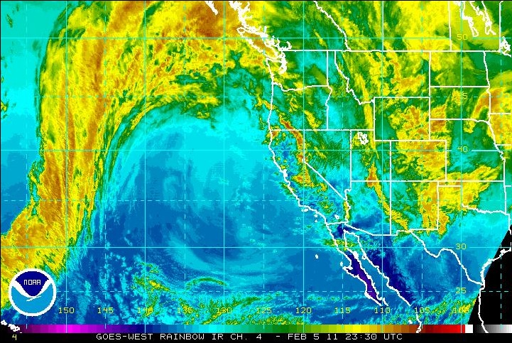 This will help us communicate important issues related to a current storm including links to NWS warnings along wtth images of current satellite and radar images. 2) New Storm Total Info on Home page, along with the Start date of a current storm. These stats will show up once measurable rain has been reported by the station and will remain visible as long as the rain continues. This will allow all of our weather bugs to keep an eye on the latest storm and track its total rainfall amounts! (Now all we need is a return of winter!) 3) Last day of rainfall with date and total. This unfortunately is going to be the most visible new bit of info on the home page, showing the last day we received any measurable rain at the station and how much we received total. This info will be visible whenever there is no precipitation currently being recorded at the station. (which is constantly at the moment!) We will be rolling out a few more additional features contained in R10 over the next week or two. In the meantime, we are starting to hear rumblings that a pattern change might be in the offing for our area around the middle of the month! Still too early for any real details, but there are some encouraging signs that the infernal high pressure ridge might finally be breaking down and getting the heck out of here! Stay tuned for more on that! [end of report] 31-Jan-2011, 08:55 Back to the Ridge... and DRY, DRY Weather. Another ridge of high pressure will build back into the area today and remain in place for at least the next 10 days. With February traditionally being our wettest month of the year, this re-emerging dry pattern is cause for concern, since our above average snow pack and rainfall totals will not last if high pressure and a northerly deflection of the winter storm track continues to dominate as it did through most of January. We can just keep our fingers crossed that a stronger pattern shift similar to what we saw on Sunday, only much larger takes hold before it is too late. April 1st is generally considered to be the end of the wet season for the Southern Sierra. [end of update] 30-Jan-2011, 12:28 STORM UPDATE: An impressive band of precipitation is now moving through the Bass Lake area bringing some VERY heavy snow to the station and the start of some measurable accumulation on the ground. The current temperature is once again down to 35 F from the pervious high of 38.2 F just after 11AM. The storm total now stands at 0.55 inches with an updated monthly total of 2.62 inches. We expect this pattern of rain bands followed by a few hours of lull, followed by another band, to continue through the day with a gradual tapering off by dusk. [end of update] 30-Jan-2011, 07:46 Very Welcome Rain and Snow Arrives Over the Station! We are pleased to report that although this low pressure system that is currently moving through our area is far from the usual strength we expect this time of year, it has managed to deliver some respectable precipitation this morning. We are observing moderate snowfall at the time of this report with a current temperature of 35 degrees F. Precipitation began just before 4:30AM this morning in the form of a rain/snow mix which persisted until 7:30AM. A complete transition over to snow then began and we are starting see see some accumulation on cars and other metal objects. Our current storm total stands at 0.32 inches with a current rain rate of 0.09 in/h. Rates have been as high as 0.25 in/h during the mix. Radar shows the current rain band about to clear the area, with additional smaller bands moving in off the coast and expected to bring additional light to moderate precipitation until this evening. The system is then expected to move out of the area with a return to mostly clear skies for Monday and a gradual rebuilding of the high pressure bubble we have been enduring these many dry weeks. Our current rainfall total for January 2010 stands at: 2.39 inches [end of report] 28-Jan-2011, 14:00 Brief Pattern Change for Saturday Night and Sunday The weather gods have decided to throw us a few crumbs in the way of some precipitation for this weekend. A low pressure trough will be descending out of the Gulf of Alaska with the southern tail of this system brushing the Central California area on Saturday night through Sunday night. Quantitative precipitation amounts for the Bass Lake area do not look very impressive at this point, but considering that we haven't seen a drop of rain since the 2nd, we will take whatever we can get! Snow levels are expected to stay above 4500 feet, but there could possibly be a lowering of that level to our elevation early Sunday morning depending on overall temps. Unfortunately, this storm system will not linger and is forecast to clear the area by Monday morning followed by a return to the high pressure ridging that we have been stuck with these many unseasonably warm and dry weeks. Nothing interesting in current model runs beyond this one isolated system well into the end of next week. [end of report] 22-Jan-2011, 11:46 Warm and Dry Pattern to Continue Indefinitely The strong La Nina pattern has certainly been making its presence known this month. Extended forecasts continue to paint the same unchanging weather picture well into February. The Rainfall total for the season to date continues to remain above normal, thanks to all of the above normal rainfall we received at the end of 2010. However, if this dry pattern continues past the first 7 days of February, then we will begin to enter a deficit for the 2010/2011 rainy season. The warm temperatures will also eventually begin to effect the Sierra snowpack with earlier than normal melting. So...We can expect the high pressure to continue for the foreseeable future with above normal temperatures and well below normal precipitation. Our current rainfall total for January stands at 2.06 inches which was all recorded the first two days of the month. With no rain expected through the 31st, this will make January 2011 the driest January on record for the region. The records go back to the late 1800s. [end of report] 15-Jan-2011, 10:46 La Nina Has Officially Arrived! Although all the usual indicators had been in place since mid-June, for some yet to be explained reason, it took until the end of the first week of January before the signature effects of El Nino's polar opposite began to take hold and started changing our normal winter weather pattern into a much warmer and dryer one. All of the hallmarks of La Nina are now revealing themselves on the west coast of the USA. The typical La Nina pattern brings about a radical, extreme northern shift in the jet stream and along with it, the path of winter storm systems moving in from the Pacific. Storm systems that would normally move into the central and southern California regions are shifted north into the Pacific Northwest, while points south of the Oregon border receive the rain shadow of all of these passing systems resulting in above normal temperatures and little to no precipitation. You can click on the WARNINGS link above to view the current IR Satellite image which currently shows a classic example of this northern shift in the storm track. The long range forecasts do not look good in terms of additional rainfall events for the remainder of the winter 2011 season for California. While we can expect to see a few wetter patterns briefly emerge between now and Spring of 2011, the overall expectation based on previous La Nina events is that from this point forward, our precipitation totals for the remaining months of the season will be far below normal, and warming temps will eventually impact the Sierra snow pack ahead of the normal Spring melt. It is VERY fortunate for Central California that we saw such ample rainfall ahead of this La Nina take-over which will help to temper what would have normally been a significant drought inducing pattern shift. This will likely be our last weather related update for the foreseeable future because the current weather pattern is expected to continue unchanged well into the end of this month and likely into February. [end of report] 13-Jan-2011, 12:17 Mostly Cloudy Today as System Passes to Our North / Fair Rest of Week The low pressure system that had originally been forecast for our area today is passing far to the north but will be providing clouds over the area from the edge of the front. It is expected to move through by tomorrow and this will allow the high pressure ridge to clear us out again with fair skies. There is a very good likelihood of dense fog in the lowlands through the weekend and into next week, but the Bass Lake area will see clear skies during this period. Extended forecast models are showing nothing in the way of storm systems for our area well into the 10 day runs, so it is looking pretty obvious at this point that the La Nina weather pattern has taken a firm hold of the jet stream and along with it, the winter storm track. February is traditionally the wettest month for our area, so it will be interesting to see what kind of storm activity we see come next month. It could very well turn out to be one of the driest Februarys on record. Based on current predictions and unless we see a change to a wetter pattern soon, January 2011 will go down in the record books as one of the driest in over a decade. [end of report] 12-Jan-2011, 17:24 Power Outage Takes Down Bass Lake and Station Uploads Due to some damaged equipment near the dam, we lost power just after 10:40AM this morning and power remained off for the entire Bass Lake area until just after 5PM. Although the station has battery backup, our cable internet service relies on power from the grid, so the station was unable to update any online sources until the main power came back on. Downtime time was just over 6 hours. No weather data was lost and all online sources have now been updated with data recorded during the outage. [end of report] 12-Jan-2011, 08:09 Fair/Dry Weather Dominates Through Middle of Next Week The station logged only 0.01 inches of precipitation all day yesterday from what proved to be an even weaker low pressure system than originally predicted. High pressure ridging is back once again and will dominate our local conditions for at least the next 5 days, with temps averaging a bit higher than seasonal norms. The storm track is well to our north and will remain so during this period. Fog will once again become a major issue in the lower elevations and in the SJ Valley. Long range forecasts see little change in this dry pattern, although there are a few indications that we may see another weak system brush the northern edge of the forecast area around the middle of next week. [end of report] 10-Jan-2011, 21:16 Cloudy with Light Showers Possible Tuesday thru Wednesday Morning The approaching system is not expected to provide us much in terms of rainfall totals. Temps are expected to moderate a bit towards a warmer trend, so the Bass Lake area will likely see rain and possibly a rain/snow mix as opposed to snow. Still, there is always the chance that the current cold temps will stick around long enough ahead of the front to allow for flurries Tuesday afternoon. In addition, the second system that was originally forecast to arrive on Thursday is no longer in the forecast. Instead we will see another high pressure ridge move into the area behind the Tuesday/Wednesday weak frontal system. Expect the ridge to remain in place from Thursday and remaining in place through the weekend. The pattern will be similar to the last 7 days with mostly clear and sunny conditions with highs in the upper 50s and lows in the 20s to low 30s. Long range models hint at the slight possibility of another weak low pressure system arriving over the forecast area by this time next week, but for now, it is too early to say whether or not a true pattern shift will take place at that time. La Nina May Be Starting to Moderate Storm Activity We are starting to see signs that the strong La Nina weather pattern that has been in place for the past six months is finally beginning to produce the predicted effect on our winter storm activity. A typical La Nina tends to force the jet stream far to our north and leave California with a much dryer winter weather pattern than normal. Daytime high temps may start to average about 5 degrees above normal for the given time of the year as well. The proof will come next month, as February is traditionally the wettest month of the season for the Southern Sierra. Fortunately, our seasonal precipitation totals and Sierra snowpack are both so healthy and so far above normal that we will be able to weather an extended dry spell much better than a typical La Nina winter. Still... For those who look forward to our winter storm season, the best of the season may already be behind us. :o( As always with the approach of any new weather system, be sure to click on our "Watches - Warnings - Links" button above for the latest regional weather news and advisories from The National Weather Service. You can also track the approaching storm using the IR Satellite imagery provided on that same page. We will update again within the next 24-48 hours with any precipitation totals we receive from this next storm. [end of report] 09-Jan-2011, 18:07 A Pattern Change in the Offing? The NWS is now predicting the possibility of some light rain/snow for the Bass Lake area on Tuesday as a shortwave trough moves in from the north. We will once again be on the edge of the snowline, so the precipitation could go either way in terms of rain or snow. A rain/snow mix is also a very likely possibility. The system will move through by mid-day Wednesday and then another system may be moving in on Thursday. Quantitative precipitation estimates remain on the light side for both systems, but the possibility for upslope induced heavier precipitation is always there when forecasting for the Sierra. We will update the journal again on Monday night or Tuesday morning as we learn more about the approaching systems and the potential for measurable precipitation from them. [end of report] 06-Jan-2011, 19:50 Fair and Dry Pattern Remains Through At Least Next Week If you are a fan of dynamic weather like we have seen in recent weeks, you are going to be pretty bored for the next 7-10 days. The current high pressure system that has brought us our fair and dry weather lately is expected to remain in place for at least another full week. Expect highs to remain in the mid to upper 50s with overnight lows in the high 20s to low 30s. Fog will remain a factor for lower elevations and the SJ Valley. There may be a few partly cloudy days coming up as some low pressure systems to our north brush the northern edges of our forecast area, but for the most part, what we have been seeing all this week will continue to dominate the Bass Lake area weather for the foreseeable future. This is more in keeping with the La Nina weather pattern that generally brings warmer and dryer weather during the winter months than normal. Fortunately this time around, we have had so much rain and snow that if we didn't get another drop of rain through April 1st, we would still pull out a normal seasonal total! This will probably be our last Journal update for a while since there won't be any noteworthy weather related information to write about. ;) As soon as we see signs of a pattern change back towards some wet and unsettled action, we will of course let everyone know. [end of report] 03-Jan-2011, 10:16 Gradual Clearing Today - Fair Weather Rest of the Week The low pressure system which has been spinning around over the area will be lowly exiting the area to the east throughout today. There is still a slight chance of some upslope generated rain and snow showers, but otherwise expect a gradual clearing and then mostly sunny conditions for Tuesday and the rest of this week. Models are still in disagreement as to when the next system will arrive. Accuweather is predicting another system to come through on Saturday, while the NWS is keeping the fair to partly cloudy conditions through the weekend. Here are some totals: Rainfall Total Yesterday: 1.67 inches Storm Total: 2.04 inches For the Month: 2.04 inches For the Season: 26.22 inches We will post another update later this week regarding the weather for the weekend. [end of report] 02-Jan-2011, 14:24 STORM UPDATE: 3:00 p.m. The temp has fallen to 34.3 degrees and the moderate to heavy snow has begun to stick. So far we have about 1/2 of an inch of accumulation on the ground. STORM UPDATE: 2:30 p.m. Snow has begun falling at the station although temps are far above what we normally see for snow to begin falling. The current temp is 37.8 whereas yesterday we were getting rain at 34 degrees! Very odd transitional temp swings to be sure. At this temperature, we won't be seeing any accumulation from what is currently a very heavy snowfall. Our current rainfall total is: 1.49 inches Storm total: 1.85 inches [end of update] 02-Jan-2011, 09:57 Steady Rain with More Expected Throughout the Day Moderate to heavy rain arrived over the station just before midnight last night and has continued through the morning. The station has logged 1.24 inches since midnight with rain rates averaging around 0.10 in/h. The NWS has issued several watches and warnings. Please check the link above for details. It appears that the precipitation is moderating right at the station's location with heavier rain just to the south and west of our location and lighter amounts to our north and east. Stations at higher elevations such as Fish Camp have reported far lower rain totals so far today. Temps continue to hover in the mid to upper 30s, so there has obviously been no chance for any snow with only a few periods of a rain/snow mix. The NWS is calling for this pattern to continue for our area through the day today with a gradual tapering off of the precipitation late tonight and into Monday. Current storm total: 1.60 inches In station maintenance news... We installed an intermediate update to our Weather Center software. The latest version is now V2.1 R9 build 953. [end of report] 01-Jan-2011, 21:37 Moderate to Heavy Rain/Snow Heading In! As of this report, there is a very large band of precipitation moving in from the coast. Current radar is showing the level of rain rate to be relatively heavy. Check out the "Watches" page linked above for the latest IR Sat image. This precipitation should begin arriving over our area within the next 2 hours or less. The problematic aspect with this particular storm is the transitional temp between rain and snow. Our automated rain/snow alerts have been getting fooled by this system all day today since we have been seeing rain with temps well within the range that would normally be delivering a mix or a full on snow event. Regardless of the transition temp issue we have seen during the day today, we are pretty sure that by early Sunday morning, the snow will finally arrive in the Bass Lake area and we will likely wake to some of the white stuff on the ground. The system is expected to hang around until late Sunday night with steady rain and snow tomorrow and will continue to bring a 20% chance of rain/snow showers Monday. Current rainfall total: 0.28 inches Current Temp: 35 degrees F [end of report] 01-Jan-2011, 11:52 Rain/Snow For Today with More on Sunday The first half of the next low pressure system has arrived over the area bringing a rain/snow mix to the Bass Lake area at temperatures that usually result in pure snowfall. The reason for this is because this system is pulling in moisture from the south which is mixing with the cold front. This is causing the precipitation to fall as much warmer rainfall at high altitude and thus, the surface temps are not having as much effect on the type of precipitation that makes it to the ground. Current rain total for today stands at: 0.10 inches with a light rain/snow mix. The forecast is calling for light to moderate rain/snow to continue on and off today with increasing rain rates later this evening and through Sunday. The latest models are indicating some significant precipitation totals for our area tomorrow, with current estimates ranging as high as 2 inches of rain, and 12-15 inches of snow depending on altitude. Snow levels are expected to fall later this evening and into Sunday morning, so we are expecting some accumulation at some point over the next 24 hours. We will update the journal again later today as we gain more forecast information. Be sure to check the watches and warnings page for the latest alerts from the National Weather Service. [end of report] 31-Dec-2010, 16:48 Light to Moderate Rain/Snow Arriving After Midnight The next system to come into California from the pacific will be entering our forecast area within the next few hours, with rain and snow moving into the area just after midnight. This system will be nothing like what we have seen over the last few weeks, but our temperatures will be low enough for Bass Lake to see this precipitation arrive in the form of snow flurries and moderate snowfall rather than rain. We expect to see overnight lows well into the 20s again this evening, so if you have any New Year's Eve plans tonight, be sure to drive carefully. There is likely to be a good deal of slick roads out there and more hazardous driving conditions once the snow starts to arrive. Happy New Year Everyone! [end of report] 31-Dec-2010, 11:45 Station Software Maintenance Report - NOAA Radio Transmitter Issues We have just installed the latest development version of LWC 2.1. (R9 Build 944) This new version provides more detail for the Solar Radiation graph output, some performance improvements and additional minor tweaks to various data output threads. R9 also introduces a banner graphic generator that can provide current weather data within a 500x80 pixel signature graphic. This can be used as part of an email signature, or on a web forum or blog. We created a banner and have added it to our LWC forums account. Working well so far. Facebook currently does not provide the ability to add a signature banner graphic to their message system, so most of our readers will probably never see this graphic in action. NOAA Weather Radio Broadcast Issues We also wanted to report that the KIH-62 Weather Broadcast transmitter appears to be running at a very low output power today. Our radio can barely pull in the signal and although you can hear the reports, they are buried in static. We assume that Hanford is performing maintenance of the transmitter for some reason and have reduced the output power during the procedure. Have added an alert to the home page regarding the issue. Hanford has been contacted and we will have to wait and see how long the problem lasts. NOTE: We will post a weather related update later this evening as soon as we get the overnight forecast information from Hanford. [end of maintenance update] 30-Dec-2010, 09:37 Clear and COLD - More Rain/Snow Possible This Weekend The system exited the area a little faster than the NWS had predicted leaving us with clear skies this morning. As a result, overnight temps dropped sharply and gave us an overnight low of 19.8 F which is one of the colder overnights we have seen in some time. There is still the possibility of upslope cloud formation later today as the atmosphere heats up, so we could see partly cloudy or even mostly cloudy conditions later this afternoon. Another system is moving in off the Pacific from the northwest and should start to bring high clouds and later cloudy skies to the area later tomorrow. (Click on the WATCHES - WARNINGS - LINKS button to view the latest West Coast SAT image from NOAA) The current NWS forecast is calling for this system to arrive over the area late on New Year's Eve and settle in over the area on New Year's Day through Sunday. Precipitation amounts are still uncertain at this time, but there is a good chance we will see some rain or snow showers during the day Saturday and very likely through Monday. Currently the probability estimates are 20% Friday night and 40% on Saturday and Sunday. Daytime highs will remain very cold and overnight lows will likely remain in the 20s to low 30s. The more overcast we see over the area the higher the overnight low temperatures will be. We will update the journal tomorrow night or early Saturday depending on conditions. We would like to wish all of our regular visitors a very enjoyable New Year's Eve and New Year's Day! Be careful out on the roads after dark! The risk of black ice during conditions like we will be experiencing this weekend is VERY high! [end of report] 29-Dec-2010, 19:44 Storm Wrap-Up - Hard Freeze Tonight! The system has moved out of the area leaving some remaining unstable and COLD air in its wake. There is still a 50% chance of snow showers through the remainder of the evening and into Thursday morning. Temperatures have fallen considerably over the last several hours with the current temperature hovering at 31 degrees F. A hard freeze is likely overnight, so all standing water and snow accumulation is going to freeze solid. Roads and other surfaces will be extremely slick come the morning, so use caution when leaving for work or other activities that involve walking/driving on pavement or cement surfaces. Here is the latest rainfall totals as of this report: Total Rainfall Today: 1.16 inches Storm Total: 2.38 inches For the Month: 13.33 inches For the Season: 24.17 inches The revised forecast for Thursday calls for mostly cloudy skies with a 50% of snow showers. Friday is still expected to be mostly sunny but VERY cold. OVernight lows are likely to drop into the low 20s and possibly into the mid-teens by daybreak tomorrow. Another system is still expected to brush the area on New Years Day and Sunday with some isolated rain and snow showers predicted for the Bass Lake area. [end of report] 29-Dec-2010, 13:16 Falling Temperatures and Continuing Upslope Precipitation = SNOW! Temps have fallen rather quickly over the last 30 minutes and mixed with the current upslope precipitation, snow is now falling at the station. 29-Dec-2010, 09:34 Storm Update: 12:45 P.M. A stable upslope condition has settled in over the station proving us with a steady light rain that has persisted for the last several hours. This has managed to push our rainfall total for the day up beyond another 10th of an inch to 1.03 inches for the day so far. Also have seen some low clouds and fog move in and out of the area within the last 30 minutes. The extended forecast is still on track for a gradual clearing into Thursday with colder temps and overnight lows possibly getting as low as the 20s by Friday. [end of update] STORM UPDATE The storm definitely wasn't as nasty as we were expecting. The rain intensity was also very localized due to some interesting upslope behavior. Stations just 5 miles south west and west of our location such as Oakhurst and North Fork received considerably more rain than we did. Fish Camp had much less rain than what was reported by our station, which is just the opposite of what we normally see. The transition temperature for rain to snow was also not where it normally is, so although we saw some very heavy snowfall in the early morning hours, there was zero accumulation and by daybreak, the precipitation was back to a rain/snow mix and then back to all rain by sunrise. Interestingly, we were seeing temperatures between 34 and 37 degrees with all rain! Normally, we would have seen a heavy mix or all snow at these temperatures. Still getting some upslope showers here, but the main rain bands have moved far south of our location this morning. Here are our stats: Current Today: 0.89 inches Storm Total: 2.11 inches For the Month: 13.06 inches For the Season: 23.09 inches The high winds forecast for the lower Sierra never arrived so we didn't have any significant wind gust data through the entire event. The system has moved south and into Southern California this morning and this will unfortunately bring more flooding to an already saturated area. We can expect occasional upslope generate showers today with perhaps a few more 100ths of an inch added to today's rain total. Temps will remain in the high 30s to low 40s with gradual clearing. Thursday and Friday look to be clear to partly cloudy, and then another system will brush by the area for the weekend. Models are still in disagreement as to how much precipitation we will see from this first storm of 2011. We will need a few more days of data before we will be able to make a more specific prediction. [end of update] 29-Dec-2010, 01:37 STORM UPDATE The station recorded a total of 1.22 inches of rain on the 28th with moderate to heavy precipitation continuing into early Wednesday morning. The precipitation is transitioning over to snow at this moment with a current temp of 35.5 F. The upslope characteristics of the system tonight has created heavier rain west of the station bringing moderately higher rainfall amounts to Oakhurst and Northfork than to the Bass Lake area. The first major band of precipitation is nearly through the area as of this update, but colder air and more precipitation is expected for the better part of Wednesday. Because temperatures remained far above the rain to snow transition point through the bulk of the heaviest precipitation last night, the amount of snow accumulation around the Bass Lake area will likely be much less than originally predicted by the NWS. Additionally, the high winds that had been forecast have not materialized, which based on current ground saturation is very welcome news! [end of update] 28-Dec-2010, 19:20 Precipitation UPDATE: 10:04 PM Current Rainfall Total Now: 0.90 in with moderate rain rate. Temperature stable at 40.7 F. STORM UPDATE: Steady Rain Since 3:30PM The storm has moved in and been providing a steady rain ever since. Current total stands at 0.39 inches with an average rain rate of 0.12 in/h. The rates do appear to be picking up as of this update and radar shows that the colder portion of the system has yet to arrive. The temperature has been holding steady at 42 degrees for the last two hours, but we fully expect that to change soon and when it does, the rain will begin to transition over to snow. So far, the predicted high winds have not materialized, which is great news! We will update one more time tonight as soon as that transition takes place. [end of report] 28-Dec-2010, 11:26 Precipitation Slowly Moving In From the North The latest NextRad radar is showing a large precipitation band moving down the state from the north. Forecast estimates are still on track for the main part of the storm to arrive over the Bass Lake area by late this afternoon into early evening. With temperatures currently in the mid-forties, it remains likely that when the precipitation gets here it may fall as a rain/snow mix, transitioning over to all snow by later this evening. Models are indicating the potential for as much as 12 inches of snow accumulation at 4000 feet, which would likely result in close to this amount here at the station and the rest of the Bass Lake area. Precipitation is expected to remain moderate to heavy throughout tonight and well into Wednesday. The National Weather Service has issued multiple flood watches and warnings for the lower elevations of the Sierra and in the SJ Valley. You can now monitor our area's latest watches and warnings using the new link button at the top left of the Journal text window. As always, we will update the Journal again later today as soon as we begin to see the direct effects of the approaching system. [end of report] 27-Dec-2010, 20:18 JOURNAL PAGE UPDATE: We have added a new link button above that will take you to a new page on our site containing storm tracking links. These include the NWS Watches and Warnings page for Bass Lake, and the latest IR Pacific Satellite Image from NOAA. We will have a more detailed journal entry on the approaching winter storm later today. [end of update] 27-Dec-2010, 08:25 Major Storm Arrives Tuesday Night - Wednesday Morning Fair weather will preside over the area today and most of the day tomorrow before the next pacific storm moves into California. The most recent model runs are alarming as to the severity of the approaching storm. Not only are the quantitative precipitation amounts VERY high, there is the potential for some VERY HIGH WINDS! While we are usually spared wind storms of the "Mono Wind" variety, the NWS is suggesting that the Bass Lake area could be hit by sustained winds upwards of 40 mph with gusts approaching 60 mph! This kind of situation would be of major concern under normal circumstances, but considering how saturated the ground is from all the recent rains, the chances are good that we could see some serious property damage and power outages as a result of downed trees and power lines. Residents will need to be especially vigilant to identify trees around their property that could fall on or near their homes should these high winds arrive as forecast. Snow levels will lower to near 4000 feet later in the day and into the evening hours. Potential for significant accumulation if conditions are right. If high winds continue, blizzard conditions could result. The forecast then is as follows: Today: Clear and dry with some upslope cloud formation. Overnight low below freezing. Tuesday: Clear and sunny through most of the day with increasing clouds. Continued cold nights. Tuesday Night: Cloudy with increasing chance of rain early, then rain through the night, heavy at times, possibly switching over to snow. Wednesday: Rain/snow and high winds through the day and most of the night. Snow level will be near 4000 feet so snow likely. Thursday: System begins to exit the area. Mostly cloudy during the day with chance of snow continuing. We hope that you see the dangers that could present themselves if the forecasted conditions come to pass. This next storm has the potential to be the truly first major SNOW storm we have seen so far this season, and quite possibly a record breaking one in terms of precipitation amounts, wind speeds and snow accumulation. It is highly advisable that all Bass Lake residents pay close attention to the latest NWS forecasts leading into Tuesday night/Wednesday morning, and monitor our station web site for the latest forecast information and real-time condition alerts via our home page. [end of report] 26-Dec-2010, 08:18 Unexpected Snow for Bass Lake Although snow levels were predicted to remain above 6000 feet during last night's rain event, temperatures began falling rapidly just after 9:30 p.m. and a rain/snow mix developed. This was replaced about 30 minutes later with a moderate snowfall that lasted for the next two hours. Total snow accumulation stands at 3 inches with the current temperature of 32.6 degrees. We received a total precipitation amount of 0.97 in before midnight with an additional 0.08 after midnight. Things should be clear and sunny today and Monday before another system begins to move in on Tuesday. Locally dense fog will be possible in some areas this morning and Monday morning, with heavier fog at lower elevations. Our storm total was: 1.05 inches. NOTE: We received a few more emails this morning from users who noticed a somewhat large difference between our storm total and that "other" station here at Bass Lake. Please check out our ABOUT THE STATION section of our website for a link to a new Q&A page we recently created. It addresses the primary causes of this continuing discrepancy between our station's rainfall totals and that other station. In short, until that other site's operator corrects some glaring issues with their current siting location, that station will continue to over-report rainfall totals due to excess water entering their rain bucket from nearby pine trees. This problem is exacerbated during high wind events accompanied by heavy rain. Once snow begins falling, their totals tend to stay in line with ours, however, if the precipitation begins as rain and later transitions to snow, the ultimate totals will remain off by significant amounts. All of our users can rest easy in the knowledge that the rainfall totals reported by our station ARE ACCURATE and untainted by an improper station installation. [end of report] 25-Dec-2010, 08:48 MERRY CHRISTMAS! The next pacific storm system is hovering just off the California coast and will be pushing east into the area today. Expect rain to arrive in the Bass Lake area just after sunset and continuing through the night. Precipitation should subside by early morning on Sunday with gradually clearing skies throughout the day tomorrow. The system is a very fast mover, so it is not expected to remain over the area for long, and thus total precipitation amounts will be nothing like what we saw last weekend. As usual, the low pressure system is rotating in a counter-clockwise direction, so those taking advantage of our Wide Angle Precipitation map to track the rain will notice that the rain bands will be moving from south to north as long as the east side of the rotation effects our area. Late tonight the movement will reverse to a north to south direction as the west side of the rotation moves over us. Precipitation estimates predict that the Southern Sierra will receive between 0.50 to 2.00 inches from this system depending on location and topographic influences. Snow levels are expected to remain above 6000 feet during most of this event, with a slight chance of some flurries in our area near dawn as snow levels lower to about 4500 feet. Because the precipitation will be tapering off around this same time, accumulations for Bass Lake are not expected. After this system moves through, we will have about 48 hours to catch our breath before yet another pacific cold front moves in on Tuesday. This next system originates in the Gulf of Alaska and will be pulling cold air down from Canada, so the snow levels will be much lower than today's system and might provide us with some measurable snow accumulations around Bass Lake Tuesday night and through Wednesday. NOTABLE RAINFALL MILESTONE! We also wanted to mention that we have broken our previous record for the most rainfall in a single month. The previous record was set back in January of this year with 9.58 inches. Our current monthly rainfall total for December 2010 stands at 9.89 inches! That is a heck of a lot of rain and the month isn't over yet! With the system tonight and another mid-week, we fully expect to end the month at well over 10 inches for December. This also shatters last year's December total of 8.41 inches. As you may already know, we are currently in one of the strongest La Lina patterns in decades, so rainfall totals like this are unheard of during this kind of pattern. Most climatologists are suggesting that the effects of Global Warming are to blame for changing the rules over what we have come to consider a very predictable result from both La Nina and El Nino weather patterns. You can expect another journal update tonight when the precipitation from this current system begins to arrive over the station. Once again we wanted to wish everyone a very enjoyable holiday weekend! [end of report] 22-Dec-2010, 17:04 Historic Weather System Ends With a Whimper Rainfall totals today fell far short of what had been predicted with only 0.44 inches being recorded by the station since midnight. Radar returns are showing little potential for any additional precipitation tonight, so we are going to call this one done! If you have been checking the local and national news, you have no doubt seen that this historic weather event was one of the top stories even on CNN! The Bass Lake area was fortunate in that we didn't suffer from heavy flooding, mudslides and all the other nasty things that befell residents in low lying communities in other parts of the state. As we mentioned in several previous reports, Thursday and Friday should be dry and mostly sunny as the remnants of this final system move out to the east. Temperatures will remain on the cold side however with the potential for frost and freeze warnings to be issued by the station the next few nights. Christmas day should be dry until late afternoon when another weak trough of low pressure moves into the area bringing the threat of showers and possible light snow to the area through Sunday morning. This system should blow out by Sunday night where we will see a return to high pressure and partly cloudy to mostly sunny skies for the early part of next week. Our storm total to date stands at: 7.46 inches We will probably not be posting another update until late on Christmas day or whenever we see some measurable rain to report. We would like to wish all of our users a very Merry Christmas and Happy Holidays! [end of report] 22-Dec-2010, 09:39 STORM UPDATE: Scattered Showers / No Snow The rain bands we were tracking earlier this morning finally moved into the area just after 4AM this morning with light to moderate showers over Bass Lake for the last several hours. Temperatures are stable in the low 40s, so we don't anticipate any snow from this system today. Possibly a few flurries after sunset. * The track remains south to north as we are still under the influence of the eastern edge of the low pressure circulation. We don't anticipate that this system will be capable of producing the levels of heavy rain that we have been seeing since Friday. The current conditions are expected to continue through tonight until the system exits to the east, replaced with with partly cloudy to mostly sunny skies on Thursday and remaining in place until late Friday night. At that point another weak shortwave trough will move in off the pacific giving us yet another chance of rain Christmas night into Sunday. Here are some current stats: Temperature: 42F Humidity: 96% Dew Point: 40.9 F Rainfall total: 0.30 inches with steady rain. (Rain Rate 0.06 in/h) * If we see a dramatic drop in temperatures between now and our next scheduled update, we will post a special update here at that time. [end of update] 22-Dec-2010, 01:34 STORM UPDATE: Early Wednesday Morning The rain bands from the Alaskan Low pressure system are gradually moving into Central California via Southern California as of this report. The system has slowed its travel a bit since early evening yesterday which has delayed the arrival of the primary waves of precipitation. However, radar is showing significant returns in three solid and well organized rain bands. There is a rather large gap between the western most band over the Bay Area and the center band currently over the Palmdale area. Hopefully the eastward movement coupled with the south to north rotation will prevent Bass Lake for being caught in the gap between rain bands. That would mean a lot of wind and no rain. Based on current speed and circulation and assuming the gap closes or misses us, we are now estimating that the heavy rain will be arriving just before dawn and should continue at least until noon. Additional rain bands are expected to follow this initial wave through most of the day Wednesday. The other variable continues to be the snow level. The western side of the circulation is very cold, so depending on when that portion of the system moves over the Sierra will determine whether Bass Lake will see a transition from rain over to snow at some point. The current temperature at the station has been steady at 40 degrees F for the last 4 hours, so no chance of snow during this first wave. We just had our first bucket tip for today as this report was being prepared, so our current rainfall total for 12/22/10 stands at 0.01 inches with currently light drizzle and mist. [end of update] 21-Dec-2010, 18:30 STORM UPDATE: Tuesday Night/Wednesday The infamous Alaskan Low Pressure Vortex that helped drive this historic weather pattern since the 17th is appropriately going to be the last of the storm systems in this series to move into California later tonight. The center of the low is now just off the coast of Eureka Ca. and moving south. The low is rotating in the typical counter-clockwise direction, so the rain bands will be moving up from the south as they head north around the eastern edge of the circulation. The next wave of significant precipitation for the Bass Lake area is expected to arrive late tonight and continue to effect the area through all of Wednesday. Current radar returns show a clear track out to the coast with the first detectable rain bands destined for our area just now coming into the radar sweeps over the Ventura county coastline. The system is moving at a respectable speed so these bands should arrive here over the next 6-8 hours. Showers should begin sometime after 10PM from the fringe of the first moisture band, with heavier rain arriving after midnight. Snow levels are hovering close to our elevation, so there is a possibility that the earlier showers could give way to a rain/snow mix turning to moderate to heavy snowfall later. Stay tuned to our web site and specifically our "Wide Angle Precipitation Map" so you can follow the progression of the rain bands in nearly real time! The link to this map becomes available on the first tip of the rain bucket. Fans of this customized rain tracking system are encouraged to bookmark it, so it can be called upon any time you want! It also comes in handy for checking on FOG conditions in the SJ Valley in the Spring and Fall. [end of update] 21-Dec-2010, 10:54 Mostly Cloudy Today with 50% Chance of Showers Tonight A slight change in the two day forecast today. The next system is now predicted to move into the area late tonight with increasing chances of showers through tonight. Rain is expected for Wednesday through Wednesday night with the possibility of some isolated Thunderstorms in the SJ Valley as well as the Sierra foothills. Snow levels are currently expected to remain above the Bass Lake area on Wednesday, but there is always the chance that the levels could lower and bring us some rain/snow mixing or full on snow by Wednesday night. As always, use caution if venturing out on the local roads tonight and through Wednesday. The long range forecast calls for partly cloudy to mostly sunny and dry conditions for Thursday and Friday with another chance of rain on Christmas day through Sunday. We will update the journal again once we begin receiving some measurable precipitation at the station. Here are the latest totals: Rainfall total for today: 0.02 in Rainfall total for yesterday: 0.80 in Storm total since Friday: 7.00 in Rainfall total for the month: 9.42 in Grand total for the season: 20.26 in [end of report] 20-Dec-2010, 20:31 STORM UPDATE @ 8:30 PM The huge subtropical moisture plume that had been providing all of our precipitation for the last four days began to shift south of our area late this afternoon with all precipitation dissipating rapidly soon after. The snowfall has completely stopped as of this storm update. While we may see a few scattered snow showers through the remainder of this evening, for all intents and purposes, one of the largest rain events to hit the Sierra in over a decade has rather undramatically come to an end. However, the center of the Alaskan low pressure system that has been pulling in that moisture plume will itself begin moving onshore and into the Bass Lake area over the next 24 hours. We can expect things to remain dry during most of Tuesday morning ahead of this next system. The current forecast is calling for precipitation to once again blanket our forecast area later in the day on Tuesday and continue to bring some potentially heavy precipitation well into Wednesday. Temperatures will remain low behind the current cold front, so most likely, this next system's precipitation will fall in the form of snow with the potential for some significant accumulation Tuesday night through Wednesday. After this system exits the area late on Wednesday, weather models are indicating that a medium strength high pressure ridge will build over the area for Thursday and Friday bringing partly cloudy skies and dry conditions before yet another pacific storm system arrives late on Christmas day for another round of unsettled and most likely WET or SNOWY weather. Here are the latest storm totals from the station's rain gauge: Rainfall total for today: 0.78 in Storm total since Friday: 6.96 in Rainfall total for the month: 9.38 in Grand total for the season: 20.22 in Total snow accumulation: 2.75 inches We will plan to post our next journal report sometime tomorrow after the next system has moved in and we begin to see some measurable precipitation. [end of update] 20-Dec-2010, 15:09 STORM UPDATE @ 3:09 p.m. Moderate snow continues to fall at the station this afternoon as temps hover just above the freezing mark. We are currently sitting at 34.3 degrees F. Here are the latest rainfall totals as of 3:00PM Our rainfall total for today primarily from snow melt stands at: 0.69 inches. Our current storm total since Friday stands at: 6.87 inches For the month we now have: 9.29 inches which is getting close to breaking our all time high monthly rain total of 9.58 inches set back in January of this year. Total for the season now stands at: 20.13 inches Total snow accumulation is currently just under 3 inches of heavy wet slush. For this evening, the forecast calls for continuing steady precipitation that based on current temps will likely continue to fall as snow. If we can get a few degrees colder after dusk, our snow accumulations will likely begin to increase since currently, we are seeing a good deal of the accumulation melting away soon after it hits the ground. Finally, a reminder that the region wide Flood Warning continues until Tuesday morning unless it is adjusted by the NWS either ending it early or extending it into Wednesday. All depends on the behavior of the storm track in the next 12-24 hours. We plan to post another storm update this evening before midnight to recap all the totals and review the forecast. [end of update] 20-Dec-2010, 11:46 Light to Moderate Snowfall Continues Temps have remained just above the freezing mark over night with a steady light to moderate snowfall. We currently have about 2 inches of slushy accumulation with the chance of the snow turning back to rain for a few hours before temps fall again. And now for something completely different... Weather Station Related Q&A "Talking Shop... Rain Totals Here and Over There" We have received some emails during this stormy weekend from a few users wondering why the rainfall totals from our station are so much lower than that "other" Bass Lake weather station's totals on the web. Which one is correct? How can two stations less than 1 mile apart be reporting such different 24 hour rainfall totals? Well... The short answer is that a 0.50 in or more difference in 24 hour rainfall totals between two stations .07 miles apart is highly unlikely to be caused by natural fluctuations in topological rainfall differences. The more plausible explanation (if the lower reporting station's data is known to be accurate and supported by other surrounding stations in the area) is that the station with the higher total has seen its rainfall data compromised by structure or obstacle induced "run-off". In this case, the "other" station's installation location is surrounded by very tall wind blocking pine trees while the weather station's data sensor array is mounted on the roof of a two story structure. During periods of heavy precipitation accompanied by wind gusts as low as 1-3 mph, the nearby pine trees become saturated with moisture which is then blown off the trees by the motion of the wind and directly into the roof mounted rain collection bucket. It would only take a few instances of this type of contamination to account for errors as high as 1.5 inches per 24 hours. This is why the NWS and CWOP provide new weather station operators with a comprehensive sensor siting guide designed to prevent situations such as the one described above from occurring. The NWS and CWOP weather station siting guide specifically calls for the station sensor array to be mounted 5.5 feet above natural ground cover, in an open space at least 150 feet away from any tall trees, structures or other obstacles above the height of the rain bucket that can block wind circulation and/or interfere with accurate rainfall collection. (D2149 has followed these guidelines to the letter) This is the primary reason that the NWS did not use the weather data from this other station on their radio broadcasts or compile archival weather data reported from it for so many years. It was not until D2149 was made operational in 2009 and its data was found to be up to the accuracy standards of the NWS that weather data from D2149 was made available on the Hanford NOAA weather radio broadcasts and included in the regional database for Bass Lake Ca. You could say that all of these problems had a lot to do with our decision to install our station in the first place. We were tired of not knowing the real numbers and seeing Bass Lake excluded from all the official modern weather records for the area. So... If you want to know what the rainfall total for Bass Lake was yesterday, you probably don't want to get your data from that "other" web site. Those who do, are getting highly erroneous rainfall totals. Especially on days with heavy rain and a lot of wind. ;o) For the "real" story on any given weather day, D2149 should be your choice. It isn't the "Official NWS Reporting Station for Bass Lake Ca." for nothing! ;o) [end of discussion] 20-Dec-2010, 00:02 STORM UPDATE: 12:02AM --- SNOW Falling at the Station! Temperatures have really fallen this evening as the edge of the cold front from the spinning low moved into our area. Apparently so much so that the rain is turning over to snow at the time of this report. The current temp is 36 degrees F and falling. If the precipitation continues, we could actually see some accumulation overnight. This was totally unexpected for tonight, so it came as a surprise when our rain bucket heater kicked on as it does automatically when the temperature falls below 37 degrees with rain being recorded by the rain gauge! There had been some speculation that we could see snow levels fall below 4500 feet on Monday night, but not until then! This storm system continues to impress and surprise us! :o) [end of update] 19-Dec-2010, 15:52 STORM UPDATE: Heavy Rain and Strong Winds Pound the Station! Over the last hour we have been observing some very intense cells of heavy rain with strong gusty winds moving through the area. As of this update we are seeing rain rates exceeding 1 inch per hour. 1.45 in/h was recorded at 3:49 p.m. The radar returns are showing more isolated cells moving through now rather than a solid mass of precipitation. However, these cells contain a great deal of unstable, moisture laden energy, so the chances for additional heavy rain and flooding continue as we approach sunset. There may even be a few isolated Thunderstorms contained in the approaching cells. Here are our current totals: For today: 1.45 inches Storm Total: 5.96 inches (Since Friday) For the Month: 8.38 inches For the Season: 19.22 inches Just a reminder that the area wide Flood Warning remains in effect through Tuesday morning. Additional heavy rain is expected through this evening and well into Monday. [end of update] 19-Dec-2010, 11:16 Flood Warning Statement Issued by The National Weather Service Hanford Ca. Statement as of 10:40 AM PST on December 19, 2010 ... The Flood Warning remains in effect until 815 am PST Tuesday for the central and southern San Joaquin Valley and adjacent foothills... and the southern Sierra Nevada and Tehachapi Mountains below 6000 feet. The small stream Flood Advisory remains in effect until 9 am PST Monday for the Kern County deserts. At 1035 am PST National Weather Service radar indicated moderate rain... with embedded areas of heavy rain... was continuing to move into the central California interior. The California Highway patrol had several reports of Road flooding in the central and southern San Joaquin Valley and the foothills. Rain will continue to move into the Kern County deserts through the afternoon and through tonight. Recent heavy rain has contributed to ongoing flooding conditions throughout the foothills and the central and southern San Joaquin Valley. Additional rain today through Monday night will aggravate flooding problems in these areas and will pose a continued threat of rising water through early Tuesday morning. Runoff in the Kern County deserts will cause some Road flooding and rises or flooding of small streams... arroyos and dry washes. Additionally... the threat of rock slides and debris flow will continue over the higher elevations and in the recent burn areas. The National Weather Service in Hanford is forecasting up to inch of additional rain in the San Joaquin Valley... with as much as 3 inches in the foothills. A Flood Warning means that flooding is imminent or has been reported. Stream rises will be slow and flash flooding is not expected. However... all interested parties should take necessary precautions immediately. Precautionary/preparedness actions... Most flood deaths occur in automobiles. Never drive your vehicle into areas where the water covers the roadway. Flood waters are usually deeper than they appear. Just one foot of flowing water is powerful enough to sweep vehicles off the Road. When encountering flooded roads make the smart choice... turn around... dont drown. Excessive runoff from heavy rainfall will cause flooding of small creeks and streams... highways and underpasses. Additionally... country roads and farmlands along the banks of creeks... streams and other low lying areas are subject to flooding. To report flooding... have the nearest law enforcement agency relay your report to the National Weather Service forecast office. Lat... Lon 3741 12086 3763 12021 3686 11908 3534 11845 3515 11860 3504 11936 3540 11981 3611 12047 3650 12057 3713 12114 Sanger 19-Dec-2010, 08:50 More Heavy Rain Today - Flood Warning Issued for All Areas! Update: 9:23AM The NWS has just issued a Flood Warning for all areas of the Sierra Nevada including the foothills. This warning actually includes the entire Hanford forecast area which includes all portions of the SJ Valley. The warning is in effect until 8:15 AM Tuesday. Previous report... We ended the day yesterday with 2.02 inches. A good chunk of that came down after 9PM last night when the plume once again shifted back up to the northern portions of the state. Today has already provided a good deal of additional rain with 0.81 in the bucket since midnight. Over the last hour, BAss Lake has been in a gap between rain bands so the rain activity has diminished to a very light drizzle. However, the next rain band containing moderate to heavy precipitation is just about to move over the station, so the rain intensity will begin to increase over the next 30 minutes. This will be the rainfall scenario throughout the day today. The Sierra Flood Advisory remains in effect at this time for all areas below 7000 feet including the foothills. Our current storm total since Friday stands at: 5.32 inches. Some stations in the back country of the Sierra such as Fish Camp are reporting some IMPRESSIVE totals. Fish camp had over 4.50 inches yesterday alone! This heavy rain is expected to continue on and off through Wednesday and then a weak ridge builds into the area with yet another chance of rain on Christmas day. There is the potential for snow levels to lower Tuesday night and into Wednesday which might give us a slight chance for snow during this 48 hour period. ? We will post a storm update this afternoon with the latest rainfall totals for the month and the season. [end of update] 18-Dec-2010, 16:23 STORM UPDATE: 4:25PM The current track of the center of the moisture plume off the pacific has shifted south today giving our area a bit of a break from the heavy rainfall through most of the day. Upslope showers, light rain and drizzle has continued to keep our area wet and slowly add to our daily rainfall total which currently stands at 1.29 inches. The latest SAT images indicate that another wave of heavy moisture is indeed on its way into our area and should arrive later this evening. This rain band is not yet within radar range so those checking the situation on the Precipitation Map page will not yet be seeing this next round of precipitation. Meanwhile, Southern California has been enjoying a great deal of heavy rain all day today due to the southern shift in the current storm track I mentioned above. This rain activity should continue for that area through tonight and into Sunday. So... While things are currently on the quiet side around our area, don't let the current lull fool you into thinking that the show is over. We fully expect to be once again seeing heavy rain before the day is over and continuing into Sunday. Remember that the local flood advisory for our area remains in effect through Sunday morning until further notice. [end of update] 18-Dec-2010, 07:41 STORM UPDATE: 11:15AM The NWS has extended the flood watch for the Sierra below 7000 feet until 9AM Sunday. The latest radar returns are showing that the bulk of the heavy rain bands have moved east and past the station at the time of this report. We are continuing to see a light drizzle due to continuing upslope activity. Based on the wide angle precipitation map results, it doesn't look like we will be seeing any additional heavy rainfall for at least the next 3-5 hours. The forecast for the area is still calling for heavy rain through Sunday, we fully expect additional rain bands to begin appearing at the coast as soon as the next wave moves into the radar coverage area. Our current rainfall total for today stands at 1.07 inches with a current rain rate of 0.04 in/h. This light rain/drizzle has been steady and is expected to continue until the next significant moisture bands arrive as indicated above. [end of update] Previous report... Rain, Heavy At Times Continues Today The series of storms that arrived over the area yesterday continues to dump large amounts of rain over the Bass Lake area. At the time of this report we are already up to 0.83 in for the day. Radar shows a strong upslope effect over the Sierra foothills extending east up to our area. Snow levels remain high, above 7000 feet. Not sure if the NWS will cancel of extend the small stream flood advisory for the Sierra below 7000 feet. It is set to expire at 9AM. Our rain total for yesterday was an impressive 2.49 inches. Here are our rainfall totals as of this morning's report: For the month: 5.75 in For the Season: 16.59 Check our home page for the latest real time weather conditions including current rainfall activity. Our Wide Angle Precipitation Map will give you the latest radar tracking information for storm activity moving into our area. [end of report] 17-Dec-2010, 22:05 STORM UPDATE: 10:05PM Over 2 inches of Rain So Far Today! The station rain gauge past the 2 inch mark just after 9:30PM this evening as heavy rain continues to fall over Bass Lake. As of this update the rain total stands at 2.11 inches with a rain rate of 0.30 in/h. The rain rate average since 6PM has been very impressive with the current 3 hour average of 0.32 in/h, with occasional rates over 1.00 in/h. The forecast is still on track for this rain to continue at the current intensity through midnight, with a break in the action around 1AM or so. The next wave of precipitation is predicted to move into the area around sunrise Saturday, with another round of heavy rain and high rain rates through the day and continuing into Sunday. The Flood Advisory for the Southern Sierra below 7000 feet including the foothills remains in effect, so those living near a river or stream should remain vigilant through tomorrow morning to monitor for potential flooding in their area. Long term forecasts are currently calling for this wet pattern to continue through Wednesday, with periods of heavy rain punctuated by several hours of drizzle and light rain as the various waves of moisture contained in the sub-tropical moisture plume continue to move in off the pacific. We will post a new journal entry tomorrow to document the rain events for Saturday and also update our monthly and seasonal rain totals. So far, a VERY impressive weather system! [end of update] 17-Dec-2010, 17:49 STORM UPDATE: 5:50PM Heavy Rain Has Arrived! The steady rainfall we have been seeing throughout the day today has begun to shift towards considerably heavier levels over the last 45 minutes. We had some rain rates earlier this evening that exceeded 1 inch per hour, which is definitely heavy, but we expect rates of up to 3 inches per hour to occur over the next few hours. Current radar returns are showing a large and concentrated band of precipitation now moving over the coast ranges with an expected ETA over the Sierra of about 8-9 PM. Ahead of that significant band is the current rain band that although contains some cells of heavy rainfall, is just a prelude to what is to come later tonight and through tomorrow morning. Snow levels remain above 7000 feet so all existing snow packs below that elevation have melted or are in the process of melting. This means that the current flood advisory for all areas of the Southern Sierra including the foothills should be taken very seriously! Residents in low lying areas near creeks and dry river beds should remain vigilant about monitoring for sudden rises in river and stream flows through the night and well into tomorrow. We urge our readers to check out the "Wide Angle Precipitation Map" that is linked on the bottom left section of our gray link box at the top of the home page. This LIVE radar map will give you real time views of the current rain bands over the area, and the view distance and center can be adjusted to suit your needs. [end of update] 17-Dec-2010, 10:54 SPECIAL WEATHER UPDATE! Flood Advisory Issued by The National Weather Service for Sierra Below 7000 Feet! 921 am PST Fri Dec 17 2010 The National Weather Service in Hanford CA has issued a * small stream Flood Advisory for... the Sierra Nevada foothills and the Sierra Nevada below 7000 feet... * until 900 am PST Saturday. The most signficant rainfall is expected after 600 PM this evening. * Rainfall totals of 1 to 2 inches are likely with local amounts of up to 3 inches. Excessive runoff will cause water rises along area streams tonight with the possibility of localized flooding. Persons living near and along small rivers and streams should closely monitor water levels tonight and be prepared to move to higher ground if flooding becomes imminent. ------------------------------------------------------------------- Latest Rainfall Total and Conditions at 11:02AM We are seeing a respectable amount of upslope generated rain at this time with our current total sitting at 0.11 inches and rising. Low clouds and some patchy fog is also being reported in the area. Use extreme caution if you are planning to venture out on our local roads today and through the day tomorrow. [end of update] 17-Dec-2010, 08:52 First System Moving In During the Day Today Don't let these early light showers fool you. The heavy rain predicted to arrive for the weekend is still on track for arrival later today and through tonight. What we are seeing right now is just the outer edge of the rain band from system #1. All of the previous warnings about heavy rain, high snow levels with significant flooding potential is still in place, and the threat remains very real. The track of these systems has also firmed up over the last 24 hours, and the lucky recipient of the bulk of the storm train's energy is... CENTRAL CALIFORNIA! That's right! It is looking like Bass Lake and the other Southern Sierra communities are squarely in the sights of these approaching mega storms! We will update the situation again later today as the real moisture stream begins to arrive from the pacific. Please be sure to read the warnings in our previous weather statement if you have not yet done so. [end of update] 16-Dec-2010, 08:31 STATION D2149 SPECIAL WEATHER STATEMENT Some Real Concerns Over Potentially HEAVY Runoff/Flooding/Rock/Mud Slides Friday - Monday! With a little less than 36 hours to go before the first in a series of intense pacific storms move into California, we wanted to focus today's report on the real possibility of some historic rainfall totals and the growing likelihood for local river and small stream flooding throughout Madera and Mariposa counties this weekend. While we don't want to alarm or panic anyone, the threat is real and we need to prepare for the possibility of a worse case scenario. As you already know from our previous reports, this series of systems is being supplied with moisture from a very large mid-level plume being pulled in from the sub-tropical regions of the pacific ocean. The plume extends from the coast of Central California on the eastern boundary, then west all the way to the dateline! The size alone is noteworthy in and of itself, but that is just the proverbial tip of the Iceberg in this case. The concern here is two fold... 1) The precipitable water amounts contained in this plume are almost literally off the charts, with some areas currently reading over 2 inches. Amounts greater than 1 inch is considered impressive. Amounts nearing 1.75 inches is huge and incredibly rare for our area of the planet. Amounts of 2 inches or more is unheard of since you generally see levels above 2 inches within a Typhoon or Hurricane! 2) The systems will be warm, producing extremely high snow levels above 7000 feet and possibly 8000 feet. This means that areas below this high snow level that are currently holding a respectable snow pack from our previous storms will be vulnerable to rapid melting as the heavy rain expected from these systems interacts with the snow on the ground. When you add these two elements together you come away with the ingredients for a serious amount of runoff that will naturally seek out our local rivers, streams and normally dry creek beds. The National Weather Service in Hanford is already warning that the Merced River near Yosemite National Park will likely crest well above flood stage by Saturday afternoon based on current model runs and the above mentioned precipitable water amounts detected in the approaching plume. The take-away from today's update is this... There is the potential over the weekend for 5-10 inches of rainfall in the Southern Sierra below 7000 feet including the Sierra foothill communities such as Oakhurst and Coarsegold. These historic levels do not include snow melt liquid equivalent which could equal or exceed these totals. If you live near a river, creek or even a dry creek bed, you need to be on alert for the first signs of flooding. Sand bags and other forms of home and property protection should planned for, in addition to the possibility of an evacuation of your property. We advise anyone living in such a location to check with their local police and fire departments for information on any potential evacuation plans should the situation become serious. For those living above the 7000 foot elevation, there is the potential for new snowfall amounts to reach as high as 10 feet! Travel into and out of the higher elevations of the Sierra Nevada will be extremely difficult if not impossible after Friday's system arrives. While there is still the possibility that the primary core of this moisture plume will deflect north or south of our area, even if we don't take a direct hit, there is still going to be a lot of rain over the next several days, and everything we reported above is still very possible to a somewhat lesser degree. In a situation such as this, it is much better to err on the side of caution, than to brush off these systems as just another set of typical winter storms. One thing is crystal clear as of today's data... This chain of storms is anything but typical! Stay tuned to our website for the latest local storm information, and monitor NOAA Weather Radio KIH 62 Hanford for the latest from the National Weather Service. If you don't own a weather radio, a link to our streaming internet re-broadcast of KIH 62 is provided at the top of our home page on the lower right side of the main link box. We will update this journal as additional information becomes available Friday. [end of statement] 15-Dec-2010, 05:43 STORM UPDATE: 4:35PM The unstable airmass that brought us moderate rain last night decided to hang around longer today than had originally been predicted. As a result, the Bass Lake area was the recipient of a considerable amount of upslope showers today, which are continuing at the time of this update. The precipitation has been coming from such a low altitude cloud mass that the majority of these showers are not even showing up on our NextRad radar, which has made tracking these cells very difficult all day today. The forecast for tomorrow is still on track with partly cloudy to mostly sunny skies and a primarily dry day. This will be the only day for the next seven days that will be rain free. More on the next storm system tomorrow as we await more detailed tracking information. [end of update] Previously... Scattered Showers Before Noon Then Partial Clearing The first in a series of pacific storms is currently exiting our forecast area this morning with a few remaining upslope showers expected before noon. After the precipitation has ended, skies will gradually begin to lighten with sun breaks and partial clearing through the rest of the day. Thursday will see a mostly sunny day which will give the area 24 hours to dry out before the next storm in the series arrives over the area on Friday. Because of the expected high snow levels and potentially heavy rain, the chances for local flooding is high. The Merced river for example has the potential to crest above flood stage during the heaviest rain events on Saturday. The forecast is still calling for unsettled weather to continue through at least the middle of next week. Here are the latest rainfall stats as of this report: Rainfall total yesterday: 0.45 inches Current Total Today: 0.25 inches Storm Total Since Tuesday: 0.70 Total for Month: 2.05 inches Total for Season: 12.89 [end of report] 14-Dec-2010, 10:29 Storm Update @ 6:00PM Rain arrived over the station just after 3:30PM this afternoon with occasional breaks in the precipitation as the southern edge of the primary rain band remains somewhat ragged. The current track is keeping the center of the band north of the Bass Lake area. The previous forecast is still on track with this current precipitation continuing through tonight and tapering off after sunrise tomorrow. Wednesday will see a break in the rain activity as this first portion of the storm train moves off to the east to be replaced by cloudy to partly cloudy conditions that are expected to remain until Thursday morning where we might see some clearing through Thursday. Clouds will begin to return late Thursday afternoon into Thursday evening. As we move into Friday and the weekend, the main storm system will begin to move onshore bringing heavy rain and higher elevation snow to the Southern Sierra through Sunday. Rain will likely continue through Monday at which point, the forecast beyond Monday night becomes unclear at this time. Our current rainfall totals are as follows: Current rainfall total for today: 0.27 inches Current Rainfall Total for the Month: 1.62 inches Current Rainfall Total for the Season: 12.46 inches [end of update] Previous discussion... The Pineapple Express Has Left the Station! The term "Pineapple Express" is used to describe a large sub-tropical moisture band that originates south of the Hawaiian Islands and is pulled north by a strong low pressure vortex to the North. That is exactly the conditions we have at play for the rest of this week. Current Sat and radar images show a very large moisture band that spans over 4000 miles out to sea moving slowly towards the Bass Lake forecast area today. Northern portions of the state are already picking up some measurable rain. Our area expected to begin seeing precipitation later this afternoon and through Wednesday morning. This is only opening act of what might prove to be the largest storm system we have seen so far this season! Current models are coming into agreement that as we approach the weekend, the large low that is circulating off the BC coast will begin to track further south and bring with it colder temps and additional moisture that will eventually mix with the sub-tropical moisture band. This could all come together to create what many would call "The Perfect Storm"! There will be a gap in the action Wednesday through early Thursday before the main event arrives over the entire state on Friday. Current precipitation forecasts are calling for anywhere from 1-6 inches of rain for the Southern Sierra from Yosemite to Kings Canyon. Because of the influence of the southern portion of the combined system, snow levels will remain well above 7500 feet during the entire event. As a result, there is no threat of any snow for the Bass Lake area. Long-range models are indicating that this unsettled weather pattern may remain the dominant influence over our local weather through at least the middle of next week and possibly through Christmas day. More as events unfold. [end of report] 12-Dec-2010, 20:54 One More Day of Warm Weather Before Major Pattern Change Monday will be the last day for this unseasonably warm pattern we have been experiencing the last several days. Beginning on Tuesday, a series of low pressure shortwave troughs will begin moving through the state bringing mostly cloudy conditions and the chance of rain to the Bass Lake area through the remainder of the week. There will be periods of clearing in between this chain of small low pressure systems, but the trend will be towards unsettled weather and mostly cloudy skies. A Potentially Major Storm for the Weekend of the 17th through the 19th A rather large and impressive low pressure system currently forming in the Gulf of Alaska is predicted to move south late Wednesday. The latest model runs by the NWS suggest nearly state wide cloud and precipitation coverage by Saturday afternoon. By the looks of all the various elements of the system, it appears that this next major storm will be very similar to that previous system we had come through that brought the spinning low down from Alaska which grabbed a decent chunk of sub-tropical moisture from the south and pulled it up and into So-Cal and then north up to Central California and Northern California. Because much of the moisture for this system will be pulled up from the tropics, snow levels will be much higher than normal for this time of year. Probably well above 7000 feet through all of these various weather events. We will of course update this journal as we get closer to the weekend, or if the preceding smaller systems produce any notable weather conditions or rainfall. [end of report] 11-Dec-2010, 10:11 Potential for Major Pattern Change Starting Tuesday The latest weather model runs are indicating the strong potential for a major pattern change to occur on Tuesday as the jet stream shifts to a more southerly track which will open the door for the arrival of several shortwave troughs to move through the state. While the total precipitation potential from this string of low pressure systems remains unclear this far in advance, it is looking very likely that a period of stormy wet weather will settle in over the Bass Lake area early in the coming week and remain through at least Friday. Between now and Tuesday, sunny and unseasonably warm weather will continue over the southern Sierra with dense Fog in the lower elevations and the SJ Valley. Once the pattern change begins to take hold, the conditions that support this fog will dissipate dramatically. We will update the journal again as soon as we start to see more specific indicators for precipitation potential over the Bass Lake area for the coming week. In station web site news... We made a few changes to the top links on the home page to reflect the retirement of our Weather Underground based weather blog in favor of this journal as our primary weather blog vehicle from this point forward. It just didn't make sense to continue to try to support two blogs simultaneously, especially since this weather software based journal is so much easier to update and edit. We now provide a home page link to our Historical Weather Data (Almanac) page instead of a link to the now retired WU Blog. We also made a few changes to our "Gauges Window" page on the web site with the switch from pressure to relative humidity for the now 12 hour "Temp/Dew Point/Humidity" scrolling graph that occupies the top slot on the graphs section. A dedicated Barometric Pressure Graph was added in the second position to track pressure over a 28 day period. The 24 Hour Precipitation Graph follows in the third position followed by the 12 Hour scrolling Wind and Wind Gust graph. [end of report] 10-Dec-2010, 14:58 Upslope Clouds Linger Over the Area This Afternoon The remnants of that low pressure system continue to produce cloudy skies over the Bass Lake area this afternoon. Radar returns are showing very spotty light showers to the north of the area near Yosemite at this time but we do not expect them to reach us here. The atmosphere continues to be unsettled which is allowing for clouds to form as the unstable air butts up against the Sierra foothills. The NWS is still calling for eventual clearing with a return to partly cloudy to sunny conditions for the weekend and through Tuesday. Wednesday another low pressure system currently forming in the Gulf of Alaska is prognosticated to move south into the state and provide a chance of rain Wednesday morning though Wednesday night. We will update the journal early next week once we have a better handle on exactly how much precipitation we can expect from this next storm system. [end of report] 09-Dec-2010, 09:43 Scattered Showers Today Then Fair Weather Returns Expect a few isolated showers through mid-day today and then a gradual clearing as high pressure builds back into the area through the middle of next week. The station has recorded 0.01 of rain today with little additional measurable precipitation expected. [end of report] 08-Dec-2010, 07:29 Better Chance of Rain Later Today The NWS has upped our chances for some rain later this afternoon to 50%. Expect increasing clouds by noon with rain possibly developing by late afternoon/early evening. [end of report] 07-Dec-2010, 21:26 Increasing Clouds Tomorrow with 20% Chance of Showers That is the current NWS forecast for Wednesday and Thursday as a low pressure system centered off the coast of Washington State spirals in a few cloud bands through the area. The meat of the system is much further north and as a result, what precipitation we do see will be spotty and will probably not even be enough to measure. In station news... We have added a tag to this page and our Gauges/Graphs page that will now display the forecast generated by our weather station hardware. Yep! Believe it or not, our Davis VP2 can make forecast predictions of its own by analyzing the various weather data variables. While I wouldn't bet my life on what it may predict in the next 24-48 hours, it has proven to be pretty close to the NWS forecast and in some cases gets it right when they get it wrong! I thought it might be fun to let our readers see the VP2's predictions and compare them to the professionals. Lets see how it does with calling the winter weather over the next few months as compared to Hanford. NOTE: The station's forecast is for the next 24-48 hours and tends to call the weather condition about 12 hours in advance of those conditions actually becoming current over the station. [end of report] 06-Dec-2010, 09:20 Sunday Storm Recap - Latest Forecast The impressive rain band that moved through our area last night definitely delivered on promises of heavy rain! The storm total was 1.26 inches with a high rain rate of 3.95 in/h recorded at 10:37 pm last night during the heaviest rainfall. Here are the current rainfall totals: For the month: 1.31 in For the season: 12.15 in The system exited the area quickly, pushed out by a high pressure system that has replaced the clouds with clear and sunny skies this morning. The current forecast calls for clear weather through at least Wednesday with temps near seasonal norms. Another low pressure system will be moving into Northern California on Wednesday night and Thursday, but the precipitation from this next system is not expected to reach our area. Things can obviously change between now and the end of the week, so we will just have to wait and see what happens. We will update the journal as soon as we have more information on the next system. [end of report] 05-Dec-2010, 18:14 STORM UPDATE: 6:45PM The heavy rains have arrived over the station with rain rates reaching over 0.50 in/h at times. Along with the arrival of the frontal boundary, some high winds have also been reported by the station with gusts over 17 MPH at times. As is always the case during these events, although we have backup power for our station, our Northland cable internet does not, so if the area looses power, the station will be unable to update our website. If you notice a long period with no updates to our website, this will be the reason. [end of update] Heavy Rain Arriving Within the Hour! Radar is showing a VERY impressive band of rain stretching nearly the entire length of the state, and moving north by north east. We expect the precipitation to begin effecting the Bass Lake area within the next 30-60 minutes. Expect rain to be very heavy at times with the potential for local flooding. Be mindful of this and also be very careful if you have plans to hit the local roads within the next 4-6 hours. [end of report] 05-Dec-2010, 08:34 Calm Before the Storm We are seeing a break in the action this morning as the more fragmented side of the spinning low is currently over the area. Expect clouds to return in the next few hours with moderate to heavy rain arriving later this afternoon and continuing into Monday morning before the system exits the area. [end of report] 03-Dec-2010, 19:29 Picking Up Some Light Rain Tonight Radar is now showing some light to moderate rain cells moving in to the area from the south. Rain is currently falling at the station, but not enough to tip the rain gauge yet. More of this is expected throughout the night and during the day tomorrow. The NWS forecast is still calling for a 70% chance of more significant rain on Sunday night as a colder and more organized low pressure system moves into the area from the Gulf of Alaska. This second system will lower snow levels considerably compared to the current low, and may even bring some snow to Bass Lake during the late night hours of Sunday into Monday morning. More as the situation develops. [end of report] 02-Dec-2010, 19:29 Weather Models Now Agreeing on Rain for Sunday Finally we are starting to see a consensus with the various weather models used by the NWS. What had been a numerical crap shoot as to the chance of rain this weekend has now settled in to a very likely probability of moderate to heavy precipitation for the Bass Lake area beginning Sunday afternoon and continuing through Sunday night into Monday morning. We could even see some snow from this system if temps fall far enough. Before that system now forming in the Gulf of Alaska gets down here, we will be seeing the effects of a much weaker system which is currently bringing rain to the north of our area. Although we will have a 20% chance of showers through Sunday, the real action won't begin until this much stronger system arrives from the north. Here is the current forecast for Bass Lake from the National Weather Service: Tonight: A 20 percent chance of showers. Cloudy, with a low around 36. East wind between 7 and 10 mph. Friday: A 20 percent chance of showers. Mostly cloudy, with a high near 55. East wind 5 to 7 mph becoming south southwest. Friday Night: A 20 percent chance of showers. Cloudy, with a low around 35. East southeast wind between 6 and 8 mph. Saturday: A 20 percent chance of showers. Mostly cloudy, with a high near 53. Southeast wind around 8 mph. Saturday Night: A 20 percent chance of showers. Mostly cloudy, with a low around 36. East southeast wind between 7 and 9 mph. Sunday: A 40 percent chance of rain. Mostly cloudy, with a high near 50. Sunday Night: Rain likely. Mostly cloudy, with a low around 36. Chance of precipitation is 60%. Monday: A slight chance of showers. Partly sunny, with a high near 48. Monday Night: Mostly cloudy, with a low around 33. Tuesday: Mostly sunny, with a high near 51. ======================================= In addition, the following Hazardous Weather Outlook has been posted for the Sierra Nevada above 5,000 feet: Hazardous Weather Outlook HAZARDOUS WEATHER OUTLOOK NATIONAL WEATHER SERVICE SAN JOAQUIN VALLEY - HANFORD CA 308 PM PST THU DEC 2 2010 CAZ096-097-032315- SIERRA NEVADA FROM YOSEMITE TO KINGS CANYON- TULARE COUNTY MOUNTAINS- 308 PM PST THU DEC 2 2010 ...POTENTIAL FOR HEAVY SNOW IN THE SIERRA SUNDAY AND SUNDAY NIGHT... THIS HAZARDOUS WEATHER OUTLOOK IS FOR THE HIGHER ELEVATIONS OF THE SOUTHERN SIERRA NEVADA. .DAY ONE...THIS AFTERNOON AND TONIGHT NO HAZARDOUS WEATHER IS EXPECTED. .DAYS TWO THROUGH SEVEN...FRIDAY THROUGH WEDNESDAY A PACIFIC STORM SYSTEM WILL MOVE INTO THE SIERRA SUNDAY AND SUNDAY NIGHT BRINGING THE THREAT OF HEAVY SNOW AT ELEVATIONS ABOVE 5000 FEET. PERSONS PLANNING TRAVEL OR RECREATIONAL ACTIVITY IN THE SIERRA THIS WEEKEND SHOULD PREPARE FOR WINTER WEATHER CONDITIONS. .SPOTTER INFORMATION STATEMENT... SKYWARN SPOTTER ACTIVATION WILL NOT BE NEEDED...HOWEVER SNOWFALL REPORTS TO THE NATIONAL WEATHER SERVICE ARE ENCOURAGED. WEATHER SPOTTERS ARE ENCOURAGED TO REPORT ANY SIGNIFICANT OR UNUSUAL CONDITIONS TO THE NATIONAL WEATHER SERVICE. $$ DUDLEY ================================================ [end of report] 02-Dec-2010, 08:28 Moisture from the South - Rain Still Uncertain The latest Sat images are showing a band of moisture moving into the state from the south. This is why our overnight low was so much higher than the last few weeks. Northern Ca. is already getting some precipitation from this system, while the Bass Lake area is seeing only increasing clouds. The official NWS forecast is still vague in terms of precipitation specifics. Basically, between this afternoon and Saturday night, they are just giving a blanket comment of "Slight Chance of Showers". We will just have to wait another day or two before we can get more specifics. One thing is pretty clear though... We probably won't be seeing any snow over the next 7 days. [end of report] 01-Dec-2010, 09:54 Weekend Forecast Still Uncertain The NWS is having a very tough time predicting precipitation for our area based on current weather models. The forecast right now calls for cloudy skies beginning Thursday night with a 30% chance of showers, then 20% through Sunday. This forecast is very likely to change as we get closer to the weekend. Here is an excerpt from the latest NWS forecast discussion: "Confidence in the forecast beyond day 3 is none. Models continue to be way out of sync...and the forecast over the weekend was not changed. Continued to indicate some 20-30 probability of precipitation over the region through the weekend as shortwaves try to move inland. However model timing and strength of each is so different...and they change from run to run...cant pin down when there may or may not be any precipitation. Maybe this disconnect between models can be resolved eventually...but for now a broadbrush pop approach seems best. Best chance of precipitation may be a southern stream system moving across the region early in the week. The problem is...GFS brings this open wave through Sun afternoon. The Euro says Monday nite-tues. Stay tuned." ============================================ As you can see... Not very confident in the current forecast. We will update the journal when we have more solid info on the weekend forecast. As the NWS guys said... Stay tuned! ;o) [end of report] 01-Dec-2010, 09:44 Station Maintenance Report Update LWC 2.1 Version R7 Build 618 Installed There was a problem with build 617 which prompted the release of build 618. Although the previous build was running normally here on our system, we decided it was best to get the new version. Automated refresh schedule for LWC software has been suspended for an extended run beyond 500,000 samples. [end of Station Maintenance Report] 29-Nov-2010, 10:26 Station Maintenance Report LWC 2.1 Version R7 Build 617 Installed A new development build of our weather station software has been posted for beta testing. R7 has been installed and we will monitor for any outstanding issues over the next few weeks. Automated refresh schedule for LWC software has been suspended for an extended run beyond 500,000 samples. [end of Station Maintenance Report] 28-Nov-2010, 07:51 0.48 inches of Precipitation Yesterday - 3.5 inches of Snow Yesterday's storm turned out to be pretty respectable in terms of a rainfall total and snowfall amounts. A rain/snow mix began just after noon Saturday quickly turning over to all snow and continued through most of the afternoon. The system is now exiting the area and we will see a gradual clearing throughout the day. A very small chance of a few lingering snow or rain showers, but other than that... today will be dry. A ridge will build into the area tonight and keep the area clear and sunny through Wednesday. Another trough will be coming into the area late Wednesday night through Thursday night with a possibility of rain and snow once again. Yet another system may move through over the weekend with a higher chance of precipitation. More on all of this later in the week as more information becomes available. [end of report] 27-Nov-2010, 10:26 UPDATE: 12:16 PM A rain/snow mix has begun to fall over the station as of this update. Light to moderate amounts with no measurable precipitation yet. We fully expect a bucket tip in the next 15-20 minutes or less. [end of update] Storm Update An elongated cell containing heavy precipitation is heading towards Bass Lake at this time. Radar shows a heavy precipitation event is likely if the cell holds together after it hits the Sierra. ETA of this cell is 30-45 minutes from this update. [end of update] 27-Nov-2010, 08:20 Storm Timing On Track The forecast for snow and rain today remains on track as the next low pressure system moves into the area. Radar returns are showing some bands of precipitation moving into the area to our north at this time. A few cells had been headed for the Bass Lake area but dissipated as they hit the Sierra. More precipitation is coming in from the pacific and should arrive over the area by around noon today. Expect cloudy skies and the start of rain/snow in the next few hours. Temps have risen considerably from previous lows in the high 20s. The current temp at the station is 34.3 F and rising. Snow levels will start off above the 3500 foot level today and gradually lower to around 3000 feet late tonight. However, the bulk of the moisture will likely have already moved through by this time, so the chances for any measurable snow for the foothill communities are low. More later today or tonight. [end of report] 26-Nov-2010, 09:26 Snow Likely Saturday Through Sunday Morning The NWS is Hanford is now predicting a 70% chance of rain/snow on Saturday afternoon with a 90% chance on Saturday night. The low pressure system that will bring this precipitation is now heading in to the extreme northern edge of California. We will see increasing clouds from the system starting later today. By Saturday morning, we will have a good chance of some rain/snow under mostly cloudy skies. Snow levels will fall even lower Saturday night into early Sunday morning which will make snow the likely form of precipitation for the Bass Lake area. Snow levels could fall low enough during this period to bring a dusting to the foothill locations such as Oakhurst. We will update the journal again on Saturday morning with more specific precipitation forecasts and depending on the systems arrival, actual recorded precipitation amounts. [end of report] 25-Nov-2010, 08:35 Lowest Overnight Low of the Year! The station recorded an overnight low of 22.7 degrees F, which beat our previous low of the year of 26.2 F set back in March. It will remain very cold through Friday and then things will begin to warm a bit as the next low pressure system begins to move into the area on Saturday. Some precipitation is expected over the Sierra during the day Saturday and through a portion of Sunday. More in a few days. HAPPY THANKSGIVING! :o) [end of report] 24-Nov-2010, 08:34 7.5 inches of Snow Yesterday! A very respectable snowfall event came through yesterday leaving behind 7.5 inches of snow on the ground that has now frozen solid with the second lowest temp of the year recorded overnight of 24.8 degrees F. The total rainfall amount yesterday due to snow melt was 0.75 inches which gives us a 1 to 1 ratio of rain to snow which is our usual ratio up here. The current temperature is 26.2 and rising. The forecast calls for clear and COLD conditions through Friday with a gradual warming by Saturday as yet another low pressure trough arrives over the area on Saturday afternoon/early evening. Not sure yet how much precipitation will come from the next system. We will have a better idea as we get closer to the weekend. [end of report] 23-Nov-2010, 14:18 Storm Update: Current Liquid Equivalent 0.61 in The snow continues to fall in what has become a VERY impressive snow event today! The snow has not stopped falling since it began just after 7:30 AM this morning. Unstable air continues to upslope as it hits the Sierra creating a currently unending moisture band over our area. Our current total stands at: 0.61 in. We are measuring a nearly 1 to 1 snow to liquid ratio with just over 6 inches of snow on the ground. [end of report] 23-Nov-2010, 09:23 Snow Continues to Fall The station has recorded 0.05 inches of snow melt since this event began just after 7:30 AM this morning. Radar returns are showing a continuing band of precipitation that is growing larger as it butts up against the Sierra. Currently another more intense band is heading our way, so we fully expect the snow to increase in intensity in the next 30 minutes or so. So far, the snowfall has been on the light side, although it has been steady the entire time. Current temp is: 33.8 degrees F. [end of report] 23-Nov-2010, 07:37 Snow is Falling As First Moisture Band Arrives The system took longer to arrive than I had expected but we are just now starting to get some respectable snowfall. The rain gauge has measured 0.01 in of snow melt so far. The current band will likely pass by in the next 60-90 minutes with additional cells moving through during the morning into afternoon hours. The current temperature is: 33.3 degrees F. [end of report] 22-Nov-2010, 20:58 Clear and COLD Ahead of Approaching Storm With temperatures already just above the high 20s at the time of this report (30.5) with clear skies, the approaching cold front is going to make things very interesting around here for the next several days. The current forecast calls for the arrival of the system after midnight tonight into early Tuesday morning. Precipitation will definitely fall in the form of snow in the Bass Lake area through most of the morning and into the afternoon tomorrow before exiting the area late Tuesday night. Expect anywhere from 1-5 inches of accumulation, possibly a bit higher. Snow levels are predicted to remain above foothill levels, somewhere in the 3500-4500 foot range. Towns such as Oakhurst and Coarsegold will see a very cold rain with a very slight chance of a rain/snow mix before dawn. We will post our next storm update tomorrow morning. [end of report] 22-Nov-2010, 08:02 Snow Flurries on and off Today - More Snow Tuesday A fast moving low pressure trough is moving through the area this morning bringing sporadic light snow and flurries to the area. The station has logged 0.06 of snow melt from our heated rain gauge bringing our monthly rain total to 4.10 inches. The current seasonal total now stands at 9.60. Another colder trough will be moving through late tonight and through part of Tuesday. This system will contain more moisture and thus the chance for an additional 1-5 inches of snow will be possible from this system. When it departs Tuesday night, the cold air will remain through the rest of the week under mostly sunny skies. Another trough may effect the area this weekend, but it is still too soon to tell how much of an impact this next one will present. As we mentioned in the previous update, a bug has developed in our rain total data for this month causing some irregularities with the station accurately reporting the previous day's total. The data for today looks right and we are not seeing the same glitches in the data as the last two days, so hopefully, the problem will not continue through the rest of the month. For the record, here are the "correct" rainfall/snow melt totals for the last three days: 11/19/10 - 0.22 in 11/20/10 - 1.71 in 11/21/10 - 0.94 in [end of report] 22-Nov-2010, 00:11 Bug in Weather Software Displaying Wrong Rain Total for Yesterday. The total rain/snow melt yesterday was 0.94 inches bringing our monthly total to 4.04 inches. The bug is displaying 0.41 for yesterday which is obviously not correct. Bug report sent to Lightsoft. [end of report] 21-Nov-2010, 07:44 8 Inches of Snow on the Ground * Still Coming Down The most recent snow activity has been steady for the last several hours with moderate to heavy rates. Current radar is showing a strong cell over us at the moment that should move out in the next 60-90 minutes. Total liquid equivalent since midnight stands at: 0.78 in with a melt rate of 0.17 in/h which would be considered HEAVY snowfall. The cold core center of the low is currently spinning nearly directly over San Francisco and moving slowly east south east. The western side of the rotation contains drier conditions, but there will be enough upslope potential through today to generate additional cells and bands of moisture which will fall in the form of snow based on current temps. The current reading at the station is: 32.2 degrees F [end of report] 20-Nov-2010, 23:06 STORM UPDATE: 11:05 PM Picking up some respectable wind speeds now as the cold front begins to move in to the area. We have seen some wind gusts of over 15 mph in the last 15 minutes. Precipitation wise, we are seeing a moderate rain/snow mix with the current temperature at 35.5 degrees. The core has managed to move farther south over the last few hours which is putting us on track to be intercepted by the center of the primary rain band circulating to the north east as the core itself moves south. Radar is showing moderate to heavy rain in this portion of the band, so based on current temps, this could result in some heavy snowfall just after midnight. [end of update] 20-Nov-2010, 20:28 Previous report... Second Round Delayed But Will Eventually Arrive It was clear from the partly cloudy to sunny conditions through most of today that the stronger second wave of storm energy has slowed its southern progression through most of today. However, the system is still moving our way and will eventually arrive over the Bass Lake area late tonight or early Sunday morning bringing yet another round of snow with MUCH colder temperatures than what we witnessed this morning. The low pressure core is currently centered just east of Eureka California with a strong frontal band now moving through the Bay Area. Radar returns show heavy rain and higher altitude snow being generated from this band. Due south of this main energy is a slightly less intense edge that is tracking towards our area. Depending on how fast the core moves south over the next 5-8 hours will determine how much precipitation we will receive initially. There is no doubt that this next wave of precipitation will come in the form of snow. The outside temperature at the time of this report is already 38.4 with an expected low overnight between 28 and 31 degrees. The NWS forecast for our area is calling for precipitation to begin by around 10PM, but based on our own observations, that prediction now seems a bit optimistic. I am more inclined to call the arrival at around midnight or later. Probably more heavy amounts between 2AM and 4AM Sunday morning. If we see any drastic changes to the core's current speed and track, or we start to see some upslope precipitation ahead of the primary rain bands we will update one more time tonight. Otherwise the next update will come sometime Sunday morning. [end of report] 20-Nov-2010, 06:23 First Snowfall of the Season! The heavy rain overnight turned over to snow at about 5:00 AM this morning. Currently we are receiving a moderate snowfall with some accumulation beginning now with the current temp of 33.4 F. Our rainfall total since 12AM currently stands at 1.39 inches. Some very heavy rain and high winds were reported by the station overnight with a high wind gust of 24 mph logged at 3:01 AM. Radar is showing little to no returns behind the current rain/snow band over the area, so we expect the precipitation to stop within the next few hours to be replaced by a period of inactivity. Depending on the temperatures, the small amount of current accumulation may remain on the ground with no rain present to melt it off quickly. The forecast is still on track for the second wave to move through the area later today and into Sunday with lowering snow levels and a greater chance of significant snow accumulation for the Bass Lake area. More later in the day as conditions warrant. [end of report] 19-Nov-2010, 20:48 First Measurable Rain Arrives We had our first rain bucket tip at 7:52 PM this evening as a light drizzle settled in over the station. Radar returns are currently showing small cells of rain moving through the area from the West. Stronger echoes are still off shore but are moving towards us from the Northwest. The NWS forecast appears to be on target for the arrival of a stronger rain band a few hours from now, but based on our current temp reading which is holding steady at this time, it doesn't look like we will be seeing any snow before midnight. The current temperature is 42.9 F with a light drizzle. The current rain total since the light rain began stands at 0.03 in. [end of report] 19-Nov-2010, 09:07 Two Systems this Weekend - Coldest Sunday with Snow Accumulation! This low pressure core moving down from the Gulf of Alaska has actually generated two separate waves of energy with the first wave arriving over the Bass Lake area late tonight with rain developing north to south through the early morning hours and into Saturday. We have a 20% of advanced showers this afternoon. There may be a few breaks in the rainfall during this first wave Saturday. Expecting 0.50 to 1.00 inches from this first round, possibly some snow with little to no accumulation. Snow levels from this first system will remain above 5000 feet so although we may see some snow and rain snow mixing in our area, I don't anticipate any lasting accumulations until the next wave arrives. The second wave arrives late Saturday night/early Sunday morning with MUCH colder temps and falling snow levels. This second wave could bring snow levels down to as low as 2000 feet with a high probability of 6-12 inches of accumulation for the Bass Lake area during the day on Sunday. The system will linger through Monday with scattered rain and snow showers, and exit the area by Tuesday afternoon to early Tuesday evening. The NWS has issued a Winter Storm Warning for the Sierra Nevada from Yosemite to Kings Canyon above 6000 feet. They have also issued a Winter Storm Watch for the Sierra foothills for Sunday. We will of course update the journal with the latest weather activity as it develops over the weekend. Most likely, we will be posting some radar and sat images to our Weather Blog on Weather Underground and Facebook page, so be sure to check all these sources during the storm for the latest info from this station. Its gonna be a VERY BUSY weekend for D2149! ;o) [end of report] 18-Nov-2010, 19:52 Winter Storm Watch Upgraded to Warning Ahead of our own report for Bass Lake tomorrow morning, here is the latest info provided as a "Winter Storm Warning" by the NWS for our area: ================================================ Winter Storm Warning URGENT - WINTER WEATHER MESSAGE NATIONAL WEATHER SERVICE HANFORD CA 242 PM PST THU NOV 18 2010 .A DEEP LOW PRESSURE AREA WILL GRADUALLY MOVE SOUTH ALONG THE WEST COAST OVER THE NEXT SEVERAL DAYS. THE COLD FRONT ASSOCIATED WITH THIS SYSTEM WILL MOVE INTO CENTRAL CALIFORNIA LATE FRIDAY OR EARLY SATURDAY. THIS STORM WILL BRING SIGNIFICANT SNOW TO THE SOUTHERN SIERRA OVER THE WEEKEND. CAZ096-097-190530- /O.UPG.KHNX.WS.A.0016.101120T0600Z-101122T0000Z/ /O.NEW.KHNX.WS.W.0017.101120T0600Z-101122T0000Z/ SIERRA NEVADA FROM YOSEMITE TO KINGS CANYON- TULARE COUNTY MOUNTAINS- 242 PM PST THU NOV 18 2010 ...WINTER STORM WARNING IN EFFECT FROM 10 PM FRIDAY TO 4 PM PST SUNDAY ABOVE 6000 FEET... THE NATIONAL WEATHER SERVICE IN HANFORD HAS ISSUED A WINTER STORM WARNING ABOVE 6000 FEET FOR HEAVY SNOW AND STRONG WINDS WHICH IS IN EFFECT FROM 10 PM FRIDAY TO 4 PM PST SUNDAY FOR THE HIGHER ELEVATIONS OF THE SOUTHERN SIERRA NEVADA. THE WINTER STORM WATCH IS NO LONGER IN EFFECT FOR THE HIGHER ELEVATIONS OF THE SOUTHERN SIERRA NEVADA. * SNOW ACCUMULATIONS: ONE TO THREE FEET ARE POSSIBLE. * ELEVATION: ABOVE 6000 FEET. * TIMING: SNOW BEGINNING OVER HIGHER ELEVATIONS SATURDAY MORNING. PERIODS OF HEAVY SNOW WILL OCCUR MOST OF THE WEEKEND BEFORE DECREASING LATE SUNDAY. * LOCATIONS INCLUDE: TIOGA PASS...TUOLUMNE MEADOWS AND MARIPOSA GROVE IN YOSEMITE NATIONAL PARK...WISHON...HUNTINGTON LAKE...KINGS CANYON NATIONAL PARK...LODGEPOLE...BIG MEADOWS...AND GIANT FOREST. * WINDS: SOUTH WINDS 25 TO 30 MPH WITH GUSTS TO 65 MPH OVER HIGHER PEAKS AND THE CREST ON FRIDAY EVENING AND SATURDAY INCREASING TO 30 TO 40 MPH WITH GUSTS TO 75 MPH ON SUNDAY. * IMPACTS: HEAVY SNOW MAY CAUSE TRAVEL DELAYS OR ROAD CLOSURES. BLOWING AND DRIFTING SNOW WITH LOCAL WHITEOUT CONDITIONS ARE POSSIBLE ABOVE 6000 FEET. && PRECAUTIONARY/PREPAREDNESS ACTIONS... A WINTER STORM WARNING MEANS SIGNIFICANT AMOUNTS OF SNOW ARE EXPECTED OR OCCURRING. STRONG WINDS ARE ALSO POSSIBLE. THIS WILL MAKE TRAVEL VERY HAZARDOUS OR IMPOSSIBLE. && $$ BSO WEATHER.GOV/HANFORD ================================== [end of report] 17-Nov-2010, 22:24 "Winter Storm Watch" Issued Above 6000 Feet for Friday Through Sunday Afternoon. Although this watch doesn't apply to the Bass Lake area in terms of snowfall, I thought it would be appropriate to post it here for folks that may live at these higher elevations. We will update the Bass Lake area forecast Friday morning as planned and specifically address the lingering question as to the probability for snow at the lower elevations of the Sierra. The following watch does mention the possibility for snow down to 4000 feet late Saturday, but we hope to get more details on that timing in our next Bass Lake area report. ============================================== URGENT - WINTER WEATHER MESSAGE NATIONAL WEATHER SERVICE HANFORD CA 928 PM PST WED NOV 17 2010 .A DEEP LOW PRESSURE AREA WILL GRADUALLY MOVE SOUTH ALONG THE WEST COAST OVER THE NEXT SEVERAL DAYS. THIS COLD FRONT ASSOCIATED WITH THIS SYSTEM WILL MOVE INTO CENTRAL CALIFORNIA LATE FRIDAY OR EARLY SATURDAY. THIS STORM WILL BRING SIGNIFICANT SNOW TO THE SOUTHERN SIERRA OVER THE WEEKEND. CAZ096-181300- /O.CON.KHNX.WS.A.0016.101120T0600Z-101122T0000Z/ SIERRA NEVADA FROM YOSEMITE TO KINGS CANYON- 928 PM PST WED NOV 17 2010 ...WINTER STORM WATCH REMAINS IN EFFECT FROM FRIDAY EVENING THROUGH SUNDAY AFTERNOON ABOVE 6000 FEET... A WINTER STORM WATCH ABOVE 6000 FEET REMAINS IN EFFECT FROM FRIDAY EVENING THROUGH SUNDAY AFTERNOON FOR THE SOUTHERN SIERRA NEVADA FROM YOSEMITE TO KINGS CANYON. * SNOW ACCUMULATIONS: ONE TO THREE FEET ARE POSSIBLE ABOVE 6000 FEET. * ELEVATION: THE SNOW LEVEL WILL BEGIN NEAR 7000 FEET FRIDAY EVENING AND LOWER TO NEAR 5000 FEET SATURDAY...AND EVEN AS LOW AS 4000 FEET LATE SATURDAY. * TIMING: SNOW BEGINNING OVER HIGHER ELEVATIONS FRIDAY EVENING. PERIODS OF HEAVY SNOW WILL OCCUR MOST OF THE WEEKEND BEFORE DECREASING LATE SUNDAY. * LOCATIONS INCLUDE: TIOGA PASS...TUOLUMNE MEADOWS AND MARIPOSA GROVE IN YOSEMITE NATIONAL PARK...WISHON...HUNTINGTON LAKE...AND KINGS CANYON NATIONAL PARK. SNOW IS POSSIBLE IN YOSEMITE VALLEY SATURDAY NIGHT OR SUNDAY. * WINDS: SOUTH WINDS 25 TO 30 MPH WITH GUSTS TO 65 MPH OVER HIGHER PEAKS AND THE CREST ON FRIDAY EVENING AND SATURDAY INCREASING TO 30 TO 40 MPH WITH GUSTS TO 75 MPH ON SUNDAY. * IMPACTS: HEAVY SNOW MAY CAUSE TRAVEL DELAYS OR ROAD CLOSURES. BLOWING AND DRIFTING SNOW WITH LOCAL WHITEOUT CONDITIONS ARE POSSIBLE ABOVE 7000 FEET. PRECAUTIONARY/PREPAREDNESS ACTIONS... A WINTER STORM WATCH MEANS THERE IS A POTENTIAL FOR SIGNIFICANT SNOW AND STRONG WINDS. CONTINUE TO MONITOR THE LATEST FORECASTS. && $$ BINGHAM WEATHER.GOV/HANFORD ========================== [end of report] 17-Nov-2010, 07:46 A Drastic Pattern Change is Coming - Impacts Still Uncertain While most weather services are predicting the arrival of our first real winter storm late Friday through the weekend, the impacts to the Bass Lake area remain uncertain at this time. Models are still not in complete agreement as to the precipitation quantities when the system arrives over Central California. While it is looking pretty sure as of this point that we will be seeing some rain; storm totals and whether or not we will see foothill level snow in any measurable quantities remains to be seen. Because of all the uncertainty, we are going to be holding off on calling this one until Friday morning when the track and the intensity of this developing low pressure system becomes more apparent. [end of report] 14-Nov-2010, 13:45 The Mono Wind Event Turned Out to Be a False Alarm The latest from the NWS calls for clear skies through the bulk of the week with increasing clouds Friday and a chance of showers Friday night. A better chance of rain comes on Saturday. More towards the end of the week as conditions and updated forecasts warrant. [end of report] 13-Nov-2010, 20:16 MONO WINDS THREATEN BASS LAKE AND SURROUNDING AREAS BEGINNING LATE TONIGHT! High Wind Advisory has been issued for our area beginning ay midnight and continuing through 9AM Sunday morning. The following is the actual advisory issued by the NWS this afternoon: Statement as of 1:17 PM PST on November 13, 2010 Wind Advisory ... Wind Advisory in effect from midnight tonight to 9 am PST Sunday... The National Weather Service in Hanford has issued a Wind Advisory... which is in effect from midnight tonight to 9 am PST Sunday for the foothills and higher elevations of the Sierra Nevada from Yosemite to Kings Canyon. * Winds: north to northeast increasing to 25 to 35 mph with gusts of 45 to 50 mph in wind favored areas. * Timing: gusty ridge and canyon winds developing late this evening... peaking between midnight and sunrise. Winds quickly diminishing after sunrise Sunday. * Locations include: Crane Flat... Yosemite Valley... Mariposa... Oakhurst... Bass Lake... North Fork. * Impacts: trees and power lines can be damaged and loose objects blown around. Precautionary/preparedness actions... A Wind Advisory means that wind gusts of 45 mph or greater are expected. Mono winds are typically very localized... but can be quite strong. If you live in areas prone to these gusty northeast winds... take action now to secure loose outdoor objects. Bingham [end of report] 12-Nov-2010, 19:30 Possible Pattern Change Coming Late Next Week Although it is still a long ways off, the NWS is suggesting the possibility of a pattern change coming to the Bass Lake area beginning on Friday the 19th with mostly cloudy skies and a 20% of rain. Until then we can expect a continuation of the pleasant weather conditions we enjoyed today. The current pattern will continue to bring clear skies with very chilly overnight temps in the lower 30s and daytime highs in the low to mid 60s. Here is some historical weather data: Our current rainfall total for the month stands at: 1.17 inches The rainfall total for all of November in 2009 was: 0.55 inches Our current rainfall total for the season stands at: 6.67 inches [end of report] 11-Nov-2010, 11:37 Fair Weather Will Dominate for the Next 7-10 Days A high pressure ridge has settled into the Central California interior today bringing clear skies with warmer dry conditions to the Bass Lake area. This ridge is relatively strong and will deflect any low pressure systems coming in off the pacific for the remainder of this week and well into next. Forecast models have yet to predict when this ridge will weaken and move east allowing for any future low pressure systems to take over. This will likely be our last journal entry until we have any new information on a pattern change that will bring the return of unsettled weather to the area. In station related news... The Facebook forwarding of our automated weather updates from Twitter remain broken as of this report, and we have been unable to find any information on Facebook as to when the problem will be resolved. Those who use our automated weather data on our Facebook page know that this is the third such breakdown of this system in the last 60 days. Anyone who still wishes to monitor our automated weather updates can always review them directly from our D2149_Bot account on Twitter as well as our hourly weather updates posted to our secondary Twitter account D2149_BassLake. [end of report] 11-Nov-2010, 02:38 ALERT! -- High Wind Warning Issued for the Bass Lake Area at 1:00AM Thursday 11/11/10! Gusty winds are moving through the area this morning with gusts as high as 23 mph reported. If you are on the roads during this event, use extreme caution and be watchful for blowing debris and the possibility of downed trees and power lines. As is always the case when high winds descend on the area, there is the distinct possibility that we will loose power and in that event, the station may be offline for an extended period if we loose internet or power. Our battery backup systems can only keep the station computer running for a few hours after power is lost, and usually, we loose our cable based internet at the same time as we loose main power. [end of report] 10-Nov-2010, 20:22 System Software Update Installed Apple released OSX 10.6.5 this evening and after testing it on our Weather Radio streaming machine and my personal MacBook Pro with no issues, I went ahead and installed it on the weather station computer a few minutes ago. Installation went smoothly and all weather station systems are functioning normally. No data collection issues were encountered with LWC, EVOcam, or any of the other station software we are running on this computer. Here is a listing of updates and changes contained in this release: (Source: Apple.com) General fixes and improvements ? Improves reliability with Microsoft Exchange servers. ? Addresses performance of some image-processing operations in iPhoto and Aperture. ? Addresses stability and performance of graphics applications and games. ? Resolves a delay between print jobs. ? Addresses a printing issue for some HP printers connected to an AirPort Extreme. ? Resolves an issue when dragging contacts from Address Book to iCal. ? Addresses an issue in which dragging an item from a stack causes the Dock to not automatically hide. ? Resolves an issue in which Wikipedia information may not display correctly in Dictionary. ? Improves performance of MainStage on certain Macs. ? Resolves spacing issues with OpenType fonts. ? Improves reliability with some Bluetooth braille displays. ? Resolves a VoiceOver issue when browsing some websites with Safari 5. ? Improves Bluetooth pairing with Magic Trackpad. ? Resolves performance issues with third-party displays that use InstaPort technology. ? Add SSL support for transferring files with iDisk. ? Resolves an issue when opening 4-up Photo Booth pictures in Preview. ? Addresses keyboard responsiveness issues in the Dock when Spaces is turned on. ? Resolves an issue syncing Address Book with Google. ? Fixes an issue when replying to a Mail message sent by a person whose name contains certain characters such as é or ü. ? Improves performance for users bound to an Active Directory domain. ? Improves reliability of Ethernet connections. ? Systems with a Mac Pro RAID Card (Early 2009) installed can now be put to sleep. For more information, see Mac Pro RAID Card (Early 2009): Enabling system sleep. ? Improves reliability of fibre channel connections, resolving a potential Xsan volume availability issue. ? Adds RAW image compatibility for additional digital cameras. ? Security improvements; for information about the security content of this update, please visit this article. 10-Nov-2010, 09:53 Picked Up Some Rain In the Early Morning Hours Finally got some measurable rain as a result of some early morning upslope activity. The station has measured 0.14 inches total since about 2AM. The last of the rain stopped around 7:30 AM this morning. The forecast still calls for a 20% chance through late afternoon, then conditions are expected to change to a warmer and mostly sunny pattern towards the end of this week. [end of report] UPDATE: 1:50 PM We have started picking up a few scattered showers. Enough to wet the street but nothing measurable at this time. The Wide Angle Precipitation map shows some small cells moving down from the north that may continue to effect the Bass Lake area, but the returns are very light, so most likely we won't get more than maybe another 100th or two worth of additional measurable rain through the remainder of the day. [end of update] 09-Nov-2010, 21:33 Any Rain Tonight Will Fall In the Next 1-2 Hours Radar returns are showing some widely scattered rain cells moving down from the north heading in an east south east direction. One cell in particular is heading directly for Bass Lake and will arrive over the station in the next 30-45 minutes. Some nearby stations including the NWS owed station WX6HNX-2 in Oakhurst have recorded 0.01 in the last 2 hours, so there are a few cells out there capable of providing some measurable rain, albeit very, very small amounts. Upslope activity has been very weak this evening, so there does not appear to be much of a chance for any lifting of the cell as it hits the Sierra range. In fact, we have been observing a "washing out" of earlier small cells as they approached our area. The NWS is calling for the 50% chance of rain to continue through midnight, but after this next small group of rain cells move through, we se nothing behind them, so as we said at the top of this report, any rain we are going to see tonight is going to have to be contained in this last batch of cells. If the station records any measurable rain tonight, we will update this entry, otherwise, our next report will be sometime tomorrow or tomorrow night. [end of report] 09-Nov-2010, 15:11 50% Chance of Rain Still in the Forecast for Tonight Skies have turned mostly cloudy as the edge of the next low pressure trough begins to move in from the Gulf of Alaska. The models are not showing a lot of precipitation in this approaching system, but because we have been seeing a decent amount of upsloping over the last two days, what little moisture is contained in what moves through could be wrung out over the Southern Sierra. Current NextRad radar returns are not showing anything in the Madera County area, but that could change in the next few hours. We will update the journal again later this evening if conditions warrant. [end of report] 08-Nov-2010, 21:20 FROST WARNING Issued! ** NWS Calling for a 50% Chance of Rain for Tuesday Night! Our automated weather alert system has just issued a Frost Warning with the current temperature of 35.1 F and falling. Considering how early the alert was issued, there is a good chance it will be replaced with a FREEZE Warning later tonight. This means that roads could be slick tomorrow morning with a good chance for "Black Ice" in shady portions of road 274. Drive carefully if you are heading down the mountain tonight or early tomorrow morning! ----- Another System Heading Our Way! The next low pressure trough that we mentioned in our last update appears to be changing its course somewhat. To the point that the NWS is now predicting more of an impact for the Bass Lake area on Tuesday night into early Wednesday morning. The probability for rain has gone from the previous 10-20% to 50% which is definitely encouraging news! While there is always the chance that the storm track could once again change back to a more northerly track as was previously indicated, the atmospheric instability that remains from the Sunday storm could work in our favor with this next system. For example... The upslope cloud formation today was impressive, to the point that we actually received a trace amount of rain at around 3PM today. While there wasn't enough to tip the rain gauge, the drops were rather large and managed to get the street wet in less than 5 minutes. If the upslope conditions hang around through tomorrow night, the added moisture from the approaching trough could definitely result in some measurable rain! We will of course post a follow-up to the Tuesday night system just as soon as more data is available. [end of report] 08-Nov-2010, 10:02 Storm Update Final Our storm total for precipitation stands at: 1.02 inches with all but 0.01 of that coming in on Sunday. Although we had been expecting heavy rain, we ended up seeing a lighter pattern with rain rates averaging between 0.05 and 0.25 in/h. There were a few instances where the rate approached 1 inch per hour, but they only lasted for a few minutes each time. Because of the light to moderate rain rates, we did not receive as much precipitation from this storm as we had originally expected. Still trying to find out what the snow depth totals were in the high country. 1-2 feet had been predicted, but because of the lighter delivery, that could end up being overly optimistic. We have another shot at some showers on Wednesday as another trough moves through the northern half of the state. The rain chance is only 20% for the Bass Lake area however. After that, a ridge of high pressure is prognosticated to move into the area on Thursday and stick around through at least the middle of next week. Expect sunny skies and slightly above normal temps during this period. [end of report] 07-Nov-2010, 19:24 Storm Update #2 Steady Rain Continues with Increasing Rain Rates The heavier rainfall which was forecast for this evening has begun to arrive over the station at the time of this update. While we have been seeing a steady rain since the first bucket tip just before 1 PM today, the rates have been on a low side so it has taken a very long time to reach our current rainfall total of 0.60 inches. However, radar returns are now showing a more intense band of precipitation moving into the area from the southwest and we expect that the total should begin to advance at a more rapid rate. The NWS is still calling for the heaviest rain to occur between now and midnight, so things are looking favorable for at least a 1.00 inch storm total by the time the system exits the area early tomorrow morning. With the approach of the center of this low pressure system ,we are also starting to see temperatures over the region begin to drop. Currently the temperature stands at 46 degrees F and is expected to bottom out in the low 40s to upper 30s by early Monday. As always... For up to the minute real-time weather condition information, stay tuned to our home page for rain condition alerts and NextRad Radar imagery. Weather Station Software Report: LWC's custom alerts system began to malfunction at 6:30 PM this evening resulting in an interruption of our real-time rain condition alerts. The application was rebooted at 6:32 PM at 336,000 samples, 0 serial and 0 sensor errors. Total runtime in the last test cycle was 9 days, 8 hours. Once we are done testing for the current memory leak issue with dev version 2.1 R6, we will re-enable our automated quit and reboot routine that will reset LWC every Sunday, Tuesday, and Thursday at 3:00 AM. [end of update] 07-Nov-2010, 13:50 Storm2 Update #1 Measurable Rain Began at 12:53 PM The southern edge of the first rain band from Storm #2 began to effect the area just before 1PM today. The bulk of this precipitation is well to our north, but there is enough moisture in the southern edge to be giving us some steady rain at this time. Current rain total stands at 0.05 in with a rain rate of about 0.05 in/h. The NWS forecast is still calling for the more heavy rain bands to arrive over the Bass Lake area right around sunset tonight and continue up to midnight. The system will then begin to exit the area early Monday morning with mostly cloudy skies through the day and only a 20% of lingering showers for us tomorrow afternoon. We will update the journal again later this evening when the heavier rain begins to arrive over the station. [end of report] 07-Nov-2010, 10:55 Storm #2 Begins to Arrive Over the Bass Lake Area Early radar returns are showing a wide band of precipitation moving in to the area from the coast. Bay Area stations have already recorded over 0.50 inches of rain from this approaching rain band. Based on the current speed and direction of this first moisture wave, we estimate that the station should start recording precipitation within the next 2-3 hours. We will of course update the journal as rainfall amounts begin to accumulate. Stay tuned to our home page for real-time rain activity alerts as they happen! [end of report] 06-Nov-2010, 22:15 NWS Revises Rain Chance for Bass lake on Sunday to 100% Everything is coming together nicely for a respectable storm during the second half of the day on Sunday and continuing through until early Monday morning. In addition to yet another revision in our rain probability to 100%, the NWS has also issued a Winter Storm Warning for the area and in particular, the higher elevations of the Sierra Nevada from Kings Canyon to Yosemite National Park where snow accumulations are expected to be significant. The following is a copy of the actual NWS bulletin issued a few hours ago: * Snow accumulations: one to two feet above 6000 feet. * Timing: snow will begin Sunday afternoon near Yosemite National Park and spread south into Tulare County by early Sunday evening. The snow will fall heavily at times late Sunday afternoon and Sunday night before diminishing to flurries around daybreak Monday. * Locations include: Tioga Pass... Tuolumne Meadows and Mariposa Grove in Yosemite National Park... Wishon... Huntington Lake... Sequoia and Kings Canyon Parks including Grant Grove and Lodgepole. * Winds: west to northwest 30 to 40 mph with gusts to over 60 mph over higher ridges and the crest. * Impacts: blowing and drifting snow with local whiteout conditions above 7000 feet. Travel delays and possible Road closures. We will update the journal again on Sunday morning with the latest information, including radar tracking data on the storm. [end of report] 06-Nov-2010, 11:52 First of Two Storm Systems Arrives Over the Bass Lake Area As of this report, the first of two low pressure systems is arriving over the forecast area. The edge of the low pressure system is just now moving in. The previously clear skies have been replaced with overcast along with a 20% of light showers later this afternoon. Today's system has already managed to push out the high pressure ridge that had been bringing us record breaking heat over the entire central California region. Temps today are expected to be about 10-15 degrees lower than yesterday and close to seasonal norms for this time of year. Storm #2 which is the stronger and more developed of the two will begin to make landfall early Sunday morning with rain developing across the Bass Lake area sometime in the afternoon. The rain chance for Sunday has once again been revised upwards to 80% during the day on Sunday and 100% for Sunday night into early Monday morning. After the second system departs the area yet another high pressure ridge is forecast to move in on Tuesday and remain over the area through at least Thursday. Temps will once again rise above seasonal norms during this period. How much precipitation we can expect to receive from these two weekend systems remains unclear at this time, but based on water vapor imagery of the second system still off the coast everything looks encouraging for a respectable storm total. In addition to the rain, some high winds associated with the arrival of the frontal boundary has created the need for several high wind warnings to be issued for the Grapevine, Tulare County mountains and a Winter Weather advisory for the Southern Sierra from Yosemite to Kings Canyon. The latter is suggesting up to 12" of snow in the higher elevations of the Sierra Sunday through Sunday night. As always, we will update the journal with additional information just as soon as it is available or local weather conditions warrant. [end of report] 05-Nov-2010, 17:54 The NWS has just upped our rain chance to 70% for all of Sunday and 80% for showers Sunday night. We will post another report sometime on Saturday as the second system begins to arrive on the coast. [end of report] 04-Nov-2010, 22:10 50% Chance of Rain On Sunday Afternoon The latest from the NWS indicates a strong possibility for rain arriving in the Bass Lake area on Sunday afternoon and lingering through Monday morning. The second of two approaching troughs will arrive over the area Saturday night behind another weaker trough that will bring mostly cloudy skies to the area late Friday night through the day on Saturday. Models are still in disagreement with the amount of rain we could receive from the second system, so at this point the precipitation chance calculated by the NWS is staying on the conservative side. We will have a better idea on the strength of the second system during the day on Saturday and this is when we will likely post our next report. [end of report] 03-Nov-2010, 10:12 Low Pressure Trough Could Arrive Early The latest NWS forecast models are now showing the potential for that low pressure system which is currently forming up north to move south over the next 24 hours and eventually into the northern edge of our forecast area on Friday. They are indicating that there will be a slight chance of precipitation from this weak system that could effect Yosemite Valley and South as far as the Bass Lake area. If this latest prediction holds true, we will see a rapid break down of the current high pressure ridge beginning on Thursday afternoon with a change over to mostly cloudy skies by the end of the day Thursday. As is always the case with Fall pattern changes, there are a lot of dynamics associated with the weather patterns during this transitional time of the year, so it is always best not to put too much stock in any long range predictions that are more than 24 hours out. We will post another update just as soon as conditions warrant. [end of report] 02-Nov-2010, 20:57 Near Record High Temperatures for Wednesday and Thursday! The ridge of high pressure that moved into the area on Monday and brought with it a strong offshore flow is intensifying this evening. As a result, temperatures are expected to rise 10-20 degrees above seasonal norms for the next two days with the peak occurring during the day on Thursday. The ridge is prognosticated to continue through Saturday with a gradual weakening and will then be pushed east by an approaching low pressure trough beginning on Sunday. Expect skies to turn mostly cloudy by Sunday afternoon with a 20% chance of rain showers Sunday afternoon through Monday evening. This low will then move out of the area on Monday night to be replaced by yet another high pressure ridge which will bring a return to clear skies and warm temperatures again on Tuesday and through most of next week. Long range forecasts beyond this point are conflicting at the present time, so it is currently unclear what type of weather conditions will exist during the weekend of the 13th. With a strong La NIna pattern firmly in place over the Eastern Pacific, historical data from past La Nina Novembers would suggest that the month will continue to see above normal temperatures, mostly sunny days and below average rainfall. We will update the journal when we have additional information on the trends for mid month. In weather station related news... LWC version 2.1 Release #6 continues to perform well with now over 220,000 samples and zero Comm or Sensor errors. [end of report] 01-Nov-2010, 13:47 Above Normal Temperatures Through At Least Saturday A ridge of high pressure has settled in over the state bringing with it an offshore flow that will be pulling warm air from the inland deserts out as far as the coast. Expect temperatures in the Bass Lake area and surrounding areas of the Sierra to be 5-10 degrees above seasonal averages through at least Saturday. Early models are then indicating a break down of the ridge and the arrival of another low pressure system from the pacific starting on Sunday. Precipitation chances can not be calculated until we get closer to the weekend. As of this entry, the NWS is giving a 20% chance of rain/snow for the higher elevations of the Sierra Nevada on Sunday evening. We will post another journal entry towards the end of the week or just as soon as the NWS is able to make better predictions for this pattern change and any chances for measurable precipitation. [end of report] 30-Oct-2010, 09:26 System Now Exiting Area The rain band that brought us some significant precipitation through the early morning hours has now left the area heading east. Our rain total at the time of this entry stands at 0.59 inches, bringing our monthly and seasonal totals to 5.49 inches. The NWS is still forecasting the potential for showers through about 11AM today, but current radar is snowing nothing in our area at the present time. Clouds should continue through the day today with a gradual clearing tonight through Sunday. A warming trend is then expected to take over for the bulk of next week. [end of update] 30-Oct-2010, 02:09 Storm Update for Early Saturday Morning The rain bucket has just tipped giving us our first 0.01 in for this system. Radar is now showing a respectable amount of the first rain band over the Bass Lake area. Rain remains on the light side but is progressing towards a steady to moderate range. We will post another update after sunrise later this morning. [end of update] 29-Oct-2010, 19:41 Storm Update #2 - STILL Waiting for the Rain! This system is one of the slowest moving I have ever seen! It has been stalled just off the central California coast for the entire day with most of the rain still falling offshore. The latest NWS forecast puts the rain's arrival over our area now sometime after midnight, so we will most likely be posting our third update Saturday morning after most of the rain has already fallen. Still not sure exactly how much rain we will end up seeing from this system, but the NWS has revised the precipitation totals downward twice so far today. We will just have to wait and see how much we end up getting. [end of update] UPDATE: 12:36AM The leading edge of the rain band is just now beginning to move into the Bass Lake area. Based on the current radar returns, it appears that the heavier rain bands are still at least 90 minutes away. Right at this moment, we are starting to see our first sustained showers, although they remained sporadic in nature, only lasting for a few minutes at a time. Hard to tell at this point if there will be more behind the current visible band than what is currently moving inland. If not, then this rain event is going to be very short lived, possible clearing the area within 2 hours. We will post our next complete update later this morning after sun up. [end of update] 29-Oct-2010, 08:53 Storm Update The system is currently stalled just off the Northern California coast. While still expected to begin to move south south east, the arrival time has been pushed back at least 8 hours. As a result of this delay, the Bass Lake area will likely not see any significant rain until later tonight with the bulk of the system actually coming through during the day on Saturday. Expect skies to become mostly cloudy by early afternoon with the first shot of rain sometime around 5PM. Chance of rain at this point would be in the 20% range with probability increasing as the night wears on. We will post another storm update later today or early this evening as conditions warrant. [end of report] 28-Oct-2010, 19:06 Another Pacific Storm on Tap for Friday/Saturday A low pressure system which has already arrived over the northern portion of the state is expected to move south east over the next 24 hours, bringing rain and snow to the Southern Sierra from Yosemite to Kings Canyon. For the Bass Lake area, clouds will begin building into the area early Friday morning with rain beginning sometime in the afternoon. Rain is expected to continue through the evening and into Saturday morning before the system moves off to the east. Some gusty winds can be expected as the system exits the forecast area Saturday afternoon. Rainfall amounts from this storm are expected to be between 0.50 inches and 1.50 inches for our area with possible snow during the early morning hours of Saturday. We will post a storm update sometime tomorrow as soon as conditions warrant. [end of report] 25-Oct-2010, 10:24 Storm Recap We ended the day yesterday with a total of 1.84 inches of rain with an additional 0.02 today, which brings our monthly and seasonal total to 4.90 inches. We are just one tenth of an inch away from hitting the average of 5.00 inches for the month of October. We also had a high rain rate recorded yesterday of 1.35 in/h just before 5PM, with many instances of rain rates higher than 0.50 in/h all through the evening. The storm total was 1.94 inches. As for the remainder of this week... We have a 20% chance of showers today and then a slight warming trend takes over through Wednesday with clear skies through early Thursday. Another trough now forming in the mid pacific is forecast to arrive over the area Thursday afternoon or early evening and linger until late Friday. Rain chances are currently in the 50% range for the Bass Lake area from this next system. Hopefully, we will get that additional 10th of an inch we need to break through the 5.00 inch mark and reach the October average. All weather station systems are functioning well and the current version of LWC 2.1 performed all of its real-time weather alerts perfectly during the storm. This will probably be our last journal update until Thursday when the next system arrives. [end of report] 24-Oct-2010, 23:49 Sunday Storm Update Final In the end, storm #2 proved to be everything the NWS predicted it would be! The rain that began heavy earlier this evening has not let up since, and as a result, our rain total for the 24th of October has already reached 1.83 inches and at the time of this final report is still coming down with respectable rain rates. The upslope effect which had been noticeably absent through most of the day, began to take over the situation with gusto after sunset. The latest radar returns as we near midnight are still indicating the only remaining active cell , which as luck would have it is directly over the Bass Lake area. However, things do appear to be winding down. I estimate that the rain event will finally come to an end sometime within the next 90 minutes. All in all a very, very good day for the seasonal rain total which now stands at 4.86 inches. Tomorrow is supposed to produce a few more isolated showers as the system exits the area, so we shall see how much more rain will be added to the final month's total. [end of report] 24-Oct-2010, 21:05 Storm Update at 9:05 PM The rain has continued to be heavy since our last report with the addition of some gusty winds which is unusual for this area after dark. There is a high wind warning for the crest with gusts of up to 115 mph, so it is not unexpected to be seeing some residual winds coming through our area. Rain rates have been intense at times with periods of rain reaching up to 0.75 in/h and a high rate for today of 1.35 in/h logged at 4:57pm! Our current rain total for today stands at 1.38 inches and rain expected to continue past midnight tonight. At the current rates, it is looking likely that we will break the 1.50 in mark before midnight which is impressive considering that before the heavy rains began this evening, our total for the entire day was 0.43 inches. Current NextRad radar shows another strong cell of showers approaching the area with upslope conditions well in place. The rain cell has remained fixed over our area for the last three hours, demonstrating a strong upslope just north of Oakhurst. Based on current activity, we are planning to post at least one more complete storm update before midnight. Current total for the month and season at the time of this report stands at: 4.41 inches. 24-Oct-2010, 16:25 Storm Update As the cold front associated with this second system begins to move into the area we are FINALLY starting to see some upslope behavior as the rain bands hit the Sierra foothills. Now instead of washing out as they have been doing all day with the warmer leading edge of the low, we are actually seeing the cells gain strength and build as they arrive. This is resulting in increased rain rates and a heavier rainfall. As of this report we are seeing the heaviest rain so far today. Although nothing huge, the rates have been in the 0.10 in/h range which is more than double any of the previous rates we have seen since midnight. The total for the day now stands at 0.51 inches with a monthly and seasonal total of 3.55 inches. So... Based on all of the above observed changes, it is looking like the NWS was actually correct in their predictions for the behavior of this system at this point in time. The latest NWS discussion still calls for the system to continue to produce between 1 and 4 inches total from Yosemite to Kings Canyon from now until tomorrow morning. The system is prognosticated to weaken by midday tomorrow with only a few lingering showers over the Sierra by Monday night. The next trough is forecast to arrive over the area Friday and appears to be shaping up to be as strong as the current system. If this forecast holds true, we could end the month right at the October average of 5.00 inches. [end of update] UPDATE: 5:00PM We are finally starting to see some significant rain rates now as upsloping builds. We have seen rain rates as high as 0.60 in/h over the last few minutes and radar is now showing a good deal of upslope building of the radar intensity as the precipitation butts up against the Sierra range. Our rainfall total is now 0.62 inches and climbing rapidly. If this continues, we could very likely see over 1.00 inches for this 24 hour period! We will post another update before midnight with the final observations of today's weather events. [end of update] 24-Oct-2010, 10:26 Internet Service Restored - Storm #2 So Far a Disappointment Our NCTV cable service came back online at just after 10AM this morning. Radio streaming server and LIVE webcam servers are both back online and functioning normally. In weather news... So far the rain totals from this second system have been far below our expectations based on the NWS forecasts. While we are still seeing rain bands moving towards our area, much like storm #1, the energy continuously washes out just as it arrives over the Oakhurst area and over Bass Lake. As a result, rain rates have been inconsistent with not much more than a drizzle most of the time. The rain alert system has cleared any rain events four times in the last 5 hours which demonstrates the nature of this rainfall so far today. Our total for the day currently stands at 0.31 in, with a current storm total of 0.41 inches. The latest NWS discussion is still calling for the heavier rain to be arriving late this afternoon and through this evening and tapering off just after sunrise tomorrow. However, all current sat images show a lot less energy off shore than what has already come onto the mainland, so at this point we remain dubious as to whether or not the NWS models are handling this system accurately. We will just have to wait and see if things pick up as they are predicting as we get closer to sunset today. We will post another update later today as conditions warrant. [end of report] 24-Oct-2010, 07:09 Northland Cable Internet Down - Latest Storm Info Our cable went off around 6:30AM this morning for some reason taking our primary internet connection down with it. Have moved the weather station computer over to our secondary internet connection, but due to bandwidth limitations with our emergency internet connection, our weather radio stream and live webcam server will remain offline until primary internet service is restored. We have no ETA on when service will be restored, but the outage has been reported. Latest weather news... We have picked up a total of 0.26 in since midnight from the first rain bands of storm #2. The bulk of the moisture band remains to our north, but the system is tracking in a south by south east direction and we expect the heaviest rain to begin arriving in the Bass Lake area within the next few hours. Conditions at the moment are dry in terms of rainfall. More on our internet status and rain totals later today as more information becomes available. [end of report] 23-Oct-2010, 20:29 First Significant Rain Arrives! We received our second 100th of an inch of rain tonight at 7:46PM and it has not stopped raining since. A significant rain band which has been moving in from the coast for the last 4 hours has finally arrived and brought with it a steady rain with a rate of about 0.05 to 0.08 inches per hour so far. As of this update the rain total so far stands at 0.05 inches. Based on the size of the rain band which stretches from Livermore and Tracy on the western edge to Shaver Lake here in the Sierra on the eastern edge, it is looking like we will be seeing a steady rain for at least the next 3-4 hours. Not sure at this point whether this is the back end of storm #1 or the leading edge of storm #2. The reason for the confusion is that the NWS was not forecasting any significant rain from storm #2 until mid-day tomorrow. Will have to check PM update of the NWS discussion page to see what they are calling this current precipitation. More later tonight or tomorrow morning based on any changes to the current conditions. [end of report] UPDATE: 9:35PM The rain band is starting to show some holes in the previously solid coverage as it transits the Sierra topography. We are currently in one of these holes here at the station where the previously steady rain has diminished to rates too low to measure so the system has cleared the drizzle alert. Things will pick up again in the next 20-30 minutes as the hole moves off to the east and the precipitation coming in behind it once again takes control. Based on this behavior, we are now convinced that this precipitation is still part of storm #1 which has been exhibiting this kind of tendency to wash out over the Sierra all day today. Fortunately, this last band is a little thicker and temps are lower, so the wash outs will hopefully not be as severe and we will still be receiving some decent rainfall from this before the main event arrives later tonight and through Sunday. [end of update] 23-Oct-2010, 15:05 LWC 2.1 Release Version 6 Build 472 Installed Stu just posted the latest in the 2.1 development series of LWC 2. This version fixes a minor problem with rain total under reporting on the web site (We never saw this issue here) and a few other minor cosmetic fixes to the UI of the application. The timing is good as we will be able to see how R6 performs all of our real-time rain event banner updates when the heavy rain arrives later tonight and into tomorrow. R5 performed perfectly during the last rain event earlier this month, so with no actual changes to the Custom Alerts portion of the application, we don't anticipate any issues. Also added an LWC version and build number tag to the web version of this page. In weather related news... We finally saw a tip of the rain gauge during an earlier light shower that came through around 2PM this afternoon. Have seen no precipitation since that event and based on current radar returns, it appears that we won't be seeing much more precipitation this afternoon. The leading edge of storm #2 is just now starting to appear on the western edge of the NextRad radar's sweep range, so it is looking like the first rain bands from this much wetter system will be arriving between 8PM and 9PM this evening. We will post a final storm update sometime before midnight tonight depending on when the rain arrives and how heavy the initial rainfall rates prove to be. [end of report] 23-Oct-2010, 08:12 Storm #1 Arrives with a Whimper! The NWS is considering this moisture arriving off the pacific as TWO separate systems. The first system has begun to make its way onto the mainland this morning but the system is weak and not very moisture rich. As a result, the rain bands that are looking somewhat impressive as they hit the coast quickly dissipate as they encounter the coastal range, gather back about half their energy over the valley and promptly fall apart as they encounter the Sierra foothills. As a result, we have had very little precipitation so far from this system and nothing measurable so far. The ground is wet outside but not much more than a light drizzle has actually made it to the ground. Since the air is unstable, we could possibly see some T-Storm action later this afternoon, but as far as any significant rain arriving from the west, it doesn't look likely. The NWS is calling for a 20% chance of showers for us today and that looks to be right on track in terms of accuracy. Later tonight and into Sunday morning, Storm #2 will begin to arrive over the area. This is the system that has the punch and forecasts are still calling for a 90% chance of rain over our area through all of the day tomorrow and into Monday morning. 1-4 inches are still possible over our area, so we will keep our fingers crossed that we get the high end of that prediction. We will of course post an update or another entry later today if conditions warrant. Otherwise, our next report will be tomorrow morning when storm #2 makes landfall. [end of report] UPDATE: 10:46 AM A few of these isolated rain cells have managed to hold together as they encounter the Sierra foothills resulting in a few isolated showers so far this morning. The rain gauge has still not tipped, but with a few more cells approaching from the north west, we might see our first 100th recorded soon. [end of update] 22-Oct-2010, 10:02 Approaching Storm System Looks Impressive! Latest Pacific Sat Image posted on Weather Blog. The current NWS forecast calls for the system to begin affecting our forecast area late tonight and into Saturday with the bulk of the rain arriving Saturday night and through the entire day on Sunday. Current model predictions are saying between 1-4 inches of precipitation for the Southern Sierra from Yosemite to Kings Canyon. The system is expected to exit the area on Monday evening through Tuesday morning with a return to a dry pattern as a ridge forms behind the departing system. Between now and the system's arrival, expect clear skies with the possibility of upslope cloud formation around the Bass Lake area with temps slightly below seasonal norms. More as the situation develops. [end of report] UPDATE: 11:21 AM The upslope cloud formation has begun a lot earlier than originally expected. Skies have gone from totally clear to mostly cloudy over the last 2 hours. Although the clouds are producing a dark overcast, radar indicates no precipitation in the area. [end of update] 21-Oct-2010, 10:01 Approaching Storm System Could be Potential Rain Maker! Here is an excerpt from the latest NWS discussion: "Quantitative precipitation forecast with this surge of moisture could be significant...especially in the southern Sierra from Yosemite to Kings Canyon where 1-3 inches is forecast by the Euro Sat night-Sun night...heaviest in Yosemite. " The sat image shows the next major system growing longer and adjusting its track to be almost in line with central California as of the latest images. Still a bit too early to know for sure how significant this rain event will be, but any time the NWS starts mentioning rain amounts over 1 inch, chances are good that we will see some decent precipitation when it gets here. Until this thing arrives, we don't expect too much activity. Just scattered clouds and slightly lower than normal temps for today and tomorrow. Saturday will likely be the day we start noticing the influence of the big system. More as conditions change. [end of report] 20-Oct-2010, 20:15 Rain Bucket Heater Test Just got done testing the recently installed heater equipped rain bucket. Powered up the system and let it run for 20 minutes. The internal temp of the rain gauge went from 59 degrees up to 76 degrees. That warm up time is in line with the specs of the heater, so it appears that everything is working properly. Based on current extended temp and precipitation forecasts, we probably won't have need for the heater until the end of November. Just checked our station stats from last year and confirmed that our first snowfall of the season last year was December 5th. Have been hearing some recent talk that we might be having a wet November this year in spite of the La Nina pattern. That would be a very interesting development since we only had a trace of precipitation through all of November last year even though we were in an El Nino pattern. Perhaps the effects of climate change might cause the usual behavior of a La Nina to alter? That would be an interesting and welcome surprise! [end of report] 20-Oct-2010, 12:31 Rain Bucket Swap Performed and Completed Based on our schedule this week, we decided to go ahead and swap out the stock rain bucket for our heater equipped rain bucket this afternoon. The process went smoothly and we took this opportunity to clean the interior of the rain gauge, coat the heated bucket's collector cone surface with Rain-X, greased the bucket latches to prevent sticking on removal this spring, and sealed the AC connection box with silicon gel. Installation was completed at 12:30 PM and the station hardware has been brought back online. [end of report] 20-Oct-2010, 09:15 Unsettled Weather For Later in the Week The low pressure system that brought us rain earlier is still spinning off the So Cal coast bringing rain and T-Storms to that area today. Skies will remain mostly clear up here in our area today with increasing instability tomorrow and into Friday. Another low pressure system is forecast to move into the area tonight and will help increase the chances for precipitation this weekend. The latest NWS discussion is now saying Sunday and Monday as the most likely chance for rain in our area and most of the SJ valley area. UPDATE 10:30 AM: Observing a thick upper cloud layer slowly moving in from the south. Looks to be the leading edge of the low pressure trough that is centered over northern Baja. Expect this will turn skies to mostly overcast within the next hour or so. Don't expect any rain or other significant weather activity today although the higher elevations of the Sierra continue to show a 20% chance of showers and isolated T-Storms later this afternoon. [end of report] 19-Oct-2010, 18:14 2010 Fire Season Officially Ends The Forest Service has declared the 2010 fire season ended for the Sierra National Forest in and around the Bass Lake area. As a result, we have taken the fire weather page link off the home page and updated the fire weather information page with the "off-season" banner. [end of report] 19-Oct-2010, 11:10 Transmitter Issues with NOAA Weather Radio Station KIH-62 - Smoke From Prescribed Burn We have been noticing a great deal of additional static on our NOAA weather radio broadcast this morning. It would appear that they are doing some kind of maintenance to the transmitter, are running on an alternate antenna or have reduced the transmitter's power. Nothing has changed on our end, so the problem is beyond our control. Hopefully the reception will improve soon. We are also seeing a lot of smoke in the area most likely the result of the prescribed burns the forest service is performing in the area this week. [end of report] 19-Oct-2010, 10:26 Clear Skies Through Thursday Night The low pressure system that brought us rain earlier this week remains stationary off the central California coast today. So Cal is getting some scattered showers from the system which is pulling moisture up from Baja. Our forecast calls for clear skies through the rest of the week with another approaching trough predicted to arrive over the area late Thursday night and into Friday. As of this entry, the long range forecast is calling for precipitation along with this next low pressure system although at this point it is not clear as to how much rain the Bass Lake area will receive from this next system. In station hardware news... We are planning to perform the rain bucket swap on Thursday morning ahead of the next system. Overnight lows are inching their way lower with a low of 43.9 recorded this morning. This will likely be the last journal entry until Thursday. [end of report] 18-Oct-2010, 07:22 Cut-Off Low Runs Out of Moisture! The system that brought us 0.20 inches of rain over the course of the day yesterday is now centered just off the coast of Central California and has run out of steam for now. Water vapor satellite imagery shows the distinctive counter-clockwise rotation but very little in the way of a moisture dynamic as of this report. Because our forecast area is still within the unstable zone of this weakening system, there is still the distinct possibility that once surface temps begin to rise over the course of the morning, upslope cloud formation and accompanying showers may still result over the Southern Sierra including Bass Lake later this morning and through this afternoon. Extended forecast model runs from the NWS are indicating the possibility of yet another closed low moving into the area towards the end of the week and building through the weekend with another chance of measurable precipitation. Still a bit too early to confirm that this is what is actually going to happen from this next approaching system. More on current conditions and rainfall as conditions warrant. [end of report] 17-Oct-2010, 11:40 Cloudy Skies with Light Rain This Morning The low pressure system is beginning to move into the area with scattered showers at the time of this report. Nothing measurable yet as the rain comes and goes and does not stick around long enough to tip the bucket. NextRad radar indicates stronger returns to our north up around the SF bay area at this time. Based on the current southwest to northeast track, we will need to see heavier rain bands farther south than the current bands before we will have the chance of any sustained and measurable rain today. That exact scenario is in the NWS forecast for later this afternoon, so we will have to just wait and see. We will update the journal later as conditions warrant. [end of report] 16-Oct-2010, 21:49 Skies Remain Clear Tonight But That Will Soon Change - R5 Crash While Typing in Journal The NWS is predicting the arrival of the low pressure trough sometime after midnight. The chance of precipitation for Sunday has been raised to 70% with the additional chance of T-Storms later tomorrow afternoon. Temps are expected to fall well below these above normal highs we have seen over the last week, with highs soon to be 5-10 degrees below seasonal norms by Monday. NextRad Radar at 10:22 PM showed moderate rain cells moving towards the Bass Lake area from the South West. Skies remain partly cloudy at the time of this entry, but it appears that we may see some precipitation move over the area within the next 2-3 hours. In software related news... LWC 2.1 R5 crashed while attempting to enter this Journal entry directly into the application. Crash log has been retained and emailed to Stu for further investigation. [end of report] 16-Oct-2010, 09:22 Clouds Moving in from Approaching Trough - LWC R5 Installed We are already seeing the early signs of the approaching trough of low pressure that is coming in off the pacific. The NWS is still forecasting a 50% chance of showers for us tomorrow although we have already seen a few scattered sprinkles this morning which is a good sign! Fully expect temps to moderate today and be much cooler than the last several days. We installed the latest development version of LWC 2.1 this morning. Release version R5 was installed just before 9AM and so far is running just fine. The previous version gave us no problems with a sample count of over 130,000 before we quit it to install R5. Hopefully this latest dev version will prove to be as solid and reliable as R4 did. We will report again should weather conditions or software issues warrant. [end of report] 15-Oct-2010, 11:13 Pattern Change Coming Sunday - Rain Bucket Swap Delayed Again The NWS is forecasting a change in the weather pattern beginning Sunday evening which will bring a 50% chance of rain showers to our area due to a low pressure trough that is approaching from the pacific. Not sure how much rain we will see from this if any, but the chance is definitely there. Temps are expected to drop to below seasonal norms during this same period. Rain Bucket Swap Delayed for Another Week or Longer Although we will be seeing the chance of some rain Sunday through Monday, it looks like another ridge of high pressure will move back over the area towards the end of next week. Because of this, we have decided to postpone the rain bucket swap for another full week. We need to make sure that any chance of above normal temps have ceased for the fall season before we install the heated version of our rain bucket system. [end of report] 14-Oct-2010, 13:32 Hotter Today Than Yesterday! Thursday was supposed to be the start of the cooling trend, but that has not proven to be the case. We have already hit a high of close to 85 degrees today which is almost 2 degrees warmer than yesterday. Our usual high comes around 2PM so we could see a final high temp even higher than currently being reported. Still... The NWS is forecasting that a trough will enter the area Saturday evening and this will begin a pattern change that will lower temps across the region by up to 10 degrees cooler than seasonal norms. You wouldn't know it by how it feels outside right now! ;o) There is even a slight chance of upslope showers for our area on Sunday night through Monday afternoon. We shall see. In other news, a prescribed burn by the local fire department will commence tomorrow starting at 10:00AM around Batterson. If you see or smell smoke around the Bass Lake area, this will be the likely cause. Seeing a lot of CalFire aircraft flying around the area right now. At least four different aircraft have been criss-crossing the lake for some reason. Seeing some smoke at the eastern base of Goat Mountain now. Not sure if this is part of the burn plan or not. [end of report] 13-Oct-2010, 09:47 October Heat Wave Continues - Today Will Be the Hottest Day We hit 83 yesterday and expect to beat that today. This high pressure is supposed to be pushed out by an approaching trough by Sunday when temperatures will once again begin to fall and we could see up to 10 degrees below normal by this time next week. Have decided to postpone the rain bucket swap until the middle to end of next week. Always like to make sure that there is no chance for any excessive heat returning before installing the heated rain bucket with all the insulation and heater coils inside. [end of report] 11-Oct-2010, 10:11 LWC 2.0 Release 4 Continues to Run Smoothly We are seeing none of the previous problems with this release, so it is looking like Stu may have solved multiple problems with that one change to the threading structure of the application. In weather news.... High pressure is now moving in from the West. We are expecting temps to rise well above normal for the next several days. A very slight chance of a T-Storm this afternoon as a weak upper level trough moves quickly through the area with the ridge rebuilding right behind it. Basically beautiful weather for the entire week with not much to report on. [end of report] 10-Oct-2010, 10:25 New TEST version of LWC version 2.1 installed We are testing a new LWC version that will hopefully correct some issues we were seeing with our web site updates, weather alert banner triggers and a few other issues. This is LWC version 2.1 build 304. So far so good, but we will not know for sure how these changes impact daily operations until it has been run for a few days. The gauges window is once again displaying UV and Solar sensor data and will be evident on the Gauges Window page on our web site. [end of report] 08-Oct-2010, 10:26 High Pressure Will Dominate for the Next Week High pressure is now moving in to replace the previous low pressure system. Temps are expected to be normal to slightly above normal through Wednesday of next week. Possibility of another low pressure trough forcing a pattern change by Thursday or Friday of next week, but it is too early to say. In station related news... we are planning to swap rain buckets on the 15th to replace the stock bucket with the heater equipped version. All will depend on the chances for continued warm weather beyond that date. This will likely be the last journal update until we see a significant change in the current conditions. [end of report] 07-Oct-2010, 08:11 Low Pressure System Moves Out Tonight The stationary low pressure system that has blessed us with nearly 3 inches of rain since Sunday will be moving east and out of our forecast area later today. There will still be instability in the atmosphere and that coupled with the heating from the currently clearing skies could produce another round of T-Storms like what we witnessed yesterday. Currently, skies are clear with low level fog which is starting to burn off as the sun rises over the area. We will post an update later today if conditions warrant. [end of report] 06-Oct-2010, 22:41 Storm Update - Final I can't recall a time where we have seen an upslope produced T-Storm linger for close to 4 hours over the same general area! A pronounced wall cloud was visible as the cell moved in, and then sat over the station, providing rain rates in excess of 0.50 in/h several times over the duration. The final few rain bands moved south west towards the central valley just before 9PM this evening, and the rain finally stopped at 11:47 PM this evening. In the end, we racked up a storm total of 0.81 inches from this single cell, which brings our seasonal rainfall total to 2.74 inches. All of this precipitation has been generated by this extremely unusual stationary low pressure circulation, that even now, remains nearly fixed off the central California coast. Very, very usual, but definitely a welcome gift from Mother Nature after some very hot and fire risk worrying dry weeks. [end of report] 06-Oct-2010, 15:46 Storm Update! This cell has blossomed into a very respectable T-Storm. Because this low pressure system has not movement, it has grown large enough now to overtake the Bass Lake area and we are currently seeing a rain rate of 0.49 in/h. Since the cell is nearly stationary over Fish Camp, it is hard to say exactly what will happen next. Thunder and lightning is occurring just north of the station at this time. Current rain total in the last 20 minutes stands at: 0.07 in [end of report] 06-Oct-2010, 14:47 T-Storms Beginning to Brew North of Bass Lake The latest radar returns are showing a decent sized cell growing up from the FishCamp area. Interesting that there is absolutely no movement in any compass direction. The only travel we are seeing is caused by the enlargement of the cell itself. We have started to see some light rain here at the time of this report. Probably won't be enough to tip the gauge unless it increases. Hearing some thunder off to the north in the direction of where the cell is growing from. We should know what is going to happen with this within the next 30-60 minutes. More later if this develops into a noteworthy event. [end of report] 06-Oct-2010, 09:26 Today Could Prove Interesting Weather Wise The center of this nearly stationary low is almost directly over Fresno this morning. We are kind of in the EYE of the storm right now with clear skies and a very frigid morning. Got down to 39 F at 7:00AM. As the atmosphere begins to heat up, the unstable air could begin to react and we could see the growth of thunder storms in the Bass Lake area later today. It is really hard to predict exactly what is going to happen. It could stay dry all day, or we could see this instability begin to manifest itself in the form of upslope clouds and later some rain. [end of report] 05-Oct-2010, 16:50 Weather Computer Hardware Upgrade Complete! Today we upgraded our weather station computer with a brand new 27" iMac Quad Core i5. The upgrade process went smoothly and took just under 3 hours to complete. We are still in the process of updating system software which will require a few more restarts before all are installed. Running backups of the new system to our external drives right now. The old station computer has been installed as our new NOAA Radio Streaming server machine and it too is being updated with all the latest system software. So far, everything is working great and all weather station updates are now back online. [end of report] 05-Oct-2010, 10:11 Unsettled Weather Continues The low pressure system is stationary over the California/Nevada border, rotating in a counter-clockwise direction. The Bass Lake area is currently on the western side of the rotation with rain bands moving in from the north east and heading south. Things are rather hit and miss at the moment since currently, there is not a lot of focused moisture over us at the time of this report. Because of the direction of the flow, upslope condensation is much less than when we were on the eastern side of the low and the track was from the southwest. Still...The chances for additional precipitation through the remainder of the day remains good. There is a defined area of strong radar returns currently over the Reno Nevada area that will eventually track down towards our area in the next several hours. New iMAC Arrives in a Few Hours! The new machine shows OUT FOR DELIVERY on the UPS tracking site, so we expect it to arrive here around noon to 1PM. All station backups are being run now and the weather station system will be shut down for the switch of hardware just as soon as the new machine gets un-boxed and is ready to be hooked in to everything. The current 24" iMAC will be wiped and reinstalled with OSX Snow Leopard and then updated with the Weather Radio Streaming system and then be put into service in the back computer room replacing the current PowerPC G4 tower. While the weather station will be down for several hours during the upgrade, the switch of radio streaming server machines should only take a few minutes to complete since we will be updating the 24" iMAC with a copy of the streaming server system while the current system is still online. Because of this, the system status later today will show the NWR stream as OPERATIONAL while all other services will be showing offline while the new iMAC is updated with all the weather station system files. [end of report] 04-Oct-2010, 12:51 HUGE Thunder Storm Event! Most violent in 25 years! A MAJOR thunder storm made a direct hit on the Bass Lake area early this morning with intense lighting and thunder and periods of VERY heavy rain. (4.5 inches per hour at times) A lighting strike on a power transformer took out power and internet service to the area at 1:30 AM. Both just came back online about 15 minutes ago. All weather station systems are now back online. The thunder was incredibly loud and came within a few milliseconds of the lightning strikes. The rain was so heavy at times that you couldn't see across the street! Even though the rain was very, very heavy, it came in waves separated by dry periods, so even though you would have expected much more of a total the station recorded 0.96 in for the entire 5 hour event. 03-Oct-2010, 21:35 Uneventful Day After Major Rain Early This AM The predicted additional showers that had been forecast for today and this evening never materialized, leaving us with a current storm total for today of 0.52 inches. The NWS is still suggesting the chance of showers later tonight and into Monday but so far, I am just not seeing any rain bands contained within the approaching cold front. Hopefully this will change as the system moves inland and butts up against the Sierra range with a resulting upslope. As always, we will just have to wait and see. ;o) 03-Oct-2010, 05:50 Issues with LWC version 2.1 Release 3 During our rain events of Saturday and Sunday we discovered that not only have there been problems with crashes and custom web reporting, but our rain event banner triggers were also not working normally. Instead of the fast acting behavior we worked so hard with Stu to develop last Spring, 2.1 R3 was missing a good portion of the triggers, leaving rain event banners up when new rain conditions that should have triggered a different banner are missed. Have gone back to LWC 2.0 release version and rain events seem to be working normally again. Still had a crash while typing in this Journal entry so there is a problem with LWC 2.0 in this regard. NOTE Regarding Gauges Window on web site: Version 2.0 of LWC does not include the new UV and Solar gauges on the Gauges Window, so you will be seeing the old version of this window until such time as we get a revised and corrected version of 2.1 with the current problems corrected. This may not happen for a few weeks. 03-Oct-2010, 02:59 Early Morning Rain Squall with Thunder and Lightning Moves Through Bass Lake! Starting at 2:30 AM this morning a rather significant rain band moved into the area brining steady to moderate rainfall to the area with rates over 0.20 in/h. Radar shows a rather large band moving through from the West South West with a few lighting flashes and thunder accompanying the precipitation. Definitely a surprise at this hour as late night and morning thunder storms are not very common this time of the year. Copy of Weather Blog Post for 10/03/10: From the NWS in Hanford issued at 3:30 AM October 3rd, 2010... Synopsis... An upper low off the central California coast will move slowly north today. This will bring scattered showers and isolated thunderstorms to the region through this evening. Another area of low pressure and cold front will move through late tonight bringing still another chance of showers. This system will develop into an upper low that will linger over central California into at least middle week with a chance of showers and isolated thunderstorms. Bass Lake received its first rain event since May 25th on Saturday in the form of a medium intensity Thunder Storm. The final storm total for that event was 0.06 in Early this morning, a band of medium intensity showers began moving through the area starting at approx. 2:30 AM and continuing through the time of this report. The station recorded 0.21 in of rain from this first shower band, bringing our seasonal total to 0.27 in Current radar (5:12 AM Sunday) shows another band heading towards the Bass Lake area at about 25 mph. The station just recorded an additional 0.03 in as this report was being prepared, bringing our storm total for today to 0.24 in and counting. So it appears that the next band is just now arriving. At the posting of this blog entry, our seasonal rain total now stands at 0.30 in Latest Radar Image from Wide Angle Precipitation Map Based on Sat images, it is looking like the next few days will see continued unsettled weather for the Sierra with hopefully several more very welcome rain events like the one we are currently enjoying. We will update this blog as conditions warrant, and urge regular followers of this blog to visit our Station Operator's Journal for more frequent reports on current local weather events and station operations. [end of report] 02-Oct-2010, 16:09 Thunder Storm Moving In at 4:09 PM PDT Radar shows a moderate cell moving in from the south east towards the Bass Lake area at about 25 mph. We are already hearing thunder as of this report. If the cell doesn't break up, we might end up with some measurable rain and possibly hail. The temperature has dropped about three degrees over the last 20 minutes which is always an early sign of a down draft from a cell! This would be great if we got some much needed rain from this! More in next report! UPDATE: 4:16 PM The main part of this cell is still southeast of our location and moving to the north west. We are getting moderate rainfall at the moment, but no bucket tip as of yet. Just had a high wind warning from the station for sustained wind gusts over 15 mph. Continuing to hear thunder claps and a few flashes of lighting, but they sound distant at this time. UPDATE: 4:30 PM FIRST MEASURABLE RAIN OF THE SEASON! The rain gauge just tipped giving us our first rain of the season with 0.01 in. The rain has tapered off now and the bulk of the cell is moving out of the area. Would have been nice if it had rained a little more, but a 100th is better than nothing! Still hearing thunder out there. Sounds like it is off to the north in the direction the storm is heading. UPDATE: 5:02 PM Just had another bucket tip as the rain has returned. Total now for today and the season stands at 0.02 in. Current temperature 67.4 degrees. UPDATE: 5:25 PM Rain total now 0.06 inches with a rain rate of 0.20 in/h! This is definitely more rain that we could have hoped for! The cell appears to have slowed its northward movement and the rain has been steady now for over 20 minutes! [End of Event Logged at 6:02 PM] Total Storm Total was 0.06 inches 02-Oct-2010, 09:16 More High Clouds This Morning - Not as Humid Still a slight chance of Thunderstorms later today. The computer has not had any issues this morning so far. Display is currently operating normally, but things can go south without warning. Will be glad to get the new machine installed on Tuesday afternoon. 01-Oct-2010, 17:40 MAJOR DISPLAY ISSUES with Weather Station Computer! This 6 year old 24" iMac computer has been having some major display issues that started as a few minor distortions and hitches in the display a few weeks ago and have been getting progressively worse over time. The problem is so bad now that we are unable to do any work on the machine although the weather updates and webcam processing continue to be processed in the background without any problems. A reboot of the machine always resolves the problem for a few hours, but always returns and is happening so often now that a reboot is no longer practical. Due to the age of the machine and the fact that it is long out of warranty, we have decided to purchase one of the brand new 27" Quad Core iMacs to replace it. The new machine was ordered this afternoon from Amazon.com and will arrive on Tuesday, October 5th. The station will need to be taken offline for several hours while we migrate all the station data and software over to the new machine. The old iMac will be kept in service as our new NOAA Weather Radio Streaming Server computer, replacing a very slow and tired PowerMac G4 tower that can barely handle this relatively basic chore. Since the radio streaming operating system is fully automated, we don't expect these display problems to be a major hinderance when used for this particular application. In weather news, we never did see any thunderstorms here although the back country did have a few medium sized cells that showed heavy rain and lighting on radar. Our high temp today was 84.2 F. The considerable cloud cover definitely had an impact on the high. 01-Oct-2010, 09:24 Tropical Moisture from the South Continues to Move Through We are seeing a thicker cloud layer this morning than we did at this same time yesterday. NextRad radar is also showing more distinctive rain bands west of the Bass Lake area, although they are not very wide and have a short duration. It is still unclear whether or not we will see any thunderstorm activity at this elevation or not, leave alone any measurable precipitation from this system. Will update this report if things change. The current temperature is 64.5 F, with a humidity of 71% and a Dew Point of 54.7 F. Meanwhile, the station software continues to function normally. Have not seen any stability issues or FTP upload delay warnings so far this morning. 30-Sep-2010, 17:54 Considerable Cloud Cover This Afternoon As the stream of monsoon moisture continues to move up from the south, we are seeing more clouds and increased humidity towards the end of the day today. While we have not seen any showers from this system, there have been a few cells popping up on the radar behind our location and also down around Tulare County. There is still a slight chance we will see some precipitation from this moisture stream tonight and possibly tomorrow. Just going to have to wait and see what happens. In other weather news... Our high temp today was 93.1 which was 3 degrees cooler than yesterday mostly due to the cloud cover. 30-Sep-2010, 11:21 Southern Moisture Arrives in the Area with High Humidity and Scattered Clouds Seeing some upper level clouds today and the Dew Point is definitely on the high side. A cut-off low is hovering off the SoCal coast and moisture from down in Mexico is making its way north into our forecast area. Temperatures are definitely down from where they were at this time yesterday and the day before. Whether we will see any thunder storm activity blossom out of this unstable airmass is still up for debate. All we can do is wait and see what happens later this afternoon. NextRad radar is showing some echos popping in and out of the Bass Lake area, but nothing solid at this time. 29-Sep-2010, 15:31 Continued Issues with LWC 2.1 More FTP upload delays warnings and a few crashes as the custom web bug in LWC 2.1 continues to be a problem. LWC always manages to reboot itself after these crashes and even though FTP upload delays are being reported, we are not seeing any actual problems with files arriving onto the web server. Will continue to monitor the situation and we are still considering rolling back to LWC 2.0 until Stu is able to fix this bug in 2.1. The downside to going back to 2.0 is that we will loose the new UV and Solar gauges on our web page and desktop. 28-Sep-2010, 23:00 New Automated Page Swaps for iPhone Home Page! (IPWX) After preparing that Weather Alert Banner tutorial today I got to thinking about how I could automate the IPWX page to display different weather data values depending on the time of day and weather conditions. I went ahead and created several swap actions that will now swap in different versions of the first page depending on time of day. I took it one step further and actually added a IPWX page swap to all of the existing alerts for the main home page! So now, when there is a UV alert, Rain, Snow etc. The iPhone page will say so at the top replacing the usual "Bass Lake Ca." page title with things like "Its Raining", "Its Snowing", "High UV Alert" etc. Space is such a premium on that tiny little page's display area it made sense to provide the most relevant weather info there at any given time. Oooops! LWC just crashed as I was typing this Journal entry! Glad to see that I didn't loose any of what I had already typed! Man! This version is really having some problems. This is not at all like the LWC we have come to rely on over the last few months! Maybe we might have to roll back to a previous version if this keeps happening this much! :o( 28-Sep-2010, 20:31 Another HOT one! We almost hit the same high today as yesterday. Just one point lower. (96.1 today vs 96.2 yesterday) It is getting so that I can barely remember what it feels like to have rain around here! We are now over 4 months and counting without a single drop of precipitation! I'm not talking about measurable rain either! I'm talking ANYTHING! Not even a trace since May 25th. :o( Fire danger remains at EXTREME DANGER! I am so DONE with summer. I know it is officially Fall now, but the last several days have felt more like July than late September/early October. In other news... I posted a download package to the LWC forums today for my real-time weather alert system. Now that LWC has a fully user adjustable debounce setting for Custom Alert resets, I figured that all the hooks were now in place to allow other LWC users not familiar with all the ins and outs of the Custom Alerts section to be able to create their own set of real-time weather alert banners like we have been offering at BassLake-Weather.com since November 2009. 28-Sep-2010, 11:04 LWC Software Issues We have been seeing multiple crashes of LWC since installing this most recent version of 2.1 (Release 3) Stu is aware of the issue and has advised that users go back to a previous version. However, we need the additional features contained in this release, so instead we will install an auto-reboot action into the system which will quit and relaunch LWC every night at 12:02 AM in order to keep the system fresh. We will use this method until a new version of LWC 2.1 is available. 27-Sep-2010, 17:44 Heat Wave Turns into a Monster! L.A. reported a high temp today of 113 F! This broke a record of 102 F for this date set back in 1990! San Francisco reported 89, Morrow Bay hit 100 degrees! Santa Cruz hit 103. Up here in the Sierra, Oakhurst reported a high of 101 degrees while our station reported a high of 96.2, beating last years high on this date of 94.2. Definitely one of the hottest days we have ever seen in late September in California! Temps are expected to remain hot through most of this week with an eagerly awaited cooling trend coming in for the weekend. Lastly, The Fire Risk Danger remains pegged at EXTREME DANGER! 26-Sep-2010, 22:44 Heat Wave Intensifies Temperatures were considerably above normal today with a high of 92.2 F at 2:35PM. The ridge responsible for the above normal temps will build through the middle of the week with highs forecast to reach close to the century mark for Monday, Tuesday and Wednesday. Oakhurst is supposed to hit 98 tomorrow and Tuesday, so I am expecting the Bass Lake high will probably approach 95 to 97 depending on how much smoke we have in the area. The smoke has not been too bad the last few days, but there have been periods where you could definitely smell a forest fire. The Canyon and Sheep fires are responsible. Fire danger risk based on station weather data remains pegged at EXTREME for the area which is as bad as it gets short of an actual wildfire breaking out. We will keep our fingers crossed that we don't see anything erupt too close to the station over the last few remaining weeks of the 2010 fire season. A low pressure trough is supposed to move into the area towards the end of the week and by the weekend we will hopefully see high temps return back to seasonal levels. 26-Sep-2010, 11:39 LWC Software Update Version 2.1.3 (release 3) Build 183 installed and running. This is the forum release version of the previous build #178 that I have been testing for Stu the last several days. This release fixes the problems with the high UV tick disappearing when the index hit zero at night, resolved and issue with the gauge background color going white on the web site version, and corrects the issue with gauges disappearing from the desktop gauges window when display is awaken from sleep mode. So far everything is working normally. 26-Sep-2010, 11:06 Fire Weather Watch Issued by NWS for Monday and Tuesday / Extreme Fire Danger Risk Posted The weather conditions up here right now are getting really scary! We haven't had a drop of rain since May, and our temps over the next few days are forecast to be 10-15 degrees above normal. (Forecast: 95-105 F) Add to that a single digit humidity and you have a recipe for wild fires! - The National Weather Service will be issuing a Fire Weather Watch tomorrow and Tuesday for the area extending down to the Kern County mountains. Have raised our fire risk on our Fire Weather Page to EXTREME which is the highest it goes. Keeping our fingers crossed that we doge a bullet again this year in regards to any local brush fires. 26-Sep-2010, 00:06 Station Operator's Journal Added to WebSite! We decided today that some of our more loyal followers might enjoy reading some of these behind the scenes reports from our station, so we have added our local station journal feed to our main website at BassLake-Weather.com. The journal will be updated any time a new entry is added to the database. We don't report every single issue and weather condition on here, just the stuff that we feel is worthy of being added to the station's history. So... Those reading this off the web may not see another entry on here for a while. For the record, we do most of our journal entries during the rainy season (December through May) when there is a lot more interesting weather events going on. Summer around here is pretty boring weather wise, so just like previous years, you won't be seeing a lot of activity on this page during that time of the year. For complete reports on winter storms in our area, check out our Weather Blog link on the home page! For what its worth... We hope you enjoy getting a sneak peek at what goes on under the Anemometer mast! ;o) 25-Sep-2010, 11:50 Early Fall Heat Wave! A late season heat wave has descended on Bass Lake this weekend. The temperature is already 88 degrees at 11:50AM! This high pressure ridge is forecast to remain over the area until the end of next week, so there is a good chance that we might break our previous high temp for 2010. No chance of any rain in the extended forecast, so this is going to push our fire danger risk up close to the extreme range which is worrying. In addition to the weather, we have been testing the latest build of LWC 2.1 build 179. So far the problems with the gauge window not fully drawing appears to be fixed along with the high tick for the new UV gauge and the problems with the background color on the all dials graphic on the web site. 24-Sep-2010, 12:00 LWC Software Update Just installed build #178 which is supposed to fix the problem with gauges not drawing properly on the gauges window. So far the fix appears to have worked. No longer seeing the problem when waking display from sleep mode. 22-Sep-2010, 12:00 LWC Software Update Just installed development build #154 which is a fix for the disappearing high tick on the UV gauge and issues with the gauge window background color on the web version. Update: Seeing an immediate problem with half the gauges (All of right side) on the desktop gauge window disappearing leaving a blank area on the gauges window. Have notified Stu of the problem. Happens most often after waking display from sleep mode. 19-Sep-2010, 12:00 New Gauges Window Added to Web Site Now that LWC fully supports all of our installed sensors, I have added a new page to the web site that provides a web version of the gauges window along with three custom graphs. This page is updated every two minutes and is processed through LWC's custom web processing system just like our other data pages. 19-Sep-2010, 12:00 LWC Software Update Installed LWC 2.1 Release 1 today. This version finally brings Solar and UV gauges to the gauges window on the desktop which is something we have been waiting for since last year. Everything appears to be working fine with the exception of the High Tick on the UV gauge being stuck at the top of the scale. Problem reported to Stu. Update: New version released replacing original release 1 to fix high tick on UV gauge being stuck at top of scale. Seeing a new problem with the high tick for UV disappearing when index reaches zero at night. also seeing issue with background color of gauges window on web version being all white. Problems reported to Stu. 14-Sep-2010, 11:18 Very Mild Summer (2010) The summer of 2010 will go down as one of the more milder summers on record. Although we were spared the heat, we also saw none of the usual summer thunderstorms. As a result, we have had no rain since May and the long term outlook will be dry for at least another 45 days. With La Nina firmly entrenched, we see no extended forecasts for rain for Bass Lake through the end of September. Compared to 2009 it is looking pretty bleak in terms of Fall precipitation. We shall see. Still planning to swap rain buckets around the 10th of October as we did in 2009. 04-Sep-2010, 12:00 Twitter Scripts Have Been Updated! I took a shot in the dark and contacted an expert in the field of 0Auth authentication by the name of Scott Wilcox that I found via a web search. I sent Scott an email explaining our dilemma and asked if he would be willing to take a look at our scripts and show us how to modify them. I was more than pleased when Scott agreed to not just tell me how to modify our scripts, he offered to completely rewrite them for us! A few hours ago, we finished our last round of testing and I am pleased to report that ALL of our automated weather update scripts are now working perfectly using the new encryption system! Twitter and Facebook weather updates are back online and functioning perfectly! THANK YOU SCOTT! 01-Sep-2010, 12:00 BIG Problems! Twitter Changes Authentication System - All Our Scripts Are Now Broken! Twitter's authentication system is now using an encryption called "0Auth". We will need to figure out how to modify our scripts to login using this new system. Until we can figure this out, all Twitter and Facebook weather updates are offline. :o( 31-Aug-2010, 12:00 New iPhone/iPad/iPod Touch weather page added to server! We got this slick new template from one of the guys on the LWC forums. It is designed to display all of our automated weather data on these Apple devices in a much more device friendly manner than our standard web page can. We made a few modifications to the original design and have announced the page on facebook and Twitter. The page is processed through LWC in exactly the same way as our other dynamic web pages and updated every 2 minutes. Since we don't own one of these devices we have no way of knowing how well it works on the devices it was intended for, but it looks great on our web browser! I added a piece of java script to our main home page that will auto detect any of these Apple mobile devices hitting our index page and will automatically serve up this new page instead of our standard home page. We shall see how it is received. 31-Jul-2010, 12:00 LWC Software Update Installed LWC 2 FINAL Build 2112 today. So far everything is running with no issues to report. This is the actual LWC 2 public release version and thus replaces LWC version 1.1.3 as the official LWC release. 24-Jul-2010, 12:00 LWC Software Update Installed LWC Final Candidate Build 2111 today. So far everything is running with no issues to report. 20-Jul-2010, 12:00 Internal Rain Bucket Temps approaching 125 F! The La Crosse digital thermometer is reporting temperatures inside the rain bucket in excess of 125 degrees F! Much hotter than I expected, and this makes it clear as to why our original heater coil installation melted! Good thing we are using a stock bucket now for the summer months. THis also suggests that the heated bucket should not be installed on the ISS until well after any threat of high heat has passed. Going to stick with October 10th through the 15th as a good target date to make the Fall bucket swap. 10-Jul-2010, 12:00 LWC Software Update Installed LWC 2 Beta 1 today. So far everything is running well with no issues. 17-Jun-2010, 12:00 LWC Software Update Installed LWC 2 0.9.1 build 1008 today. So far everything is running with no issues to report. 12-Jun-2010, 12:00 LWC Software Update Installed LWC 2 Beta 1 Today. This version improves the performance of the custom alerts section so that fast changing values like UV index can be better used to trigger our real-time weather alerts on the home page. In addition to that major improvement, the software is now capable of performing historical weather data uploads to Weather Underground so that in the event of a power failure or some other form of outage, our weather data will not be lost on our Wunderground historical data. If LWC has not talked to the Wunderground servers for over 15 minutes, it will initiate a data upload to fill in all the missing data collected during the outage. So far everything is worked great. We have tested the new features and changes and confirmed that they are all functioning properly. This was a MAJOR upgrade for our station since we are using the custom alerts far more aggresively than most LWC users. 29-May-2010, 13:29 Rain Bucket Swap #2 With temperatures finally rising back into normal ranges, I have swapped out the heated rain bucket for the second time. Hopefully, this will be the last swap until Fall. 22-May-2010, 12:29 Heated Rain Bucket Put Back Into Service for Weekend Storms Due to the unusually cold temperatures I decided that it made sense to re-install the heated rain bucket until these cold fronts have passed through and we get back to seasonal temps. 15-May-2010, 12:00 LWC Software Update Installed LWC 2 0.9.1 Build 354 today. So far everything is running with no issues to report. 14-May-2010, 11:07 Scheduled Rain Bucket Swap Changed out the rain buckets today. The heated unit was definitely dirty and needed a good cleaning. Used some car wax on it and then treated the inner collector surface with Rain-X for next season. Also treated unheated bucket with Rain-X before installation. 03-May-2010, 12:00 WebCam Mount Slippage Detected Repositioned webcam today due to slippage of vertical adjustment. New adjustments 100% better than before. 02-May-2010, 12:00 LWC Software Update Installed LWC 2 0.9.0 Build 1008 today. So far everything is running with no issues to report. 01-May-2010, 12:00 New Fire Weather Information Page Added to Web Site. With the official start of fire season 2010 today, we have rolled out a brand new page for the web site. A Fire Weather information page. This page will provide all weather data specific to fire danger and will include an automated risk banner that will update automatically based on the current weather data and how it relates to local fire danger risk levels. The page will operate until the close of the 2010 fire season at which time the page will be shut down until the 2011 season begins. The page will remain available on the web site, but at the close of the official fire season, the automated banner system will be turned off. 04-Apr-2010, 12:00 LWC Software Update Installed LWC 2 0.6.1 Build 160 today. So far everything is running with no issues to report. 01-Apr-2010, 12:00 Weather Blog Feed Added to Facebook! Today we installed a new facebook plug-in called "Networked Blogs". This little application will now allow our weather blog posts from Weather Underground to be forwarded automatically over to our facebook fan page whenever we post a new blog entry. The facebook version will include the main headline and the first paragraph or two of the entry followed by a READ MORE link that will take the user to our Wunderground Blog site. Pretty cool! :o) 20-Mar-2010, 12:00 LWC Software Update Installed LWC 2 0.6.0 Build 3125 today. No issues to report so far. 13-Mar-2010, 12:00 D2149 Station Now on Facebook! (Bass Lake Ca. Weather) Today we set up a facebook fan page for the weather station. We will be using our automated Twitter feed to update the "Wall" of this new "Fan Page". Because we didn't want to saturate all of our future weather fan's own personal message walls with too frequent weather updates, we have created a second Twitter account called "D2149_Bot". This new Twitter account will be the source for automated weather reports at the following times during daylight hours: 7:30AM - Overnight Lows 9:00AM - Standard Current Weather 12:00PM - Standard Current Weather at "Noon" 3:00PM - Standard Current Weather 6:00PM - Standard Current Weather 7:30PM - Final Report with Highs for the Day. In addition to the daily updates above, we will also be posting the following for end of week and end of month: 1st day of each Month - Post time: 7:00AM - Previous month's high and low stats. Every Sunday - Post Time: 8:15AM - Previous Week's High and Low Stats. 31-Jan-2010, 12:00 New Automated Real-Time Weather Alerts Added to Home page! After a few weeks of testing, we officially rolled out our new real-time weather alert system today. This automated system will use LWC's custom alerts feature to automatically post various weather alert banners to the home page to alert visitors to our current weather conditions. This will be primarily used during the rainy season to announce different types of rainfall events such as Drizzle, Steady Rain, Heavy Rain and when things get cold enough Snow. In addition to precipitation alerts, the system will also be reporting on things like High UV index warnings, Freeze Alerts, Frost Alerts and High wind events. We expect to be tweaking this system over the next several months in order to get it to be as accurate as possible in terms of triggering and duration. We are excited about this new system, because as far as we know, we are the ONLY weather station web site that will be providing this kind of real time weather information around the clock! 22-Jan-2010, 12:00 LWC Software Update Installed LWC 2 0.5.1 build 536 today. Everything is running fine with no current issues. 05-Jan-2010, 12:00 Twitter Account Created for Automated Weather Data Updates! I came across a script on the LWC forums that allows LWC weather data to be automatically posted to a Twitter account! Using the OSX Crontab system, we can schedule the weather computer to upload a script containing the current weather data which will in turn be processed by the Twitter API as a Tweet! Unfortunately the original script had a lot of problems and required a crash course in Php scripting in order to salvage things and get it to work. We have named this new Twitter account "D2149_BassLake" The current plan is to send a weather update up to Twitter every hour on the hour. The data format will look like this: (Twitter restricts Tweets to 60 characters or less, so we have to be creative with abberviations!) D2149_BassLake: Temp: XX.X F * HeatIndex: XX.X F * Hum: XX% * Dew: XX.X F * Baro: XX.XX in Hg * UV: X.XX * Rain:X.XX in @ XX:XX PM (Time of report) Because facebook provides a Twitter plug-in so that Tweets can be forwarded to a facebook "Wall" we will be looking into the possibility of using this same automated system to also post weather updates to a facebook fan page! We are not going to worry about that just yet. Want to make sure that the Twitter part works first! Update: We found a cool CronTab app called CRONNIX that provides a GUI interface and allows for easy editing and creation of CronTab events. With the help of CRONNIX, we are now able to quickly modify and add to our collection of automated Twitter feeds. 18-Nov-2009, 12:13 Spider Problem! Hosed off the anemometer this morning due to spider web build up. I think I finally managed to squirt that darned spider off the mast! 06-Nov-2009, 12:00 Added La Crosse 9160U Digital Thermometer to Interior of Rain Bucket In order to monitor the efficiency of the rain gauge heater, today we installed this digital thermometer sensor inside the rain bucket right next to the tipping bucket assembly. The display base will be placed next to the VP2 console so that the internal temp of the rain bucket can be monitored. Having this device will allow us to confirm that the heater is functioning properly and that the internal temp is high enough to melt any snow accumulation in the collector cone. Installation process went smoothly and the device is functioning well. We will also be able to see precisely how hot things get inside the stock bucket during the summer months. I have a hunch that we are going to see temps well above 115 F in there on hot summer days. No wonder our original heater coil installation melted last summer and the coil fell down on top of the tipping bucket assembly! 01-Nov-2009, 12:00 New Weather Blog on Weather Underground! Today we launched something new. A public weather blog on our Weather Underground account. I thought it might be kind of cool to be able to post reports and other weather related news for public consumption instead of just having this local journal that is not available to folks on the web. I started it off by providing a history of the station, and plan to post reports during our storm season. We shall see how it goes and how well it is received. 30-Oct-2009, 12:00 9-Band graphic EQ Added to Weather Radio Streaming System The Behringer FBQ-800 EQ was added to the audio stream today and it cleaned up the broadcast hiss considerably! At this point, the KIH-62 re-broadcast project is now complete! The system will run 24/7 with the exception of a router reset every morning at 3AM just to maintain a solid connection with the rest of our local network. 25-Oct-2009, 12:00 D2149 Now Re-Broadcasting NOAA All Hazards Weather Radio KIH-62 Hanford on the Internet! It took some doing, but today we officially launched the return of KIH-62 Fresno/Hanford to the Internet! - We found that all NWR internet feeds are provided by volunteers and uploaded as a live stream to Weather Underground. Even though we have been ready to provide this service since September, Weather Underground provides absolutely ZERO support for streaming one of these radio broadcasts using a Macintosh computer! All of the streaming software they provide and all the accompanying instructions are Windows only! After doing a lot of searching and a lot of experimenting, we finally came across a very slick native OSX application called LadioCast that is capable of handling this streaming audio data and uploading to the Weather Underground servers. Because there was no instructions on how to do this with a Mac, we had to figure this all out on our own through trial and error. The LadioCast application is actually designed for streaming LIVE amateur radio broadcasts, so we had to modify some of its files and other components to be able to accept a 24/7 feed from our weather radio. Today after several weeks of testing, we rolled out the public feed to Weather Underground of our re-broadcast. Our contacts at the NWS have been notified and the KIH-62 feed has been added and the streaming URL has been updated on their websites to point to our feed. There are still a few things to be done... We need to clean up the static on the broadcast by adding a graphic EQ which we ordered a few days ago. Once that has been put inline, we should be able to reduce the high end hiss the feed currently has. Other than that the audio sounds great! Much clearer than the majority of the other weather radio feeds we have listened to from Windows based PCs! This once again demonstrates the superior audio processing capabilities of the Macintosh hardware. Unlike the digitally garbled quality we have heard on nearly 75% of the other radio feeds on Wunderground, our feed sounds exactly the same as the live radio broadcast coming off the radio speakers! ;o) 14-Oct-2009, 16:41 Record October Rainfall! Our grand total for rainfall during this storm was 7.26in We had a malfunction of our rain values after midnight this morning causing the custom web site to tack an additional 0.30 to the actual total. CWOP and WU updates were also not being updated during this glitch in LWC. A complete shutdown and reboot of the computer restored updates to CWOP and WU, but the custom web page remains with its erroneous total for today. Stu speculates that that this glitch has something to do with stats calculation and the new adaptive sampling system. He is working on replicating the problem in order to fix it. Hopefully he does before the next storm arrives. 13-Oct-2009, 09:22 WOW! (IMPRESSIVE STORM SYSTEM ARRIVES!) The entire Wundermap is bathed in yellows and oranges! I guess the rain has arrived! Current: 0.22 RATE: 0.10 per hour Today has been IMPRESSIVE! It hasn't stopped raining since it started this morning at around 8AM. Here is our latest readings: CURRENT: 3.50 RATE: 0.60 per hour 12-Oct-2009, 20:14 Big Storm Forecast for This Evening! The BIG STORM is supposed to be coming in tonight. Forecast calls for a large amount of rain in the 5-6 inch range! I will of course be updating this journal as the data comes in and we shall see if it turns out to be as big a deal as they are saying. We are so use to these things fizzeling out when they actually arrive and falling far short of our expectations. Everyone around here is talking about the storm! I even overheard people at Raley's today talking about how they "couldn't wait" for the rain to come! :o) The "BUCKET" is waiting! In other news, I have recently gone back to running LWC on OSX 10.6.1. Current version of the software is 2.3.3. After all the FTP errors of the last week, it is nice to see everything uploading normally with no errors or time outs. 10-Oct-2009, 12:00 Scheduled "Fall" Rain Bucket Swap 2009 Swapped rain buckets today. Secured the CORD BOX with silicon goo so that no water can get in where the cords enter the box. Heater cord extension is plugged in and ready to go. Now all we need is some SNOW! 04-Oct-2009, 13:00 Heavy Rain Arrives in Bass Lake! Rain started today at around 10AM with 0.02 reported before a large cell came through bringing with it a very heavy downpour of hail starting at around 11AM and lasting for well over 20 minutes.. Rain gauge is still collecting the melt with 0.07 so far today. There is about 1.5 inches of hail left in the bucket at the time of this writing so we may see another .01 or .02 when it has all melted. Based on the now rapidly changing conditions, I am planning to switch out the rain buckets next weekend. Trying to hold off until the threat of above normal heat has passed. 02-Oct-2009, 16:28 Two New Additions to Station D2149 ISS! (SOLAR and UV Sensors) Installed the new UV and Solar sensors on the ISS today. Installation went smoothly and both sensors are performing within normal parameters. 27-Sep-2009, 12:00 LWC Software Update Installed LWC 2.3.0 tonight. Running VERY well so far. 26-Sep-2009, 15:13 Late Season Heat Wave Hits the Area! HOTTER THAN HELL! Another late season heat wave is baking us yet again! Already hit 94 degrees! Cool down forecast for Monday. Hoping that this is the absolute LAST heatwave for 2009. 19-Sep-2009, 20:36 LWC Software Update Upgraded to LWC2 version 0.2.3 this evening. Had three crashes while loading with the fourth launch attempt being successful. Here are my notes on the upgrade: Crash1) Quit after about 5 minutes of attempting to load. Never saw any graphs or gauges appear. Just the launch window progress bar stuck about half way on LOADING LOCATION 1. Crash 2) Got as far as asking me to choose my station type/driver etc. Brought up your release notes. Machine was very sluggish/nearly frozen. Shortly after that it crashed. Crash 3) Brought up all the graphs and gauges, but never let go of the machine. Everything was kind of frozen up and I couldn't even select other apps. It eventually crashed. Fourth attempt successful so far. Apparent cause of all three crashes from Crashlog: Process: LWC2 [74735] Path: /Applications/*Lightsoft Weather Center/LWC2.app/Contents/MacOS/LWC2 Identifier: co.uk.lightsoft.LWC Version: 0.2.3 (0.2.3) Code Type: X86 (Native) Parent Process: ??? [1] Date/Time: 2009-09-19 19:48:41.192 -0700 OS Version: Mac OS X 10.6.1 (10B504) Report Version: 6 Exception Type: EXC_BAD_ACCESS (SIGBUS) Exception Codes: KERN_PROTECTION_FAILURE at 0x0000000000000000 Crashed Thread: 0 Dispatch queue: com.apple.main-thread 18-Sep-2009, 12:00 Planning to Upgrade Station Software to LWC Version 2 Beta Series Tomorrow - Will Begin Beta Testing This New LWC Version Using D2149 Data Now that Stu has managed to get the LWC 2 beta series running reliably, I have decided to move over from the release version 1 of the software to the new LWC 2 version which is in early development. The new version provides a lot more of the features the station web site is going to need soon, and LWC 1 is no longer being updated with new features, so the time has come! We have done some preliminary testing and so far the new software seems to be as stable as the release version has proven to be, so we do not anticipate any serious uptime issues by making this migration. We will post a report on the installation and LWCDATA conversion tomorrow. 15-Sep-2009, 10:19 Fall is in the Air! Got down to 47 degrees overnight. Totally clear and sunny this morning and it appears that the warming that is forecast is underway. Have been running LWC 1.1.6 on OSX 10.6.1. So far performance has been relatively stable. 14-Sep-2009, 12:00 First Rain Event Since August 23rd. Cloudy and cool today with light rain. Had steady light rain that started in the early AM. Rain total appears to have stopped at 0.01 for the event. Updated the LWC generated web page today to display the time in 12 hour format with the standard date format. Also changed the wind direction to display in COMPASS format instead of degrees. Also changed the generation time of the web page to every 2 minutes. 13-Sep-2009, 12:00 LWC Crashes More BROKEN PIPE Crashes with LWC today. Going to continue to run 10.6.1 though since the crashes are not happening that often and LWC does restart when it exits abnormally. 10-Sep-2009, 12:00 Mac OSX Update! Apple released the 10.6.1 update today. Have installed it and so far I have not seen any new problems with LWC develop as a result. 05-Sep-2009, 12:00 LWC Software Update Received a test version of LWC today from Stu. Have booted back into 10.6 and am now testing this new version. Finding some issues with graphic artifacts, going back to 10.5.8 until new version is released. 04-Sep-2009, 12:00 LWC Problems Too many issues with LWC on 10.6. Getting a lot of BROKEN PIPE crashes. Have decided to go back to running off my 10.5.8 system until I get a new version of LWC from Stu. 02-Sep-2009, 12:00 New OSX 10.6 "Snow Leopard" Upgrade for Weather Station Computer! Upgraded to OSX Snow Leopard today. LWC has issues so I am running 10.5.8 off of one of the external drives until Stu can fix the issues. 01-Sep-2009, 12:00 D2149 Chosen by The National Weather Service as the Official Reporting Station for Bass Lake Ca.! We were more than a little pleased and taken aback when the head meteorologist from the NWS in Hanford Ca. informed us that after careful consideration station D2149 had been chosen as their official reporting station for the Bass Lake Ca. area! There are several other weather stations in this area besides ours, but according to the folks at Hanford, none of them have proven to be as accurate or have maintained such a high degree of uptime as our station! This is a real honor to say the least! - In addition to our station's data now providing the historical record for Bass Lake from now on, our weather data will also be used on the NOAA Weather Radio Station KIH-62. Bass Lake will FINALLY be included in their hourly weather update! Up until today, Bass Lake was not mentioned in the hourly temperature reports from all the stations surrounding the Hanford Ca. NWS offices! I just listened to the weather radio a few minutes ago and sure enough, Bass Lake's temp was reported right after Mariposa and Oakhurst, and the data was FROM OUR STATION! :o) Its too bad that we can't get that radio station on the internet any more. Whomever was rebroadcasting it stopped a few months ago. We might have to look into that and see if perhaps WE could take over that duty here! We have an old Mac in the closet and a fully functioning weather radio that picks up KIH-62 just fine! We will definitely look into this and report back! 26-Aug-2009, 12:00 Second Rain Bucket Delivered! (Stock Bucket Will Be Used During Summer Months) Got the backup rain bucket from Davis today and installed it. This stock bucket will be used through the summer months when temps inside the bucket can reach 120 degrees F! This will allow us to protect the heater equipped version of the bucket from these temps which are high enough to melt the epoxy that secures the heater coil to the inside of the rain bucket collector cone. Re-installed the heater element cord on the heated bucket using 5 minute epoxy on the cone section. This should prevent the cord from breaking loose and falling onto the tipping buckets. Also replaced the original SOAP BOX AC cord cover with a new one and painted it with black spray paint to match the VP2. Have decided to leave the AC cord attached to the flagpole when the heated bucket is not in use. Just easier than taking it down and putting it back up every year. 23-Aug-2009, 12:00 Rain Gauge Heater Growing Pains! - Due to Summer Heat, Rain Gauge Tipping Buckets Mechanism Fouled By Detached Heater Coil! Had our first rain event since June. Unfortunately, the tape holding the heating cord on the bucket has melted from all the hot days and the cord and tape has fallen off the cone and was resting on top of the tipping buckets. This explains why we were not seeing any rain data during this relatively HEAVY overnight rain event. Have temporarily re-secured the cord to the cone and plan to come up with a better method of securing the cord to the cone than duct tape! Have ordered a second rain bucket from Davis and will use this stock bucket for the summer months from now on. Matched our rain total to the Bass Lake Ca. VP2 reading of 0.32. Neighbor informed me that his analog gauge recorded 0.40 for our total which could be closer to the actual rain total we received. Have decided to leave the total at the 0.32 since I can't verify the accuracy of the Neighbor's rain gauge. 04-Mar-2009, 12:00 New AC Power Supply for VP2 Console Installed / All System Working Great with No Errors! The power supply appears to have definitely been the problem. We have been running the console now on AC power for almost 36 hours and have no had a single serial error. 01-Mar-2009, 12:00 Custom Web Site Launched! Today we launched our own custom web site for our station. The web site is located on our newly secured domain name "BassLake-Weather.com" This site will be the focus of all of our web based weather reporting from now on. CWOP and Weather Underground will continue to be updated as before, but we will be pointing all of our users over to this new web site from now on because we plan to offer far more weather data services here than we can on CWOP or Wunderground. 27-Feb-2009, 12:00 Cause of Serial Errors from VP2 Console to LWC Determined Turns out that the AC power supply that came with the VP2 is defective and is sending out RFI interference through the USB cable causing errors. Davis is sending us a new power supply made by a different OEM company that does not have this problem. all new VP2 system are shipping with this new AC power supply. We will be adding FERRITE filter clamps to each end of the USB cable from the VP2 console to the iMAC just to make sure we knock out ALL RFI interference. 25-Feb-2009, 11:12 Rain Event Decent rain events this morning. We have 0.10 worth for the day already. Radar shows no significant rain bands in the region except for the "bubbling up" of cells at the foot of the Sierra's just below the Oakhurst area. Rain Gauge Heater Status: Appears to be functioning properly. Pilot light via the Thermo-Cube came on when Oregon Scientific thermometer read approx. 36.5 degrees. 24-Feb-2009, 22:40 Tweaks Complete! Heater Works Beautifully Now! Custom Made Rain Gauge Heater Project Completed! Clear and lovely day today. One of the most interesting and dynamic time-lapse videos to date! Successfully re-installed the rain gauge heater without incident. Ran entire heated portion around the outside inner wall of bucket and the non heated portion was coiled behind the insulating blanket and then the last 8 inches of cord were wrapped with electrical tape and passed out to the outside of the bucket where the plug was mated with a 15' black two conductor extension cord. The two cords were then enclosed in a plastic soap bar container which was then wrapped with duct tape to seal it off from any moisture. I am confident that this little weather proof "box" will keep the connection dry all year long for a good time to come. The extension cord was then cable tied to the flag pole and then passed across to the eve of the front porch where it was then mated to the Thermo-Cube AC outlet. The extension cord is an outdoor type, so it should not have any issues with exposure. Current temperature is hovering just above the activation point of the Thermo-Cube. I trust that everything will function properly if the temperature dictates activation to prevent icing of the rain bucket. All in all, a very pleasing completion of the project! 10:47PM 23-Feb-2009, 12:00 Tests Indicate Adjustments to Heater Element Positioning Needs to Be Adjusted - Tweaks to Heater System Continue Unfortunately our test data from last night was deleted by LWC when the application crashed see updated entry for 02/20/09. 11:00AM -- Just finished re-installing the rain gauge heater element/wire into the rain bucket and re-installed the bucket onto the ISS. Started winding the cord from the top of the inner cone down to its base. The fatter sensor end was secured first at the peak of the inner cone and free of any overlap and only half of this sensor tip was touching the cone surface. The top end of sensor was allowed to hang in mid-air. There was about 9 inches less heater wire wrapped around the cone this time because we did not allow for any overlapping. The excess was run along the side of the bucket wall and taped to the insulation blanket material. The cord exited the bucket at the same location as before and the same amount of wire outside the bucket and ISS was maintained. Weather forecasts for today are indicating a warmer overnight temperature so there is a definite possibility that it will be too warm tonight to test the new heater arrangement. Rain is forecast for Sunday afternoon/evening and continuing through to the middle of next week. Snow levels are forecast to be far higher than our elevation here. As a result, we may not be able to adequately test our new installation for several days and possibly as long as a week or more. Update will be posted here as soon as possible. 23-Feb-2009, 11:28 Rain Gauge Heater Test #3 Another rainy day at Sierra Springs! Current stats: Rate per hour = 0.10 Test total at time of reading = 0.17 Outside Air Temp: 39.6 ºF Our temp is several degrees colder than the two Bass Lake stations are reporting. As a result, our MADIS ratings have been in the toilet the last few days. Still... Our temp jibes with the Oregon Scientific sensors within a degree and it definitely feels more like 40 degrees outside than 45. Going to try to re-install the heater again today if the rain lets up for any length of time. So far today, it has been coming down to steady and frequently. Noticed that there was STEAM coming out of the rain bucket! Looks like a little Volcano! So much for any idea that the heater would add heat to the temp readings! 22-Feb-2009, 13:53 Rain Event / Heater Testing Round 2 Lots O Rain today! Rain started falling a little after midnight last night and has been coming down pretty steady ever since. It just now stopped as of this journal entry, but the maps all show a solid band remains in the area. Bucket heater remains on through the event because we are right on the snowline.* Current stats: Rate per hour = 0.00 Test total at time of reading = 0.37 Outside Air Temp: 38.6 ºF * I have decided to make one final modification to the rain bucket heater. As soon as we have a dry day, I am going to pack the entire cord of the heater element into the bucket and run a short 8-9" portion out and plug that into a two prong single input extension cord. This cord is 15' long so it will allow a run up the pole to a higher point before bringing it over to the eve of the house and connection to the Thermo-Cube. The outlet can also be moved closer to the front door so that the pilot light will be more easily visible from the kitchen window and front door area. More details on this installation will be provided in a future journal entry. 21-Feb-2009, 19:27 Rain Gauge Heater System Built and Installed Successfully! - Now on to Testing! RAIN GAUGE HEATER TEST #1 TEST DURATION: 7:20PM through 11:00PM PST Two cups of preserved snow will be added to the empty bucket at 8PM. Weather data upload to Wunderground and LWC Custom site will be suspended for duration of the test beginning at 8PM. CWOP rain data will be suspended during test but all other weather data will continue to be sent to CWOP for the duration of the test. TEST BEGINS: 7:20PM - Heater power was turned on - Outside air temp is 35.00 F. 8:02PM - 2 cups of preserved snow is added to the bucket - Air temp 35.00 F 8:33PM - No melting had occurred 9:04PM - Removed original snow and added 1/2 cup of powder snow from bag plus 1/4 cup of heavier snow from ground. Checked heat coil for operation and cord was WARM to touch. Will continue to monitor for remainder of test period. 9:25PM - MELTING IS OCCURRING! Theory for failed melting during first half hour of test: Original test snow amount was too large for timely melting. Snowfall of over 5 inches within a 15 minute period would be unlikely for this region. Even the 3/4 cup introduced into the bucket within a 15 minute period as is now being used would be extremely rare 9:31PM - Commencing rain rate and daily rain total logging Rate per hour = 0.17 Test total at time of reading = 0.04 Outside Air Temp: 35.2 ºF 9:35PM: Rate per hour = 0.16 Test total at time of reading = 0.05 Outside Air Temp: 35.2 ºF 9:42PM: Rate per hour = 0.17 Test total at time of reading = 0.07 Outside Air Temp: 35.2 ºF Test Note: Real rain is moving into the area. This test may have to be cut short before 11PM. Currently a large band of precipitation is moving from the coast and headed in a NE direction. The edge of the band is about to move into Merced as of this entry at 9:54PM. 10:06PM: Rate per hour = 0.10 Test total at time of reading = 0.12 Outside Air Temp: 35.1 ºF (About 1/3rd of original snow load remaining) 11:00PM: TEST CONCLUDED Rate per hour = 0.06 Test total at time of reading = 0.20 Outside Air Temp: 35.3 ºF All but about a tablespoon of snow remained in bucket at the end of the test. RESULT of TEST #2 -- LIKELY SUCCESS! The melt rate appears to be high enough that the heater will not be overwhelmed by any amount of snowfall we would likely experience at this location. However... The outside air temperature at the time of this test was 3 degrees above freezing, so it will take an actual snow event to determine the ultimate success and effectiveness of this heater system. Rain data has been reset to 0.00 and all reporting modules have been put back online. 11:11PM 02/21/09 21-Feb-2009, 13:30 New Journal XML File As per Stu Ball's suggestion, we have replaced the old Journal.xml file with a fresh one and re-entered all the previous journal entries into this new file. Hopefully the crashing we have been getting from LWC when typing into this journal will now be eliminated. 19-Feb-2009, 12:00 Decided to Build Our Own Heating System for VP2 Rain Bucket! - Custom Made Rain Gauge Heater System Creation and Installation The cost of the Davis heater system for the VP2 Rain Gauge is almost $300.00! Instead of purchasing that very expensive system, we have decided to build a heater system of our own using plans we found on the internet! Snow is forecast in the next few days, so we will be rushing to get this thing built and installed before the next storm so we don't loose any more rain data due to a frozen solid rain gauge! 17-Feb-2009, 12:00 SNOW Packs Into Rain Bucket - No More Rain Data Can be Recorded! Seriously Need to Consider Installing a Heater for the Rain Gauge! Still snowing like crazy today. Rain bucket is frozen again so we are not sure what our rain totals are for today. CW3796 is reporting 0.82 since midnight. INTERNET DOWN AT 2:45PM INTERNET BACK UP AT 4:00PM Bandwidth is averaging about HALF of normal. Snow has stopped as of 7:09PM Another rain band is moving towards our location at this time. Looks like another round of snow will begin shortly. Current snow depth at foot of front porch steps is 12.5 inches. 16-Feb-2009, 12:00 LOTS OF SNOW TODAY!! Started off as rain early this morning, but began turning to snow around 9:45AM. The snow has been steady with no gaps. Rain gauge stuck at 0.37 worth of precipitation from the rain period earlier in the AM. This storm is expected to continue into most of tomorrow. Not sure about snow levels yet. 11-Feb-2009, 12:00 New Battery Backup Installed APC UPS Put Into Service Today! MODEL# Back-UPS RS1500 LCD The iMAC/Weather Station system is now running on a APC/UPC battery backup! No more problems with lost data during power outages! 07-Feb-2009, 12:00 Discontinuing use of LWC to Operate WebCam. Dedicated WebCam Software Installed! (EVOcam) EVOcam Software Replaces LWC for Webcam Duty After dealing with a ton of problems with LWC handling webcam duties, we have installed EVOcam 3.6.4. and will continue to use this as our default webcam software. 31-Jan-2009, 12:00 Weather Cam Added to Weather Station Logitech Quickcam Pro 9000 arrives and is put into service today. DW2149 now has EYES! 19-Jan-2009, 12:00 Daytime FARS Added to ISS to reduce over-reporting problem with daytime high temps. Fan Aspirated Radiation Shield Kit Delivered and Installed. FARS system put into service at 3PM PST 01/19/09 17-Jan-2009, 12:00 Ordered FARS Kit Today Daytime FARS system ordered due to temp issues from solar heating during daylight hours. 14-Jan-2009, 12:00 Journal Entry #1 - Station D2149 Goes LIVE! Davis VP2 Weather Station Hardware Arrives and is Put Into Service at 2:30 PM PST. Designated CWOP ID will be DW2149. Weather Underground ID is: ISQLSJSJ2 And away we go! :o) |
| Visit
our other weather data pages: |
||||||||||
    |
    |
|||||||||
Return
to:  
|
||||||||||


